Showing 325 items
matching yarra glen road
-
 Mount Evelyn History Group
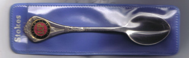
Souvenir spoon, Russell Stokes MLA, 1964
The spoon is a souvenir of the 1964 electoral success of Russell Stokes Liberal MLA for Evelyn.The spoon is a memento of the 1964 election campaign. Russell Stokes was the member for Evelyn 1958-1973. His home was 'Lubra Bend' in Yarra Glen. The item was manufactured by his family firm, Stokes Australasia. Founded in 1856, the firm made a variety of products including the gas lamps in Victoria's parliament and the original 'Rising Sun' badges worn by the Australian Army. See also item 2004.Stainless steel spoon with red and dark blue enamel medallion with gold lettering on handle. In plastic sleeve, blue back, clear front.Sleeve has 'STOKES'.russell stokes, evelyn, liberal, mla, spoon, metal manufacture, stokes australasia. -
 Mount Evelyn History Group
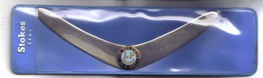
Souvenir boomerang, Russell Stokes, 1967
The boomerang commemorates the successful 1967 election campaign of Russell Stokes, MLA for Evelyn 1958-1973. It was manufactured by his family's firm, Stokes Australasia Limited. Russell Stokes' home was 'Lubra Bend', Yarra Glen.The boomerang is both a souvenir of an election campaign by a long-serving member of the Parliament of Victoria and an example of metal and enamel work by a Ringwood company that is now over 150 years old. See also item 2003.Stainless steel miniature boomerang with round enamel badge, light blue with dark blue border and gold lettering on bend. In plastic display sleeve, blue back, clear front.Sleeve has 'Stokes' in white lettering.russell stokes, metals, badges, souvenirs, evelyn, ringwood, lubra bend, yarra glen, parliament of victoria. -
 Monbulk RSL Sub Branch
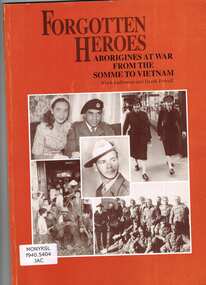
Book, Alick Jackomos et al, Forgotten heroes : Aborigines at war from the Somme to Vietnam, 1993
The involvement of Victorian and New South Wales Aboriginal people in war; World War One; World War Two; Korea; Vietnam; James Lovett; Hannah Lovett; Reg Rawlings; Henry Thorpe; John Firebrace; Dan Cooper; Jackson Stewart; Reg Saunders; Harry Saunders; George Birkett; Bill Egan; Jack Kennedy; Linda (Lester) Nihill; Marge Tucker; Alice Lovett; Connie Alberts; Stewart Murray; Norman Herbert Franklin; Bill Edwards; Lester Marks Harradine; Clarke family; Merv Bundle; Leo Maxwell Muir; Glen James; Graham Atkinson; Pat Owen; Cummeragunga; Lake Tyers; Framlingham; list of Aboriginal servicemen and women; different treatment of Aboriginal people during the war and after; introduction by Terry Garwood annotated separately.Ill, p.88.The involvement of Victorian and New South Wales Aboriginal people in war; World War One; World War Two; Korea; Vietnam; James Lovett; Hannah Lovett; Reg Rawlings; Henry Thorpe; John Firebrace; Dan Cooper; Jackson Stewart; Reg Saunders; Harry Saunders; George Birkett; Bill Egan; Jack Kennedy; Linda (Lester) Nihill; Marge Tucker; Alice Lovett; Connie Alberts; Stewart Murray; Norman Herbert Franklin; Bill Edwards; Lester Marks Harradine; Clarke family; Merv Bundle; Leo Maxwell Muir; Glen James; Graham Atkinson; Pat Owen; Cummeragunga; Lake Tyers; Framlingham; list of Aboriginal servicemen and women; different treatment of Aboriginal people during the war and after; introduction by Terry Garwood annotated separately.australia - military forces - aboriginal members, australia - aboriginals - personal histories - military -
 Benalla Art Gallery
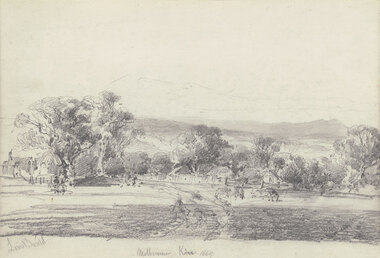
Drawing, Louis BUVELOT, Melbourne Kew (Yarra Glen), 1869
Born: Morges, Vaud, Switzerland 1814; Lived and worked: Brazil 1835-1852; Arrived: Melbourne, Victoria, Australia 1865; Died: Melbourne, Victoria, Australia, 1888ColonialLedger Gift, 1987Rural landscape with two animals beside a track leading towards buildings and outbuildings surrounded by trees with hills in distance. Timber frame.Recto: Signed "Louis Buvelot" in grey pencil in l.l.c of composition; Titled and dated 'Melbourne Kew 1869' in grey pencil in lower centre of compositiondrawing, landscape, figures, trees, colonial, road, animals -
 Whitehorse Historical Society Inc.
Map, Yarra River, 1839
Copy of T.H. Nott's original survey of 'Yarra Yarra River' taken from 'Lilydale' by Grace Aveling.Copy of T.H. Nott's original survey of 'Yarra Yarra River' taken from 'Lilydale' by Grace Aveling. Covers area from Templestowe to Yarra Glen.Copy of T.H. Nott's original survey of 'Yarra Yarra River' taken from 'Lilydale' by Grace Aveling. maps, yarra river -
 Whitehorse Historical Society Inc.
Photograph, Blackburn Open Air School No 3850
Blackburn Open Air School No 3850 Gardenia St. In 1915 the Education Department built a school in Gardenia Street Blackburn for anaemic and ill nourished children from Richmond, Sth Yarra, Glen Ferries and Burnley.Twenty-five children travelled by train to Blackburn Railway station. After lunch supplied by school authorities, the children were supposed to rest for 1 hour in the open air. Despite healthy diet anaemia didn't improve but the children were healthy and brighter. After WWII extra facilities were added and the Oslo lunch introduced. With improved welfare in 1963 the dept closed the school and used it for social work and Speech Therapy.Black and white photograph of the Open Air School, Blackburn showing the building in a bush setting with deck chairs on the left.blackburn open air school no 3850. schools. open air school, blackburn school -
 Southern Sherbrooke Historical Society Inc.
Photograph - Adults and children with a horse and cart in Belgrave South, c.1940s
Black and white photo showing three adults and two children with a horse and cart. Mr Archibald William Muirhead, of 7 Colby Drive, Belgrave Heights (then called Glen Rd) stands to the left of the cart with his left hand resting on the wheel and his right hand on his hip. His left leg is crossed in front of his right leg. He is wearing a light-coloured suit. Sitting in the cart are two women and a boy and a girl. The girl is Pam Harris. They are on a dirt road with trees on either side. Behind them is a cleared area with more trees in the background. The photo was taken on Glen Road close to Monbulk Creek. On the back of the photo is printed '1627'. It probably dates to the 1940s and is part of a collection of family photos donated by Pam Harris, Shire of Sherbrooke President, 1982-1983 & 1987-1988. -
 Kew Historical Society Inc
Album - Photograph Album No.1, Henry Beater Christian, 1924-26
Henry Christian (c.1809-91), the grandfather of the photographer, was one of the first settlers in Kew. He arrived in Victoria with his wife Agnes and son Orlando in 1855 on the Gypsy Queen. He established a rope-making business in Bulleen Road by 1858 but was declared insolvent two years later. In his final years, he was celebrated as one of the oldest living settlers of the district. His son, Orlando Henry Beater Christian (c.1853-1930) became a member of the Hawthorn Band and a foundation member of the Willsmere Swimming Club. Orlando and his wife Elizabeth had four children of which Henry Beater Christian (1886-1962) was the oldest.An album of photographs, compiled by Henry Beater Christian (1886-1962) of Pakington Street, Kew, depicting individuals, natural and settled environments and the interactions between these worlds. Henry Christian, was a keen explorer, not just of his immediate environment but also of the Victorian wilderness. His major opus is contained in two albums in which he records, sometimes in majestic detail and on other occasions the intimate features of the natural world. His photographic travels during the 1920s, often in solitary ramblings but on other occasions with companions, recall the heroic landscape photography of an earlier era, pioneered by Nicholas Caire. In addition to their aesthetic value, the albums are historically significant records within the State of Victoria, of what is now a distant point in time, and of places that have become radically altered through human intervention.Digital copy of a 47-page photograph album containing 255 gelatinous silver images, loaned by Diane Washfold with permission given to digitise and hold a copy in our collection. The album contains a groups of photographic positives taken by Henry B Christian (a resident of Pakington Street), of places in Kew and throughout regional Victoria during the 1920s. The mainly sepia photographs, while small, are of a high resolution. Photographs are typically lightly glued onto pages. Locations are frequently identified by white or black ink, which in a number of cases is illegible due to wear.henry beater christian (1886-1962), landscape photography, photograph albums, kew (vic.) — yarra river, kew (vic.) — zig-zag bridge, kew (vic.) — macauley’s boathouse, studley park (vic.) — yarra river, wonderland — grampians (vic.), black spur (vic.), marysville (vic.), maroondah dam (vic.) — construction, warburton (vic.), cockatoo (vic.), bruthen (vic.), swan reach road (vic.), glen hills (vic.), lightning creek (vic.), omeo (vic.), glen wills (vic.), mt wills (vic.), sunnyside (vic), granite flat (vic.), toolangi (vic.), yea (vic, )., flowerdale (vic.), mt white law (vic.), baw baw (vic.), christian-washfold collection -
 Surrey Hills Historical Society Collection
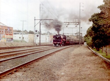
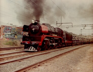
Photograph, A Yarra Glen Special approaching Surrey Hills, 1986
... Road Canterbury melbourne A Yarra Glen Special in 1986 ...A Yarra Glen Special in 1986 at Surrey HillsA coloured photograph of a steam train bellowing lots of smoke approaching Surrey Hills station. On the LHS is Stirling Crescent; on the RHS is Sunbury Crescent. There is graffiti on the buildings adjacent to the railway line on the LHS.On rear of photo : "A Yarra Glen Special / 1986/ at Surrey Hills"graffiti, surrey hills, steam train, trains, 1986, harris carriages -
 Surrey Hills Historical Society Collection
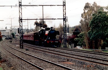
Photograph, Yarra Glen Special at Surrey Hills in 1986
Steam Rail Victoria is a Preservation Society which runs tour specials throughout Victoria. This particular train is being pulled by an R Class loco on a Yarra Glen Special. The carriages behind are Blue Harris carriages which were normally used on the electrified system. the train is approaching Surrey Hills from Chatham station.A coloured photograph of a Steam train blowing steam as it plows along pulling a number of blue carriages. There is some graffiti on the back of a building that backs onto the railway line.On back of photo: "A Yarra Glen Special / 1986 / At Surrey Hills"graffiti, surrey hills, steam trains, trains, 1986, harris carriages -
Vision Australia
Text, RVIB Yarra Glen Auxiliary, 1956 - 1997
... The Yarra Glen RVIB Auxiliary formed on March 19, 1956. This small ...The Yarra Glen RVIB Auxiliary formed on March 19, 1956. This small collection contains index cards which were maintained by RVIB and contain the amount of donations made by the Auxiliary between 1976 - 1995 as well as the presentations delivered by RVIB employees to Auxiliary meetings between 1978 - 1985. Correspondence to and from RVIB head office ranging between 1990 - 1999. Newspaper articles -- letters -- index cards and various loose papers royal victorian institute for the blind -
 Surrey Hills Historical Society Collection
Photograph, J515 Steam train leaving Chatham station towards Surrey Hills in c1991, 1991
This is one of the many steam rail specials heading for Yarra Glen or Belgrave and Puffing Billy. Sunbury Crescent is seen on the RHS of the photo.A coloured photograph of a steam train identified as 515 with a red coloured carriage behind it.steam trains, sunbury crescent, surrey hills station, rail specials -
 University of Melbourne, Burnley Campus Archives
Photograph - Black and white print, Glen Wilson, Australian Native Plants Under Mulch, Unknown
Note by E.B. Littlejohn 11 December 1991, "Glen Wilson submitted these photographs of his work using sawdust mulch, whilst attending Evening Classes."Black and white photograph with an envelope. View of an unmade road or drive with plants on each side surrounded by mulch.Envelope with caption, "Australian native plants under mulch ex Glen Wilson 334 Springvale Road Springvale 746-8824."native plants, glen wilson, sawdust mulch, evening classes -
 Eltham District Historical Society Inc
Photograph - Digital Photograph, Alan King, Panton Hill Hotel, 27 March 2008
Today’s Panton Hill Hotel was built around 1920. Published: Nillumbik Now and Then / Marguerite Marshall 2008; photographs Alan King with Marguerite Marshall.; p61 Panton Hill was originally known as Kingstown, and consisted of only one hotel when the Orams Reef was discovered in 1859. Kingstown was a quartz mining centre and many old mine shafts remain in the area. Orams Reef was one of the first reefs with a rich find of gold in the area. The Hotel Francais, which had been operating in 1861, was well situated on the way to Queenstown (later St Andrews). So was Herr Hirt’s Hotel and store at Smiths Gully. The Kingstown hotel, known as the Frenchman’s and in 1864 as the Hotel de France, was run by a Monsieur Emile Hude and his wife Jeanne, and known for its good food. They hosted social events, business conventions and debates, attracting patrons from as far as Melbourne. The hotel’s name was changed to Panton Hill Hotel in 1905. In 1883 Charles Caudwell built another hotel nearby, possibly in Long Gully Road,3 which it is thought, was burnt down early last century. Today’s Panton Hill Hotel, built around 1920, is the only one of the cluster of buildings in the main road, not to date from around the turn of last century. It was severely damaged by fire in 2003, then underwent extensive alterations. It is the township’s only hotel and is an example of a modest hotel building exterior, constructed early last century. In its early days the hotel also housed the first post office, newsagency and store. Orams Reef yielded a total of £100,000, and fossikers also found alluvial gold in the creeks and gullies, but there is no record of the total value of their finds. Gold greatly increased the Panton Hill population, which peaked between 1865 and 1885. On holidays large sports meetings were held with wood chopping contests and foot races and the day would end with a ball. Miners came from various countries to seek their fortune, including many from China. The Chinese became unpopular however, and gradually left the district, although some stayed and grew and sold vegetables.5 Panton Hill was named after Joseph Panton, who in 1862 was appointed Police Magistrate for the Woods Point, Heidelberg and Yarra districts. Panton was an outstanding man, who in 1852, was Commissioner of Crown Lands and Assistant Commissioner of Goldfields at Bendigo. In 1874 he was promoted to Chief Magistrate for the Melbourne Police. Panton was also an artist, becoming president of the Victorian Arts Society in 1888, and in 1913, president of the Royal Geographical Society. Despite Panton Hill’s prosperity, it still lacked many services as poor roads made access to Melbourne difficult. A horse-drawn mail coach travelled to Melbourne until 1890, when the railway came to Heidelberg. The nearest doctor was at Yarra Glen or Heidelberg, and the Indian hawker Singh’s annual visit was very welcome. A miner’s shack opposite the school was used as a post office. Today’s general store and post office in the main road dates from early last century, and has changed considerably. While most people searched for gold, the more enterprising ones established farms to feed the diggers. Farmers grew wheat, barley and oats, and sent animal skins to the Eltham tannery, to make furs in Melbourne. As gold became scarce from around 1880, miners took up farming on 19 to 20 acre (8ha) allotments. The first settlers in Cherry Tree Road included Purcell, Smith, Owens, Hughes and Shillinglaw. By 1900 all the land had been taken up around Panton Hill and Hurstbridge. The orchards in Panton Hill and the wider district, particularly of apple and pear, were very successful, and made Panton Hill a cohesive and successful community. About 1914 the Moores built the first cool-store and refrigeration plant at their orchard in Cherry Tree Road. Many settlers planted vineyards and made high quality wine, but in 1922 the blight destroyed them.This collection of almost 130 photos about places and people within the Shire of Nillumbik, an urban and rural municipality in Melbourne's north, contributes to an understanding of the history of the Shire. Published in 2008 immediately prior to the Black Saturday bushfires of February 7, 2009, it documents sites that were impacted, and in some cases destroyed by the fires. It includes photographs taken especially for the publication, creating a unique time capsule representing the Shire in the early 21st century. It remains the most recent comprehenesive publication devoted to the Shire's history connecting local residents to the past. nillumbik now and then (marshall-king) collection, panton hill hotel -
 Eltham District Historical Society Inc
Photograph - Digital Photograph, Alan King, Nillumbik Shire Offices, Greensborough, 30 March 2008
Nillumbik Shire Council transferred to the former Diamond Valley Shire Offices in Greensborough after municipal restructuing. The offices became the official Nillumbik Shire Council Offices on 16 October 1995. The former Shire of Diamond Valley Civic Centre or Shire Office building was officially opened on 26th February 1972. Archtiects were A.K. Lines, McFarlane & Marshall and it was built by L.U. Simon Pty Ltd, The Diamond Valley Shire had been created in 1964 from part of the City of Heidelberg. On December 15, 1994 the Shire of Nillumbik was established. Under the Council amalgamations imposed by the Kennett government, the Shire of Eltham, Shire of Diamond Valley and City of Heidelberg ceased to exist with the establishment of Nillumbik Shire Council and the City of Banyule.The new Nillumbik shire surrended the west riding from Eltham to Banyule but in place gained parts of the former Diamond Valley Shire which itself had been created in 1964 from parts of the City of Heidelberg. Three unelected and non-local Commissioners were put in place by the government bringing democracy into question by many members of the local community. The Commissioners determined to abandon the former Shire of Eltham offices located in Main Road, Eltham and in turn occupy the former Shire of Diamond Valley offices located at the boundary of the new shire with Banyule, in Civic Drive, Greensborough. In July 1996 the Commissioners sold the former Eltham Shire Offices and had them bulldozed leading to many years of communiity protest over the process and future development applications. The site has remained vacant ever since. Published: Nillumbik Now and Then / Marguerite Marshall 2008; photographs Alan King with Marguerite Marshall.; p43 It was the need for roads that led to this district’s first council. In 1853 a committee was formed to improve the rough roads, some in Kangaroo Ground being almost impassable in winter.1 The committee fundraised by voluntary levies and grants to improve in particular, the main road between Kangaroo Ground and the Plenty River. From this committee arose the Eltham District Road Board, in 1856, which was the precursor to the Eltham Shire Council. The Board’s first chairman was Kangaroo Ground farmer, John Barr. Secretary was the former committee’s secretary, Andrew Ross, Kangaroo Ground’s first school teacher, and founder of the district newspaper, The Evelyn Observer.2 Most of the board’s income came from a toll-house north of the Lower Plenty Bridge, which funded such projects as a road from Kangaroo Ground to the Caledonia Diggings. In 1871 the Shire of Eltham was proclaimed, with its boundaries the same as those of the Road Board, and Councillor A Donaldson of Kangaroo Ground was the first president. Eltham was at the southern tip of the shire, which extended north to Kinglake and east beyond Yarra Glen. In 1878, part of Kinglake was added to the shire, while the area east of Watts River, near Healesville was removed. In 1912, then again in 1958, the shire was further reduced. Yarra Glen, Steels Creek, Tarrawarra, parts of Healesville and Christmas Hills, were transferred to the Shire of Healesville. In 1972 a smaller area, at Kinglake, was transferred to the Shire of Yea, leaving 277 square kilometres in the Eltham Shire. Perhaps no other Victorian municipality has had so many meeting places. Although from 1858 to 1904, the council convened at the office in the home of Secretary Charles Wingrove, the board, and later the council, also met at other more central locations.3 The board moved from the Fountain of Friendship Hotel to the Eltham Courthouse, to the Kangaroo Ground schoolhouse. It then met at the Kangaroo Ground Hotel, which some considered put it in danger of interruptions by people ‘the worse for liquor’.4 In 1885 the council met at the hall on Mr J Donaldson’s land at Kangaroo Ground. After Wingrove’s retirement, the council rented space at the Kangaroo Ground General Store and Post Office. Then, in 1917, the council bought the former office of The Evelyn Observer, after its printing works transferred to Hurstbridge. In 1934, fire destroyed the shire office, which was temporarily relocated to the Kangaroo Ground home of Shire Secretary, Mr P J McMahon. In 1941, the shire office moved to a new building (which included a public hall) in Eltham, at the corner of Arthur Street and Main Road, where the Eltham Village Shopping Centre was eventually built. Growth required new offices, which opened in 1965, on the former Shillinglaw property in Main Road.5 In 1994, as part of municipal restructuring under the Jeff Kennett Liberal Government, most of the Eltham Shire formed part of the new Shire of Nillumbik. It joined with the north section of the Diamond Valley Shire and parts of the Healesville and Whittlesea municipalities. The Diamond Valley Shire had been created in 1964, from part of the City of Heidelberg. Turbulence followed Nillumbik Shire’s formation. Under the Commissioners the council transferred to the former Diamond Valley Shire offices in Greensborough, and the Eltham council offices were demolished. In March 1997 the first five-member Nillumbik Council was elected. But, in October 1998, the government suspended the council and appointed an administrator . Early in 1999, shire residents voted to increase councillors to nine: comprising five ward councillors and four shire-wide councillors. Elections were held in March 1999. Then, before the March 2002 elections, nine new wards were created.6 In 2008 these were reduced to seven. Today [2008] the council governs a varied population of more than 60,000 people living in townships and on bush properties in the green wedge.This collection of almost 130 photos about places and people within the Shire of Nillumbik, an urban and rural municipality in Melbourne's north, contributes to an understanding of the history of the Shire. Published in 2008 immediately prior to the Black Saturday bushfires of February 7, 2009, it documents sites that were impacted, and in some cases destroyed by the fires. It includes photographs taken especially for the publication, creating a unique time capsule representing the Shire in the early 21st century. It remains the most recent comprehenesive publication devoted to the Shire's history connecting local residents to the past. nillumbik now and then (marshall-king) collection, greensborough, nillumbik shire council offices, civic drive -
 Eltham District Historical Society Inc
Photograph - Digital Photograph, Marguerite Marshall, Strathewen Public Hall, 20 August 2008
Strathewen Public Hall, social and spiritual centre was later lost in the Black Saturday fires 2009. The Strathewen Community decided a community hall was needed in 1901. In 1902 locals built the hall with messmate trees. It was located on the Cottlesbridge-Strathewen Road. The first function was a Grand concert and Balll attended by about 120 people. Several denominations held Church services and Sunday School services in the Hall. It survived several bushfires until after this photo was taken when it was destroyed in Black Saturday, 9 February 2009. Published: Nillumbik Now and Then / Marguerite Marshall 2008; photographs Alan King with Marguerite Marshall.; p89 Strathewen was settled late, largely because it was difficult to access.1 Early selectors found it a struggle to survive. They had to do everything themselves, from felling trees for buildings, to taking produce to market along bush tracks that they had helped cut. Small dairy farms were typical but fruit became the district’s prime produce. The first settlers east of Arthurs Creek were brothers John and Duncan Smith whose station Glen-Ard was probably operated as a sheep run. Other early settlers were the Mann family, who were to donate land for the hall, provide postal services and John Mann was an Eltham Shire councillor from 1916 to 1919.2 In 1873 James Mann, his wife Jane and their six children, settled on 207 acres (83.7) (Lang Fauld Farm) on both sides of Eagles Nest Road, from the foot of Mount Sugarloaf to the bank of the Arthurs Creek. In 1883 James took up another selection on Chads Creek. It was very hard work and at times he was well behind with his rent. However the family had a good social life, attending the Primitive Methodist Church at the Arthurs Creek Township and on New Year’s Eve throwing a party for all the locals. By 1874 James Mann’s younger brother, John, selected 311 acres (125.8ha) between Eagles Nest Road and upper Arthurs Creek. He called it Carseburn after his home parish in Scotland. Tragically in 1875 John drowned in the Yarra River, at Richmond.3 John Mann’s oldest son, also John, later purchased Duncan Smith’s land, which he named Violet Glen. He was to give one acre (0.4ha) of this land for the Strathewen Hall site. A Mann family diary written at Carseburn in 1897, tells how the district’s name was selected. Strathewen is derived from ‘strath’ meaning ‘broad mountain valley’ and from the name of Ewen H. Cameron, the local parliamentarian for almost 40 years. ‘George Brain came around to get a petition signed to get a post office up here and we had to vote for a name—Strathewen, Glen-Ard, or Headcorie’.4 It was at Carseburn that a public meeting in 1901, decided to build the Strathewen Hall on the Cottlesbridge-Strathewen Road. In 1902 the locals built the hall with messmate trees. The first function was a Grand Concert and Ball attended by around 120 people and several Protestant denominations took turns to hold church services and Sunday School there. Fortunately the hall has survived bushfires to be the town’s spiritual and social centre.5 The area continued to develop and in 1909 a post office operated somewhere at Strathewen and from around 1916 at Carseburn.6 It was not until 1914 that land was bought to establish the Strathewen State School on School Ridge Road. The residents paid £100 to build it on two acres (0.8 ha) while the Education Department contributed £30 and leased the building annually for £1. When teacher Miss Mary Golding opened the school in 1917, it had no equipment.7 But in 1921 the Education Department provided desks and a hexagonal shelter shed (now a rare style in Victoria) and took control in 1925.8 By 1917 Strathewen was booming.9 George Apted had built a coolstore in 1916, and local orchardists bought storage space until the 1950s. This allowed the area to supply the market in and out of season. Guesthouses catered for growing tourism. In the mid 1920s Mrs Eleanor Sparkes built the guest-house Singing Waters, which operated through the 1930s. Her daughter Mrs Vera McKimmie, ran it until the 1950s and the house remains in Chads Creek Road. In the Great Depression land was cleared for timber to be sold as firewood and there was small scale sawmilling. However the orchard industry diminished for several reasons including the 1939 bushfires and rapid changes in production methods. Today the Apteds still operate an orchard and farm at Glen-Ard, which straddles the border between Strathewen and Arthurs Creek. It includes the southern part of Duncan Smith’s original Glen-Ard selection.This collection of almost 130 photos about places and people within the Shire of Nillumbik, an urban and rural municipality in Melbourne's north, contributes to an understanding of the history of the Shire. Published in 2008 immediately prior to the Black Saturday bushfires of February 7, 2009, it documents sites that were impacted, and in some cases destroyed by the fires. It includes photographs taken especially for the publication, creating a unique time capsule representing the Shire in the early 21st century. It remains the most recent comprehenesive publication devoted to the Shire's history connecting local residents to the past. nillumbik now and then (marshall-king) collection, strathewan public hall -
 Emerald Museum & Nobelius Heritage Park
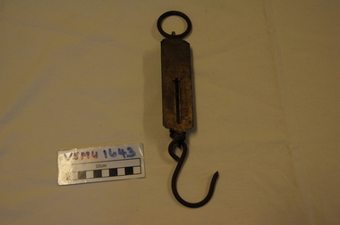
Orchadist Scales, Donated by Frank Eckerman (Emerald)
Used in orchards by Harry Shaw (Orchardist in Springvale Rd, Glen Waverley near cnr Highbury Road) Orchard was sold in 1950. Later used on poultry farm in Forest Hills.Body of scales: brass plate inscribed - Salter Pocket Balance, made in England. No.3. To weigh 50LB. Slide measure 0 to 50. Pattern at top: twisted rope with arrow through middle. Reverse side: green painted metal. Hanging metal ring at top end and metal hook at lower end. Salter Pocket Balance, Made in England. No.3. To weigh 50LB. -
 Melbourne Tram Museum
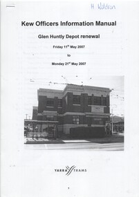
Manual, Yarra Trams, "Glen Huntly Depot Renewal", "Kew Depot - Pit Deepening Roads 1 to 4", "Camberwell Depot Yard Tracks Renewal", 2007 to 2011
Set of three Reports or Operations Plan or Manual for work at Kew and Glen Huntly Depots. .1 - 12 A4 pages - stapled - "Kew Officers Information Manual - Glen Huntly Depot renewal" - Friday 11 May 2007 to Monday 21st May 2007". Has a photo of the depot on the front sheet. Covers service changes, arrangements for changes to services running from Kew Depot, car parking, tram requirements. Has a table of contents. .2 - 7 A4 pages - stapled - "Operations Plan - "Kew Depot - Pit Deepening Roads 1 to 4" = Monday 23 June 2008 to Friday 18 July 2008" - has a table of contents, covers maintenance, tram requirements, out stabling, security, sanding and hours of operation. .3 - 19 A4 pages - stapled - "Camberwell Depot Yard Tracks Renewal" - Saturday 3 December 2011 to Monday 12 December 2011 - has a table of contents, service changes, car parking, stabling, maintenance, operations, sanding, cleaning, rosters and test trams and notice to employees. .4 - 3 A4 foolscap sheets - Co-ordinating plan for Kew Depot / Barkers Road entrance and High Street and Cotham Road - dated 25/11/2005 - list works, location, overhead, cabling, track and other works and isolation requirements. On the rear has a list of the trams for the depot, Collins St, Simpson St and Camberwell. .5 - Notes on the Kew Depot relay by Hugh Waldron received in an email dated 9/3/2018 - from Kew Depot History..1 - Has "H. Waldron" in top left hand corner in blue ink. .2 - ditto "Hugh" in red ink.trams, tramways, yarra trams, kew depot, glenhuntly tram depot, trackwork, depot fan, tram services -
 Melbourne Tram Museum
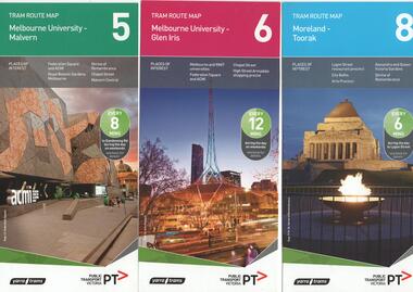
Ephemera - Tram Route Guides, Public Transport Victoria (PTV), "Tram Route Map", 1/2015 and 6/2015
Set of 7 Tram Route Maps, published during 2015. Each comprises a vertical DL folded sheet, full colour for the nominated routes, with Yarra Trams and PTV logos, listing the stops, interchanges with bus and other tram services, ticketing zones, estimated frequencies with adverts for Night tram services, TramTracker and Myki tickets. .1 - Route 5 - Melbourne University to Malvern .2 - Route 6 - Melbourne University to Glen Iris .3 - Route 8 - Moreland to Toorak .4 - Route 11 - West Preston - Victoria Harbour Docklands .5 - Route 19 - North Coburg - Flinders St Station .6 - Route 70 - Wattle Park to Waterfront City Docklands .7 - Route 72 - Melbourne University to Camberwell .8 - Route 1 - East Coburg - South Melbourne Beach .9 - Route 3 and 3A - Melbourne University to East Malvern .10 - Route 16 - Melbourne University to Kew .11 - Route 55 - West Coburg - Domain Interchange .12 - Route 57 - West Maribyrnong - Flinders St Station .13 - Route 59 - Airport West - Flinders St. Station .14 - Route 64 - Melbourne University - East Brighton .15 - Route 67 - Melbourne University - Carnegie .16 - Route 78 - North Richmond - Balaclava via Prahran .17 - Route 82 - Footscray - Moonee Ponds See Reg Item 2396 for 2012, 2278 for 2016 and 2940 for 2014 versionstrams, tramways, timetables, maps, route 1, route 3, route 5, route 6, route 8, route 11, route 16, route 19, route 55, route 57, route 59, route 64, route 67, route 70, route 72, route 78, route 82, east coburg, south melbourne, east malvern, kew, west coburg, west maribyrnong, airport west, east brighton, carnegie, north richmond, balaclava, footscray, moonee ponds, malvern, glen iris, moreland, west preston, north coburg, wattle park, camberwell -
 Melbourne Tram Museum
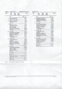
Administrative Record - Table Cards, Yarra Trams, Malvern Depot, run 183, 2010
Table card for Malvern Depot, run 183, effective 2/1/2011 Printed A4 sheet, folded to go into in a plastic folder providing the table for a driver to operate to - routes and times along each route, and times starting and finishing, (on and off) and meal breaks. Table 183 from Malvern Depot, giving car out times, destination times for Glen Iris, University, Camberwell, Meal breaks, Camberwell and monitoring points. Printed 17/12/2010.trams, tramways, table cards, malvern depot, drivers -
 Melbourne Tram Museum
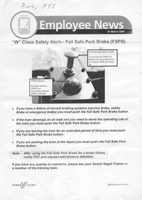
Document - Instruction, Yarra Trams, "W class Safety Alert - Fail Safe Park Brake", "Malvern Terminal Procedures", 24/03/2006 12:00:00 AM
.1 - single A4 sheet - titled "W class Safety Alert - Fail Safe Park Brake", dated 24/3/2006, detailing procedures for the use of the parking braking system fitted to W class tramcars. Includes a photograph of the button. .2 - Instruction - from Staff Induction Manual, detailing terminus procedures for Malvern Depot; University terminus, Malvern Burke Road, Glen Iris, Camberwell and Kew terminus for Z and Combino trams .3 - as above, but includes Luna Park terminus.1 - Has "Ron, FYI" in ink on the top left hand corner.trams, tramways, w class, braking, instructions, malvern depot, university, burke rd, glen iris, kew, luna park, camberwell -
 Melbourne Tram Museum
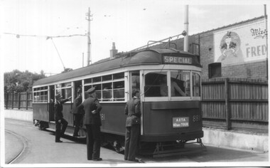
Photograph - Set of 5 Black & White - First AETA tour, 15-2-1947
Set of five photographs of the first Australian Electric Traction Association (AETA) tram tour of Melbourne on 15/2/1947. See page 8 of the March 1947 issue of "Tram Tracks" for details of the tour and the MMTB Crew. 1 - SW6 881 about to leave Glen Huntly Depot 2 - Crossing Balaclava Junction 3 - Crossing the Kooyong railway level crossing in Glenferrie Road - has the railway signal box and gates in view. 4 - Turning into Riversdale Road from Glenferrie Road with the Stotts Business College building in the background. 5 - Just to the east of Yarra River Bridge in Swan Street with the Burnley Gardens on the right.Yields information about the first AETA tram tour in 1947Set of 5 Black and white photograph on paper. Two copies of each held.Each one of the set has a photographers file stamp on the rear, but no details filled in.trams, tramways, aeta, tram tours, tram 881, sw6 class, glen huntly, kooyong level crossing, glenferrie road, riversdale road, burnley, hawthorn, balaclava junction, glen huntly depot, hawthorn road, swan st -
 Melbourne Tram Museum
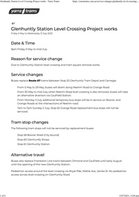
Document - Project Notice, Yarra Trams, "Glenhuntly Station Level Crossing Project works", May 2023
Project notice for - "Glenhuntly Station Level Crossing Project works" - tramway square. Gives details of alternative bus arrangements, maps and timing for the works. Work scheduled 5/5/2023 to mid July 2023.Yields information about the removal of the Glen Huntly station/road level crossing and the associated trackwork.Notice - 6 A4 page document - pdf version downloaded and printed version.tramways, public transport, level crossing, glen huntly road, glenhuntly, railway square, tramway square, trackworks -
 Melbourne Tram Museum
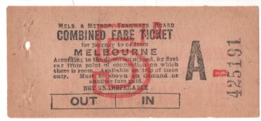
Ephemera - Ticket/s, Melbourne & Metropolitan Tramways Board (MMTB), "Combined Fare Ticket" - MMTB, early 1930's?
Ticket - light brown paper, "Combined Fare Ticket" - MMTB, over printed with a red 5d, and Ticket Number A B 425191. with conditions of travel on the front. On the rear is printed in red ink is an advert for B. Matthews Pty Ltd, with head office at 102-110 Toorak Road, South Yarra, advertising a Motor Funeral Service. Dean Filgate advised 24-12-2020: Unfortunately an un-used example, from the same block that most collectors obtained one for their collection ! There are genuine used examples of similar 6d (purple overprint) tickets, however I cannot find my "files" about these: there were at least two places this type of ticket was used in the early to mid-1930s. One was a "Combined Fare Ticket to and from the City via The Coburg Electric and Brunswick Cable Cars", the other was used on the Glen Huntly lines to enable passengers to pay only once for their journey to the City, as until 1934 trams from Glen Huntly Depot did not run direct to the City - you had to transfer trams at Elsternwick or Ripponlea.trams, tramways, melbourne, tickets, mmtb, advertisements -
 Melbourne Tram Museum
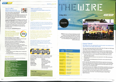
Magazine, Yarra Trams, "The Wire", 5/2011 to 1/2015
0 - No 9 - 1/4/2011 - Rhinos on skateboards, Did you know, Spencer St works, .1 - No. 11 of 3/5/2011 with the revised Yarra trams logo, traffic priority, work over Easter in Spencer St at Bourke and Collins St, Good Friday appeal, safety, passenger feedback and future works. .2 - No. 13 - 31/5/2011 - new uniform, cleaning, CEPR, trackwork - Fitzroy St, Northcote, Rhino, Carlton Control. .3 - No. 14 - 15/6/2011 - Haymarket Roundabout, accessibility, maintenance, CSE. .4 - No. 17 - 2/8/2011 - High St Westgarth trackwork, Swanston St, IMF CEO visit .5 - No. 18 - 16/8/2011 - Performance benchmarks met, Preston Workshops, repairs to 3018, tram signal priority. .6 - No . 19 - 30/8/2011 - New E class trams, routes "a" or "d", TramTracker in shelters, police, fare evasion .7 - No. 20 - 15/9/2011 - Football trams, Superstops, Bridge Road, Rhinos. .8 - No. 21 - 27/9/2011 - CEO's journey to work, accessibility, increased patronage, E class. .8a - No. 22 - 11/10/2011 - Minister Mulder visit, E class, Customer experience, Elizabeth Kerdelhue Corporate Affairs Director, flood indicator in Wellington Parade, Keolis - Orleans and PTV coming your way. .9 - No. 23 - 25/10/2011 - forthcoming royal visit, opening for Footscray Road extension, Rhinos, Stockholm .10 - No. 24 - 8/11/2011- Royal visit, photos, Z3 158, route 86 works in High St. (see htd5043i21 for a image from an unknown newspaper of the actual event - features Z3 158.) .11 - No. 25 - 22/11/2011 - new staff guide, Gold Coast tram line, Macarthur St, overhead, fund raising, route numbering update. .12 - No. 26 - 6/12/2011 - Swanston St Superstops, Newmarket bridge strikes, rhinos. .13 - No. 27 - 20/12/2011 - Christmas carnival, Lenny Bates, portable crossover, uniforms. .14 - No. 28 - 17/1/2012 - Passing of Len Bates, Myki, Gardiner railway station. .15 - No. 30 - 15/2/2012 - visit of Keolis, SNCF people, list of Executive leadership team with photos, Swanston St works, Myki introduction. .16 - No. 31 - 29/2/2012 - patronage up, tram postage stamps, Myki, rhinos. .17 - No. 32 - 14/3/2012 - St Kilda Rd trackwork, fund raising, Southbank Depot extensions, Myki, driving conditions, grand prix. .18 - No. 33 - 30/3/2012 - introduction of the PTV, end of MetLink and Transport Ticketing Authority, changes in management structure, trackwork, Gold Coast tramway and Keolis. .19 - No. 34 - Dr Jake - Royal children's Hospital super stop, route 96 - Premium line. .20 - No. 35, 2/5/2012 - Revision of Rules, trackwork in St Kilda Road and Elizabeth St, Myki, safety - Zero Harm. .21 - No. 69 - 25/9/2013 - Passengers paying their way, E class update, Mal Ashworth retires, progress report, feedback, new chime on trams. .22 - No. 70 - 9/10/2013 - Art comes alive, tram 925, driver simulator at Preston Workshops, E class project, 90th Glen Huntly. .23 - No. 83 - 23/4/2014 - Screen time for trams, new PIDs on B class, assistance animals, Operations Centre, Preston Workshops, Electrical log sheets to SLV. .24 - No. 89 - 23/7/2014 - punctuality, refresh of network map (fold-out map), women drivers. .25 - No. 97 - 19/11/2014 - Revitalising route 96, Keolis news, free tram zone, guide dogs. .26 - No. 99 - 17/12/2014 - Accessibility week, new uniform top for CSE's, free tram zone, world trade centre stop upgrade, heat stress, Art tram 158. .27 - No. 100 - 14/1/2015 - Route 96 complete, New Years eve free travel, fare compliance, patronage down, .28 - No. 12 - 16/5/2011 - Gold coast tramway, performance dashboard, tramworks and the rhino .29 - No. 16 - 19/7/2011 - Depot managers, tevor jones, record patronage, vision, rhino .30 - No. 17 - 2/8/2011 - High St Westgarth works, Duncan Smith, David Clarke Training, Swanston St works, and Preston Workshops .31 - No. 29 - 31/1/2012 - Southbank depot, patronage, myki, think like a passenger, fatigue management, .32 - No. 39 - 28/6.2012 - maintenance, Emmanual Sorin, transformation, fare evasion, and Combino in Potsdam. .33 - No. 105 - 25/3/2015 - Grand Prix, Elgin and Lygon upgrade, Camberwell Junction, PTV hub, overhead.Demonstrates Yarra trams staff newsletters.Set of 33 Yarra Trams internal newsletter "The Wire", All A4, printed in full colour. All four pages unless noted otherwise, full colour, performance snapshot on front cover.trams, tramways, yarra trams, traffic control, trackwork, spencer st, fund raising, operations, rhinos, carlton control, high st, haymarket, preston workshops, e class, route numbers, bridge road, wellington parade, ptv, royal visit, footscray road, new tramway, gold coast, macarthur st, swanston st, superstops, newmarket, gardiner, burke road, level crossings, railway squares, myki, metlink, tickets, route 96, rules, st kilda road, elizabeth st, tram 158, tram 925, glen huntly depot, simulator, b class, opeations centre, art trams, patronage