Showing 10388 items
matching plan
-
 Lara RSL Sub Branch
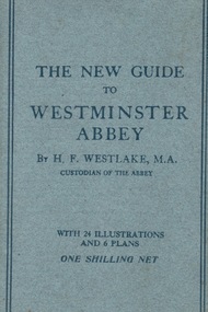
Book, A.R. Mowbray & Co Ltd, The New Guide to Westminster Abbey, August 1916
Brought back to Australia by J. McIntyre from WW1Part of Souvenirs brought back from WW1 by J.McIntyre Light blue cardboard covered book with paperFront Cover 'The New Guide to Westminster Abbey by Br. H.F.Westlake, M.A. Custodian of the Abbey with Illustrations and 6 Plans One Shilling Netwestminster abbey, h.f.westlake, ww1, mowbray & co. ltd, london, j. mcintyre -
 Tatura Irrigation & Wartime Camps Museum
Photograph, Central Planning Office, Camp 2 aerial, 1989
Black and white aerial photo of camp 2on the back: camp 2 W/c 0065 Vic 82/.9032 Max 1989 Central Planning Office Treasury Place Melbourne -
University of Melbourne, Burnley Campus Archives
Plan - Photocopy, New Cottage for Caretaker Royal Horticultural Gardens Burnley 1897, 1897
Photocopies. New cottage for Caretaker, Royal Horticultural Gardens Burnley (1) Elevations, Ground floor and Roof plans. Drawing No 1 dated 5th March 1897 GB 5198. (2) Detail Drawings. Drawing No 2. From Public Records Office.Signed SEM (?) 5-1-97; J. Fisher, F.J. Moore (?) 5 Mar. 97caretaker's cottage, burnley gardens -
 University of Melbourne, Burnley Campus Archives
Plan, Water Garden, 1987-1995
(1) Water Garden V.C.A.H Burnley Irrigation Plan, drawn by M.D. 12.11.87. (2) Tracing paper copy, Proposed Pool Development Native Garden V.C.A.H. Burnley -Survey of approximate dimensions showing fall and depth of pools. Drawn by J.H.K. 9.9.88. (3) Rough coloured plan, Water Garden Planting Plan. (4) Proposed Water Garden V.C.A.H. Burnley by Robert W. Boyle and Associates October 1988, with handwritten annotations by James Hitchmough. (5) Coloured final version. (6) Tracing paper copy, Planting Scheme Native Garden VCAH Burnley. Design by James Hitchmough. Drawing J.K. 13.8.90. (7) Section Native Grassland Burnley Campus - Larger Tree Cover by Marika Kocsis & Martin Hopkins. Drawn by Leigh Stone 25.9.95. Survey Plan, no key to numbers. (8) Section Native Grassland by Marika Kocsis & Martin Hopkins. Drawn by Leigh Stone 20.9.95. No key to numbers. (9) Tracing paper copy Native Garden by Paul Eaves 6.9.90. Scale 1:100. Also 2 plant lists (11.0478/1 and /2). Also see 11.0478 List of plants. (11) Letter to P. Tulk from Robert Boyle dated 07.10.1988 "Re: Cost Estimates for Construction of Proposed Water Garden."water garden, vcah, robert w. boyle, james hitchmough, jill kellow, marika kocsis, martin hopkins, leigh stone, paul eaves -
 Ringwood and District Historical Society
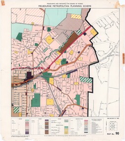
Map - Melbourne Metropolitan Planning Scheme, Municipality of Ringwood area - circa 1970
Colour-coded map marking proposed and existing business, industrial, transportation, public reservation, etc. planning zones within the City of Ringwood. Includes (undated) certification that this map is one of the maps constituting the Melbourne Metropolitan Planning Scheme Map.Scale: 800 feet to 1 inch. -
 Federation University Historical Collection
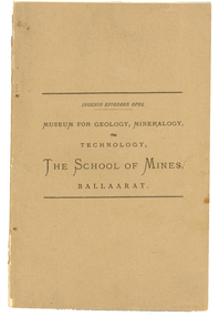
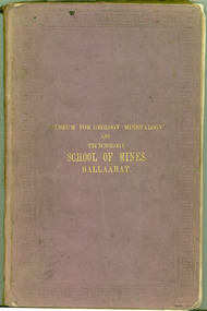
Book - catalogue, Charles Boyd, Museum for Geology, Mineralogy, Technology, Ballarat School of Mines, Ballaarat, 1882, 1882
The Ballarat School of Mines, Museum and Laboratories were open for inspection free in 1882, and an officer was ready to accompany and afford information to visitors. A brown soft covered book of 94 pages. It is a descriptive catalogue of the Minerals in the Museum of the Ballarat School of Mines by Ferdinand M. Krause, curator. Illustrations include a plan of the museum and a plan of the Ballarat school of Mines grounds and buildings. The book is indexed.ballarat school of mines, museum, krause, botanic garden, geology, oddie, james oddie, minerals, ferdinand krause, ballarat school of mines museum, ferdinand krause -
Bendigo Historical Society Inc.
Map - VICTORIA HILL AREA, May 1971
Map: Bendigo Historical Society feature plan. There are 3 of these plans, one is without feature names and one has several places highlighted in pencil. Compiled by AHQ Survey Regiment, CMF Increment ( number 181 in Map Cupboard 1)map, bendigo, mining plan, victoria hill, bendigo historical society -
Glen Eira Historical Society
Plan - a'Beckett Street, 11, East St Kilda
A hand drawn site and floor plan of a building subdivided into 3 flats at 11 a'Beckett Street, East St Kilda; undated but prior to November 2010 by person unknowna’beckett street, east st kilda, flats, plans, garages, outbuildings, residential development -
Glenelg Shire Council Cultural Collection
Certificate - Certificate - Historic Buildings, Portland Town Hall, 1974
From the Victorian Heritage Register: The foundation stone of the original Portland Town Hall was laid by William Learmonth on 21st September, 1863 following a competition and subsequent public controversy over the permitted entry of architect John Barrow. The conservative classical design of municipal surveyor Alexander Ross was preferred and this axially planned design with central council chamber and side offices fronted by a fine axed pedimented gable entablature of basalt and Tuscan Doric pilasters was completed by 24th may 1864. The old Town Hall is one of a distinguished group of public buildings in Portland and an interesting example of conservative classical architecture of the first years of settlement in western Victoria. The basalt structure was partially erected of stone from the Portland stockade and has significant historical associations with local Government administration in the district. The Town Hall is the most impressive work of Alexander Ross, a surveyor architect whose career remains largely undocumented. The old Town Hall at Portland has been discreetly extended at the rear to provide additional meeting room accommodation. The premises are no longer used for local government administration.A4 sized certificate demonstrating Portland Town Hall's special significance to the state of Victoria & inclusion on the Historic Building Register. Singed by Robert Maclellan, Minister for planning & Historic Buildings Council Chairperson. Red seal attached, bottom right.portland town hall, history house, heritage register, historic buildings, certificate -
Port Melbourne Historical & Preservation Society
Document - Report, Ewan Ogilvy's Bayside Papers, Bayside EES Inquiry, Ewan Ogilvy's Bayside Papers, Box One, 1988
Ewan Ogilvy, former Melbourne Councillor and also of Community Services Victoria, Inner Urban Ministerial Advisory Committee and Uniting Church's Centre for Urban Research and Action (CURA), was instrumental in social justice approaches to town planning. He and CURA's Social Justice and the City Project funded Port Melbourne community groups protesting against the SCDC development in 1987. His files were presented to the Society in May 2001 on his preparation for leaving Victoria.From Ewan Ogilvy's chronologically organised 'Bayside Papers' relating to the proposed development of Port Melbourne industrial land in the late 1980s: EES Inquiry report to the Minister for Planning and Environment 7 April 1988, included in bound black file. appendix 1 Terms of Reference Kennan to Lethlean 1.09.1987; Appendix 2 contains names of 1003 persons and organisations submitting to enquiry, and analysis of those submissionsAll items signed 'Ewan Ogilvy'town planning, town planning - proposals shelved - bayside, public action campaigns, environmental issues, public housing, ewan ogilvy, centre for urban research and action, sandridge city development co pty ltd, scdc, linton r lethlean, judy arndt, francis b barnes -
Bendigo Historical Society Inc.
Plan - MARKS COLLECTION: LANSELL'S 180 PLAN, LEVELS 18, 19 AND 20
Plan of underground section of Lansell's 180 mine, levels 18, 19 and 20. On RH side of map Victoria Quartz Mining company claim marked, on LH side North Old Chum Co. 'West or hanging wall' marked above each level.bendigo, mining, lansell's little 180 mine -
University of Melbourne, Burnley Campus Archives
Plan, Wilsons Promontory8119-I and Glennie 8119-IV, 1971
State Aerial Survey Plan of Wilsons Promontory and Glennie. Dated 1971. Provisional Compilation of Sheets 8119-I and 8119-IV from Commonwealth Department of National Development Photography for the Department of Crown Lands and Survey Victoria. Students made excursions to Wilsons Promontory.wilsons promontory, glennie group, anser group, bass strait, aerial survey -
Bialik College
Plan (item) - Bialik College development, 1980
Architectural plans for Bialik College, 429 Auburn Road, Hawthorn East, created by architects Joshua and Mary Pila, 1980. Please contact [email protected] to request access to this record.1980s -
 Federation University Historical Collection
Book, A Descriptive Catalogue of the Minerals in the Museum of the School of Mines, Ballaarat, 1882, 1882
The Museum of the Ballarat School of Mines was established in 1872. The curator in 1882 was Ferdinand Krause. Prefatory Notice by James Oddie). The want of a guide through the technical collections of The School Mines has long been felt by visitors and students - a guide, not so much to those who merely 'look' at the various exhibits in the Museum, but an instructor to those who desire to take away with them some practical information on the natural occurrence and economical value of the objects exhibited. This want is being filled by the labour of Mr. Krause, whose first installment - 'A Descriptive Catalogue of the Minerals' - is herewith represented to the visiting public." Introduction to the catalogue: " The collection is still in its early growth, and far from being a complete representation of the Mineral Kingdom; many varieties, species, and even whole groups are absent. This state of incompleteness will, no doubt, be adjusted in the sequence, and progressive lists issued from time to time. 'Ad interin' the present catalogue will, be found useful to students and visitors of the School. As far as practicable, the classifications of the minerals accords with that adopted at the Royal School of Mines, London. The numbers prefixed to the species in the catalogue agree with those on the descriptive labels which accompany each specimen, and also with those attached to the specimens themselves. On the descriptive labels the chemical composition of the minerals is expressed in formulae usually employed in standard mineralogical works. Students who have note paid attention to mineralogical chemistry will note that each dot over a symbol is equivalent to one atom of oxygen, .... A bar through a symbol denotes a double atom of the base, .... " In 1882 the collection was housed in 33 cases. The catalogue outlines the specimen types housed in each case. Brown soft covered book of 94 pages with gold lettering on the front. The book includes a plan of the museum layout, plan of the grounds and buildings of the Ballarat School of Mines and a prefatory notice by James Oddie. It also includes handwritten notes by Curator Ferdinand Krause. .2) Business card of I.H. Barbery, engraver with F.W. Niven. The lithography of the plan of the Ballarat School of Mines at the back of the catalogue was undertaken by F.W. Niven.Handwritten inclusion of extra entries (probably by Ferdinand Krause).ballarat school of mines, ballarat school of mines museum, museum, krause, ferdinand krause, fm krause, oddie, james oddie, geology, mineralogy, charles boyd, royal school of mines london, london school of mines, classification -
 Kew Historical Society Inc
Plan - Subdivision Plan, J R Mathers & McMillan, Willsmere Park Estate, c.1940
Pru Sanderson, in her groundbreaking ‘City of Kew Urban Conservation Study : Volume 2 - Development History’ (1988), summarised the periods of urban development and subdivisions of land in Kew. The periods that she identified included 1845-1880, 1880-1893, 1893-1921, 1921-1933, 1933-1943, and Post-War Development. These periods were selected as they represented periods of rapid growth or decline in urban development. An obvious starting point for Sanderson’s groupings involved population growth and the associated economic cycles. These cycles also highlighted urban expansion onto land that was predominantly rural, although in other cases it represented the decline and breakup of large estates. A number of the plans in the Kew Historical Society’s collection can also be found in other collections, such as those of the State Library of Victoria and the Boroondara Library Service. A number are however unique to the collection.The Kew Historical Society collection includes almost 100 subdivision plans pertaining to suburbs of the City of Melbourne. Most of these are of Kew, Kew East or Studley Park, although a smaller number are plans of Camberwell, Deepdene, Balwyn and Hawthorn. It is believed that the majority of the plans were gifted to the Society by persons connected with the real estate firm - J. R. Mathers and McMillan, 136 Cotham Road, Kew. The Plans in the collection are rarely in pristine form, being working plans on which the agent would write notes and record lots sold and the prices of these. The subdivision plans are historically significant examples of the growth of urban Melbourne from the beginning of the 20th Century up until the 1980s. A number of the plans are double-sided and often include a photograph on the reverse. A number of the latter are by noted photographers such as J.E. Barnes. In 1910, the Willsmere Park Estate Dairy was lauded in the Box Hill Reporter as ‘an object lesson in dairying’. Ten years later, in 1923, it was to be sold. The first subdivision of the Estate included 77 grand allotments with frontages to Belford and Kilby Roads, Elm and Willow Groves, and Acacia Avenue. Every lot was claimed to be ‘high and dry’, and with panoramic views of Kew and East Kew. The balance of the Estate, and the largest proportion of allotments was to be subdivided and sold from 1940. This second sale included 109 lots fronting Kilby Road and Elm and Willow Groves. Annotations on the plan indicate that the more expensive lots faced Belford Road opposite the Kew Golf Links. Two of these sold for £310. Lots further to the west in Willow Grove were sold for £60 less. Many of the houses to be built on these 109 allotments after the War faced Government restrictions on building materials and the dimensions of each house due to postwar shortages.subdivision plans - east kew, willsmere park estate -
Whitehorse Historical Society Inc.
Article, Tally Ho Really Cares, 1972
Tally Ho Boys Home cares for 96 boys between 11-16 years.Tally Ho Boys Home cares for 96 boys between 11-16 years. Most boys are young offenders. The boys are housed in 8 cottages, 14 teachers look after their education, they also learn farming skills and have ample sports opportunities. Rev. Dennis Oakley, Head of Tally Ho, advertises for Hannams Stores. He uses the money to realise long term plans for Tally Ho. The article also covers the history of Tally Ho.Tally Ho Boys Home cares for 96 boys between 11-16 years. youth services, tally ho boys home, methodist mission, oakley, dennis, rev., edwards, john -
Glenelg Shire Council Cultural Collection
Administrative record - Folio - Portland Harbour Trust Development Proposals, n.d
Port of Portland Collection -
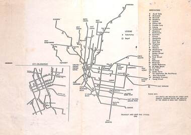 Melbourne Tram Museum
Map, "Tramway and Light Rail System - with substations", 1988
Map or Plan, titled "Tramway and Light Rail System", showing the routes as in 1988 with substations located and their abbreviation and name. Has an enlargement for the city area. Also locates depots and the location of the Carlton Centre control centre Not known who prepared the plan.trams, tramways, map, substation, depots, power supply, electrical engineering -
 Warrnambool and District Historical Society Inc.
Letter Book 3, 1901 - 1908, 1900
This letter book has letters, plans and maps and dates from 1901 to 1908. It came from the office of John William Crawley, Junior, an engineer, architect and surveyor in private practice in Warrnambool and also the engineer for the Shire of Warrnambool from 1895 to 1935. His father, brother and son were also engineers and worked in that capacity or as the Shire Secretary for the Shire of Warrnambool, with the Crawley family recording a total of 132 years of service to the Shire. The letter book was passed on to John Crawley’s son, Rolf, engineer for the Shire of Warrnambool from 1935 to 1968. The letter book then came into the possession of Michael Hand who took over the private surveying business of Rolf Crawley in Warrnambool. The Warrnambool and District Historical Society has acquired the letter book, one of several Crawley ledgers, from the Michael Hand estate. The Shire of Warrnambool existed from 1863 to 1994. This letter book is of considerable significance as it contains maps, plans and letters produced by John William Crawley Junior, the engineer for the Shire of Warrnambool for 40 years. It will be very useful for research. This is a hard cover letter book of 717 pages. It has a black cover with brown leather binding on the cover edges and spine. The leather is worn away in places. The letter book contains an alphabetical index, handwritten letters, sketch plans and maps. There is a mauve stamp on the inside front cover. ‘3’ ‘Letter Book 1901 to 1908’ ‘Letter Book J.Wm. Crawley’ ‘Rolf L. Crawley, Civil Engineer, Drainage and Water Supply Engineer, Licensed Surveyor, Registered Architect, Warrnambool’ john william crawley junior, warrnambool, rolf crawley, warrnambool, history of warrnambool -
 Warrnambool and District Historical Society Inc.
Letter book 14, 1923
This letter book contains letters, sketch maps and plans and dates from 1923 to 1926. It came from the office of John William Crawley, Junior, an engineer, surveyor and architect in private practice in Warrnambool and also the engineer for the Shire of Warrnambool from 1895 to 1935. His father, brother and son were also engineers, working in that capacity or as the Shire Secretary for the Shire of Warrnambool, with the Crawley family recording a total of 132 years of service to the Shire. The Shire of Warrnambool existed from 1863 to 1994. This letter book was passed on to John Crawley’s son, Rolf, the engineer for the Shire of Warrnambool from 1935 to 1968. It then came into the possession of Michael Hand who took over the private surveying business of Rolf Crawley in Warrnambool. The Warrnambool and District Historical Society acquired the letter book, along with several other Crawley ledgers, from the estate of Michael Hand.This letter book is of considerable significance as it contains letters, maps and plans drawn up by John William Crawley, an engineer and surveyor in private practice in Warrnambool and the engineer for the Shire of Warrnambool for 40 years. It will be useful for researchers. This is a brown hard cover letter book of 1010 pages, with brown binding on the corners of the cover and on the spine. The cover is cuffed and torn. There is gold lettering on the spine. The book contains handwritten letters, maps and plans and an alphabetical index at the front, The pages are water-stained. There is a mauve stamp on the first page.‘Letter Book 1923 to 1926’ ‘J. Wm. Crawley Shire Hall Warrnambool (Private)’ ‘Rolf L. Crawley Civil Engineer, Drainage and Water Supply Engineer, Licensed Surveyor, Registered Architect, Warrnambool’ john william crawley junior, warrnambool, rolf crawley, warrnambool, shire of warrnambool -
University of Melbourne, Burnley Campus Archives
Plan, School of Horticulture - Burnley, 1957
(1) Plan of whole site dated 22.05.1957, marked into different areas by letter with key for size of area, proposed new buildings, existing permanent and temporary buildings. New inclusion of about 1 acre hand drawn (behind Administration Building). "Burnley Areas," handwritten on reverse. (2) Handwritten notes (T.H. Kneen): Table with area, size sq ft, size acres, of Stockman's Cottage, Grazing area, Ornamental, New extension, Crops - Controlled by School (Plant Breeding, Agrostology, Biology, Egg-laying Competition) - Controlled by Other Branches. From T.H. Kneen files. On same plan as B91.0484 (original) and B91.0476.t.h. kneen, burnley gardens, burnley school of horticulture, stockmans' cottage -
University of Melbourne, Burnley Campus Archives
Plan, Swan Street Entrance. Also see B15.0352, 1988-1998
(1) 1 coloured and 2 copies, hand drawn , and 4 tracing paper sketches. Concept and Drawing by Steve Mullany, Lecturer V.C.A.H. Burnley, 09.12.1988. (2) 2 copies on tracing paper, original on paper with some additional notation and 3 copies of Landscape Plan by Steve Mullany 3 Feb 1989. (3) Photocopy of Project Eden, Swan Street, Richmond - Landscape Plan LA2 Project No 682 by Mark Mc Wha Pty. Ltd. Nov 1997. Includes Irrigation and Plant Schedule. (4) Coloured, Swan St Frontage Planting Scheme by P. Tulk for AMRAD 19.2.1998. -
 Orbost & District Historical Society
plans, June 15 1931
The Rising Sun Reef first opened, at Bonang in 1868.– at Goongerah Creek south west of Bonang. William Hunter (1893-1971), resident of Tatura and Mallacoota was a soldier, surveyor and amateur naturalist. This document is a useful research tool.Plans and application for the "Rising Sun Goldmine". Tery are on foolscap sized white paper with black text. hunter-william gold-mining rising-sun-goldmine bonang -
 Glen Eira Historical Society
Caulfield Subdivision
Photocopy of sub division plan in Caulfield North of property owned by James Gill, dated 1864caulfield north, land subdivision, gill, james -
Federation University Historical Collection
Plans, Mt Helen Library Refurbishment Plans, 2008, 08/2008
Six pages of plans for the E.J. Barker refurbishment, including the creation of the Geoffrey Blainey Research Centre. e.j. barker library, library, geoffrey blainey research centre, plans -
Federation University Historical Collection
Photograph, Simone Byrne and Keith Boast, c1998
Photographic portrait of Simone Byrne and Keith Boast, members of Ballarat School of Mines Planning and Marketing.keith boast, simone byrne -
 Phillip Island and District Historical Society Inc.
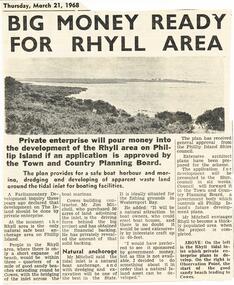
Newspaper Clipping, Rhyll Development, 21/3/1968
Collection of newspaper clippings from Scrap Book 1960 - 1973Private enterprise seek approval of Town & Country Planning Board for major development of Rhyll Inlet.rhyll development, town & country planning board, private enterprise, newspaper clipping, jean jamieson -
 Phillip Island and District Historical Society Inc.
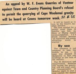
Newspaper clippings, 22/08/1968
Local history involving P.I. Historical Society. Collection of newspaper clippers in scrap book dated 1960 - 1973re Appeal Evans Quarries v T & C Planning refusal quarrying Woolamai granitelocal history, newspapers, quarries, phillip island, cape woolamai granite, jean jamieson, w f evans quarries ventnor -
 Greensborough Historical Society
Manuscript, Late Thoughts! by June Roberts, 1958-1978
This was prepared by June Roberts with assistance from Grace Cavill. Written in 1978 it includes details of Greensborough's Main Street from circa 1958-1978.Describes the locations of the Main Street traders in the 1950s. Also mentions the efforts needed to replace the Plenty River footbridge after it was washed away in a flood.A 3 page typed manuscript and a hand drawn plan of Greensborough shopping area based on the document.Sept 78 in blue biro on front page.main street shops, tom vickers, hume street, griffiths haberdashery, popes, flintoff street, plenty river bridge, stubleys hardware, stan ashleys menswear, hume street residences, rob willett, ashril theatre -
4th/19th Prince of Wales's Light Horse Regiment Unit History Room
Lesson Plans, Armoured Centre Gunnery Wing: T50 Turret, abt 1978
A photo copy of the lesson plans for the Gunnery Course covering the T50 Turret, contained in a manila folder.t50 turret, lesson plans