Showing 6702 items
matching river
-
 National Wool Museum
Shoes
Australian mens shoes from the formal uniform for the Sydney 2000 Olympic Games. Manufactured by Rivers Shoes.fashion, woolmark company rivers shoes, sport, the woolmark company 2000 australian olympic display - exhibition (21/12/2001 - 24/05/2002) -
 Kiewa Valley Historical Society
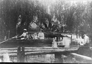
Photo - Water Wheel and Punt on the Kiewa River - Tangambalanga Homestead
In early times, Homesteads were part of pastoral runs many of which had frontage onto a river.Tangambalanga Homestead, on the Kiewa River, was subdivided in 1862 from T. Mitchell to Thomas BrownBlack and white shiny photo with women and children in a boat on 'flood' waters and a woman on the bank near a footbridge or jetty. The ladies are wearing hats, long skirts and blouses. In the background there is a large water wheel and trees. This photo is published on Page 19 of 'A History of the Kiewa Valley' by Esther Temple and David Lloyd.tangambalanga homestead, water wheel on the kiewa river, punt on the kiewa river -
 Greensborough Historical Society
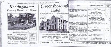
Magazine - Advertisement, Greensborough Hotel Advertisement 1933-34, 1933-1934
An advertisement for Greensborough Hotel in the town of "Greensborough, picturesque township on the Plenty River, 13 miles from Melbourne."Photograph show the "new brick building with all modern conveniences'. Greensborough in the 1930s was a popular spot for picnics and holidays.2 pages from a Victorian Railways travel journal. Advertisement for Greensborough Hotel 1933-34. Photocopy from original journal.greensborough hotel, greensborough -
![View of the Township of Omeo / [by] Nicholas Caire, circa 1876](/media/collectors/550653872162f11fb04854aa/items/57830e80d0cdd1176c4335ca/item-media/57830eecd0cdd1176c43dd40/item-fit-380x285.jpg) Kew Historical Society Inc
Kew Historical Society IncPhotograph, Anglo-Australasian Photographic Company, View of the Township of Omeo, c. 1876
Nicholas Caire was born on Guernsey in the Channel Islands in 1837. He arrived in Adelaide with his parents in about 1860. In 1867, following photographic journeys in Gippsland, he opened a studio in Adelaide. From 1870 to 1876 he lived and worked in Talbot in Central Victoria. In 1876 he purchased T. F. Chuck's studios in the Royal Arcade Melbourne. In 1885, following the introduction of dry plate photography, he began a series of landscape series, which were commercially successful. As a photographer, he travelled extensively through Victoria, photographing places few of his contemporaries had previously seen. He died in 1918. Reference: Jack Cato, 'Caire, Nicholas John (1837–1918)', Australian Dictionary of Biography.An original, rare photograph from the series 'Views of Victoria: General Series' by the photographer, Nicholas Caire (1837-1918). The series of 60 photographs that comprise the series was issued c. 1876 and reinforced a neo-Romantic view of the Australian landscape to which a growing nationalist movement would respond. Nicholas Caire was active as a photographer in Australia from 1858 until his death in 1918. His vision of the Australian bush and pioneer life had a counterpart in the works of Henry Lawson and other nationalist poets, authors and painters.‘View of the township of Omeo’ : Views of Victoria (General Series) No.44 : Albumen silver photograph | Photo on card with Title and Description on reverse | Mounted 24 x 30 cm; Photo 12 x 17 cm.On Reverse: ‘The subject of this illustration is the most remote Township in the Colony of Victoria, being about 250 miles distant from Melbourne. It is situated on the Australian Alps, near Mt. Livingstone. The bed of the River, which is seen on the right-hand side of the picture, is one of the sources of the Mitchell River, which empties itself in the Gipps Land Lakes. This Township is frequently covered with snow in winter time, owing to its being several thousand feet above the level of the sea.’ nicholas caire (1837-1918), omeo (vic), gippsland, mount livingstone, australian alps -
 Kiewa Valley Historical Society
Calendar 2008
Brief history of the SECV construction town of Bogong which became a tourist town."Memories of Bogong Calendar 2008" Photographs of the physical environment. Front cover has a photograph of a person standing in a river. A short history of 'Bogong 1957-1963' and 'Come visit Bogong Village' a 'celebration of Bogong Village's environment'. 12pp with a hole (to hang up) in the centre bottombogong, calendar, tourism, bogong village, secv, kiewa hydro electric scheme -
 Bendigo Historical Society Inc.
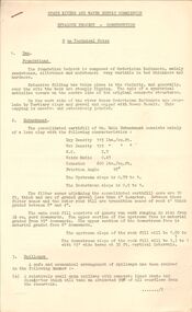
Document - STATE RIVERS AND WATER SUPPLY COMMISSION : EPPALOCK PROJECT - CONSTRUCTION
State Rivers and Water Supply Commission headed six page document, stapled. Subtitled: ' Eppalock Project - Construction. Some Technical Notes.' Information typed under subheadings: Dam, Embankment, Spillways, Outlet works, proposed hydraulic driven pumps, road deviations. Undated.state infrastructure, water supply, coliban system, state rivers and water supply commission. coliban system. eppalock. -
Port Melbourne Historical & Preservation Society
Photograph - Various wharf/pier locations, 1920 - 1922
Original photos. Eighteen loose photos in separate box . Charles Wynn Kiver Allison M.I.E.A.. Namely the New Pier (Princes), Railway Pier, Williamstown, Centre Pier in Victoria Dock, and the Interstate Swinging Basin (near Charles Grimes Bridge) in Yarra River 1920spiers and wharves - miscellaneous, piers and wharves - princes pier, charles wynn kiver allison, victoria dock -
Port Melbourne Historical & Preservation Society
Map - Photographic copy, Unidentified map of Sandridge, c. 1866
Photographic copy of an unidentified (Cox?) Sandridge map 1866 or later, with portions of West Melbourne, Emerald Hill and the Bend. Indicates bay and river soundings 'taken by Commander COX in 1866'. Original appears to have been torn and repaired; resultant lines whited out on copy.Fold lines have been whited out on back; '52'piers and wharves, transport - railways, built environment, maritime, beacons, sandridge lagoon, batteries - defensive, commander cox -
 Bendigo Historical Society Inc.
Document - Various writings by John Ellison
Writings on various topics. Some are glued inside a notebook. Two others are on loose pages. The notebook has a view of a lake/river with several small villages on the banks. location unknown. Topics are: "The Australian Aboriginals", ' The Great Pastland Movement", Problem of Urban Planning" and "the Plea of Youth".On the cover and on the first page a stamp: L.J. Ellison A.I.M.A.australian aborigines, pastoralist movement, urban planning -
Unions Ballarat
In step with Sturt (Don Woodward Collection), Swan, Keith et al, 1979
The book, targeted at school students, covers the years of Sturt's three expeditions. The authors question Sturt's capability as a surveyor and his leadership.Australian history.Graphic book; 115 pages. Dustjacket: plastic covering; brown and white background; black and white map of Sturt's journey along Murrumbidgee and the Murray River; black, gold and white lettering; authors' names and title. Cover: white and black lettering; authors' names and title.btlc, ballarat trades and labour council, ballarat trades hall, sturt, charles, history - australia, australia - explorers -
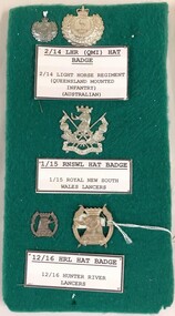 8th/13th Victorian Mounted Rifles Regimental Collection
Badge - LH regimental badges
Five metal badges mounted on green fabric board : 2/14 Queensland Mounted Infantry (QMI) hat and lapel ; 1/15 Royal New South Wales Lancers (RNSWL) hat badge ; 12/16 Hunter River Lancers (HRL) hat and lapel.light horse, new south wales, lancers -
 Kew Historical Society Inc
Photograph - Flood, Zig-Zag, Kew, 1924
Henry Beater Christian (1886-1962) , was a descendant of one of the earliest settler families in Kew. Employed at the Kew Asylum as a 'public servant', he was a skilled amateur photographer, photographing numerous scenes in Kew and on his travels around Victoria. The majority of his photographs date from 1916 to 1929. His finest photographs are housed in two photograph albums. Digital copy of a photograph from page 5 of the 47-page photograph album containing 261 gelatinous silver images, loaned by Diane Washfold with permission given to digitise and hold a copy in our collection. This is a photograph of a section of the river at Kew during a flood in January 1924."Flood / Zig-Zag Kew / 1.24"henry beater christian (1886-1962), landscape photography, kew (vic.) — yarra river, christian-washfold collection, photograph albums, floods -- yarra river -- kew (vic.) -
 8th/13th Victorian Mounted Rifles Regimental Collection
Photograph
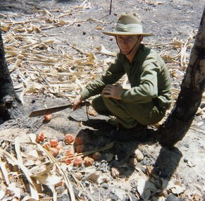
In 1988, as part of a Defence of Mainland Australian policy, defence of facilities of strategic importance in northern Australia were allocated to Army Reserve units. ‘A’ Squadron was allocated the defence of Tindal Air Force base located 15 KM outside Katherine in Northern Territory. Consequently the Squadron deployed on Exercise ‘Northern Explorer’ to gain first-hand knowledge of operating conditions for mounted and dismounted patrolling in the area.Lance Corporal R. Van De Velde, ' A ' Squadron 8/13 VMR during Exercise ' Northern Explorer' September 1988. LCpl Van De Velde has a collection of Pandamus Palm nut prematurely ripened by fire near King River Northern Territory. -
 8th/13th Victorian Mounted Rifles Regimental Collection
Photograph
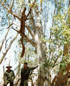
In 1988, as part of a Defence of Mainland Australian policy, defence of facilities of strategic importance in northern Australia were allocated to Army Reserve units. ‘A’ Squadron was allocated the defence of Tindal Air Force base located 15 KM outside Katherine in Northern Territory. Consequently the Squadron deployed on Exercise ‘Northern Explorer’ to gain first-hand knowledge of operating conditions for mounted and dismounted patrolling in the area.Colour photograph of Captain C. Carrington, earing hat, and Sergeant Koschel of ' A ' Squadron 8/13 VMR during Exercise " Northern Explorer." Flood debris caught high in tree branches indicate water level during wet season on Ferguson River, Northern Territory. -
![Hand-Drawn Map Centred on Myrtleford by Frank Lebbell Frost [ca 1915-1918]](/media/collectors/51d110e42162ef12e06aa06b/items/51fb0bb72162ef156c79aeee/item-media/52a11c442162ef1f0c9c052b/item-fit-380x285.jpg) Beechworth Honey Archive
Beechworth Honey ArchiveHand-Drawn Map Centred on Myrtleford by Frank Lebbell Frost [ca 1915-1918]
This is one of the maps drawn by Frank L. Frost while he was beekeeping in North-East Victoria. This particular map may be reference in the "Wooden" Diary on page 8.Hand-drawn map centred on Myrtleford, Palmerston, Gapstead Road, the Ovens River and the Myrtleford-Wangaratta Road. Shows locations of flowering eucalypts. Scale is 1 mile to 1 inch. Drawn with black pen and grey lead on paper. Names of towns are marked in red pen. hand drawn, hand-drawn, map, myrtleford, palmerston, gapstead, ovens, beekeeping, frost, beechworth honey -
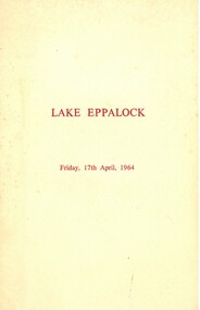 Bendigo Historical Society Inc.
Document - LAKE EPPALOCK OPENING CEREMONY PROGRAM 1964
Cream folded program. On front 'Lake Eppalock, Friday 17th April 1964, printed in brown text. Inside: State Rivers and Water Supply Commission, Ceremony to mark the completion of the Eppalock Dam and Pumping Station and the Eppalock-Bendigo Pipeline, Friday 17th April 1964.bendigo, waterworks, lake eppalock -
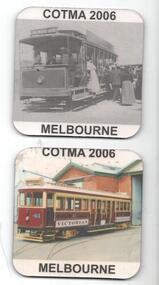 Melbourne Tram Museum
Domestic object - Coaster set, Council of Tramway Museums of Australasia (COTMA), 2006
Set of two drink Coasters, featuring a tramcar image printed onto a foam rubber backing. Tramcars featured are VR St Kilda Brighton tramcar VR41 and NMETL No. 13 at the Saltwater River terminus. Made by the Council of Tramway Museums of Australia for the Melbourne 2006 Conference.trams, tramways, cotma, vr trams, nmetl, souvenirs, tram 41, tram 13 -
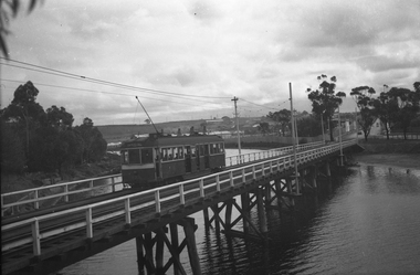 Melbourne Tram Museum
Negative, Wal Jack, 1943-44
Black and white negative, by Wal Jack, of W5 832, showing Special B, crossing the Maribyrnong River Bridge westbound with a number of passengers. The tram only bridge has been duplicated during September 1943. Photo not dated in the Wal Jack album, c1943 - 44trams, tramways, w5 class, special b, maribyrnong river bridge, maribyrnong rd, world war 2, tram 832 -
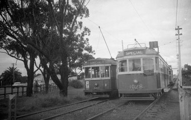 Melbourne Tram Museum
Negative, Possibly Keith Kings, c1960
Black and white negative, by X1 461 and W7 1028 at the western end of Maribyrnong River bridge while on a AETA tour, Fri 31.3.1961. Date from railtourist.com.au VR Tours wiki. Following 1028 is a route 82 car. Photo not in Wal Jack Melbourne album.trams, tramways, maribyrnong river bridge, w7 class, x1 class, aeta, tram 1028, tram 461 -
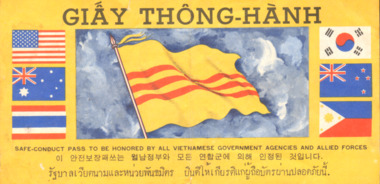 National Vietnam Veterans Museum (NVVM)
Document, Safe Conduct Pass+ Propaganda sheets
Deep yellow in colour with black print. Six flags (USA, Australia, Thailand, Korea, New Zealand and Philippines) on either side of South Vietnamese flag. All other pages are B&W except the last page which has a river scene and pink flower.GIAY THONG-HANH "Safe conduct pass to be honored by all Vietnamese Government Agencies and Allied Forces" / Back signed by Nguyen Van Thienpermissive orders, pass, safe conduct, julian peter mcnamara, mcnamara, australian army, 3794332, trooper, royal australian armoured corps, national service, b squadron, a squadron, 1st armoured regiment -
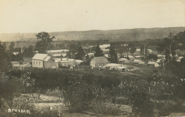 Lakes Entrance Historical Society
Postcard - Bruthen Victoria, 1914
Letter on back written by Bruthen rail survey camp worker dated 28/ 6 /14Sepia toned postcard of view of Bruthen showing R C Church on left Congregational Church centre and Church of England just beyond it, Tambo River in the distance Bruthen Victoria. Also a larger black and white copy plus details of letter on the back of original cardBruthen 1914township, transport, land settlement -
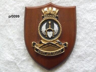 Waverley RSL Sub Branch
Plaque H.M.A.S. Derwent
HMAS Derwent (F22/DE 22/DE 49), named for the Derwent River, was a River class destroyer escort of the Royal Australian Navy (RAN). Commissioned in 1964, the ship operated during the Indonesia-Malaysia Confrontation, and was used for filming of the British drama series Warship. The ship was decommissioned in 1994, and was scutted as an artificial reef after use for ship survivability testsInsignia od H.M.A.S. Derwent on wooden shieldH.M.A.S. Derwenth.m.a.s. derwent -
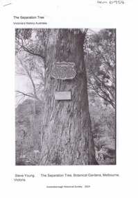 Greensborough Historical Society
Article, The Separation tree, 2019_
The tree was one of two original red river gums that pre-dated European occupation, and was the site where colonists congregated to celebrate the announcement of Victoria's separation from New South Wales on 15 November 1850. It died as the result of vandalism in 2010 and 2013. Saplings of the original are planted around Melbourne, including along the Plenty River Trail in Greensborough3 p. Wikipedia article; photograph of the tree in the Botanical Gardens, Melbourne (before it was vandalised), and copy of the document of separation of the province of Victoria from the Colony of New South Wales, owned by Colin Boucher..separation tree -
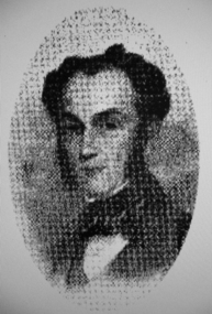 Greensborough Historical Society
Photograph - Digital image, Portrait of Edward Green, 1850c
Portrait of Edward Green. In the 1840s, Edward B. Green ran the mail service between Melbourne and Sydney and owned a parcel of land on the Plenty River. He engaged a surveyor to draw up plans and lay out a township on the slopes overlooking the river, and to mark out small farm holdings on the flats. This small township named after him is now Greensborough.Digital copy of portrait.edward bernard green, greensborough history -
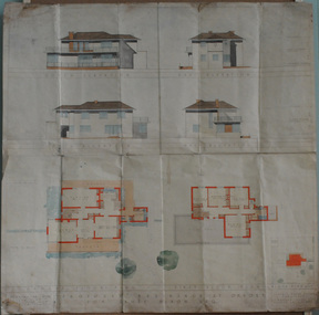 Orbost & District Historical Society
plans, July 1949
These house plans were drawn up for James Nixon. James Nixon was born in Orbost on 15.11.1912. He married Joyce May Thompson on 2.2.1937. He was a well known Orbost identity, serving a record 47 years as a Commissioner on the Snowy River improvement Trust, as well a director of Snowy River Seed and th Bean Board. He died on 21.12.2002.James Nixon, a third generation Nixon, father of Peter Nixon A.O., was an involved and respected Orbost identity. This item is a significant research tool.Architectural plans for a two-storey house with 4 bedrooms to be built on the corner of Gladstone and Tennyson Streets in Orbost. On a white background with coloured drawings ( water colour).nixon-james house-plans architecture -
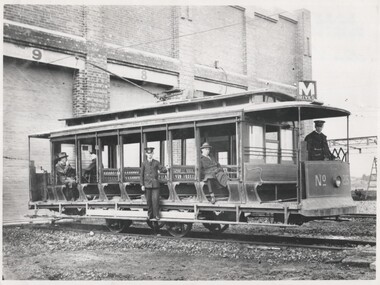 Melbourne Tram Museum
Photograph - Black and White V class 215 at Preston Workshops 1925
Tram originally built for The North Melbourne Electric Tramways and Lighting Co. (NMETL) in 1906 as a straight sill open cross bench tram. Photograph is of the tram body on an un-motored truck or wheel set and has been posed for an official MMTB photograph in 1925, soon after the workshops were completed. It shows the destination of "M River" for Maribyrnong River.Shows the only type of fully open cross bench tram operated by the MMTB. This style was popular as a summer tram in North America. Originally built by Brill (USA) in 1906 and assembled by Duncan and Fraser for the NMETL as Tram No. 14. Taken over by the MMTB in 1922 and given the number 215.Black and White photograph of V class 215 at Preston Workshops 1925.In ink on rear "V class"trams, tramways, v class, preston workshops, tram 215, nmetl, brill, mmtb, uniforms -
 Eltham District Historical Society Inc
Album - Photograph, J.A. McDonald, Eltham-Yarra Glen Road, 18 Oct. 1956
Eltham-Yarra Glen Road Proposed crossing of Plenty River at Lower Plenty. Floods 18th October 1956.Record of various Shire of Eltham infrastructure works undertaken during the period of 1952-1962 involving bridge and road reconstruction projects, sometimes with Eltham Shire Council Project Reference numbers quoted. It was during this period that a number of significant improvements were made to roads and new bridges constructed within the shire that remain in place as of present day (2022). In many situations, the photos provide a tangible visible record of infrastructure that existed throughout the early days of the Shire. The album was put together by or under the direction of the Shire Engineer, J.A. McDonald.infrastructure, road construction, shire of eltham, bridge construction, eltham-yarra glen road, 1956-10-18, floods, floodwater, lower plenty, plenty river -
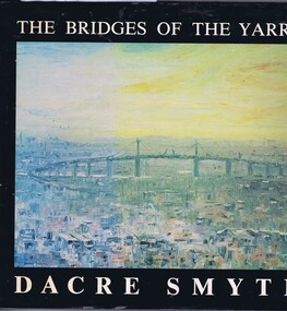 Greensborough Historical Society
Book, The Bridges of the Yarra: a book of paintings, poetry and prose, by Dacre Smyth, 1980_
Unpaged, dustjacket, colour illustrationsyarra river, bridges, dacre smyth, poetry, paintings -
 Greensborough Historical Society
Article - Article, Journal, E. G. Ritchie, Melbourne's water supply undertaking, by E. G. Ritchie, 1934
An historical account of the development of Melbourne's water supply, including the Yarra and Plenty Rivers and Yan Yean and Maroondah Reservoirs.4 p., photocopy of article.melbourne water, mmbw, maroondah aqueduct, yan yean reservoir -
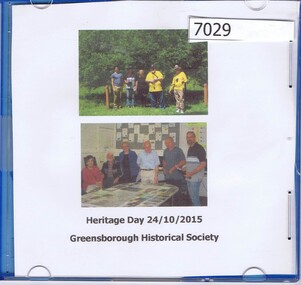 Greensborough Historical Society
CD-ROM, Greensborough Historical Society Heritage Day 2015, photographs by Marilyn Smith, 24/10/2015
Photographs of participants in Plenty River Trail walk led by Noel Withers 24/10/2015, and at following BBQ. CD-ROM containing 65 photographs, with written background notesplenty river trail, greensborough historical society