Showing 7072 items
matching snowy-river
-
 Bacchus Marsh & District Historical Society
Map, Maddingley Township, Parish of Parwan, circa 1890s
Maddingley is a locality or township within the broader township area of Bacchus Marsh. This map is not dated. However features in Maddingley which appeared in the 1880s and 1890s are present in the map, These include the Bacchus Marsh Railway Station and the Bacchus Marsh Showgrounds. The main residential and commercial area of Maddingley is shown on this map in an area bounded by Bacchus Street, Barry Street, Griffith Street and Maddingley Road. Other streets visible are Franklin Street, Inglis Street, Labilliere Street, McCrae Street, Moore Street and part of Station Street.A single page paper map showing land allotments, streets, rivers, creeks, park lands, the railway line and Bacchus Marsh railway station in the township of Maddingley. The map is pasted into a bound volume containing 76 maps or plans in total. bacchus marsh victoria maps, maddingley victoria maps, land use, maddingley victoria history -
 Lakes Entrance Historical Society
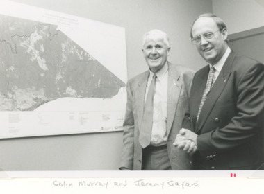
Photograph, Lakes Post Newspaper, East Gippsland Catchment and Land Protection, Lakes Entrance Victoria, 1/12/1995 12:00:00 AM
Black and white photograph of Colin Murray and Jeremy Gaylard at the East Gippsland Catchment and Land Protection meeting during inspection of the area of Lakes Entrance Victoria. Also a colour photograph of upper reaches of the Nicholson River during a dry season environment, wetlands, rivers, conservation -
 Lakes Entrance Historical Society
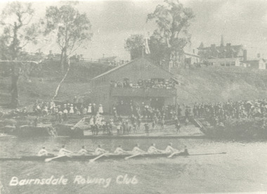
Photograph - Rowing Club at Bairnsdale Victoria, 1902
Black and white photograph showing rowing skull with eight crew on Mitchell River large crowd of onlookers on bank during official opening of Rowing Club at Bairnsdale Victoria. Also a small black and white postcard showing same eventBiarnsdale Rowing Clubsports, events, rivers -
 Lakes Entrance Historical Society
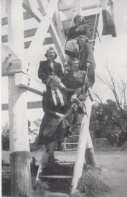
Photograph - St Annes Girls School Teachers, 1949 c
Black and white photograph of teachers from St. Annes girls school Sale Victoria Miss Rivers, Miss Turner Miss Beadle, Miss Bailing, Front Miss Carlyle posing on steps at Jemmys Point lookout Kalimna Victoria tourism, people, school teachers -
 Eltham District Historical Society Inc
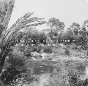
Album - Photograph, J.A. McDonald, Eltham-Templestowe Road, c. 1957
Site for bridge over Yarra River looking from Eltham bank.Record of various Shire of Eltham infrastructure works undertaken during the period of 1952-1962 involving bridge and road reconstruction projects, sometimes with Eltham Shire Council Project Reference numbers quoted. It was during this period that a number of significant improvements were made to roads and new bridges constructed within the shire that remain in place as of present day (2022). In many situations, the photos provide a tangible visible record of infrastructure that existed throughout the early days of the Shire. The album was put together by or under the direction of the Shire Engineer, J.A. McDonald.infrastructure, road construction, shire of eltham, bridge construction, bridge street bridge, 1957, fitzsimons lane bridge, eltham-templestowe road -
 Greensborough Historical Society
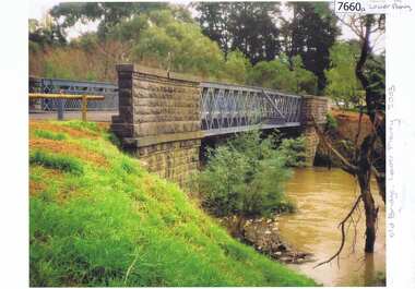
Photograph - Photograph (Copy), Anne Paul, Old bridge, Lower Plenty 2003, 2003_12
Two views of the old bridge over the Plenty River in Lower Plenty.2 colour photographs printed on paper, handwritten captionslower plenty, plenty river, floods, edward willis drive lower plenty -
 Greensborough Historical Society
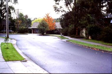
Slide - Photograph, John Ramsdale, Lower Plenty houses: Slide 79, 1990s
Photograph shows a residential street in Lower Plenty - the Plenty River is behind.Part of the John Ramsdale collection of slides and audio visual material.Colour photograph scanned from slide.No caption. Printed maker's mark on slide "Kodak Kodachrome Slide"lower plenty, plenty river, residential development -
 Greensborough Historical Society
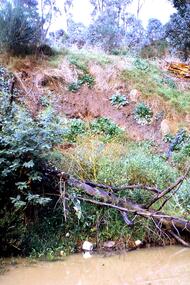
Slide - Photograph, John Ramsdale, Poor riverbank management: Slide 62, 1990s
Photograph shows poor riverbank management along the banks of the Plenty River.Part of the John Ramsdale collection of slides and audio visual material.Colour photograph scanned from slide.No maker's marks. No caption on slide.plenty river -
 Greensborough Historical Society
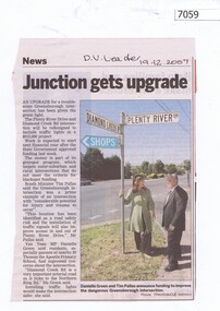
Newspaper Clipping, Junction gets upgrade, 19/12/2007
Article on the upgrade of the Diamond Creek Road and Plenty River Drive intersection. Black and white text, colour imageplenty river drive greensborough, diamond creek road greensborough -
 Greensborough Historical Society
Photograph - Digital image, Marilyn Smith, Partington's Flat, 16/08/2015
Partington's Flat. These photos show the Plenty River Trail at Partington's Flat.Digital copy of colour photographspartingtons flat, plenty river trail -
 Tatura Irrigation & Wartime Camps Museum
Photograph, 1936/02
Photo taken by the photographer for Victoria State Rivers and Water Supply CommissionMedium sized black and white photograph. Eildon Reservoir spillway / Concrete structure centre / rock and earth fill dam wall top half / round concrete tower left midway along wall bank.goulburn, irrigation, photo, victoria state rivers and water supply commission, eildon, eildon weir -
Tatura Irrigation & Wartime Camps Museum
Photograph, 1936
Photo taken by the photographer for Victoria State Rivers and Water Supply CommissionMedium sized black and white photograph. Eildon Weir spillway / Concrete structure of terraced steps and pylons supporting floodgates / rectangular tower on right / Dam water beyond at top of picture.goulburn, irrigation, photo, victoria state rivers and water supply commission, eildon, eildon weir -
Tatura Irrigation & Wartime Camps Museum
Photograph, 1936
Photo taken by the photographer for Victoria State Rivers and Water Supply CommissionMedium sized black and white photograph. Eildon Reservoir dam wall / rock and earth fill wall from above / round concrete tower lower left / water above right / tree covered hill topgoulburn, irrigation, photo, victoria state rivers and water supply commission, eildon, eildon weir -
Tatura Irrigation & Wartime Camps Museum
Photograph, 1936
Photo taken by the photographer for Victoria State Rivers and Water Supply CommissionMedium sized black and white photograph. Eildon Reservoir overall picture - Original reservoir and dam / rock and earth fill dam wall and construction huts left of centre / trees foreground / tree covered hills top left and across top / dam water / with leisure craft near wall.goulburn, irrigation, photo, victoria state rivers and water supply commission, eildon, eildon weir -
Tatura Irrigation & Wartime Camps Museum
Book, Water into Gold, 1965
Depicts pioneers of irrigation, Chaffey Bros., and story of irrigation on the Murray RiverBlue soft cover, depicting aerial photo of farmland, white lettering.water into gold, irrigation, hill e, tatura, books, history, local, rural, industry -
 Tatura Irrigation & Wartime Camps Museum
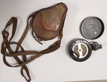
Instrument - Compass and case
Used by John Burke at the State Rivers Tatura in the 1960 - 1970's.Compass: black and silver rimmed round container with removable lid. Bottom section has a clear glass with black rim covering the compass pointer and directions. Has 8 gold screws in black rim. Attached to rim is a hinged section with middle section see through. Opposite hinged section is another hinged section with sight on it. On outside rim of container under second hinged piece, is a black metal ring for holding. Bottom of the container has a flanged circle which attaches to a stand. Case: is tan leather with stitching around all edges. Two pieces, one large which holds the compass and the other is joined to bottom piece to form a lid. A leather strap is joined to the large section to hold the lid down and to make a carrying strap. Inside is red felt.compass, john burke, state rivers tatura -
 Malmsbury Historical Society
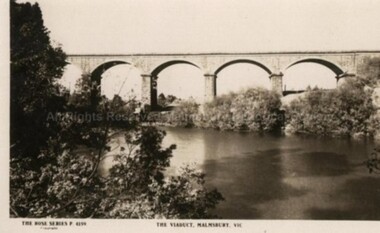
Postcard (Item), "Postcard Of The Viaduct Malmsbury, Rose Series P4159", Malmsbury c1923
Associated with - Rose Series P4159 Buildings - "Viaduct, Coliban River, Gardens" -
 Charlton Golden Grains Museum Inc
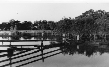
Photograph
Flooded Billabong Cadgow's Dairy in the bend of the Avoca River Oct 1975Black and white photograph of flooded billabong.flood, charlton -
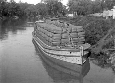 Port of Echuca
Functional object - Insider Barge, Ada, 1899
The Ada is a barge made of a composite of wood and iron. it was built at Echuca in 1899 to carry wool and cargo from station properties on the Murray and Murrumbidgee rivers to the Port of Echuca . It was towed along the river by paddle steamers, mainly The PS Pevensey. The Ada could carry 350 tons of cargo and was originally owned by The Permewan and Wright, Murray Shipping Co. In the late 1930s she was bought by the Evans Brothers' Red Gum Sawmill. Two bulkheads were removed to enable the logs, to be placed inside and transported to the mills. Road transport overtook the use of the river barges, and The Ada was left abandoned on the banks of the Murray River opposite the sawmill until it was purchased by the Port of Echuca in 1974 and refloated in 1979.A barge with a composite hull of steel and timber which was built in 1898ADA signage on port and starboard bow -
 Melbourne Tram Museum
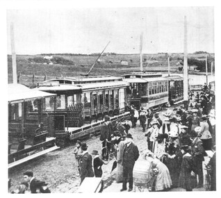
Photograph - NMETL trams at Saltwater River, c1906
The photograph is of a group of two trams and two trailers of The North Melbourne Electric Tramways and Lighting Co. (NMETL) at the Saltwater River terminus for a major event. The river is now the Maribyrnong. Possibly at the time of the opening or soon after as the road surface alongside the trams is unformed, just ballast.Yields information the NMETL trams possibly soon after opening in 1906.Black and white photograph with notes on the rear.In pencil "No 14, 064". tramcars, tramways, v class, u class, trailers, nmetl, saltwater river, maribyrnong river -
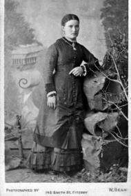
 Orbost & District Historical Society
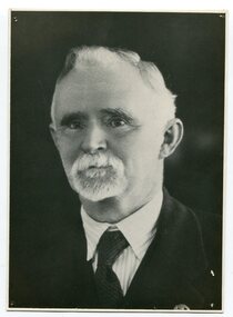
black and white photograph, C1877
This is a photograph of Mr Harry Felix . Richardson who selected land at Bete Bolong in 1887. He married Elizabeth Wardle in 1893 and had no children. Harry Richardson was a keen angler, rifle shooter and cricketer and was very much involved with the local community. With his brother, Alan, he had pioneered the move to the Snowy in 1878. He died in Bairnsdale , aged 83, in 1941.Harry Richardson was a prominent and active member of the Orbost community in the late 19th and early 20th centuries.A black / white portrait photograph of a man with wavy hair, a small white beard and moustache. -
 Greensborough Historical Society
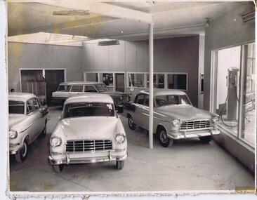
Photograph - Digital Image, Stubley Garage car sales room, 1960_
Stubley Garage car sales room circa 1960. The Stubley Group began in 1946 when Purcell Stubley purchased a site with petrol bowsers in Main Street from 'Snowy' Jessop. In 1948 Purcell began building the new Stubley Motors, working round the old site to keep the business operating. It was completed in 1951. The Group expanded into a Holden dealership in the 1960s.Digital copy of black and white photographpurcell stubley, stubley motors, stubley group greensborough -
 Greensborough Historical Society
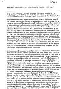
Article - Newspaper Clipping (copy), Jas Blackburn, The locality of Batman's Treaty with the Port Phillip natives, 09/01/1886
Text of a paper read before the Historical Society of Australia by Jas. Blackburn in 1886. Discusses Batman's Treaty with the Port Phillip traditional owners and the possible site of the signing - on the east side of the River Plenty, NW of Eltham andd 3 miles above the junction of the Plenty with the Yarra River.6p. text.john batman, batman's treaty, port phillip district, plenty river -
 Orbost & District Historical Society
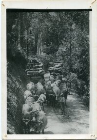
black and white photograph, late 19th - early 20th century
This is a photograph of bullock teams on the Cann Road. out of Cann River, East Gippsland.This is a pictorial record of transport in the mid 18th - early 19th century. Bullock teams could travel in country inaccessible to larger horse - drawn carts or wagon.A black / white photograph of two bullock teams travelling side by side along a bush road.transport-bullocks cann-river -
 Marysville & District Historical Society
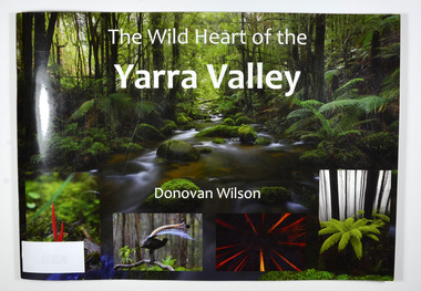
Book, The Wild Heart of the Yarra Valley
A pictorial book of the flora, fauna, rivers, waterfalls and rainforest in the Upper Yarra ValleyPaperback. Front cover has a main photograph of a creek running through a forest. There is also four smaller photographs. They are of a Red Coral Fungi, a Superb Lyrebird, a night time view looking upwards in a grove of trees and a view of a Soft tree fern. The back cover has a photograph of a Superb Lyrebird.yarra valley, upper yarra valley, flora, fauna, photography, rivers, waterfalls, rainforest, nature, donovan wilson -
 Marysville & District Historical Society
Book, The Wild Heart of the Yarra Valley
A pictorial book of the flora, fauna, rivers, waterfalls and rainforest in the Upper Yarra ValleyPaperback. Front cover has a main photograph of a creek running through a forest. There is also four smaller photographs. They are of a Red Coral Fungi, a Superb Lyrebird, a night time view looking upwards in a grove of trees and a view of a Soft tree fern. The back cover has a photograph of a Superb Lyrebird.yarra valley, upper yarra valley, flora, fauna, photography, rivers, waterfalls, rainforest, nature, donovan wilson -
 Greensborough Historical Society
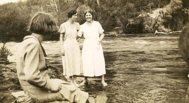
Photograph - Digital image, Myrtle McLaughlin and friends 1935, 1935_
Photograph of Myrtle McLaughlin, Ethyl Bradbury and Dorothy Curtis in 1935. Taken by the river.. The collection contains photographs of friends and relatives from the Greensborough and Eltham areas.Digital copy of black and white photograph.myrtle mclaughlin, ethyl bradbury, dorothy curtis -
 Greensborough Historical Society
Photograph - Digital Image, Mary Mitchell, 1882c
Mary Mitchell and the Mitchell family lived in Hailes Street on a property that went to the river.Digital copy of black and white studio photograph.mary mithcell, mitchell family -
Tatura Irrigation & Wartime Camps Museum
Water Wheel Accuracy Tester, Late 1900s
Used by State Rivers and Water Supply Commission prior to their privatisation about 1990.A clear tube with sand inside - similar to an egg timer. Used to measure the accuracy of water wheels over a half minute or less. Measurements marked on outside and related to one revolution. The blue scales relate to small meter outlets(wheels), yellow scales related to large meter outlets(wheels).Figures of rates relating to measurement of water in one revolution.irrigation, victoria state rivers and water supply commission, water wheel -
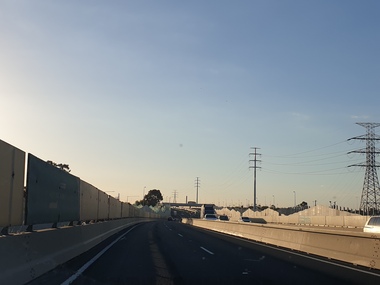 Ballarat Heritage Services
Photograph, Views of the Westgate Bridge, 29/11/2022
The Westgate Bridge spans the Yarra River giving access to Melbourne from the West. westgate bridge, melbourne, road, bridge