Showing 10531 items
matching land
-
 Bendigo Historical Society Inc.
Document - MISS G ALICE JONES COLLECTION: ACCOUNT
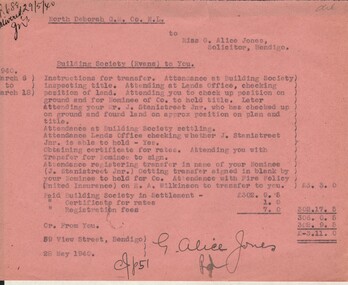
North Deborah G. M. Co. N. L. to Miss G. Alice Jones. Pink paper dated March 6 to 18 1940 and 28 May 1940. Re Building Society (Evans) to You. Account details work and expenses involved in the transfer of land. "R688 delivered 29/5/40" written in the top left corner. Cost £3.11.0.miss g alice jones - solicitor - account, north deborah g m co n l, building society (evans), mr j stanistreet jnr, united insurance, h a wilkinson -
 Bendigo Historical Society Inc.
Document - MISS G ALICE JONES COLLECTION: ACCOUNT
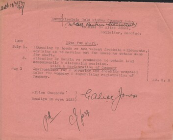
North Virginia Gold Mining Company N. L. (McColl Rankin & Stanistreet) to Miss G. Alice Jones. Pink paper dated July 1, 3 and Aug 1, 1933. Costs involved in procedure to obtain lease of land for shaft and perusing and checking proposed rules for company & supervising registration of company. Cost £2.2.0. Deld 19/9/33 GAJ.miss g alice jones - solicitor - account, north virginia gold mining company n l, mccoll rankin & stanistreet, mr leeds, mr rankin -
 Orbost & District Historical Society
book, Orbost Golf Club, 2006
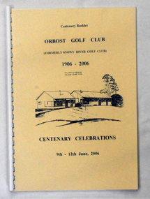
This book was produced as part of the centenary celebrations in 2006. In 2006 Orbost Golf Club celebrated its’ Centenary having originally been formed as the Snowy River Golf Club and played on private land near the banks of the Snowy River just to the south of town. In the 1930’s the Golf Club relocated to its present site and was renamed Orbost Golf Club. The land was shared by the Show grounds and Racing Club. Orbost Golf Club later acquired the land outright to provide a permanent home for golfers in Orbost and surrounding district.This is a local history book.A 38 pp spiral bound book titled Orbost Golf Club Centenary Booklet 1906-2006 Centenary Celebrations 9/12 2006. The front cover is cream and has a black line sketch of the old club house at Orbost Golf Club.recreation orbost-golf-club -
 The Beechworth Burke Museum Research Collection
Card (Series) - Index Card, George Tibbits, 14 William Street Beechworth (cnr Last St), 1976
George Tibbits, University of Melbourne. Faculty of Architecture, Building and Town & Regional PlanningIndex system that support the research for Beechworth : historical reconstruction / [by] George Tibbits ... [et al]Arranged by street names of BeechworthEach index card includes: street name and number of property, image of property, allotment and section number, property owners and dates of ownership, description of the property according to rate records, property floor plan with dimensions.beechworth, george tibbitsbeechworth, george tibbits -
 Halls Gap & Grampians Historical Society
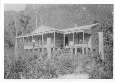
Photograph - B/W, C 1917
Land owned by William & Matilda Thompson. They purchased some disused shearers' quarters, consisting of six rooms, and in 1917 moved the building onto their land to provide a home. Mrs. Thompson had only recently retired after being the manageress of "Bellfield" for seven years. They named their house "Norval". Norval. Front view of house with a man and woman on verandah (un-named). Chicken wire fence in foreground.buildings, houses, norval -
 Sunbury Family History and Heritage Society Inc.
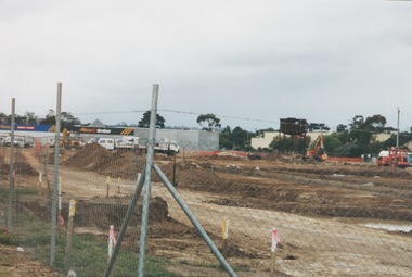
Photograph, 13 April 2000
In 2000 work commenced on the further development of railway land on the west side of Sunbury station for the construction of commercial and entertainment facilities. Prior to this time the land had been undeveloped and was often used to accommodate visiting circus troupes. Cereal storage silos also occupied this area for some time. The development of this area has been a reflection of the rapid expansion of settlement within Sunbury and surrounding areas that occurred during the early years of the twentieth century.A coloured photograph of a fenced off area undergoing development with earthmoving equipment and trucks in operation and some commercial buildings visible in the middle distance.sunbury railway station -
 The Beechworth Burke Museum Research Collection
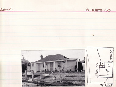
Card (Series) - Index Card, George Tibbits, 6 Kars Street, Beechworth, 1976
George Tibbits, University of Melbourne. Faculty of Architecture, Building and Town & Regional PlanningIndex system that support the research for Beechworth : historical reconstruction / [by] George Tibbits ... [et al]Arranged by street names of BeechworthEach index card includes: street name and number of property, image of property, allotment and section number, property owners and dates of ownership, description of the property according to rate records, property floor plan with dimensions.beechworth, george tibbitsbeechworth, george tibbits -
 City of Moorabbin Historical Society (Operating the Box Cottage Museum)
Document, laminated photocopy of 'Plan of Moorabbin 1850', 1853
Weston Bate, 'A history of Brighton' 1962 informs us that in 1840 Henry Dendy, who was a farmer in Sussex England, paid 5,120 pounds sterling @ 1pound per acre for a 'Special Survey of Land in Port Phillip , Australia. Henry arrived in Australia in 1841 on the frigate 'York' with his wife, son, and three servants. He also took advantage of the Government Assistance of Free Immigrants for Survey Purchasers, to help on his estate and persuaded some Sussex men with their families to follow him. However when Dendy arrived in Port Phillip he found that LaTrobe and Gipps were trying to raise the price of land close to Town to 15pounds per acre. Dendy asked merchant J.B.Were to manage his affairs and they went ahead with plans to subdivide the surveyed land called 'The Brighton Estate' This area of land extended easterly from the Port Phillip Bay to East Boundary Road and from North Road to South Road in the Parish of Bourke Victoria. The Privy Council, England , decide that Henry Dendy could purchase the land at 1pound per acre. Land Sales proceeded from 1844 as more immigrants established market gardens, farms and varied businesses in 'Moorabbin'This is a photocopy of a Map of the Moorabbin , County of Bourke c1850 showing the 'Henry Dendy Special Survey 1841'A photocopy of a Map of the Moorabbin , County of Bourke c1850. A3 size laminatedLeft corner : MOORABBIN / COUNTY OF / BOURKEdendy henry, dendy special survey 1841, brighton, moorabbin, ormond, bentleigh, market gardeners, pioneers early settlers, box william, box elizabeth -
 Glen Eira Historical Society
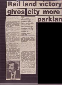
Article - Mayor Jack Campbell 1987-88 (1 of 2)
Newspaper articles and 3 colour photographs relating to Outer Circle Rail Landcouncillor, mayor, jack campbell, brian rudski, malvern, kew, caulfield, premier john cain, mrs cain -
 Bendigo Military Museum
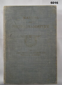
Manual - Manual of Photogrammetry, (Preliminary Edition), 1934 American Society of Photogrammetry, Circa 1934
This book belonged to Brigadier FD Buckland OBE Director of Survey Land HeadquarterHardcover, light blue, 819 pages, text, diagrams, photographsroyal australian survey corps, rasvy, fortuna, army survey regiment, army svy regt, asr, photogrammetry -
 Greensborough Historical Society
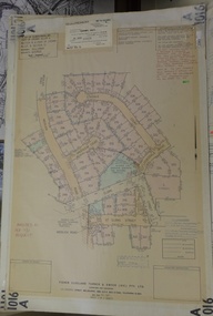
Planning Document, Subdivision Plan # 1016. Corner Weidlich and St Clems Roads Greensborough, 05/10/1981
Plan of Subdivision of land at corner of Weidlich Road and St Clems Road Greensborough.Plan (2 sheets) mounted on heavy card.Stamped and handwritten Council permissions, dates and other details.subdivision plans, weidlich road -
 Greensborough Historical Society
Map, Victoria. Department of Crown Lands and Survey, Keelbundoora; Counties of Bourke and Evelyn, 1950c
Map of the Victorian counties of Bourke and Evelyn showing parish boundaries and land ownership.Show the original landholders for this area.Map on light brown parchment, covered in plastic."L.5305" and "3462" -
 Kiewa Valley Historical Society
Cross Cut Saws x3
Used to cut down trees and to saw the trunks to length. Used to clear the land.Used by the residents of the Kiewa Valley.A. Combination Tasmanian Pattern and Peg Tooth Cross Cut Saw B. Tasmanian Pattern Cross Cut Saw C. Peg Tooth Cross Cut Saw A crosscut saw is a saw designed for cutting wood perpendicular to (across) the wood grain. It cuts when pulled in both directions. The two man crosscut saw has wooden handles that fit into a steel socket at each end. The Tasmanian has a different tooth pattern to the Peg Tooth saw.crosscut saws, two man saws -
 Federation University Historical Collection
Book, Jacobs Lewis Vines Architects and Conservation Planners, Historic Sites Survey: Ballarat Study Area, 1980, 1980
This survey was commissioned by the Land Conservation Council, Australian Heritage Commission and the Ministry for Conservation 114 page report on historic sites in the Ballarat region. It includes information on sites, a schexdule of sites, silte selection and designated areas (ie around towns)historic sites, ballarat, wendy jacobs, miles lewis, gary vines, berringa, buninyong, creswick, dunnstown, fiery creek, lal lal, langi logan, cathcart, mount cole, mount egerton, nerrina, gong gong, wombat state forest, railways, explorers routes, early roads, land conservation council, ausralian hertiage commission, department of planning, icomos (burra) charter, nigel lewis, richard aitken, freehold land, public land, langi ghiran, new jubille mine, birthday tunnel mine, pitfield plains, smythesdale, buninyong company, mount clear, mt clear, canadian gully, warrenheip distillery, thomas mitchell, waterloo, trawalla, beaufort, raglan, internment camps, forestry, mining, mining, mt egerton, mary hollick collection, jubilee mine, burra charter, historica areas data form, explorers, egerton company, black horse mine, mt egerton government battery, kaolin mines, anderson brothers, barkstead, anderson's tramway, clarkesdale, berry leads, birthday tunnel mine berringa, warrenheip, australasian company, mount mercer, lanvi-kal-kal, water race -
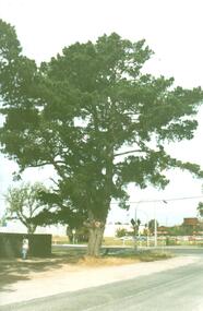
 Victorian Interpretive Projects Inc.
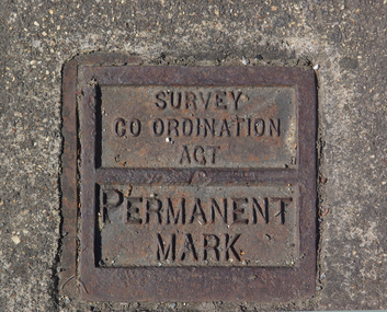
Photograph - Colour, Ballarat Survey Permanent Mark
A survey Permanent Mark was used by surveyors to enable them to plot land accurately.A colour photograph of a metal mark in the footpath on the corner of Ballarat's Sturt Street and Doveton Street. The Permanent Mark was put in place as part of the Survey Co ordination Act ballarat, survey, surveyor, footpath, infrastructure -
 Uniting Church Archives - Synod of Victoria
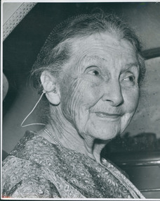
Photograph
Mary Matheson gave land for Uniting AgeWell Strathdon Community Nursing Home.Gloss, black and white image of Mary Matheson.matheson, m, uniting agewell strathdon community nursing home -
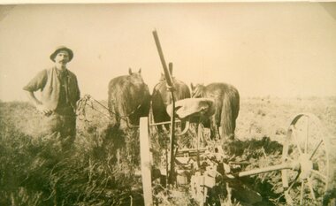 Stawell Historical Society Inc
Photograph, Mr Joseph Mitchell at Deep Lead ploughing in the scrub
Deep Lead Scenes J Mitchell ploughing in the scrub part of clearing the land.stawell deep lead -
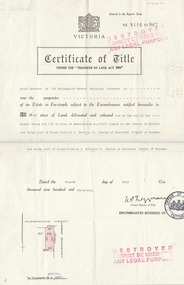 Ukrainian Historical Society Sunshine
Work on paper, Copy of the Certificate of Title for lot 138 Suspension street
copy of Certificate of land on which part of the present Ukrainian Hall stands today. -
 Ballarat Heritage Services
digital copy, Surveyor's Notebook Ballarat East, 24 August 1858
Survey of land in Ballarat East in August 1858 showing hotels and tents etc. Images from Bellair's surveyor's book.eugene bellair, surveying, surveyor, eureka stockade -
 Buninyong & District Historical Society
Photograph - B/W photograph, Mr. Clive J. Brooks, North Eastern slopes of Mount Buninyong from Yendon Road, April 1994
Tree cover on Mount Buninyong and agricultural use of land in 1994 clearly visible.Natural and agricultural record of Mount Buninyong in late 20th centuryBlack and white photograph of the North Eastern slopes of Mount Buninyong from Yendon No. 1 Road. Tree cover and agriculture use clearly visible.mount buninyong, landscape -
 City of Kingston
Pamphlet - Colour, Stillwell and Co, Cheltenham Charman Estate Realising Auction, 1921
Sales plan for land in the suburb of Cheltenham, along Charman Road and Weatherall Street.The developing urban area of Cheltenham within the City of Kingston. This land sale pamphlet illustrates the subdivision of land within the municipality and the changing demographic of the district as new houses are constructed.Colour pamphlet advertising realising auction of the Charman Estate, Cheltenham. Incorporates a map of the estate, showing subdivisions along Charman Road and Weatherall Street.land sales, cheltenham, estate -
 City of Kingston
Pamphlet - Colour, Moorabbin News Print, Auction = Sale Heather Grove Estate, c. 1914
Sales plan for land in the suburb of Cheltenham, bounded by Tulip Grove and Heather Grove.The developing urban area of Highett within the City of Kingston. This land sale pamphlet illustrates the subdivision of land within the municipality and the changing demographic of the district as new houses are constructed close to infrastructure.Colour pamphlet advertising auction of Heather Grove Estate, Cheltenham. Incorporates a map of the estate bordered by Wickham Road, Railway Parade, Highett Road and Point Nepean Road.Handwritten in grey pencil on subdivision 1: Sold / 20/- Handwritten in grey pencil on subdivision 2: 25/- Handwritten in grey pencil on subdivision 3: 30/- Handwritten in grey pencil on subdivision 4: 110 / 30/- Handwritten in grey pencil on subdivisions 1, 11, 10, 9 and 8: Sold Handwritten in grey pencil beneath 'Heather Grove': 20/- 20/- 20/- 20/- Handwritten in black ink on subdivison 12 and 7: £85 Handwritten in back ink on subdivision 5: £60 Handwritten in back ink on subdivision 6: £65 Handwritten in grey pencil above subdivision map: 1-8-9-10-11 Handwritten in grey pencil above subdivision map: [enclosed in a circle] 12- / £75 Handwritten in grey pencil above subdivision map: [enclosed in a circle] 2 / £85 Handwritten in grey pencil above subdivision map: [enclosed in a circle] 3 / £100 Handwritten in grey pencil above subdivision map: [enclosed in a circle] 4 / £100 Handwritten in grey pencil above subdivision map: [enclosed in a circle] 5 / £60 Handwritten in grey pencil above subdivision map: [enclosed in a circle] 6 / £65 Handwritten in grey pencil above subdivision map: [enclosed in a circle] 7 / £25- Handwritten in grey pencil above subdivision map: [enclosed in a circle] £125 / [indecipherable] Handwritten in grey pencil above subdivision map: 37.00 / 18.10 / 56.80 / 3 / [horizontal line] / 59 8 Handwritten in grey pencil along railway line marking: 21/6 / 12/6 / 13/- / 19/-land sales, estate, cheltenham -
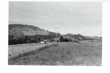
 Buninyong & District Historical Society
Photograph - Black and white photograph, Mount Mercer circa 1920, 1920s
View of landscape and farming land at Mt Mercer in the early part of the twentieth century Representation of the small outlying rural areas near Buninyong in the early twentieth centuryLandscape around Mt Mercer circa 1920mt mercer, landscape -
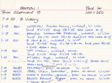 The Beechworth Burke Museum Research Collection
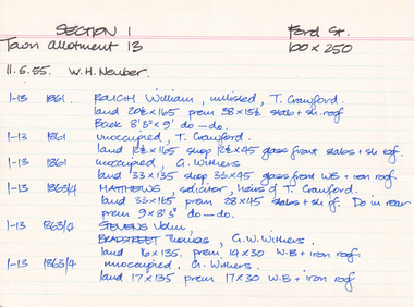
Card (Series) - Index Card, George Tibbits, Ford Street, Beechworth, 1976
George Tibbits, University of Melbourne. Faculty of Architecture, Building and Town & Regional PlanningIndex system that support the research for Beechworth : historical reconstruction / [by] George Tibbits ... [et al]Arranged by street names of BeechworthEach index card includes: street name and number of property, image of property, allotment and section number, property owners and dates of ownership, description of the property according to rate records, property floor plan with dimensions.beechworth, george tibbitsbeechworth, george tibbits -
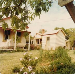 Phillip Island and District Historical Society Inc.
Photograph, 1978/9
The house was built by William Richardson who went to live at Rhyll in 1876. His father, Joseph, owned the land. Joseph had arrived on Phillip Island in 1868 when the first land sale took place. Charlie, William's son, grew up in the house with his parents, brothers and sisters.Coloured photograph showing the kitchen at William Richardson's house in Rhyll.local history, photographs, buildings - historical, housing, coloured photograph, john cook, phillip island, charlie richardson -
 Hume City Civic Collection
Photograph, Early 1990's
The photograph was taken after Coles Supermarket and Sunbury Shopping Square were constructed on the railway land on the east side of the line in 1989, but before the Safeway-Woolworths complex was built in 2000 on the west side of the railway line. The open land on the west side of the line was used by rail communters as a car park.A coloured photograph showing part of the T intersection at Cornish and Horne Streets. A large pine tree is growing at the corner immediately in front of a pedestrian crossing. The railway car park, metal water tower and Coles Supermarket are in the background. A boy is walking along the footpath.cornish street, horne street, water towers, coles supermarket, sunbury railway station, george evans collection -
 The Beechworth Burke Museum Research Collection
Card (Series) - Index Card, George Tibbits, Ford Street, Beechworth, 1976
George Tibbits, University of Melbourne. Faculty of Architecture, Building and Town & Regional PlanningIndex system that support the research for Beechworth : historical reconstruction / [by] George Tibbits ... [et al]Arranged by street names of BeechworthEach index card includes: street name and number of property, image of property, allotment and section number, property owners and dates of ownership, description of the property according to rate records, property floor plan with dimensions.beechworth, george tibbitsbeechworth, george tibbits -
 The Beechworth Burke Museum Research Collection
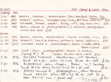
Card (Series) - Index Card, George Tibbits, Camp Street, Beechworth, 1976
George Tibbits, University of Melbourne. Faculty of Architecture, Building and Town & Regional PlanningIndex system that support the research for Beechworth : historical reconstruction / [by] George Tibbits ... [et al]Arranged by street names of BeechworthEach index card includes: street name and number of property, image of property, allotment and section number, property owners and dates of ownership, description of the property according to rate records, property floor plan with dimensions.beechworth, george tibbitsbeechworth, george tibbits -
 City of Moorabbin Historical Society (Operating the Box Cottage Museum)
Newsletter, City of Moorabbin Historical Society June 2009, June 2009
The City of Moorabbin Historical Society was formed c 1960 by a group of Moorabbin residents who were concerned that the history of the area should be preserved. A good response to a call for items related to the historical area of Moorabbin Shire brought donations of a wide variety of artefacts which are now preserved by the current members of CMHS at Box Cottage Museum . Helen Stanley, Secretary of CMHS, began producing a Newsletter for members in April 2007 to provide current information and well researched items of historical interest.Helen Stanley has produced a bi-monthly Newsletter, 2007 - 2013, for the members of the City of Moorabbin Historical Society that contains well researched interesting historical items, notification of upcoming events, current advice from Royal Australian Historical Society , Museums Australia Victoria and activities of Local Historical Societies. The Newsletter is an important record of the activities of the CMHS. Jasper Hale , transported for theft, earned his ‘Ticket of Leave, and purchased land in Dendy’s Special Survey of 1841 later known as East Bentleigh. 2 x A4 paper printed on 3 sides Issue 12 of the bi-monthly, City of Moorabbin Historical Society Newsletter produced by Society member and Secretary, Mrs Helen Stanley in June 2009. Notices of the meeting June 28th , an article in ‘The Leader’ newspaper about the Robert Keys ‘Best Fruit Garden 1881 - 82’ Trophy Cup , a large vinyl banner purchased with Grant money, and while acknowledging the Cottage garden volunteer a request for more helpers at Open Days is made. Jan Rigby, CMHS member, has provided research information about Jasper Hale b 1805 in Gloucester, England, transported to NSW 1830, ‘freed man ‘ 1839, purchased land in Dendy’s Special Survey 1844, sold this land 1846 and died 1884 in Parkes NSW. On arrival as a convict in 1830 his occupation is bricklayer and he can ‘ read and write’. CITY of MOORABBIN HISTORICAL SOCIETY / JUNE 2009 NEWSLETTERcity of moorabbin historical society, stanley helen, rigby jan, melbourne, moorabbin, brighton, cheltenham, ormond, bentleigh, market gardeners, pioneers, early settlers, moorabbin shire, box cottage museum, jasper road ormond, dendy’s special survey 1851, north road brighton, county of bourke, box h., box william, parish of moorabbin, were jonathan, hales jasper, port jackson penal colony, burgess s. william, kemble wiltshire england, stonemason, bricklayer, ‘york’ sailing ship, brummell mary, st. mary’s catholic church sydney, nelson mary ann, ‘george hibbert’ sailing ship, hale james, hale eliza, parkes new south wales gold rush, ballarat gold rush, clunes gold rush, forbes nsw gold rush, parkes historical society -
 Bendigo Historical Society Inc.
Document - LONG GULLY HISTORY GROUP COLLECTION: POSTAL HISTORY OF LONG GULLY
Letter to Mr D Egan from C Duggan for Manager - Public Relations - Australia Post, dated 23 February 1983. Letter mentions the history of the Long Gully Post Office. There are many gaps in the history. Mentioned are the number of letters, newspapers, Money Orders, telegrams, mail articles, postal notes and expenditure. Values of money orders, telegrams and postal notes are mentioned. Postmasters/mistresses were P Pentreath, A Pentreath, Amelia Daniel, Mrs S A Wilcock, Mark H Webb, William J H Read, Mrs Elsie Anderson, Sydney Gordon Dawson, John Henry Bennett, Miss Margaret Mulvey, John Henry Bennett, Henry William Purchase, Mr R F Warren, Mrs Margaret Cecily Kennedy, Edward Charles Landers, Mrs Margaret Landers, Shirley Egan, Brian Matthew Egan and Shirley and Max Volk.bendigo, history, long gully history group, the long gully history group - postal history of long gully, australia post, mr d egan, p pentreath, a pentreath, amelia daniel, mrs s a wilcock, mark h webb, william j h read, mrs elsie anderson, sydney gordon dawson, john henry bennett, miss margaret mulvey, henry william purchase, mr r f warren, mrs margaret cecily kennedy, edward charles landers, mrs margaret landers, shirley egan, brian matthew egan, shirley and max volk, c duggan