Showing 3678 items
matching on the beach
-
 Flagstaff Hill Maritime Museum and Village
Photograph
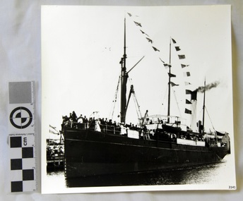
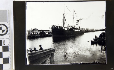
Black and White Photograph of S.S Casino arriving in Port. Taken 1930-1932. People on the deck and on the river banks waving. Smoke coming from funnel. The S.S. Casino was a passenger and freight steamer built in Dundee, Scotland, in 1882 for the Newcastle and Hunter River Steam Navigation Company of N.S.W. She weighed 425 tons gross with a length of 160.4 feet, beam of 24.1 feet and depth of 10.2 feet. She had saloon accommodation for 35 people, forecabin for 25 more people, and she carried 300 tons of cargo. While on her delivery journey on May 30th 1882 the S.S. Casino called in at the Port of Warrnambool for coal ., narrowly escaping going ashore in gale force winds due to the quick action of the pilot. At that time, still at anchor, she impressed the directors of the Belfast and Koroit Steam Navigation Company so much that they bought her immediately; she was ideal for trade in along the West Coast of Victoria. (Belfast is the original name for Port Fairy, South West Victoria. The Belfast and Koroit Steam Navigation Company was first managed by Messers. Saltau and Osburne and after the passing of Mr. Osburne, by produce merchants Messers H. Sautau and Sons, whose had a hay and corn store and shipping agency was on the corner of Liebig and Koroit Streets in Warrnambool. ) The S.S. Casino became “the most famous steamer to operate in Victorian waters along the West Coast” by author Jack Loney. Captain Boyd was her first Master, followed by Captain Chapman, who stayed with her 1890 until 1924. Captain W. Robertson followed for a short term, then Captain Middleton then took command 1925 - 1932. The S.S. Casino had several mishaps during her life. One was on 3rd January 1898 when she collided with the S.S. Flinders in Apollo Bay with minor damage. Another was on 24th October 1924 when she grounded on a reef at Point Hawdon near Grey River and most of her cargo (of Christmas goods) had to be dumped into the sea. Then in February 1929 she was ‘holed’ when she struck a submerged object as she entered Lady Bay, Warrnambool. On the morning of 10th July 1932, after attempting to berth at Apollo Bay jetty in heavy seas, Captain Middleton decided to take her out into the bay and wait until the seas abated. It was not realised that the anchor used to steady her as she manoeuvred to her berth had pierced her hull. She put about and headed for the beach but sank. Captain Middleton and nine others lost their lives; nine people were rescued including the two female passengers . Captain Middleton had been in charge of the S.S. Casino for seven years. He was the first ship’s Master to lose his life through shipwreck in the West Coast trade. In the years following the turn of the century the S.S. Casino remained the only regular trader with normal passenger accommodation along the West Coast. From 1882 she had made at least 2,500 voyages on the one run. Flagstaff Hill’s collection has a photograph of a portrait of Captain Chapman, , a ship model of the S.S. Casino that shows both forms of power under which she sailed, steam and sail. The ship is painted green and flies three flags. The inscription across the case of the ship model, incorrectly dated, tells the sad story of the wreck of the ship and the loss of lives on July 10th 1932 at Apollo Bay. A print in the Collection show S.S. Casino underway in heavy sea off Point Lonsdale, another two photographs show her at the Port of Warrnambool, leaving from the Breakwater in Lady Bay and another identifies the S.S. Casino as a ship from the Belfast and Koroit Steam Navigation Company. (Belfast is the original name for the township of Port Fairy). This photograph is significant because of its association with the coastal trader S.S. Casino 1930 -1932 and its significance to trade along Victoria's West Coast in the late 19th and early 20th century. The wreck of the S.S. Casino is considered an important part of Victorian and Australian cultural heritage and as such has been declared and protected as an Historic Shipwreck Black and White Photograph of S.S Casino arriving in Port. Taken 1930-1932. People on the deck and on the river banks waving. Smoke coming from funnel.flagstaff hill, warrnambool, shipwrecked coast, flagstaff hill maritime museum, maritime museum, shipwreck coast, flagstaff hill maritime village, great ocean road, newcastle and hunter river steam navigation company, belfast and koroit steam navigation company, h. sautau and sons, s.s. casino, west coast trader s.s. casino, victorian coastal trader, captain boyd, captain w. robertson, captain chapman, captain middleton, apollo bay shipwreck, s.s. casino at lady bay warrnambool, saltau and osburne -
 Flagstaff Hill Maritime Museum and Village
Photograph
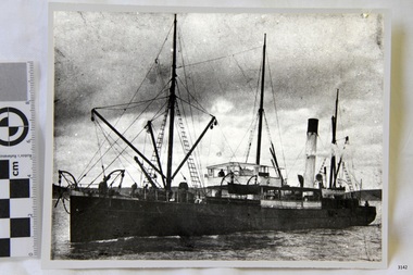
Black and White Photograph of S.S Casino taken 1930-1932. Ship has men on deck and a man at the helm. Hills and the shore can be seen in the background. The S.S. Casino was a passenger and freight steamer built in Dundee, Scotland, in 1882 for the Newcastle and Hunter River Steam Navigation Company of N.S.W. She weighed 425 tons gross with a length of 160.4 feet, beam of 24.1 feet and depth of 10.2 feet. She had saloon accommodation for 35 people, forecabin for 25 more people, and she carried 300 tons of cargo. While on her delivery journey on May 30th 1882 the S.S. Casino called in at the Port of Warrnambool for coal ., narrowly escaping going ashore in gale force winds due to the quick action of the pilot. At that time, still at anchor, she impressed the directors of the Belfast and Koroit Steam Navigation Company so much that they bought her immediately; she was ideal for trade in along the West Coast of Victoria. (Belfast is the original name for Port Fairy, South West Victoria. The Belfast and Koroit Steam Navigation Company was first managed by Messers. Saltau and Osburne and after the passing of Mr. Osburne, by produce merchants Messers H. Sautau and Sons, whose had a hay and corn store and shipping agency was on the corner of Liebig and Koroit Streets in Warrnambool. ) The S.S. Casino became “the most famous steamer to operate in Victorian waters along the West Coast” by author Jack Loney. Captain Boyd was her first Master, followed by Captain Chapman, who stayed with her 1890 until 1924. Captain W. Robertson followed for a short term, then Captain Middleton then took command 1925 - 1932. The S.S. Casino had several mishaps during her life. One was on 3rd January 1898 when she collided with the S.S. Flinders in Apollo Bay with minor damage. Another was on 24th October 1924 when she grounded on a reef at Point Hawdon near Grey River and most of her cargo (of Christmas goods) had to be dumped into the sea. Then in February 1929 she was ‘holed’ when she struck a submerged object as she entered Lady Bay, Warrnambool. On the morning of 10th July 1932, after attempting to berth at Apollo Bay jetty in heavy seas, Captain Middleton decided to take her out into the bay and wait until the seas abated. It was not realised that the anchor used to steady her as she manoeuvred to her berth had pierced her hull. She put about and headed for the beach but sank. Captain Middleton and nine others lost their lives; nine people were rescued including the two female passengers . Captain Middleton had been in charge of the S.S. Casino for seven years. He was the first ship’s Master to lose his life through shipwreck in the West Coast trade. In the years following the turn of the century the S.S. Casino remained the only regular trader with normal passenger accommodation along the West Coast. From 1882 she had made at least 2,500 voyages on the one run. Flagstaff Hill’s collection has a photograph of a portrait of Captain Chapman, , a ship model of the S.S. Casino that shows both forms of power under which she sailed, steam and sail. The ship is painted green and flies three flags. The inscription across the case of the ship model, incorrectly dated, tells the sad story of the wreck of the ship and the loss of lives on July 10th 1932 at Apollo Bay. A print in the Collection show S.S. Casino underway in heavy sea off Point Lonsdale, another two photographs show her at the Port of Warrnambool, leaving from the Breakwater in Lady Bay and another identifies the S.S. Casino as a ship from the Belfast and Koroit Steam Navigation Company. (Belfast is the original name for the township of Port Fairy). This ohotograph is significant because of its association with the coastal trader S.S. Casino 1882-1932 and its significance to trade along Victoria's West Coast in the late 19th and early 20th century. The wreck of the S.S. Casino is considered an important part of Victorian and Australian cultural heritage and as such has been declared and protected as an Historic Shipwreck under State and Commonwealth Law in the Commonwealth Historic Shipwrecks Act (1976). Black and White Photograph of S.S Casino taken 1932-1932. Ship has men on deck and a man at the helm. Hills and the shore can be seen in the background.flagstaff hill, warrnambool, shipwrecked coast, flagstaff hill maritime museum, maritime museum, shipwreck coast, flagstaff hill maritime village, great ocean road, newcastle and hunter river steam navigation company, belfast and koroit steam navigation company, h. sautau and sons, s.s. casino, west coast trader s.s. casino, victorian coastal trader, captain boyd, captain w. robertson, captain chapman, captain middleton, apollo bay shipwreck, s.s. casino at lady bay warrnambool, saltau and osburne -
 Flagstaff Hill Maritime Museum and Village
Photograph
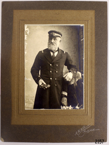
The S.S. Casino was a passenger and freight steamer built in Dundee, Scotland, in 1882 for the Newcastle and Hunter River Steam Navigation Company of N.S.W. She weighed 425 tons gross with a length of 160.4 feet, beam of 24.1 feet and depth of 10.2 feet. She had saloon accommodation for 35 people, forecabin for 25 more people, and she carried 300 tons of cargo. While on her delivery journey on May 30th 1882 the S.S. Casino called in at the Port of Warrnambool for coal ., narrowly escaping going ashore in gale force winds due to the quick action of the pilot. At that time, still at anchor, she impressed the directors of the Belfast and Koroit Steam Navigation Company so much that they bought her immediately; she was ideal for trade in along the West Coast of Victoria. (The Belfast and Koroit Steam Navigation Company was first managed by Messers. Saltau and Osburne and after the passing of Mr. Osburne, by produce merchants Messers H. Sautau and Sons, whose had a hay and corn store and shipping agency was on the corner of Liebig and Koroit Streets in Warrnambool. ) The S.S. Casino became “the most famous steamer to operate in Victorian waters along the West Coast” by author Jack Loney. Captain Boyd was her first Master, followed by Captain Chapman, who stayed with her 1890 until 1924. Captain W. Robertson followed for a short term, then Captain Middleton then took command 1925 - 1932. The S.S. Casino had several mishaps during her life. One was on 3rd January 1898 when she collided with the S.S. Flinders in Apollo Bay with minor damage. Another was on 24th October 1924 when she grounded on a reef at Point Hawdon near Grey River and most of her cargo (of Christmas goods) had to be dumped into the sea. Then in February 1929 she was ‘holed’ when she struck a submerged object as she entered Lady Bay, Warrnambool. On the morning of 10th July 1932, after attempting to berth at Apollo Bay jetty in heavy seas, Captain Middleton decided to take her out into the bay and wait until the seas abated. It was not realised that the anchor used to steady her as she manoeuvred to her berth had pierced her hull. She put about and headed for the beach but sank. Captain Middleton and nine others lost their lives; nine people were rescued including the two female passengers . Captain Middleton had been in charge of the S.S. Casino for seven years. He was the first ship’s Master to lose his life through shipwreck in the West Coast trade. In the years following the turn of the century the S.S. Casino remained the only regular trader with normal passenger accommodation along the West Coast. From 1882 she had made at least 2,500 voyages on the one run. Flagstaff Hill’s collection has a photograph of a portrait of Captain Chapman, , a ship model of the S.S. Casino that shows both forms of power under which she sailed, steam and sail. The ship is painted green and flies three flags. The inscription across the case of the ship model, incorrectly dated, tells the sad story of the wreck of the ship and the loss of lives on July 10th 1932 at Apollo Bay. A print in the Collection show S.S. Casino underway in the heavy sea off Point Lonsdale, another two photographs show her at the Port of Warrnambool, leaving from the Breakwater in Lady Bay and another identifies the S.S. Casino as a ship from the Belfast and Koroit Steam Navigation Company. (Belfast is the original name for the township of Port Fairy).This photograph of Captain Capman is significant because of its association with the coastal trader S.S. Casino and its significance to trade along Victoria's West Coast in the late 19th and early 20th century. The wreck of the S.S. Casino is considered an important part of Victorian and Australian cultural heritage and as such has been declared and protected as an Historic Shipwreck under State and Commonwealth Law in the Commonwealth Historic Shipwrecks Act (1976). Photograph of Captain Chapman of the "S.S.Casino", mounted on card board. flagstaff hill, warrnambool, shipwrecked coast, flagstaff hill maritime museum, maritime museum, shipwreck coast, flagstaff hill maritime village, great ocean road, newcastle and hunter river steam navigation company, belfast and koroit steam navigation company, h. sautau and sons, s.s. casino, west coast trader s.s. casino, victorian coastal trader, captain boyd, captain w. robertson, captain chapman, captain middleton, apollo bay shipwreck, s.s. casino at lady bay warrnambool, saltau and osburne -
 Federation University Historical Collection
Photograph, R. Millist, Hanlon Consols Mine Rokewood, 1901
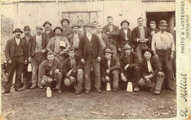
The photo depicts one shift of mine hands at Hanlon Consols Mine Rokewod in 1901. ist on the left is George Edgar Yung. George was born in Ararat the son of Yohann Godlip and Christina (b Weller)Yung. They lived at Happy Valley near Linton. and Piggoreet. Yohann was a miner and died in the All Nations Mine collapse at Derwnt Jack's in 1877. Interesting to note in the following information that the Hanlon Consol mamager, William Maughan was also the manager of the Try Again Mine in Piggoreet. He was also on the six man school committee of Piggoreet Common School No. 726. (Is this why George Yung ended up working in Rokewood because of a previous connection at Piggoreet? George married Clara Emma Smith from Happy Valley and worked in a mine at Allendale. They later moved to Yendon) About the Hanlon gold mining company near Rokewood. 1901 - Information Bendigo Prospecting Club, 21/08/2020. Information provided once again by Peter McCarthy. Christopher Hanlon had put down a line of bores south of the Rokewood main street, looking for a continuation of the Break O’Day lead which had been worked for two or three miles with highly payable results, though in a primitive manner. Ground was being paddocked 30 feet deep and made to pay. The bores suggested the sinking would be about 70 feet and a shaft site was selected at the back of Stanbrook’s Hotel. The Hanlon Gold Mining Company was formed in March 1895 and the shaft was bottomed at 68 feet, getting just over an ounce of gold from the shaft bottom. By January 1896, the poppet heads were up, and steam plant was nearly ready. The mine produced 846 oz by September, which was not as good as expected, but they installed a second puddling machine. The mine was profitable for the next three years, with periods of prospecting and the need to install steam pumps in 1897. A second shaft was sunk in 1899, which bottomed at 86 feet on good wash and was sunk on to 109 feet. 1743 oz of gold had been produced in six months to September 1899, but the No1 shaft was let on tribute as the No2 workings were opened and machinery installed the following year. The No1 shaft tributors broke even in 1900 and in 1901 the shaft was shut down, with the No1 shaft machinery sold late in 1902. By September 1901, the mine had produced gold worth £66,124 and the No2 shaft main drive was in 346 feet, with gold being found mainly in crevices in the hard floor. Mining continued, but once the No2 shaft workings met up with the old No1 shaft workings at the end of 1902 there was not much wash remaining. The mine was let on tribute in June 1903 and a drive was put in to test deeper ground. The company was wound up in February 1904 and the plant sold. From what they discovered, the manager concluded that the mine sat at the edge of an ancient coastline and the gold was in a beach deposit. The total gold production from the mine was worth £73,294. J Lee Archer JP, shareholder, was the manager of the Bank of Victoria in Ballarat. Born in Tasmania, he came to Victoria with his parents and first came to Ballarat in 1855 as a junior clerk with the bank. He died in 1902 aged 64. Alexander J. Peacock was a legal manager and a share broker. In 1897 Peacock, born in Creswick, had been elected as one of the Victorian delegates to the Constitutional Convention which wrote the Australian Constitution. He later became a politician, state treasurer and three times state premier of Victoria and was knighted KCGM. He died in 1933 aged 72. William Maughan, director, was an English miner who came to Victoria in the 1850s and became a mine manager, managing the Try Again at Piggoreet, Ryan’s Freehold and the Madam Berry, among others. He died in Williamstown in 1915 aged 85. Sepia photographRhs front of photo: R. Millist Phto & Lanternist Geelong Verso (upside down): ONE SHIFT OF MINE HANDS HANLON CONSOLS MINE ROKEWOOD 1901 Grandfather Yung 1st on left rokewood, hanlon consols mine, shift of mine workers 1901, gold mines, george edgar godlip yung, william maughan -
 Eltham District Historical Society Inc
Photograph, Looking north across the Fitzsimons Lane Bridge over Yarra River between Eltham and Templestowe, c.1985, 1985c
Turnoff to Candlebark Park on right. The bridge over the Yarra River was initially opened September 22nd, 1961. Newspaper reports at the time of opening stated it linked Bolton Street, Eltham, with Fitzsimons Lane, Templestowe. In 1955 the Country Roads Board (CRB) produced survey plans that showed proposed land acquisition for the future bridge and road approaches. The 1955 plan shows that it was proposed to connect Fitzsimons Lane with Bolton Street in Eltham by a diagonal road across the river. The road connection would then continue along Bolton Street to Main Road. Prior to construction of the bridge the CRB modified the proposal significantly so that there was a new road parallel with Bolton Street and then curving to join Main Road at what was then its intersection with Old Eltham Road. This involved significantly more land acquisition and altered the pattern of land subdivision through this corridor. Initially the new road was just a single two-way carriageway as it would have required a significant widening of the cutting on the Shire of Eltham side of the river. The road was officially un-named but was known locally as the Eltham-Templestowe Road. The 1966 Melway street directory and other 1960s editions also listed the road as the Eltham-Templestowe Road. In December 1970, Eltham Shire Council, in pursuance of the provisions of the Local Government Act, named it Templestowe Road. The road was renamed Fitzsimons Lane around 1984 in conformity with the section south of the river. In 1991 a new bridge was built to the west of the original bridge. Fitzsimons Lane was widened to four traffic lanes although on the Eltham side this was done within the limits of the existing cutting. NEW BRIDGE STARTS THEM EXPLORING Without any fanfares, Country Roads Board workmen on Friday afternoon put the finishing touches to the approaches, removed the barricades, and let the traffic roll over the new Yarra bridge linking Bolton Street, Eltham, with Fitzsimons Lane, Templestowe. Over the week-end many “bridge watchers” who were making one of their periodic inspections of the progress on the new bridge found to their surprise that they could drive over it, so that people who had gone for a run out to Eltham suddenly found themselves wandering through Templestowe and Doncaster. By Monday the word of the bridge’s opening had got around sufficiently for many regular travellers to the city from Eltham and beyond to vary the monotony by going to town via Templestowe and Kew instead of through Heidelberg. They were surprised at the distances – about 3 ½ miles from Eltham to Templestowe, 6 miles from Eltham Shire hall to the Lower Heidelberg Road-Banksia Street intersection. NEW NEIGHBOURS For people on both sides of the river, the new bridge has turned distant friends into near neighbours. A Greensborough man on Sunday took 35 minutes to reach the home of a friend in East Doncaster, but the return trip over the new bridge took only 17 minutes. It will be some time yet before most people work out the possibilities in shorter and quicker trips form the north-eastern areas to the eastern and south-eastern suburbs. The coming of the warmer months will soon teach many, though the short cuts to Peninsular beaches and eastern suburban drive-ins. And before very long it is likely there will be a Tramways bus running from Templestowe to Eltham station. NEW BRIDGE STARTS THEM EXPLORING (1961, September 27). The Diamond Valley News (News clipping held in SEA_74-1_047) The previously un-named road between Main Road and Yarra River, Eltham South, east of Bolton Street was named Templestowe Road, December 15, 1970 NAMING OF STREETS AND ROADS. (1970, December 15). The Diamond Valley News (News clipping held in SEA_74-2_022)Colour photographinfrastructure, shire of eltham infrastructure, bridge, fitzsimons lane bridge, yarra river, candlebark park, red nose day -
 Eltham District Historical Society Inc
Photograph, Fitzsimons Lane Bridge over Yarra River between Eltham and Templestowe
The bridge over the Yarra River was initially opened September 22nd, 1961. Newspaper reports at the time of opening stated it linked Bolton Street, Eltham, with Fitzsimons Lane, Templestowe. In 1955 the Country Roads Board (CRB) produced survey plans that showed proposed land acquisition for the future bridge and road approaches. The 1955 plan shows that it was proposed to connect Fitzsimons Lane with Bolton Street in Eltham by a diagonal road across the river. The road connection would then continue along Bolton Street to Main Road. Prior to construction of the bridge the CRB modified the proposal significantly so that there was a new road parallel with Bolton Street and then curving to join Main Road at what was then its intersection with Old Eltham Road. This involved significantly more land acquisition and altered the pattern of land subdivision through this corridor. Initially the new road was just a single two-way carriageway as it would have required a significant widening of the cutting on the Shire of Eltham side of the river. The road was officially un-named but was known locally as the Eltham-Templestowe Road. The 1966 Melway street directory and other 1960s editions also listed the road as the Eltham-Templestowe Road. In December 1970, Eltham Shire Council, in pursuance of the provisions of the Local Government Act, named it Templestowe Road. The road was renamed Fitzsimons Lane around 1984 in conformity with the section south of the river. In 1991 a new bridge was built to the west of the original bridge. Fitzsimons Lane was widened to four traffic lanes although on the Eltham side this was done within the limits of the existing cutting. NEW BRIDGE STARTS THEM EXPLORING Without any fanfares, Country Roads Board workmen on Friday afternoon put the finishing touches to the approaches, removed the barricades, and let the traffic roll over the new Yarra bridge linking Bolton Street, Eltham, with Fitzsimons Lane, Templestowe. Over the week-end many “bridge watchers” who were making one of their periodic inspections of the progress on the new bridge found to their surprise that they could drive over it, so that people who had gone for a run out to Eltham suddenly found themselves wandering through Templestowe and Doncaster. By Monday the word of the bridge’s opening had got around sufficiently for many regular travellers to the city from Eltham and beyond to vary the monotony by going to town via Templestowe and Kew instead of through Heidelberg. They were surprised at the distances – about 3 ½ miles from Eltham to Templestowe, 6 miles from Eltham Shire hall to the Lower Heidelberg Road-Banksia Street intersection. NEW NEIGHBOURS For people on both sides of the river, the new bridge has turned distant friends into near neighbours. A Greensborough man on Sunday took 35 minutes to reach the home of a friend in East Doncaster, but the return trip over the new bridge took only 17 minutes. It will be some time yet before most people work out the possibilities in shorter and quicker trips form the north-eastern areas to the eastern and south-eastern suburbs. The coming of the warmer months will soon teach many, though the short cuts to Peninsular beaches and eastern suburban drive-ins. And before very long it is likely there will be a Tramways bus running from Templestowe to Eltham station. NEW BRIDGE STARTS THEM EXPLORING (1961, September 27). The Diamond Valley News (News clipping held in SEA_74-1_047) The previously un-named road between Main Road and Yarra River, Eltham South, east of Bolton Street was named Templestowe Road, December 15, 1970 NAMING OF STREETS AND ROADS. (1970, December 15). The Diamond Valley News (News clipping held in SEA_74-2_022)Black and white photographinfrastructure, shire of eltham infrastructure, bridge, fitzsimons lane bridge, yarra river -
 Eltham District Historical Society Inc
Photograph, Looking south across the Fitzsimons Lane Bridge over Yarra River between Eltham and Templestowe
The bridge over the Yarra River was initially opened September 22nd, 1961. Newspaper reports at the time of opening stated it linked Bolton Street, Eltham, with Fitzsimons Lane, Templestowe. In 1955 the Country Roads Board (CRB) produced survey plans that showed proposed land acquisition for the future bridge and road approaches. The 1955 plan shows that it was proposed to connect Fitzsimons Lane with Bolton Street in Eltham by a diagonal road across the river. The road connection would then continue along Bolton Street to Main Road. Prior to construction of the bridge the CRB modified the proposal significantly so that there was a new road parallel with Bolton Street and then curving to join Main Road at what was then its intersection with Old Eltham Road. This involved significantly more land acquisition and altered the pattern of land subdivision through this corridor. Initially the new road was just a single two-way carriageway as it would have required a significant widening of the cutting on the Shire of Eltham side of the river. The road was officially un-named but was known locally as the Eltham-Templestowe Road. The 1966 Melway street directory and other 1960s editions also listed the road as the Eltham-Templestowe Road. In December 1970, Eltham Shire Council, in pursuance of the provisions of the Local Government Act, named it Templestowe Road. The road was renamed Fitzsimons Lane around 1984 in conformity with the section south of the river. In 1991 a new bridge was built to the west of the original bridge. Fitzsimons Lane was widened to four traffic lanes although on the Eltham side this was done within the limits of the existing cutting. NEW BRIDGE STARTS THEM EXPLORING Without any fanfares, Country Roads Board workmen on Friday afternoon put the finishing touches to the approaches, removed the barricades, and let the traffic roll over the new Yarra bridge linking Bolton Street, Eltham, with Fitzsimons Lane, Templestowe. Over the week-end many “bridge watchers” who were making one of their periodic inspections of the progress on the new bridge found to their surprise that they could drive over it, so that people who had gone for a run out to Eltham suddenly found themselves wandering through Templestowe and Doncaster. By Monday the word of the bridge’s opening had got around sufficiently for many regular travellers to the city from Eltham and beyond to vary the monotony by going to town via Templestowe and Kew instead of through Heidelberg. They were surprised at the distances – about 3 ½ miles from Eltham to Templestowe, 6 miles from Eltham Shire hall to the Lower Heidelberg Road-Banksia Street intersection. NEW NEIGHBOURS For people on both sides of the river, the new bridge has turned distant friends into near neighbours. A Greensborough man on Sunday took 35 minutes to reach the home of a friend in East Doncaster, but the return trip over the new bridge took only 17 minutes. It will be some time yet before most people work out the possibilities in shorter and quicker trips form the north-eastern areas to the eastern and south-eastern suburbs. The coming of the warmer months will soon teach many, though the short cuts to Peninsular beaches and eastern suburban drive-ins. And before very long it is likely there will be a Tramways bus running from Templestowe to Eltham station. NEW BRIDGE STARTS THEM EXPLORING (1961, September 27). The Diamond Valley News (News clipping held in SEA_74-1_047) The previously un-named road between Main Road and Yarra River, Eltham South, east of Bolton Street was named Templestowe Road, December 15, 1970 NAMING OF STREETS AND ROADS. (1970, December 15). The Diamond Valley News (News clipping held in SEA_74-2_022)Black and white photographinfrastructure, shire of eltham infrastructure, bridge, fitzsimons lane bridge, yarra river -
 Eltham District Historical Society Inc
Photograph, Fitzsimons Lane Bridge over Yarra River between Eltham and Templestowe
The bridge over the Yarra River was initially opened September 22nd, 1961. Newspaper reports at the time of opening stated it linked Bolton Street, Eltham, with Fitzsimons Lane, Templestowe. In 1955 the Country Roads Board (CRB) produced survey plans that showed proposed land acquisition for the future bridge and road approaches. The 1955 plan shows that it was proposed to connect Fitzsimons Lane with Bolton Street in Eltham by a diagonal road across the river. The road connection would then continue along Bolton Street to Main Road. Prior to construction of the bridge the CRB modified the proposal significantly so that there was a new road parallel with Bolton Street and then curving to join Main Road at what was then its intersection with Old Eltham Road. This involved significantly more land acquisition and altered the pattern of land subdivision through this corridor. Initially the new road was just a single two-way carriageway as it would have required a significant widening of the cutting on the Shire of Eltham side of the river. The road was officially un-named but was known locally as the Eltham-Templestowe Road. The 1966 Melway street directory and other 1960s editions also listed the road as the Eltham-Templestowe Road. In December 1970, Eltham Shire Council, in pursuance of the provisions of the Local Government Act, named it Templestowe Road. The road was renamed Fitzsimons Lane around 1984 in conformity with the section south of the river. In 1991 a new bridge was built to the west of the original bridge. Fitzsimons Lane was widened to four traffic lanes although on the Eltham side this was done within the limits of the existing cutting. NEW BRIDGE STARTS THEM EXPLORING Without any fanfares, Country Roads Board workmen on Friday afternoon put the finishing touches to the approaches, removed the barricades, and let the traffic roll over the new Yarra bridge linking Bolton Street, Eltham, with Fitzsimons Lane, Templestowe. Over the week-end many “bridge watchers” who were making one of their periodic inspections of the progress on the new bridge found to their surprise that they could drive over it, so that people who had gone for a run out to Eltham suddenly found themselves wandering through Templestowe and Doncaster. By Monday the word of the bridge’s opening had got around sufficiently for many regular travellers to the city from Eltham and beyond to vary the monotony by going to town via Templestowe and Kew instead of through Heidelberg. They were surprised at the distances – about 3 ½ miles from Eltham to Templestowe, 6 miles from Eltham Shire hall to the Lower Heidelberg Road-Banksia Street intersection. NEW NEIGHBOURS For people on both sides of the river, the new bridge has turned distant friends into near neighbours. A Greensborough man on Sunday took 35 minutes to reach the home of a friend in East Doncaster, but the return trip over the new bridge took only 17 minutes. It will be some time yet before most people work out the possibilities in shorter and quicker trips form the north-eastern areas to the eastern and south-eastern suburbs. The coming of the warmer months will soon teach many, though the short cuts to Peninsular beaches and eastern suburban drive-ins. And before very long it is likely there will be a Tramways bus running from Templestowe to Eltham station. NEW BRIDGE STARTS THEM EXPLORING (1961, September 27). The Diamond Valley News (News clipping held in SEA_74-1_047) The previously un-named road between Main Road and Yarra River, Eltham South, east of Bolton Street was named Templestowe Road, December 15, 1970 NAMING OF STREETS AND ROADS. (1970, December 15). The Diamond Valley News (News clipping held in SEA_74-2_022)Black and white photographinfrastructure, shire of eltham infrastructure, bridge, fitzsimons lane bridge, yarra river -
 Eltham District Historical Society Inc
Photograph, Russell Yeoman, Fitzsimons Lane Bridge over Yarra River between Eltham and Templestowe, c.1970, 1970c
The bridge over the Yarra River was initially opened September 22nd, 1961. Newspaper reports at the time of opening stated it linked Bolton Street, Eltham, with Fitzsimons Lane, Templestowe. In 1955 the Country Roads Board (CRB) produced survey plans that showed proposed land acquisition for the future bridge and road approaches. The 1955 plan shows that it was proposed to connect Fitzsimons Lane with Bolton Street in Eltham by a diagonal road across the river. The road connection would then continue along Bolton Street to Main Road. Prior to construction of the bridge the CRB modified the proposal significantly so that there was a new road parallel with Bolton Street and then curving to join Main Road at what was then its intersection with Old Eltham Road. This involved significantly more land acquisition and altered the pattern of land subdivision through this corridor. Initially the new road was just a single two-way carriageway as it would have required a significant widening of the cutting on the Shire of Eltham side of the river. The road was officially un-named but was known locally as the Eltham-Templestowe Road. The 1966 Melway street directory and other 1960s editions also listed the road as the Eltham-Templestowe Road. In December 1970, Eltham Shire Council, in pursuance of the provisions of the Local Government Act, named it Templestowe Road. The road was renamed Fitzsimons Lane around 1984 in conformity with the section south of the river. In 1991 a new bridge was built to the west of the original bridge. Fitzsimons Lane was widened to four traffic lanes although on the Eltham side this was done within the limits of the existing cutting. NEW BRIDGE STARTS THEM EXPLORING Without any fanfares, Country Roads Board workmen on Friday afternoon put the finishing touches to the approaches, removed the barricades, and let the traffic roll over the new Yarra bridge linking Bolton Street, Eltham, with Fitzsimons Lane, Templestowe. Over the week-end many “bridge watchers” who were making one of their periodic inspections of the progress on the new bridge found to their surprise that they could drive over it, so that people who had gone for a run out to Eltham suddenly found themselves wandering through Templestowe and Doncaster. By Monday the word of the bridge’s opening had got around sufficiently for many regular travellers to the city from Eltham and beyond to vary the monotony by going to town via Templestowe and Kew instead of through Heidelberg. They were surprised at the distances – about 3 ½ miles from Eltham to Templestowe, 6 miles from Eltham Shire hall to the Lower Heidelberg Road-Banksia Street intersection. NEW NEIGHBOURS For people on both sides of the river, the new bridge has turned distant friends into near neighbours. A Greensborough man on Sunday took 35 minutes to reach the home of a friend in East Doncaster, but the return trip over the new bridge took only 17 minutes. It will be some time yet before most people work out the possibilities in shorter and quicker trips form the north-eastern areas to the eastern and south-eastern suburbs. The coming of the warmer months will soon teach many, though the short cuts to Peninsular beaches and eastern suburban drive-ins. And before very long it is likely there will be a Tramways bus running from Templestowe to Eltham station. NEW BRIDGE STARTS THEM EXPLORING (1961, September 27). The Diamond Valley News (News clipping held in SEA_74-1_047) The previously un-named road between Main Road and Yarra River, Eltham South, east of Bolton Street was named Templestowe Road, December 15, 1970 NAMING OF STREETS AND ROADS. (1970, December 15). The Diamond Valley News (News clipping held in SEA_74-2_022)Roll of 35mm black and white negative film, 4 of 7 stripsIlford HP4bridge, bridges, fitzsimons lane bridge, infrastructure, shire of eltham infrastructure, yarra river -
 Eltham District Historical Society Inc
Photograph, Fitzsimons Lane Bridge over Yarra River between Eltham and Templestowe, c.1966, 1966c
The bridge over the Yarra River was initially opened September 22nd, 1961. Newspaper reports at the time of opening stated it linked Bolton Street, Eltham, with Fitzsimons Lane, Templestowe. In 1955 the Country Roads Board (CRB) produced survey plans that showed proposed land acquisition for the future bridge and road approaches. The 1955 plan shows that it was proposed to connect Fitzsimons Lane with Bolton Street in Eltham by a diagonal road across the river. The road connection would then continue along Bolton Street to Main Road. Prior to construction of the bridge the CRB modified the proposal significantly so that there was a new road parallel with Bolton Street and then curving to join Main Road at what was then its intersection with Old Eltham Road. This involved significantly more land acquisition and altered the pattern of land subdivision through this corridor. Initially the new road was just a single two-way carriageway as it would have required a significant widening of the cutting on the Shire of Eltham side of the river. The road was officially un-named but was known locally as the Eltham-Templestowe Road. The 1966 Melway street directory and other 1960s editions also listed the road as the Eltham-Templestowe Road. In December 1970, Eltham Shire Council, in pursuance of the provisions of the Local Government Act, named it Templestowe Road. The road was renamed Fitzsimons Lane around 1984 in conformity with the section south of the river. In 1991 a new bridge was built to the west of the original bridge. Fitzsimons Lane was widened to four traffic lanes although on the Eltham side this was done within the limits of the existing cutting. NEW BRIDGE STARTS THEM EXPLORING Without any fanfares, Country Roads Board workmen on Friday afternoon put the finishing touches to the approaches, removed the barricades, and let the traffic roll over the new Yarra bridge linking Bolton Street, Eltham, with Fitzsimons Lane, Templestowe. Over the week-end many “bridge watchers” who were making one of their periodic inspections of the progress on the new bridge found to their surprise that they could drive over it, so that people who had gone for a run out to Eltham suddenly found themselves wandering through Templestowe and Doncaster. By Monday the word of the bridge’s opening had got around sufficiently for many regular travellers to the city from Eltham and beyond to vary the monotony by going to town via Templestowe and Kew instead of through Heidelberg. They were surprised at the distances – about 3 ½ miles from Eltham to Templestowe, 6 miles from Eltham Shire hall to the Lower Heidelberg Road-Banksia Street intersection. NEW NEIGHBOURS For people on both sides of the river, the new bridge has turned distant friends into near neighbours. A Greensborough man on Sunday took 35 minutes to reach the home of a friend in East Doncaster, but the return trip over the new bridge took only 17 minutes. It will be some time yet before most people work out the possibilities in shorter and quicker trips form the north-eastern areas to the eastern and south-eastern suburbs. The coming of the warmer months will soon teach many, though the short cuts to Peninsular beaches and eastern suburban drive-ins. And before very long it is likely there will be a Tramways bus running from Templestowe to Eltham station. NEW BRIDGE STARTS THEM EXPLORING (1961, September 27). The Diamond Valley News (News clipping held in SEA_74-1_047) The previously un-named road between Main Road and Yarra River, Eltham South, east of Bolton Street was named Templestowe Road, December 15, 1970 NAMING OF STREETS AND ROADS. (1970, December 15). The Diamond Valley News (News clipping held in SEA_74-2_022)Black and white photographManufacturer's marks: Polaroid, Batch #J62K181 (Sep 1966).infrastructure, shire of eltham infrastructure, bridge, fitzsimons lane bridge, polaroid, yarra river -
 Eltham District Historical Society Inc
Photograph, Fitzsimons Lane Bridge over Yarra River between Eltham and Templestowe
The bridge over the Yarra River was initially opened September 22nd, 1961. Newspaper reports at the time of opening stated it linked Bolton Street, Eltham, with Fitzsimons Lane, Templestowe. In 1955 the Country Roads Board (CRB) produced survey plans that showed proposed land acquisition for the future bridge and road approaches. The 1955 plan shows that it was proposed to connect Fitzsimons Lane with Bolton Street in Eltham by a diagonal road across the river. The road connection would then continue along Bolton Street to Main Road. Prior to construction of the bridge the CRB modified the proposal significantly so that there was a new road parallel with Bolton Street and then curving to join Main Road at what was then its intersection with Old Eltham Road. This involved significantly more land acquisition and altered the pattern of land subdivision through this corridor. Initially the new road was just a single two-way carriageway as it would have required a significant widening of the cutting on the Shire of Eltham side of the river. The road was officially un-named but was known locally as the Eltham-Templestowe Road. The 1966 Melway street directory and other 1960s editions also listed the road as the Eltham-Templestowe Road. In December 1970, Eltham Shire Council, in pursuance of the provisions of the Local Government Act, named it Templestowe Road. The road was renamed Fitzsimons Lane around 1984 in conformity with the section south of the river. In 1991 a new bridge was built to the west of the original bridge. Fitzsimons Lane was widened to four traffic lanes although on the Eltham side this was done within the limits of the existing cutting. NEW BRIDGE STARTS THEM EXPLORING Without any fanfares, Country Roads Board workmen on Friday afternoon put the finishing touches to the approaches, removed the barricades, and let the traffic roll over the new Yarra bridge linking Bolton Street, Eltham, with Fitzsimons Lane, Templestowe. Over the week-end many “bridge watchers” who were making one of their periodic inspections of the progress on the new bridge found to their surprise that they could drive over it, so that people who had gone for a run out to Eltham suddenly found themselves wandering through Templestowe and Doncaster. By Monday the word of the bridge’s opening had got around sufficiently for many regular travellers to the city from Eltham and beyond to vary the monotony by going to town via Templestowe and Kew instead of through Heidelberg. They were surprised at the distances – about 3 ½ miles from Eltham to Templestowe, 6 miles from Eltham Shire hall to the Lower Heidelberg Road-Banksia Street intersection. NEW NEIGHBOURS For people on both sides of the river, the new bridge has turned distant friends into near neighbours. A Greensborough man on Sunday took 35 minutes to reach the home of a friend in East Doncaster, but the return trip over the new bridge took only 17 minutes. It will be some time yet before most people work out the possibilities in shorter and quicker trips form the north-eastern areas to the eastern and south-eastern suburbs. The coming of the warmer months will soon teach many, though the short cuts to Peninsular beaches and eastern suburban drive-ins. And before very long it is likely there will be a Tramways bus running from Templestowe to Eltham station. NEW BRIDGE STARTS THEM EXPLORING (1961, September 27). The Diamond Valley News (News clipping held in SEA_74-1_047) The previously un-named road between Main Road and Yarra River, Eltham South, east of Bolton Street was named Templestowe Road, December 15, 1970 NAMING OF STREETS AND ROADS. (1970, December 15). The Diamond Valley News (News clipping held in SEA_74-2_022)Black and white photographinfrastructure, shire of eltham infrastructure, bridge, fitzsimons lane bridge, yarra river -
 Eltham District Historical Society Inc
Photograph, Fitzsimons Lane Bridge over Yarra River between Eltham and Templestowe
The bridge over the Yarra River was initially opened September 22nd, 1961. Newspaper reports at the time of opening stated it linked Bolton Street, Eltham, with Fitzsimons Lane, Templestowe. In 1955 the Country Roads Board (CRB) produced survey plans that showed proposed land acquisition for the future bridge and road approaches. The 1955 plan shows that it was proposed to connect Fitzsimons Lane with Bolton Street in Eltham by a diagonal road across the river. The road connection would then continue along Bolton Street to Main Road. Prior to construction of the bridge the CRB modified the proposal significantly so that there was a new road parallel with Bolton Street and then curving to join Main Road at what was then its intersection with Old Eltham Road. This involved significantly more land acquisition and altered the pattern of land subdivision through this corridor. Initially the new road was just a single two-way carriageway as it would have required a significant widening of the cutting on the Shire of Eltham side of the river. The road was officially un-named but was known locally as the Eltham-Templestowe Road. The 1966 Melway street directory and other 1960s editions also listed the road as the Eltham-Templestowe Road. In December 1970, Eltham Shire Council, in pursuance of the provisions of the Local Government Act, named it Templestowe Road. The road was renamed Fitzsimons Lane around 1984 in conformity with the section south of the river. In 1991 a new bridge was built to the west of the original bridge. Fitzsimons Lane was widened to four traffic lanes although on the Eltham side this was done within the limits of the existing cutting. NEW BRIDGE STARTS THEM EXPLORING Without any fanfares, Country Roads Board workmen on Friday afternoon put the finishing touches to the approaches, removed the barricades, and let the traffic roll over the new Yarra bridge linking Bolton Street, Eltham, with Fitzsimons Lane, Templestowe. Over the week-end many “bridge watchers” who were making one of their periodic inspections of the progress on the new bridge found to their surprise that they could drive over it, so that people who had gone for a run out to Eltham suddenly found themselves wandering through Templestowe and Doncaster. By Monday the word of the bridge’s opening had got around sufficiently for many regular travellers to the city from Eltham and beyond to vary the monotony by going to town via Templestowe and Kew instead of through Heidelberg. They were surprised at the distances – about 3 ½ miles from Eltham to Templestowe, 6 miles from Eltham Shire hall to the Lower Heidelberg Road-Banksia Street intersection. NEW NEIGHBOURS For people on both sides of the river, the new bridge has turned distant friends into near neighbours. A Greensborough man on Sunday took 35 minutes to reach the home of a friend in East Doncaster, but the return trip over the new bridge took only 17 minutes. It will be some time yet before most people work out the possibilities in shorter and quicker trips form the north-eastern areas to the eastern and south-eastern suburbs. The coming of the warmer months will soon teach many, though the short cuts to Peninsular beaches and eastern suburban drive-ins. And before very long it is likely there will be a Tramways bus running from Templestowe to Eltham station. NEW BRIDGE STARTS THEM EXPLORING (1961, September 27). The Diamond Valley News (News clipping held in SEA_74-1_047) The previously un-named road between Main Road and Yarra River, Eltham South, east of Bolton Street was named Templestowe Road, December 15, 1970 NAMING OF STREETS AND ROADS. (1970, December 15). The Diamond Valley News (News clipping held in SEA_74-2_022)Black and white photographinfrastructure, shire of eltham infrastructure, bridge, fitzsimons lane bridge, yarra river -
 Flagstaff Hill Maritime Museum and Village
Photograph
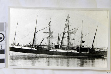
Black and White photograph of vessel S.S. Casino in calm water, taken 1882-1932. The coastal trader has light rigging and steam funnel, lifeboat on side, two men on deck. Background shows other ships. The S.S. Casino was a passenger and freight steamer built in Dundee, Scotland, in 1882 for the Newcastle and Hunter River Steam Navigation Company of N.S.W. She weighed 425 tons gross with a length of 160.4 feet, beam of 24.1 feet and depth of 10.2 feet. She had saloon accommodation for 35 people, forecabin for 25 more people, and she carried 300 tons of cargo. While on her delivery journey on May 30th 1882 the S.S. Casino called in at the Port of Warrnambool for coal ., narrowly escaping going ashore in gale force winds due to the quick action of the pilot. At that time, still at anchor, she impressed the directors of the Belfast and Koroit Steam Navigation Company so much that they bought her immediately; she was ideal for trade in along the West Coast of Victoria. (Belfast is the original name for Port Fairy, South West Victoria. The Belfast and Koroit Steam Navigation Company was first managed by Messers. Saltau and Osburne and after the passing of Mr. Osburne, by produce merchants Messers H. Sautau and Sons, whose had a hay and corn store and shipping agency was on the corner of Liebig and Koroit Streets in Warrnambool. ) The S.S. Casino became “the most famous steamer to operate in Victorian waters along the West Coast” by author Jack Loney. Captain Boyd was her first Master, followed by Captain Chapman, who stayed with her 1890 until 1924. Captain W. Robertson followed for a short term, then Captain Middleton then took command 1925 - 1932. The S.S. Casino had several mishaps during her life. One was on 3rd January 1898 when she collided with the S.S. Flinders in Apollo Bay with minor damage. Another was on 24th October 1924 when she grounded on a reef at Point Hawdon near Grey River and most of her cargo (of Christmas goods) had to be dumped into the sea. Then in February 1929 she was ‘holed’ when she struck a submerged object as she entered Lady Bay, Warrnambool. On the morning of 10th July 1932, after attempting to berth at Apollo Bay jetty in heavy seas, Captain Middleton decided to take her out into the bay and wait until the seas abated. It was not realised that the anchor used to steady her as she manoeuvred to her berth had pierced her hull. She put about and headed for the beach but sank. Captain Middleton and nine others lost their lives; nine people were rescued including the two female passengers . Captain Middleton had been in charge of the S.S. Casino for seven years. He was the first ship’s Master to lose his life through shipwreck in the West Coast trade. In the years following the turn of the century the S.S. Casino remained the only regular trader with normal passenger accommodation along the West Coast. From 1882 she had made at least 2,500 voyages on the one run. Flagstaff Hill’s collection has a photograph of a portrait of Captain Chapman, , a ship model of the S.S. Casino that shows both forms of power under which she sailed, steam and sail. The ship is painted green and flies three flags. The inscription across the case of the ship model, incorrectly dated, tells the sad story of the wreck of the ship and the loss of lives on July 10th 1932 at Apollo Bay. A print in the Collection show S.S. Casino underway in heavy sea off Point Lonsdale, another two photographs show her at the Port of Warrnambool, leaving from the Breakwater in Lady Bay and another identifies the S.S. Casino as a ship from the Belfast and Koroit Steam Navigation Company. (Belfast is the original name for the township of Port Fairy). This photograph was taken 1882-1932. It is significant because of its association with the coastal trader S.S. Casino and its significance to trade along Victoria's West Coast in the late 19th and early 20th century. The wreck of the S.S. Casino is considered an important part of Victorian and Australian cultural heritage and as such has been declared and protected as an Historic Shipwreck under State and Commonwealth Law in the Commonwealth Historic Shipwrecks Act (1976). Black and White photograph of vessel S.S. Casino in calm water, taken 1882-1932. The coastal trader has light rigging and steam funnel, lifeboat on side, two men on deck. Background shows other ships.flagstaff hill, warrnambool, shipwrecked coast, flagstaff hill maritime museum, maritime museum, shipwreck coast, flagstaff hill maritime village, great ocean road, newcastle and hunter river steam navigation company, belfast and koroit steam navigation company, h. sautau and sons, s.s. casino, west coast trader s.s. casino, victorian coastal trader, captain boyd, captain w. robertson, captain chapman, captain middleton, apollo bay shipwreck, s.s. casino at lady bay warrnambool, saltau and osburne -
 Flagstaff Hill Maritime Museum and Village
Photograph
Black and White Photograph of S.S Casino arriving in port, taken 1930-1932. Decks are laden with men and women , crowd of waving people along the river bank, smoke coming from funnel. Warehouse and homes in the background. The S.S. Casino was a passenger and freight steamer built in Dundee, Scotland, in 1882 for the Newcastle and Hunter River Steam Navigation Company of N.S.W. She weighed 425 tons gross with a length of 160.4 feet, beam of 24.1 feet and depth of 10.2 feet. She had saloon accommodation for 35 people, forecabin for 25 more people, and she carried 300 tons of cargo. While on her delivery journey on May 30th 1882 the S.S. Casino called in at the Port of Warrnambool for coal ., narrowly escaping going ashore in gale force winds due to the quick action of the pilot. At that time, still at anchor, she impressed the directors of the Belfast and Koroit Steam Navigation Company so much that they bought her immediately; she was ideal for trade in along the West Coast of Victoria. (Belfast is the original name for Port Fairy, South West Victoria. The Belfast and Koroit Steam Navigation Company was first managed by Messers. Saltau and Osburne and after the passing of Mr. Osburne, by produce merchants Messers H. Sautau and Sons, whose had a hay and corn store and shipping agency was on the corner of Liebig and Koroit Streets in Warrnambool. ) The S.S. Casino became “the most famous steamer to operate in Victorian waters along the West Coast” by author Jack Loney. Captain Boyd was her first Master, followed by Captain Chapman, who stayed with her 1890 until 1924. Captain W. Robertson followed for a short term, then Captain Middleton then took command 1925 - 1932. The S.S. Casino had several mishaps during her life. One was on 3rd January 1898 when she collided with the S.S. Flinders in Apollo Bay with minor damage. Another was on 24th October 1924 when she grounded on a reef at Point Hawdon near Grey River and most of her cargo (of Christmas goods) had to be dumped into the sea. Then in February 1929 she was ‘holed’ when she struck a submerged object as she entered Lady Bay, Warrnambool. On the morning of 10th July 1932, after attempting to berth at Apollo Bay jetty in heavy seas, Captain Middleton decided to take her out into the bay and wait until the seas abated. It was not realised that the anchor used to steady her as she manoeuvred to her berth had pierced her hull. She put about and headed for the beach but sank. Captain Middleton and nine others lost their lives; nine people were rescued including the two female passengers . Captain Middleton had been in charge of the S.S. Casino for seven years. He was the first ship’s Master to lose his life through shipwreck in the West Coast trade. In the years following the turn of the century the S.S. Casino remained the only regular trader with normal passenger accommodation along the West Coast. From 1882 she had made at least 2,500 voyages on the one run. Flagstaff Hill’s collection has a photograph of a portrait of Captain Chapman, , a ship model of the S.S. Casino that shows both forms of power under which she sailed, steam and sail. The ship is painted green and flies three flags. The inscription across the case of the ship model, incorrectly dated, tells the sad story of the wreck of the ship and the loss of lives on July 10th 1932 at Apollo Bay. A print in the Collection show S.S. Casino underway in heavy sea off Point Lonsdale, another two photographs show her at the Port of Warrnambool, leaving from the Breakwater in Lady Bay and another identifies the S.S. Casino as a ship from the Belfast and Koroit Steam Navigation Company. (Belfast is the original name for the township of Port Fairy). This photograph is significant because of its association with the coastal trader S.S. Casino 1882-1932 and its significance to trade along Victoria's West Coast in the late 19th and early 20th century. The wreck of the S.S. Casino is considered an important part of Victorian and Australian cultural heritage and as such has been declared and protected as an Historic Shipwreck under State and Commonwealth Law in the Commonwealth Historic Shipwrecks Act (1976). Black and White Photograph of S.S Casino arriving in port, taken 1930-1932. Decks are laden with men and women , crowd of waving people along the river bank, smoke coming from funnel. Warehouse and homes in the background. flagstaff hill, warrnambool, shipwrecked coast, flagstaff hill maritime museum, maritime museum, shipwreck coast, flagstaff hill maritime village, great ocean road, newcastle and hunter river steam navigation company, belfast and koroit steam navigation company, h. sautau and sons, s.s. casino, west coast trader s.s. casino, victorian coastal trader, captain boyd, captain w. robertson, captain chapman, captain middleton, apollo bay shipwreck, s.s. casino at lady bay warrnambool, saltau and osburne -
 Flagstaff Hill Maritime Museum and Village
Photograph
Black and White Photograph of S.S Casino taken 1930-1932. The Casino is berthed at the Warrnambool Breakwater, either loading or unloading. A person is attending a container at the bottom of a ramp between ship to Breakwater. People are sitting or standing on the Breakwater. The S.S. Casino was a passenger and freight steamer built in Dundee, Scotland, in 1882 for the Newcastle and Hunter River Steam Navigation Company of N.S.W. She weighed 425 tons gross with a length of 160.4 feet, beam of 24.1 feet and depth of 10.2 feet. She had saloon accommodation for 35 people, forecabin for 25 more people, and she carried 300 tons of cargo. While on her delivery journey on May 30th 1882 the S.S. Casino called in at the Port of Warrnambool for coal ., narrowly escaping going ashore in gale force winds due to the quick action of the pilot. At that time, still at anchor, she impressed the directors of the Belfast and Koroit Steam Navigation Company so much that they bought her immediately; she was ideal for trade in along the West Coast of Victoria. (Belfast is the original name for Port Fairy, South West Victoria. The Belfast and Koroit Steam Navigation Company was first managed by Messers. Saltau and Osburne and after the passing of Mr. Osburne, by produce merchants Messers H. Sautau and Sons, whose had a hay and corn store and shipping agency was on the corner of Liebig and Koroit Streets in Warrnambool. ) The S.S. Casino became “the most famous steamer to operate in Victorian waters along the West Coast” by author Jack Loney. Captain Boyd was her first Master, followed by Captain Chapman, who stayed with her 1890 until 1924. Captain W. Robertson followed for a short term, then Captain Middleton then took command 1925 - 1932. The S.S. Casino had several mishaps during her life. One was on 3rd January 1898 when she collided with the S.S. Flinders in Apollo Bay with minor damage. Another was on 24th October 1924 when she grounded on a reef at Point Hawdon near Grey River and most of her cargo (of Christmas goods) had to be dumped into the sea. Then in February 1929 she was ‘holed’ when she struck a submerged object as she entered Lady Bay, Warrnambool. On the morning of 10th July 1932, after attempting to berth at Apollo Bay jetty in heavy seas, Captain Middleton decided to take her out into the bay and wait until the seas abated. It was not realised that the anchor used to steady her as she manoeuvred to her berth had pierced her hull. She put about and headed for the beach but sank. Captain Middleton and nine others lost their lives; nine people were rescued including the two female passengers . Captain Middleton had been in charge of the S.S. Casino for seven years. He was the first ship’s Master to lose his life through shipwreck in the West Coast trade. In the years following the turn of the century the S.S. Casino remained the only regular trader with normal passenger accommodation along the West Coast. From 1882 she had made at least 2,500 voyages on the one run. Flagstaff Hill’s collection has a photograph of a portrait of Captain Chapman, , a ship model of the S.S. Casino that shows both forms of power under which she sailed, steam and sail. The ship is painted green and flies three flags. The inscription across the case of the ship model, incorrectly dated, tells the sad story of the wreck of the ship and the loss of lives on July 10th 1932 at Apollo Bay. A print in the Collection show S.S. Casino underway in heavy sea off Point Lonsdale, another two photographs show her at the Port of Warrnambool, leaving from the Breakwater in Lady Bay and another identifies the S.S. Casino as a ship from the Belfast and Koroit Steam Navigation Company. (Belfast is the original name for the township of Port Fairy). This object is significant because of its association with the coastal trader S.S. Casino 1882-1932 and its significance to trade along Victoria's West Coast in the late 19th and early 20th century. The wreck of the S.S. Casino is considered an important part of Victorian and Australian cultural heritage and as such has been declared and protected as an Historic Shipwreck under State and Commonwealth Law in the Commonwealth Historic Shipwrecks Act (1976). Black and White Photograph of S.S Casino taken 1930-1932. The Casino is berthed at the Warrnambool Breakwater, either loading or unloading. A person is attending a container at the bottom of a ramp between ship to Breakwater. People are sitting or standing on the Breakwater.flagstaff hill, warrnambool, shipwrecked coast, flagstaff hill maritime museum, maritime museum, shipwreck coast, flagstaff hill maritime village, great ocean road, newcastle and hunter river steam navigation company, belfast and koroit steam navigation company, h. sautau and sons, s.s. casino, west coast trader s.s. casino, victorian coastal trader, captain boyd, captain w. robertson, captain chapman, captain middleton, apollo bay shipwreck, s.s. casino at lady bay warrnambool, saltau and osburne -
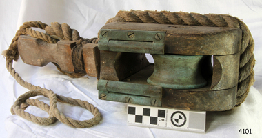 Flagstaff Hill Maritime Museum and Village
Equipment - Traveller pulley block, 1860s
The life saving breeches buoy was attached to a traveller block such as this one. The assembly was sent from shore to ship and back to transport the stranded people and goods safely to shore. Saving lives in Warrnambool – The coastline of South West Victoria is the site of over 600 shipwrecks and many lost lives; even in Warrnambool’s Lady Bay there were around 16 known shipwrecks between 1850 and 1905, with eight lives lost. Victoria’s Government responded to the need for lifesaving equipment and, in 1858, the provision of rocket and mortar apparatus was approved for the lifeboat stations. In 1859 the first Government-built lifeboat arrived at Warrnambool Harbour and a shed was soon built for it on the Tramway Jetty, followed by a rocket house in 1864 to safely store the rocket rescue equipment. In 1878 the buildings were moved to the Breakwater (constructed from 1874-1890), and in 1910 the new Lifeboat Warrnambool arrived with its ‘self-righting’ design. For almost a hundred years the lifesaving and rescue crews, mostly local volunteers, trained regularly to rehearse and maintain their rescue skills. They were summoned when needed by alarms, gunshots, ringing bells and foghorns. In July 1873 a brass bell was erected at Flagstaff Hill specifically to call the rescue crew upon news of a shipwreck. Some crew members became local heroes but all served an important role. Rocket apparatus was used as recently as the 1950s. Rocket Rescue Method - Rocket rescue became the preferred lifesaving method of the rescue crews, being much safer that using a lifeboat in rough seas and poor conditions. The Government of Victoria adopted lifesaving methods based on Her Majesty’s Coast Guard in Great Britain. It authorised the first line-throwing rescue system in 1858. Captain Manby’s mortar powered a projectile connected to rope, invented in 1808. The equipment was updated to John Dennett’s 8-foot shaft and rocket method that had a longer range of about 250 yards. From the 1860s the breeches buoy and traveller block rocket rescue apparatus was in use. It was suspended on a hawser line and manually pulled to and from the distressed vessel carrying passengers and items. In the early 1870s Colonel Boxer’s rocket rescue method became the standard in Victoria. His two-stage rockets, charged by a gunpowder composition, could fire the line up to 500-600 yards, although 1000 yards range was possible. Boxer’s rocket carried the light line, which was faked, or coiled, in a particular way between pegs in a faking box to prevent twists and tangles when fired. The angle of firing the rocket to the vessel in distress was measured by a quadrant-type instrument on the side of the rocket machine. Decades later, in 1920, Schermuly invented the line-throwing pistol that used a small cartridge to fire the rocket. . The British Board of Trade regularly published instructions for both the beach rescue crew and ship’s crew. It involved setting up the rocket launcher on shore at a particular angle, determined by the Head of the crew and measured by the quadrant, inserting a rocket that had a light-weight line threaded through its shaft, and then firing it across the stranded vessel, the line issuing freely from the faking board. A continuous whip line was then sent out to the ship’s crew, who hauled it in then followed the instructions – in four languages - on the attached tally board. The survivors would haul on the line to bring out the heavier, continuous whip line with a tail block connected to it. They then secured the block to the mast or other strong part the ship. The rescue crew on shore then hauled out a stronger hawser line, which the survivors fixed above the whip’s tail block. The hawser was then tightened by the crew pulling on it, or by using the hooked block on the shore end of the whip and attaching it to a sand anchor. The breeches buoy was attached to the traveller block on the hawser, and the shore crew then used the whip line to haul the breeches buoy to and from the vessel, rescuing the stranded crew one at a time. The rescue crew wore scarlet, numbered armbands and worked on a numerical rotation system, swapping members out to rest them.This traveller block is significant for its connection with local history, maritime history and marine technology. Lifesaving has been an important part of the services performed from Warrnambool's very early days, supported by State and Local Government, and based on the methods and experience of Great Britain. Hundreds of shipwrecks along the coast are evidence of the rough weather and rugged coastline. Ordinary citizens, the Harbour employees, and the volunteer boat and rescue crew, saved lives in adverse circumstances. Some were recognised as heroes, others went unrecognised. In Lady Bay, Warrnambool, there were around 16 known shipwrecks between 1850 and 1905. Many lives were saved but tragically, eight lives were lost. Wood and brass pulley block or 'traveller', used in conjunction with the Breeches Buoy. The block has double brass inline sheaves and brass rollers on each cheek of the pulley. Each shell is scored for the strop. The thimble on the strop has a wooden slat attached for quick release of the Breeches Buoy. A portion of rope is connected.flagstaff hill maritime museum and village, flagstaff hill, maritime museum, maritime village, warrnambool, shipwreck, life-saving, lifesaving, rescue crew, rescue, rocket rescue, rocket crew, lifeboat men, beach rescue, line rescue, rescue equipment, rocket firing equipment, rocket rescue equipment, maritime accidents, shipwreck victim, rocket equipment, marine technology, rescue boat, lifeboat, volunteer lifesavers, volunteer crew, life saving rescue crew, lifesaving rescue crew, rocket apparatus, rocket rescue method, shore to ship, rocket apparatus rescue, stranded vessel, line throwing mortar, mortar, rocket rescue apparatus, line thrower, line throwing, lifeboat warrnambool, beach apparatus, breeches buoy, petticoat breeches, petticoat buoy, traveller chair, life jacket, traveller, traveller block, running block, block, pulley, hawser, faking, faking box, faked line, faking board, italian hemp, quadrant, protractor, tally board, light line, whip line, endless whip, beach cart, hand barrow, sand anchor, welsh hand barrow, her majesty’s coast guard, harbour board, government of victoria, harbour master, l.s.r.c., lsrc -
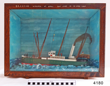 Flagstaff Hill Maritime Museum and Village
Craft - Ship Model, S.S. Casino
Ship model of coastal trader SS Casino in glass fronted case with stained wood frame. Ship has both steam and sail. Background of lighthouse on cliff, sea and sky. Ship painted green, 3 flags flying. Details (incorrect) of ship painted in white across top frame of case. The S.S. Casino was a passenger and freight steamer built in Dundee, Scotland, in 1882 for the Newcastle and Hunter River Steam Navigation Company of N.S.W. She weighed 425 tons gross with a length of 160.4 feet, beam of 24.1 feet and depth of 10.2 feet. She had saloon accommodation for 35 people, forecabin for 25 more people, and she carried 300 tons of cargo. While on her delivery journey on May 30th 1882 the S.S. Casino called in at the Port of Warrnambool for coal ., narrowly escaping going ashore in gale force winds due to the quick action of the pilot. At that time, still at anchor, she impressed the directors of the Belfast and Koroit Steam Navigation Company so much that they bought her immediately; she was ideal for trade in along the West Coast of Victoria. (Belfast is the original name for Port Fairy, South West Victoria. The Belfast and Koroit Steam Navigation Company was first managed by Messers. Saltau and Osburne and after the passing of Mr. Osburne, by produce merchants Messers H. Sautau and Sons, whose had a hay and corn store and shipping agency was on the corner of Liebig and Koroit Streets in Warrnambool. ) The S.S. Casino became “the most famous steamer to operate in Victorian waters along the West Coast” by author Jack Loney. Captain Boyd was her first Master, followed by Captain Chapman, who stayed with her 1890 until 1924. Captain W. Robertson followed for a short term, then Captain Middleton then took command 1925 - 1932. The S.S. Casino had several mishaps during her life. One was on 3rd January 1898 when she collided with the S.S. Flinders in Apollo Bay with minor damage. Another was on 24th October 1924 when she grounded on a reef at Point Hawdon near Grey River and most of her cargo (of Christmas goods) had to be dumped into the sea. Then in February 1929 she was ‘holed’ when she struck a submerged object as she entered Lady Bay, Warrnambool. On the morning of 10th July 1932, after attempting to berth at Apollo Bay jetty in heavy seas, Captain Middleton decided to take her out into the bay and wait until the seas abated. It was not realised that the anchor used to steady her as she manoeuvred to her berth had pierced her hull. She put about and headed for the beach but sank. Captain Middleton and nine others lost their lives; nine people were rescued including the two female passengers . Captain Middleton had been in charge of the S.S. Casino for seven years. He was the first ship’s Master to lose his life through shipwreck in the West Coast trade. In the years following the turn of the century the S.S. Casino remained the only regular trader with normal passenger accommodation along the West Coast. From 1882 she had made at least 2,500 voyages on the one run. Flagstaff Hill’s collection has a photograph of a portrait of Captain Chapman, , a ship model of the S.S. Casino that shows both forms of power under which she sailed, steam and sail. The ship is painted green and flies three flags. The inscription across the case of the ship model, incorrectly dated, tells the sad story of the wreck of the ship and the loss of lives on July 10th 1932 at Apollo Bay. A print in the Collection show S.S. Casino underway in heavy sea off Point Lonsdale, another two photographs show her at the Port of Warrnambool, leaving from the Breakwater in Lady Bay and another identifies the S.S. Casino as a ship from the Belfast and Koroit Steam Navigation Company. (Belfast is the original name for the township of Port Fairy). This ship model is significant because of its association with the coastal trader S.S. Casino 1882-1932 and its significance to trade along Victoria's West Coast in the late 19th and early 20th century. The wreck of the S.S. Casino is considered an important part of Victorian and Australian cultural heritage and as such has been declared and protected as an Historic Shipwreck under State and Commonwealth Law in the Commonwealth Historic Shipwrecks Act (1976). Ship model SS Casino in glass fronted case with stained wood frame. Ship has both steam and sail. Background of lighthouse on cliff, sea and sky. Ship painted green, 3 flags flying. Details of ship painted in white across top frame of case. NOTE: Correct details for shipwreck is 10 July 1932, at Apollo BayPainted in white on wood across top of case "SS CASINO WRECKED AT APOLL BAY JUNE 10 10 LIVES LOST".flagstaff hill, warrnambool, shipwrecked coast, flagstaff hill maritime museum, maritime museum, shipwreck coast, flagstaff hill maritime village, great ocean road, newcastle and hunter river steam navigation company, belfast and koroit steam navigation company, h. sautau and sons, s.s. casino, west coast trader s.s. casino, victorian coastal trader, captain boyd, captain w. robertson, captain chapman, captain middleton, apollo bay shipwreck, s.s. casino at lady bay warrnambool, ship model s.s. casino, saltau and osburne -
 Flagstaff Hill Maritime Museum and Village
Equipment - Rocket Key, John Dennett, c. 1860s
This rocket launcher key was used with the Dennett's Rocket Launcher system to remove the end cap of the Dennett's Rocket to expose the propellant to be fused . Saving lives in Warrnambool – The coastline of South West Victoria is the site of over 600 shipwrecks and many lost lives; even in Warrnambool’s Lady Bay there were around 16 known shipwrecks between 1850 and 1905, with eight lives lost. Victoria’s Government responded to the need for lifesaving equipment and, in 1858, the provision of rocket and mortar apparatus was approved for the lifeboat stations. In 1859 the first Government-built lifeboat arrived at Warrnambool Harbour and a shed was soon built for it on the Tramway Jetty, followed by a rocket house in 1864 to safely store the rocket rescue equipment. In 1878 the buildings were moved to the Breakwater (constructed from 1874-1890), and in 1910 the new Lifeboat Warrnambool arrived with its ‘self-righting’ design. For almost a hundred years the lifesaving and rescue crews, mostly local volunteers, trained regularly to rehearse and maintain their rescue skills. They were summoned when needed by alarms, gunshots, ringing bells and foghorns. In July 1873 a brass bell was erected at Flagstaff Hill specifically to call the rescue crew upon news of a shipwreck. Some crew members became local heroes but all served an important role. Rocket apparatus was used as recently as the 1950s. Rocket Rescue Method - Rocket rescue became the preferred lifesaving method of the rescue crews, being much safer that using a lifeboat in rough seas and poor conditions. The Government of Victoria adopted lifesaving methods based on Her Majesty’s Coast Guard in Great Britain. It authorised the first line-throwing rescue system in 1858. Captain Manby’s mortar powered a projectile connected to rope, invented in 1808. The equipment was updated to John Dennett’s 8-foot shaft and rocket method that had a longer range of about 250 yards. From the 1860s the breeches buoy and traveller block rocket rescue apparatus was in use. It was suspended on a hawser line and manually pulled to and from the distressed vessel carrying passengers and items. In the early 1870s Colonel Boxer’s rocket rescue method became the standard in Victoria. His two-stage rockets, charged by a gunpowder composition, could fire the line up to 500-600 yards, although 1000 yards range was possible. Boxer’s rocket carried the light line, which was faked, or coiled, in a particular way between pegs in a faking box to prevent twists and tangles when fired. The angle of firing the rocket to the vessel in distress was measured by a quadrant-type instrument on the side of the rocket machine. Decades later, in about 1920, Schermuly invented the line-throwing pistol that used a small cartridge to fire the rocket. . The British Board of Trade regularly published instructions for both the beach rescue crew and ship’s crew. It involved setting up the rocket launcher on shore at a particular angle, determined by the Head of the crew and measured by the quadrant, inserting a rocket that had a light-weight line threaded through its shaft, and then firing it across the stranded vessel, the line issuing freely from the faking board. A continuous whip line was then sent out to the ship’s crew, who hauled it in then followed the instructions – in four languages - on the attached tally board. The survivors would haul on the line to bring out the heavier, continuous whip line with a tail block connected to it. They then secured the block to the mast or other strong part the ship. The rescue crew on shore then hauled out a stronger hawser line, which the survivors fixed above the whip’s tail block. The hawser was then tightened by the crew pulling on it, or by using the hooked block on the shore end of the whip and attaching it to a sand anchor. The breeches buoy was attached to the traveller block on the hawser, and the shore crew then used the whip line to haul the breeches buoy to and from the vessel, rescuing the stranded crew one at a time. The rescue crew wore scarlet, numbered armbands and worked on a numerical rotation system, swapping members out to rest them. This rocket launcher key is a necessary part of the equipment for the the rocket launcher, which is significant for its connection with local history, maritime history and marine technology. Lifesaving has been an important part of the services performed from Warrnambool's very early days, supported by State and Local Government, and based on the methods and experience of Great Britain. Hundreds of shipwrecks along the coast are evidence of the rough weather and rugged coastline. Ordinary citizens, the Harbour employees, and the volunteer boat and rescue crew, saved lives in adverse circumstances. Some were recognised as heroes, others went unrecognised. In Lady Bay, Warrnambool, there were around 16 known shipwrecks between 1850 and 1905. Many lives were saved but tragically, eight lives were lost.Key, part of the Rocket Rescue equipment. T shaped metal key, round handle across the top and hexagonal shaped shaft and square end. Used to remove the end cap of the Dennett's Rocket to expose the propellant to be fused . Donation from Ports and Harbour.flagstaff hill maritime museum and village, flagstaff hill, maritime museum, maritime village, warrnambool, great ocean road, lady bay, warrnambool harbour, port of warrnambool, tramway jetty, breakwater, shipwreck, life-saving, lifesaving, rescue crew, rescue, rocket rescue, rocket crew, lifeboat men, beach rescue, line rescue, rescue equipment, rocket firing equipment, rocket rescue equipment, maritime accidents, shipwreck victim, rocket equipment, marine technology, rescue boat, lifeboat, volunteer lifesavers, volunteer crew, life saving rescue crew, lifesaving rescue crew, rocket apparatus, rocket rescue method, shore to ship, rocket apparatus rescue, stranded vessel, line throwing mortar, mortar, rocket rescue apparatus, line thrower, line throwing, lifeboat warrnambool, rocket house, rocket shed, rocket machine, rocket head, rocket launcher, rocket line, beach rescue set, rocket set, john dennett, rocket key, rocket launcher key, life saving -
 Flagstaff Hill Maritime Museum and Village
Equipment - Line faking box, Government of Victoria, 1860s
The rocket line faking box with lid has a frame inside with a specifically designed perimeter of faking pegs. The rocket shot line has been faked, or skilful wound, around these pegs to prevent it from tangling. The line is stored in the box, ready for attaching to the line throwing rocket. Some line faking boxes have a false base that is removed before firing the line-throwing pistol, leaving the line to feed out from the box when the rocket is fired. After the line is attached to the rocket the box tilted slightly and faced towards the wreck to allow it to be freely dispatched. The equipment often includes more that one faking box to make allowance for possible errors, broken lines or the need for a heavier line. Saving lives in Warrnambool – The coastline of South West Victoria is the site of over 600 shipwrecks and many lost lives; even in Warrnambool’s Lady Bay there were around 16 known shipwrecks between 1850 and 1905, with eight lives lost. In 1859 the first Government-built lifeboat arrived at Warrnambool Harbour and a shed was soon built to house it. In 1858 the provision of rocket and mortar apparatus was approved for lifeboat stations in Victoria, and in 1864 a rocket house was built to safely store the rocket rescue equipment. In 1878 the buildings were moved to the Breakwater area, and in 1910 the new Lifeboat Warrnambool arrived with its ‘self-righting’ design. For almost a hundred years the lifeboat and rocket crews, mostly local volunteers, trained regularly to maintain their rescue skills. They were summoned when needed by alarms, gunshots, ringing bells and foghorns. Some became local heroes but all served an important role. By the end of the 1950s the lifeboat and rescue equipment had become obsolete. Rocket Rescue Method - The Government of Victoria adopted lifesaving methods based on Her Majesty’s Coast Guard in Great Britain. It authorised the first line-throwing rescue system in 1858. Captain Manby’s mortar powered a projectile connected to rope, invented in 1808. The equipment was updated to John Dennett’s 8-foot shaft and rocket method that had a longer range of about 250 yards. From the 1860s the breeches buoy and traveller block rocket rescue apparatus was in use. It was suspended on a hawser line and manually pulled to and from the distressed vessel carrying passengers and items. In the early 1870s Colonel Boxer’s rocket rescue method became the standard in Victoria. His two-stage rockets, charged by a gunpowder composition, could fire the line up to 500-600 yards, although 1000 yards range was possible. Boxer’s rocket carried the light line, which was faked, or coiled, in a particular way between pegs in a faking box to prevent twists and tangles when fired. The angle of firing the rocket to the vessel in distress was measured by a quadrant-type instrument on the side of the rocket machine. Decades later, in about 1920, Schermuly invented the line-throwing pistol that used a small cartridge to fire the rocket. The British Board of Trade published instructions for both the beach rescue crew and ship’s crew. It involved setting up the rocket launcher on shore at a particular angle measured by the quadrant, inserting a rocket that had a light-weight line threaded through its shaft, and then firing it across the stranded vessel, the line issuing freely from the faking board. A tally board was then sent out to the ship with instructions in four languages. The ship’s crew would haul on the line to bring out the heavier, continuous whip line, then secure the attached whip block to the mast or other sturdy part the ship. The rescue crew on shore then hauled out a stronger hawser line, which the ship’s crew fixed above the whip block. The hawser was then tightened using the block on the shore end of the whip. The breeches buoy and endless whip are then attached to the traveller block on the hawser, allowing the shore crew to haul the breeches buoy to and from the vessel, rescuing the stranded crew one at a time. This rocket line faking box is significant for its connection with local history, maritime history and marine technology. Lifesaving has been an important part of the services performed from Warrnambool's very early days, supported by State and Local Government, and based on the methods and experience of Great Britain. Hundreds of shipwrecks along the coast are evidence of the rough weather and rugged coastline. Ordinary citizens, the Harbour employees, and the volunteer boat and rescue crew, saved lives in adverse circumstances. Some were recognised as heroes, others went unrecognised. In Lady Bay, Warrnambool, there were around 16 known shipwrecks between 1850 and 1905. Many lives were saved but tragically, eight lives were lost.Rocket line faking box with loose fitting lid, painted blue on the outside. Rectangular box has two rope handles within wooden rope holders fixed onto each long side and one at each end. The box has a hook and ring at the base each end for releasing the top from the inserted faking frame. The line faking frame is inside the box. It has seventeen wooden pegs along each long side of the frame and three pegs along each short side. A continuous length of rocket line has been faked around the pegs in a specific pattern.flagstaff hill maritime museum & village, flagstaff hill, maritime museum, maritime village, warrnambool, great ocean road, shipwreck, life-saving, lifesaving, rescue crew, rescue, rocket rescue, maritime accidents, rocket crew, beach rescue, line rescue, rescue equipment, rocket firing equipment, rocket rescue equipment, rocket apparatus, beach apparatus, petticoat breeches, breeches buoy, rocket house, rocket shed, lifeboat men, rocket equipment, rocket machine, rocket head, rocket launcher, rocket line, marine technology, line-firing pistol, line throwing gun, beach rescue set, traveller, hawser, faking, faking box, faked line, lady bay, warrnambool harbour, port of warrnambool, volunteer lifesavers, volunteer crew, breakwater, lifeboat warrnambool, rocket rescue method, rocket rescue apparatus, shore to ship, italian hemp, line-throwing pistol, line throwing cartridge, rocket apparatus rescue, stranded vessel, tally board, light line, whip line, endless whip, petticoat buoy, traveller chair, traveller block, her majesty’s coast guard, harbour board, line thrower, line throwing, beach cart, hand barrow, sand anchor, hawser cutter, life jacket, faking board, welsh hand barrow, rocket set, rocket line faking box, faking frame -
 Flagstaff Hill Maritime Museum and Village
Equipment - Line faking box, Government of Victoria, 1860s
The rocket line faking box has a frame inside with a specifically designed perimeter of faking pegs. The rocket shot line has been faked, or skilful wound, around these pegs to prevent it from tangling. The line is stored in the box, ready for attaching to the line throwing rocket. Some line faking boxes have a false base that is removed before firing the line-throwing pistol, leaving the line to feed out from the box when the rocket is fired. After the line is attached to the rocket the box tilted slightly and faced towards the wreck to allow it to be freely dispatched. The equipment often includes more that one faking box to make allowance for possible errors, broken lines or the need for a heavier line. Saving lives in Warrnambool – The coastline of South West Victoria is the site of over 600 shipwrecks and many lost lives; even in Warrnambool’s Lady Bay there were around 16 known shipwrecks between 1850 and 1905, with eight lives lost. In 1859 the first Government-built lifeboat arrived at Warrnambool Harbour and a shed was soon built to house it. In 1858 the provision of rocket and mortar apparatus was approved for lifeboat stations in Victoria, and in 1864 a rocket house was built to safely store the rocket rescue equipment. In 1878 the buildings were moved to the Breakwater area, and in 1910 the new Lifeboat Warrnambool arrived with its ‘self-righting’ design. For almost a hundred years the lifeboat and rocket crews, mostly local volunteers, trained regularly to maintain their rescue skills. They were summoned when needed by alarms, gunshots, ringing bells and foghorns. Some became local heroes but all served an important role. By the end of the 1950s the lifeboat and rescue equipment had become obsolete. Rocket Rescue Method - The Government of Victoria adopted lifesaving methods based on Her Majesty’s Coast Guard in Great Britain. It authorised the first line-throwing rescue system in 1858. Captain Manby’s mortar powered a projectile connected to rope, invented in 1808. The equipment was updated to John Dennett’s 8-foot shaft and rocket method that had a longer range of about 250 yards. From the 1860s the breeches buoy and traveller block rocket rescue apparatus was in use. It was suspended on a hawser line and manually pulled to and from the distressed vessel carrying passengers and items. In the early 1870s Colonel Boxer’s rocket rescue method became the standard in Victoria. His two-stage rockets, charged by a gunpowder composition, could fire the line up to 500-600 yards, although 1000 yards range was possible. Boxer’s rocket carried the light line, which was faked, or coiled, in a particular way between pegs in a faking box to prevent twists and tangles when fired. The angle of firing the rocket to the vessel in distress was measured by a quadrant-type instrument on the side of the rocket machine. Decades later, in about 1920, Schermuly invented the line-throwing pistol that used a small cartridge to fire the rocket. The British Board of Trade published instructions for both the beach rescue crew and ship’s crew. It involved setting up the rocket launcher on shore at a particular angle measured by the quadrant, inserting a rocket that had a light-weight line threaded through its shaft, and then firing it across the stranded vessel, the line issuing freely from the faking board. A tally board was then sent out to the ship with instructions in four languages. The ship’s crew would haul on the line to bring out the heavier, continuous whip line, then secure the attached whip block to the mast or other sturdy part the ship. The rescue crew on shore then hauled out a stronger hawser line, which the ship’s crew fixed above the whip block. The hawser was then tightened using the block on the shore end of the whip. The breeches buoy and endless whip are then attached to the traveller block on the hawser, allowing the shore crew to haul the breeches buoy to and from the vessel, rescuing the stranded crew one at a time. This rocket line faking box is significant for its connection with local history, maritime history and marine technology. Lifesaving has been an important part of the services performed from Warrnambool's very early days, supported by State and Local Government, and based on the methods and experience of Great Britain. Hundreds of shipwrecks along the coast are evidence of the rough weather and rugged coastline. Ordinary citizens, the Harbour employees, and the volunteer boat and rescue crew, saved lives in adverse circumstances. Some were recognised as heroes, others went unrecognised. In Lady Bay, Warrnambool, there were around 16 known shipwrecks between 1850 and 1905. Many lives were saved but tragically, eight lives were lost.Rocket line faking box with loose fitting lid, painted black on the outside. Rectangular box has two rope handles within wooden rope holders fixed onto each long side and one at each end. The box has a hook and ring at the base each end for releasing the top from the inserted faking frame. The line faking frame is inside the box. It has seventeen wooden pegs along each long side of the frame and three pegs along each short side. A continuous length of rocket line has been faked around the pegs in a specific pattern.flagstaff hill maritime museum & village, flagstaff hill, maritime museum, maritime village, warrnambool, great ocean road, shipwreck, life-saving, lifesaving, rescue crew, rescue, rocket rescue, maritime accidents, rocket crew, beach rescue, line rescue, rescue equipment, rocket firing equipment, rocket rescue equipment, rocket apparatus, beach apparatus, petticoat breeches, breeches buoy, rocket house, rocket shed, lifeboat men, rocket equipment, rocket machine, rocket head, rocket launcher, rocket line, marine technology, line-firing pistol, line throwing gun, beach rescue set, traveller, hawser, faking, faking box, faked line, lady bay, warrnambool harbour, port of warrnambool, volunteer lifesavers, volunteer crew, breakwater, lifeboat warrnambool, rocket rescue method, rocket rescue apparatus, shore to ship, italian hemp, line-throwing pistol, line throwing cartridge, rocket apparatus rescue, stranded vessel, tally board, light line, whip line, endless whip, petticoat buoy, traveller chair, traveller block, her majesty’s coast guard, harbour board, line thrower, line throwing, beach cart, hand barrow, sand anchor, hawser cutter, life jacket, faking board, welsh hand barrow, rocket set, rocket line faking box, faking frame -
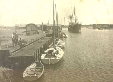 Port Fairy Historical Society Museum and Archives
Photograph
The steamer S.S.CASINO was much loved by the whole Port Fairy community- with the possible exception of some of the fishermen whose boats she ran down! Transport of the large quantities of wool, potatoes, onions, grain, sheep, cattle and other produce grown on the rich lands of the Western District Belfast was served by a plethora of shipping, both sail and steam, but only one of the steamers then in the regular trade (S.S. DAWN) would ever be able to get up the river and reap the cost savings of loading against a wharf. It was not unusual for four steamers to be anchored in the bay at once and for seven or eight different steamers to call during a week. A number of inter-colonial steamers also called to pick up produce for delivery to Melbourne, Sydney and Adelaide. Production in the Western District was increasing and virtually all of that production had to go through one of the western ports in order to reach markets. By 1882 a meeting 15ft. March, 1882, in the office of auctioneer, J.B. HoIden in Cox Street took action and it was unanimously resolved - that the Belfast & Koroit Steamship Company be formed with a capital of £20,000 in 10,000 shares of £2 each". A number of steamers were offered by letter to the fledgling company, including the new and almost sister ships, CASINO and HELEN NICHOLL. The CASINO was on her delivery voyage from England was due to arrive in Warrnambool to load potatoes for Sydney and, initially, arrangements were made for her to call into Port Fairy for inspection by the BKNS Co directors. She eventually proceeded direct to Warrnambool and the Directors inspected her there. Without hesitation they purchased her even though they had to raise a large bank loan to do so. The CASINO arrived in Port Fairy on Saturday, 29th. July, 1882, steaming triumphantly up the Moyne River, and was greeted by crowds, many of whom had driven in from the surrounding countryside, which gave her “loud ringing English cheers". By 1884 the CASINO could not carry all the cargoes available to her and in December of that year the company purchased the new steamer BELLINGER to provide additional capacity. She helped to open up the intermediate ports of Lorne, Apollo Bay and Port Campbell, but the BELLINGER was not really suitable for the trade and she was sold in 1887, leaving the CASINO to operate alone -as she was to do for almost all of the next 45 years. The opening of the railway in 1890 decreased the cargo available to the steamers and the economic depression of the early 1890's worsened the situation. The weak soon began to fall by the wayside and when the Portland & Belfast SN Co. decided to go into liquidation in April 1895, the Belfast & Koroit Company bought the Portland Company's steamer DAWN on advantageous terms, a substantial part of the payment being in BKSN Co shares. The BKNS Co and the Howard Smith Line came into direct head to head competition and nearly forced the BKNS Co out of existence. Cargo dropped to such an extent that in 1899, they reached agreement that only one ship would run and that the ship which ran would pay a weekly amount to the competitor to stay out of the trade. This controlled service ceased in1909, and competition intensified when Howard Smith placed the newly built, larger steamer EUMERALLA on the run. The BKNS Co survived this competition and even prospered during it partly by extending on a more regular basis, the CASINO'S voyages to South Australian ports Port Macdonnell, Kingston, Beachport, Robe and, on occasions Adelaide. There were setbacks when, on 20 October 1924, CASINO went ashore at the Kennett River, near Apollo Bay, and again, in February l929, when she struck a submerged object at Warrnambool and had to be beached. The railways placed great competitive pressure on the small steamship company and this pressure was intensified when the Great Depression slashed the market for Western District produce, BKNS Co struggled on, paying dividends in most years, and the company planned a big celebration for the CASINO'S fiftieth anniversary in the trade on 29th July, 1932. Disaster struck soon after 9 o'clock on the morning of Sunday I0 July, 1932 when the CASINO was lost at Apollo Bay together with the lives of 10 crew members. Black and white photograph of s.s.Casino steaming down to berth at her wharf on the left fishing boats in foregroundship, boat, industry, belfast and koroit steam navigation company, moyne river, river, s.s.casino, wharf -
 Eltham District Historical Society Inc
Photograph - Digital Photograph, Marguerite Marshall, Jesse Tree playing the Didgeridoo and Swiss Hang Drum at St Andrews Market, 29 March 2008
Published: Nillumbik Now and Then / Marguerite Marshall 2008; photographs Alan King with Marguerite Marshall.; p175 It’s Saturday morning and thousands of people are visiting St Andrews Market at the corner of Heidelberg-Kinglake Road and Proctor Street. It’s hard to find a park. Cars are banked up along the narrow road and crammed in a nearby parking area. Yet, at the market, people look relaxed and happy amongst the yellow box gums on the site where the Wurundjeri people used to gather. Stone artefacts unearthed there by Koorie researcher, Isabel Ellender, indicate the site was once a Wurundjeri meeting place, according to Aboriginal Affairs Victoria. Acoustic sounds mingle with quiet conversations. A guitarist blows a mouth organ while his bare toes tickle chimes. A tiny busker, perhaps five years old, plays a violin while sounds of a harp emerge from the hall. One stallholder, selling delicious-looking pastries, chats to another in Spanish, then to me in broad Australian. ‘I was born in Fitzroy but my mother came from Mexico and my dad from Serbia,’ she smiles. A New Zealander fell in love with Mongolia and now imports their hand-made embroidered clothes and Yurts (tents) and runs adventure tours. A young woman visited Morocco and when friends admired the shoes she bought, she decided to import them and sell them at the market. Oxfam sells Fair Trade toys and clothes and displays a petition to Make Poverty History. Other stalls sell Himalayan salt, jewellery made from seeds from northern Australia, glass paper-weights from China as well as locally grown vegetables, flowers and organic freshly baked bread. A woman sits in a state of bliss under the hands of a masseur. Another offers Reiki or spiritual healing. A juggler tosses devil sticks – ‘not really about the devil,’ he smiles. This skill was practised thousands of years ago in Egypt and South America he says. At the Chai Tent people lounge on cushions in leisurely conversation. The idea for the market was first mooted among friends over a meal at the home of famous jazz and gospel singer Judy Jacques.2 Jacques remembers a discussion with several local artists including Marlene Pugh, Eric Beach, Les Kossatz, Ray Newell and Peter Wallace. ‘We decided we wanted a meeting place, where all the different factions of locals could meet on common ground, sell their goodies and get to know one another,’ Jacques recalls. They chose the site opposite another meeting place, St Andrews Pub. A week later Jacques rode her horse around the district and encouraged her neighbours to come along to the site to buy or sell. On February 23, 1973, about 20 stallholders arrived with tables. They traded ‘second-hand clothes, vegetables, meat, cheese, eggs, chickens, goats, scones, tea, garden pots and peacock feathers’. Now around 2000 people visit each Saturday. People usually linger until dusk. The market – with around 150 stalls of wares from a wide variety of cultures – stands alongside Montsalvat as the most popular tourist attraction in Nillumbik. By the 1990s St Andrews Market was in danger of being loved to death, as the site was becoming seriously degraded. The market was spreading in all directions and the degradation with it. A local council arborist’s report in 1994 noted exposed tree roots from erosion and compaction. The Department of Sustainability and Environment threatened to close the market if the degradation was not rectified. After many months of research, discussions and lobbying by a few residents, the council formed a Committee of Management, with an Advisory Committee, and introduced an Environment Levy. The State Government, the council and the market, funded terracing of the site to stop erosion, and retain moisture and nutrients. Vehicles were excluded from some sensitive areas and other crucial zones reserved for re-vegetation. Volunteers planted more than 3000 locally grown indigenous species. The old Yellow Box trees fully recovered and are expected to give shade for many years to come.This collection of almost 130 photos about places and people within the Shire of Nillumbik, an urban and rural municipality in Melbourne's north, contributes to an understanding of the history of the Shire. Published in 2008 immediately prior to the Black Saturday bushfires of February 7, 2009, it documents sites that were impacted, and in some cases destroyed by the fires. It includes photographs taken especially for the publication, creating a unique time capsule representing the Shire in the early 21st century. It remains the most recent comprehenesive publication devoted to the Shire's history connecting local residents to the past. nillumbik now and then (marshall-king) collection, didgeridoo, jesse tree, st andrews market, swiss hang drum -
 Flagstaff Hill Maritime Museum and Village
Print - Vessel, Steamship, A.V. Gregory, SS Casino off Point Lonsdale, ca. 1899-1932
Print of a picture of the S.S. Casino, This print is from an original painting by the Australian marine artist A V Gregory (1867-1957), also known as Arthur Victor Gregory. Gregory lived and worked in South Melbourne. He took over the Gregory Studio owned by his father, George Frederick Gregory, painting actively between 1899 and 1932. He usually signed his works as ‘A V Gregory’. Some of his original works have been sold for thousands of dollars. The S.S. Casino was a passenger and freight steamer built in Dundee, Scotland, in 1882 for the Newcastle and Hunter River Steam Navigation Company of N.S.W. She weighed 425 tons gross with a length of 160.4 feet, beam of 24.1 feet and a depth of 10.2 feet. She had saloon accommodation for 35 people, a fore cabin for 25 more people, and she carried 300 tons of cargo. While on her delivery journey on May 30th 1882 the S.S. Casino called in at the Port of Warrnambool for coal ., narrowly escaping going ashore in gale force winds due to the quick action of the pilot. At that time, still at anchor, she impressed the directors of the Belfast and Koroit Steam Navigation Company so much that they bought her immediately; she was ideal for trade along the West Coast of Victoria. (The Belfast and Koroit Steam Navigation Company was first managed by Messers. Saltau and Osburne and after the passing of Mr. Osburne, by produce merchants Messers H. Sautau and Sons, who had a hay and corn store and shipping agency on the corner of Liebig and Koroit Streets in Warrnambool. ) The S.S. Casino became “the most famous steamer to operate in Victorian waters along the West Coast” by author Jack Loney. Captain Boyd was her first Master, followed by Captain Chapman, who stayed with her from 1890 until 1924. Captain W. Robertson followed for a short term, and then Captain Middleton then took command from 1925 - 1932. The S.S. Casino had several mishaps during her life. One was on 3rd January 1898 when she collided with the S.S. Flinders in Apollo Bay with minor damage. Another was on 24th October 1924 when she grounded on a reef at Point Hawdon near Grey River and most of her cargo (of Christmas goods) had to be dumped into the sea. Then in February 1929 she was ‘holed’ when she struck a submerged object as she entered Lady Bay, Warrnambool. On the morning of 10th July 1932, after attempting to berth at Apollo Bay jetty in heavy seas, Captain Middleton decided to take her out into the bay and wait until the seas abated. It was not realised that the anchor used to steady her as she manoeuvred to her berth had pierced her hull. She put about and headed for the beach but sank. Captain Middleton and nine others lost their lives; nine people were rescued including the two female passengers. Captain Middleton had been in charge of the S.S. Casino for seven years. He was the first ship’s Master to lose his life in a shipwreck in the West Coast trade. In the years following the turn of the century, the S.S. Casino remained the only regular trader with normal passenger accommodation along the West Coast. From 1882 she had made at least 2,500 voyages on the one run. Flagstaff Hill’s collection has a photograph of a portrait of Captain Chapman, , a ship model of the S.S. Casino that shows both forms of power under which she sailed, steam and sail. The ship is painted green and flies three flags. The inscription across the case of the ship model, incorrectly dated, tells the sad story of the wreck of the ship and the loss of lives on July 10th 1932 at Apollo Bay. A print in the Collection shows S.S. Casino underway in the heavy sea off Point Lonsdale, another two photographs show her at the Port of Warrnambool, leaving from the Breakwater in Lady Bay and another identifies the S.S. Casino as a ship from the Belfast and Koroit Steam Navigation Company. (Belfast is the original name for the township of Port Fairy).This print of the S.S. Casino is of significance for its association with the coastal trader S.S. Casino. The wreck of the S.S. Casino is considered an important part of Victorian and Australian cultural heritage and as such has been declared and protected as an Historic Shipwreck under State and Commonwealth Law in the Commonwealth Historic Shipwrecks Act (1976). The detailed image of the vessel depicted in this print shows one of the many sail and steam vessels painted by the renowned Victorian marine artist A V Gregory, whose original works are highly valued today by marine collectors.Print with hand-painted watercolour highlights depicting the port side steamship SS Casinounderway in a heavy sea, merchant flag flying at the stern. Mounted in a decorative wooden frame behind glass. The original painting was by A V Gregory. The title of the picture is repeated in handwritten words on the matte below the artist's signature on the print.Signed "A V Gregory" Hand painted title "SS Casino off Point Lonsdale"flagstaff hill, flagstaff hill maritime museum and village, warrnambool, maritime museum, maritime village, great ocean road, shipwreck coast, newcastle and hunter river steam navigation company, belfast and koroit steam navigation company, h. sautau and sons, s.s. casino, west coast trader s.s. casino, victorian coastal trader, captain boyd, captain w. robertson, captain chapman, captain middleton, apollo bay shipwreck, s.s. casino at lady bay warrnambool, saltau and osburne, a v gregory, arthur victor gregory, melbourne artist -
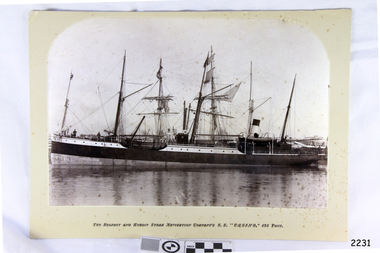 Flagstaff Hill Maritime Museum and Village
Photograph - Vessels, Sailing Ships, The Belfast and Koroit Steam Navigation Company's S.S. "Casino, 425 Ton, Late 19th to early 20th centuries
This black and white photograph shows the image of the coastal trading vessel S.S. Casino, with both sail masts and steam funnel. Men in hats are clearly visible on deck. The ship is in calm water and only light rigging is on the masts. Other vessels are in the background. Photograph is taken 1882-1932. The S.S. Casino was a passenger and freight steamer built in Dundee, Scotland, in 1882 for the Newcastle and Hunter River Steam Navigation Company of N.S.W. She weighed 425 tons gross with a length of 160.4 feet, beam of 24.1 feet and depth of 10.2 feet. She had saloon accommodation for 35 people, forecabin for 25 more people, and she carried 300 tons of cargo. While on her delivery journey on May 30th 1882 the S.S. Casino called in at the Port of Warrnambool for coal ., narrowly escaping going ashore in gale force winds due to the quick action of the pilot. At that time, still at anchor, she impressed the directors of the Belfast and Koroit Steam Navigation Company so much that they bought her immediately; she was ideal for trade in along the West Coast of Victoria. (Belfast is the original name for Port Fairy, South West Victoria. The Belfast and Koroit Steam Navigation Company was first managed by Messers. Saltau and Osburne and after the passing of Mr. Osburne, by produce merchants Messers H. Sautau and Sons, whose had a hay and corn store and shipping agency was on the corner of Liebig and Koroit Streets in Warrnambool. ) The S.S. Casino became “the most famous steamer to operate in Victorian waters along the West Coast” by author Jack Loney. Captain Boyd was her first Master, followed by Captain Chapman, who stayed with her 1890 until 1924. Captain W. Robertson followed for a short term, then Captain Middleton then took command 1925 - 1932. The S.S. Casino had several mishaps during her life. One was on 3rd January 1898 when she collided with the S.S. Flinders in Apollo Bay with minor damage. Another was on 24th October 1924 when she grounded on a reef at Point Hawdon near Grey River and most of her cargo (of Christmas goods) had to be dumped into the sea. Then in February 1929 she was ‘holed’ when she struck a submerged object as she entered Lady Bay, Warrnambool. On the morning of 10th July 1932, after attempting to berth at Apollo Bay jetty in heavy seas, Captain Middleton decided to take her out into the bay and wait until the seas abated. It was not realised that the anchor used to steady her as she manoeuvred to her berth had pierced her hull. She put about and headed for the beach but sank. Captain Middleton and nine others lost their lives; nine people were rescued including the two female passengers . Captain Middleton had been in charge of the S.S. Casino for seven years. He was the first ship’s Master to lose his life through shipwreck in the West Coast trade. In the years following the turn of the century the S.S. Casino remained the only regular trader with normal passenger accommodation along the West Coast. From 1882 she had made at least 2,500 voyages on the one run. Flagstaff Hill’s collection has a photograph of a portrait of Captain Chapman, , a ship model of the S.S. Casino that shows both forms of power under which she sailed, steam and sail. The ship is painted green and flies three flags. The inscription across the case of the ship model, incorrectly dated, tells the sad story of the wreck of the ship and the loss of lives on July 10th 1932 at Apollo Bay. A print in the Collection show S.S. Casino underway in heavy sea off Point Lonsdale, another two photographs show her at the Port of Warrnambool, leaving from the Breakwater in Lady Bay and another identifies the S.S. Casino as a ship from the Belfast and Koroit Steam Navigation Company. (Belfast is the original name for the township of Port Fairy). This photograph is significant because of its association with the coastal trader S.S. Casino and its significance to trade along Victoria's West Coast in the late 19th and early 20th century. It was taken 1882-1932 The wreck of the S.S. Casino is considered an important part of Victorian and Australian cultural heritage and as such has been declared and protected as an Historic Shipwreck under State and Commonwealth Law in the Commonwealth Historic Shipwrecks Act (1976). Photograph, black and white, taken 1882-1932. Foreground is vessel SS Casino, the Belfast and Koroit Steam Navigation Company's coastal trading ship. The ship, in calm water, has light rigging on its masts and also a steam funnel. One lifeboat is visible. People are on the deck. The background shows other vessels.Under the photograph "The Belfast and Koroit Steam Navigation Company's S.S. "Casino," 425 Tons"flagstaff hill, warrnambool, shipwrecked coast, flagstaff hill maritime museum, maritime museum, shipwreck coast, flagstaff hill maritime village, great ocean road, newcastle and hunter river steam navigation company, belfast and koroit steam navigation company, h. sautau and sons, s.s. casino, west coast trader s.s. casino, victorian coastal trader, captain boyd, captain w. robertson, captain chapman, captain middleton, apollo bay shipwreck, s.s. casino at lady bay warrnambool, saltau and osburne -
 Flagstaff Hill Maritime Museum and Village
Photograph - Portrait, about 1930
This photograph is of Angela Elizabeth Pearce, granddaughter of Tom Pearce - one of only 2 survivors from the shipwreck LOCH ARD. Angela Elizabeth Pearce had written in her grandfather’s Bible in childish handwriting the words “This Bible belongs to Angela E. Pearce”. Angela was born in England in 1925 and died in Woollahra N.S.W. in 1944, aged 19. She was one of Tom Pearce’s granddaughters. Her father, Robert Pearce was Tom’s second son. Tom Pearce is a famous hero, the rescuer of Eva Carmichael, the only other survivor from the 1878 shipwreck of the LOCH ARD. The Bible was given to Tom Pearce in recognition of his bravery at the wreck of the LOCH ARD. It is on loan to Flagstaff Hill Maritime Village from Parks Victoria. The ‘official’ inscription in the Bible reads, “Presented to Mr Thomas Pearce, In recognition of invaluable service performed in saving life when the Loch Ard was wrecked off the coast of Australia., by the Loyal Orange Institution of Victoria, Protestant Hall, Melbourne, August 1878” The photograph is accompanied by a letter, dated 4th May 2010, and is written by Angela’s cousin, Pamela Dormer of Devon, U.K. Her letter includes the words “Dear Mr Abbott, re Tom Pearce’s Bible, As you know, I have been in contact with Mr Peter Yarnis about means by which my grandfather’s presentation Bible can be released to be exhibited with his other effects, like the binoculars at Flagstaff Hill Museum. In the event that it will be, I have enclosed a photograph to join it. When my son Bill Dormer was at Port Campbell he was about to handle his great grandfather’s Bible and was surprised by a childish inscription opposite that of his presentation, which reads (I think this is the way it goes), THIS BIBLE IS THE PROPERTY OF ANGELA ELIZABETH PEARCE. Angela is my late cousin. Her father was Tom Pearce’s second son Robert Strasenburgh Pearce. I and my brother Raymond Simpson are the surviving grandchildren of Tom, by my mother Edith May Pearce, his only daughter. Angela and her mother, at the beginning of W.W.2, evacuated from England to Sydney, N.S.W. but sadly both were dead by early in the 60’s. Robert (my uncle Bobby) went down with his ship on the Malta Convoy, code named PEDESTAL, escorting with other ships the vital oil tanker OHIO to the island. (signed) Pamela Dormer” THE LOCH ARD’S STORY The sailing ship LOCH ARD was built in Glasgow in 1873 and belonged to the famous Loch Line. She made three trips to Australia and one trip to Calcutta before its final voyage which ended in tragedy near Port Campbell. The LOCH ARD left England on March 2, 1878, under the command of Captain Gibbs, a newly married, 29 year old. The ship carried a general cargo which reflected the affluence of Melbourne at the time. On board were straw hats, umbrella, perfumes, clay pipes, pianos, clocks, confectionary, linen and candles, as well as a heavier load of railway irons, cement, lead and copper. LOCH ARD also had a crew of 37, and 17 passengers. The voyage to Port Phillip was long but uneventful. At 3am on June 1, 1878, Captain Gibbs was expecting to see land and the passengers were becoming excited as they prepared to view their new homeland in the early morning. But LOCH ARD was running into a fog which greatly reduced visibility. Captain Gibbs was becoming anxious as there was no sign of land or the Cape Otway lighthouse. At 4am the fog lifted. A man aloft announced that he could see breakers. The sheer cliffs of Victoria's west coast came into view, and Captain Gibbs realised that the ship was much closer to them than expected. He ordered as much sail to be set as time would permit and then attempted to steer the boat out to sea. On coming head on into the wind, the ship lost momentum, the sails fell limp and LOCH ARD's bow swung back. Gibbs then ordered the anchors to be released in an attempt to hold its position. The anchors sank some 50 fathoms - but did not hold. By this time LOCH ARD was among the breakers, and the tall cliffs of Mutton Bird Island rose behind the ship. Just half a mile from the coast, the ship's bow was suddenly pulled around by the anchor. The captain tried to tack out to sea, but the ship struck a reef running out from Mutton Bird Island. Waves broke over the ship and the top deck was loosened from the hull. The masts and rigging came crashing down knocking passengers and crew overboard. It took time to free the lifeboats and when one was finally launched, it crashed into the side of LOCH ARD and capsized. Tom Pearce, who had launched the boat, managed to cling to its overturned hull and shelter beneath it. He drifted out to sea and then on the flood tide came into what is now known as LOCH ARD Gorge. He swam to shore, bruised and dazed and found a cave in which to shelter. Some of the crew stayed below deck to shelter from the falling rigging but drowned when the ship slipped off the reef into deeper water. Eva Carmichael had raced onto deck to find out what was happening only to be confronted by towering cliffs looming above the stricken ship. In all the chaos, Captain Gibbs grabbed Eva and said, "if you are saved Eva, let my dear wife know that I died like a sailor". That was the last Eva Carmichael saw of the captain. She was swept off the ship by a huge wave. Eva saw Tom Pearce on a small rocky beach and yelled to attract his attention. He dived in and swam to the exhausted woman and dragged her to shore. He took her to the cave and broke open a case of brandy which had washed up on the beach. He opened a bottle to revive the unconscious woman. A few hours later Tom scaled a cliff in search of help. He followed hoof prints and came by chance, upon two men from nearby Glenample Station three and a half miles away. In a state of exhaustion, he told the men of the tragedy. Tom returned to the gorge while the two men rode back to the station to get help. By the time they reached LOCH ARD Gorge, it was cold and dark. The two shipwreck survivors were taken to Glenample Station to recover. Eva stayed at the station for six weeks before returning to Ireland, this time by steamship. In Melbourne, Tom Pearce received a hero's welcome. He was presented with the first gold medal of the Royal Humane Society of Victoria and a £1000 cheque from the Victorian Government. Concerts were performed to honour the young man's bravery and to raise money for those who lost family in the LOCH ARD disaster. The media of the time had created one of Australia's first media celebrities. Everyone followed the story of Tom Pearce and Eva Carmichael with great interest and were disappointed when the two went their separate ways. It was felt by many that Tom should have proposed to Eva - given they had spent an evening together unsupervised in the cave and had drunk brandy to keep warm. Coleman Jacobs composed the music “The Young Hero Schottische” and dedicated it, by permission, to Mr. Thomas R. (Tom) Pearce. The sheet music was published in 1878 by the Messieurs Roberts, professors of dancing etc. Melbourne. It was on sale for 3/- (3 shillings) and in aid of the “LOCH ARD” fund. [This is Coleman Jacobs’ only surviving musical work Coleman Jacobs, accomplished pianist, musical performer, singer, composer, professor of music and music teacher, was born in 1827 and died on 4 July 1885, aged 58 years. Coleman Jacobs was buried in the Melbourne Cemetery (grave 461, Church of England section).] The wreck of LOCH ARD still lies at the base of Mutton Bird Island and much of the cargo has been salvaged. Some was washed up into what is now known as LOCH ARD Gorge following the shipwreck. Cargo and artefacts have also been illegally salvaged over many years before protective legislation was introduced. The photographic is of significance because of Tom Pearce and his association with the disaster of the LOCH ARD shipwreck, which is of State significance ― Victorian Heritage Register S417 Flagstaff Hill’s collection of artefacts from LOCH ARD is significant for being one of the largest collections of artefacts from this shipwreck in Victoria. It is significant for its association with the shipwreck, which is on the Victorian Heritage Register (VHR S417). The collection is significant because of the relationship between the objects, as together they have a high potential to interpret the story of the LOCH ARD. The LOCH ARD collection is archaeologically significant as the remains of a large international passenger and cargo ship. The LOCH ARD collection is historically significant for representing aspects of Victoria’s shipping history and its potential to interpret sub-theme 1.5 of Victoria’s Framework of Historical Themes (living with natural processes). The collection is also historically significant for its association with the LOCH ARD, which was one of the worst and best known shipwrecks in Victoria’s history. Photograph, sepia coloured, with accompanying letter. The photograph is a portrait of a young girl in a short sleeved top with a flower on her left shoulder. The girl is "Angela Elizabeth Pearce, granddaughter of Tom Pearce" as inscribed on back of photograph. Tom Pearce was one of two survivors of the 1878 shipwreck LOCH ARD. Included with the photograph is a letter from its donor, Pamela Joan Dormer, other granddaughter of Tom Pearce. The letter dated 4th May 2010 explains the connection between Angela Pearce and Tom Pearce's Bible.Back of photograph, written in blue pen “ANGELA ELIZABETH PEARCE / TOM PEARCE’S GRANDAUGHTER / PHOTO PRESENTED BY / HIS OTHER GRANDAUGHTER / PAMELA JOAN DORMER / 2010” Letter from Pamela Dormer verifying the connection between Angela Pearce and Tom Pearce’s Bible.flagstaff hill, warrnambool, shipwrecked coast, flagstaff hill maritime museum, maritime museum, shipwreck coast, flagstaff hill maritime village, great ocean road, angela pearce, tom pearce, thomas r pearce, eva carmichael, loch ard shipwreck, tom pearce bible, loch ard presentation bible, hero tom pearce, loyal orange institution of victoria, royal humane society of victoria, mutton bird island, coleman jacobs, the young hero schottische -
 Flagstaff Hill Maritime Museum and Village
Document - Plans, Lighthouse Keeper's Quarters Warrnambool, 1858-1909
The set of seven 1858 plans shows proposed plans for the original Lighthouse Complex that was built on Middle Island in 1858-1859. The whole complex was then transferred to Flagstaff Hill in 1871. The plan, dated 1909, is for proposed additions and repairs to the Quarters at Flagstaff Hill. The plan 'Alterations and Additions' shows alternate plans for changes to the quarters at the Flagstaff Hill location. This plan has no date. The Complex comprised the Lighthouse, the Lighthouse Keepers’ Quarters, the Store (now called the Chart Room) and a Privy, which was not included in these plans. The Keeper’s bluestone Quarters was a cottage divided into two compartments, one for each keeper and his family. The bluestone Store was divided into three; a store, a workshop an oil store (or office). The Privy comprised of a small building also divided into two separate, back-to-back toilets, one for each Keeper and his family. The Flagstaff Hill Keeper's Quarters have had extensions and additions at various times, and these have also been removed at various other times. THE PLANS - *Dec. 1858 (12/58) ‘Lighthouse Keepers Quarters No.2 Warrnambool’ (2375.01)* Public Works Office Melbourne – Front and Back elevations, sections, and floor plan. The drawing shows timber walls. [The floor plan is the closest plan to the current building, however, the walls are timber in this plan.] *Nov. 1858 – No.3 ‘Lighthouse Keepers Quarters Warrnambool’ (2375.02)* Office of Public Works, Melbourne – Back and End elevations and section through. The drawing shows stone walls. One side; Senior Keeper’s bedroom, living room and kitchen with storeroom. Another side; is the Assistant’s bedroom, living room and storeroom. *Nov. 1858 - No.4 ‘Lighthouse Stores Warrnambool’ (2375.03)* Office of Public Works – Front, Side and end elevations, centre section. The drawing shows stone walls. *Nov. 1858 – No.4, ‘Lighthouse Stores No. 2 Warrnambool’ (2375.04)* Office of Public Works – Front, side and end elevations, centre section. The drawing shows timber walls. *Nov. 1858 – ‘Details Lighthouse Keepers Quarters No. 2 Warrnambool’ (2375.05)* Public Works Office Melbourne. The plan shows the foundations, joists and eaves. The drawing shows timber walls. (Nov. 1858 – ‘No.4 ‘Lighthouse No. 2 – Warrnambool’ (2375.06)* Public Works Melbourne (Part of the paper is missing). This plan shows an octagonal tower, internal stairs, a balcony landing, and a weather vane on top. *November 1858 – No. 1, ‘Lighthouse – Warrnambool’ (2375.07)* Office of Public Works Melbourne. This plan shows a round tower, including the stairs, windows on the tower and the weather vane on the top. *4/3/9 [1909] – ‘Additions and Repairs, Lighthouse Quarters, Warrnambool, General Plan’ (2375.8)* Department of Public Works Melbourne’s official stamp is signed by Croft. It shows the floor plans of the Store, Upper Lighthouse and the Quarters. The Store building has three sections; a Store, Work-Shop and Office, with an internal wall between them and separate entries. The Quarters are divided into two dwellings. The Senior Keeper’s side on the left has fireplaces in two of the three bedrooms and there is a pantry and wash house. The Assistant’s side has no fireplaces in the bedrooms and there’s no pantry or washhouse. These plans include proposed changes to the buildings. The Senior Keeper’s Quarters would have a partition on bedroom 2, a bath with plumbing and drainage, a wall moved and a built-in side porch. The Store would also have a built-in porch. The undated plan 'Additions and Alterations' (2375.9) shows alternative arrangements for water tanks, plumbing and such. WARRNAMBOOL'S LADY BAY LIGHTHOUSES- In the 1800s ships sailing from England to Australia began to use Bass Strait as a faster route to Melbourne. Small navigation errors led to many tragic shipwrecks. From 1848 lighthouses were operating along Victoria’s southern coast as a guide for sailors. Coastal towns such as Warrnambool grew and the exchange of trade and passengers were of great benefit. However, the uncertain weather changes, relatively shallow waters and treacherous, hidden rocky reefs were not suitable for a Harbour and in the 1840s and 1850s there were many shipwrecks in the area, with some even stranded in its Lady Bay harbour. A jetty was built in 1850 and a flagstaff to guide seafarers was placed up high on what became known now as Flagstaff Hill. In November 1857 the Victorian Government recommended that Warrnambool Harbour had beacons and two lighthouses to guide vessels into and out of the Harbour safely. The white light of the Middle Island lighthouse was to be used for the first time on September 1, 1859. The red light of the Beach Lighthouse, a wooden obelisk structure, was first operated on March 25, 1860, but in 1868 this light was ‘discontinued’ due to it being too low. Melbourne’s Department of Public Works decided to relocate the Middle Island Lighthouse Complex - Lighthouse, Keeper’s Quarters, Privy, Store Room and even water tanks - to Flagstaff Hill. The lower obelisk was shortened, and a protruding gallery, railing, and external ladder were added, as well as the light from the Beach Lighthouse. A green guiding light was erected on the end of the jetty. The transfer of the Complex began in March 1871. Each shaped stone of the lighthouse was carefully numbered, removed then reassembled on Flagstaff Hill. In 1872 the well was sunk behind the Lighthouse Keeper’s Cottage. The Keepers and families had left Middle Island in April and moved to Flagstaff Hill in October 1871. Vessels entering Lady Bay align the Upper and Lower Lighthouse towers during the day and the lights at night. The Upper Lighthouse is a round tower, the Lower Light is square. The Lighthouses were categorised as harbour lights rather than coastal lights, so they remain under the control of the Victorian Government’s Ports and Harbours section. The lights were originally powered by oil, then acetylene gas, later by electricity, and then converted to solar power in 1988. In 1993 the solar panel was replaced by a battery charger. A decision was made in 1936 to replace the lighthouses’ lights with unattended lights that no longer required Keepers and Assistants. At least 29 Keepers had attended to the lighthouse from its opening in 1859 to when the last official Lightkeepers left In April 1916. The Warrnambool Harbour Board rented out the Quarters from 1916 to 1936. The Board closed down but the rentals continued with other unknown landlords. In the 1970s the Flagstaff Hill Planning Board was set up under the chairmanship of John Lindsay. The Board was to make recommendations to the Warrnambool City Council regarding the use of the buildings and the rest of the Crown Land on the site. The Flagstaff Hill Maritime Village opened in 1975 and began renovating the Cottage in stages, during which time evidence of a 1920s fire was found in the eastern section of the cottage. Additions of a porch on the west and a washroom on the east were made in the 1980s. The western part of the building is now a Shipwreck Museum and the east has returned to a late 19th-century Lighthouse Keeper’s cottage and includes the screen made by Assistant Lighthouse Keeper Thomas Hope during one of his two periods of service there. THE LIGHTHOUSE KEEPERS Lighthouse Keepers were responsible for keeping their Lighthouse’s lights shining at night. They kept a lookout for passing vessels and changes in weather. They were expected to clean, polish and maintain the equipment and buildings. They kept regular and detailed records of who was on watch, and the time the light was lit, trimmed and extinguished. They kept a journal about other events that occurred. They keep regular, accurate Meteorological Logs. It was expected that they were competent in Morse code signalling. They would be called to help in times of disasters and shipwrecks, and to give official statements about these events. Many Lighthouse Keepers also volunteered as members of the lifeboat crew. The Lady Bay lighthouses were officially classified as small, so the Keepers had the official titles of Senior Assistant Lighthouse Keeper and Assistant Lighthouse Keeper. They were employed by the Public Service and paid rent to live in the Lighthouse Quarters. They were compulsorily retired at the age of 60, with most receiving a superannuation payment. Despite their time-consuming duties, there was time to follow hobbies and crafts such as growing vegetables, playing musical instruments, making models of buildings including lighthouses, and crafting furniture pieces. An example of a keeper’s skills is the carved fire screen made by /assistant Keeper Thomas Hope in the early 20th century and displayed in the Lighthouse Keeper’s cottage at Flagstaff Hill. The last occupants of the Middle Island Complex were Senior Keeper Robert Deverell, his Assistant Keeper, Andrew Farncombe, and their families. They all became the first occupants at the Lady Bay Lighthouse Keepers’ Quarters on Merri Street. The Warrnambool Lighthouse Complex plans are the origin of what is now the Lady Bay Lighthouse Complex. They are a record of the people, process and departments involved in bringing the complex into fruition. The plans are significant to the Complex, which is now listed on the Victorian Heritage Register, H1520, for being of historical, scientific (technological) and architectural significance to the State of Victoria. The Complex is significant as an example of early colonial development. The plan are significant for their connection with the important navigational function of the Lighthouses, a function still being performed to this day. The plans are also significant as an example of a product from the Public Works Department in Victoria in the mid-to-late 19th century. The structures built to these plans still stand strong. Plans for the Lighthouse Complex in Warrnambool, including Lighthouses, Keeper's Quarters and Stores. Seven of the plans are on thin fragile paper, one is on thicker, stronger paper. The drawings have been made in pens coloured red and black. They originate from Public Works in Melbourne. Seven were drawn in 1858, one in 1904, the other is not dated.Dec. 1858 - Lighthouse Keepers Quarters No.2 Warrnambool. Public Works Office Melbourne. Nov. 1858 - No.3 ‘Lighthouse Keepers Quarters Warrnambool. Public Works Office Melbourne. Nov. 1858 - No.4 ‘Lighthouse Stores Warrnambool. Office of Public Works. Nov. 1858 - No.4, ‘Lighthouse Stores No. 2 Warrnambool. Office of Public Works. Nov. 1858 - Details Lighthouse Keepers Quarters No. 2 Warrnambool. Public Works Office Melbourne. Nov. 1858 - No.4 ‘Lighthouse No. 2 – Warrnambool. Public Works Melbourne. Nov. 1858 - No. 1, Lighthouse - Warrnambool. Office of Public Works Melbourne. 4/3/9 [1909] - Additions and Repairs, Lighthouse Quarters, Warrnambool, General Plan. Department of Public Works Melbourne. SIGNED "Croft" "15A" on reverse [no date] - Lighthouse Quarters Warrnambool, Additions and Alterations. "9A" on reverseflagstaff hill, warrnambool, lighthouse keeper's cottage, lighthouse residence, lighthouse, plans, public works, melbourne, flagstaff hill maritime museum, maritime museum, shipwreck coast, flagstaff hill maritime village, chart room, quarters, privy, middle island, beach lighthouse, obelisk, lighthouse keeper, assistant keeper, lighthouse complex, lady bay, lady bay complex, keepers, upper lighthouse, lower lighthouse, ports and harbours, cottage, harbour board, flagstaff hill planning board, meteorological record, robert deverell, andrew farncombe, warrnambool port, warrnambool harbour, residence, alterations, repairs, department of works