Showing 8527 items
matching snowy-river-dry-cleaners
-
 Kew Historical Society Inc
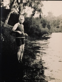
Photograph - Orlando Henry Beater Christian, 1860
An item from an outstanding and diverse photographic collection, assembled by members of the Christian and Washfold families of Kew.Small black and white photograph of the elderly Orlando Henry Beater Christian in a swim suit on the bank of the River Yarra. He appears to be holding a fishing line. orlando henry beater christian, river yarra, fishing -- yarra river -
 Melbourne's Living Museum of the West
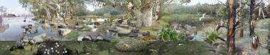
Exhibition, Melbourne's Living Museum of the West, Pobblebonk, 2005
10th panel (of 10) natural environment panoramic photo-montage about animals of the Maribyrnong River estuary. Portable display printed in colour on fabric, with stands. -
 Wodonga & District Historical Society Inc
Album - Hume Reservoir Australia Album - Quarry plant completed, September 1922
This set of photos is from a leather bound album bearing the inscription "HUME RESERVOIR AUSTRALIA" plus 'The Rt. Hon. L. C. M. S. Amery, P. C., M .P.' all inscribed in gold. It was presented to The Rt. Hon. L. C. M. S. Amery, P. C., M. P, Secretary of State for Dominion Affairs on the occasion of his visit to the Hume Reservoir on 2nd November 1927. This album is of local and national significance as it documents the planning and development of the Hume Reservoir up to 1927. It was the largest water reservoir in the British Empire. The album records the pioneering engineering work that went into its construction.DEPARTMENT OF PUBLIC WORKS, N.S.W. RIVER MURRAY WATERS SCHEME. HUME RESERVOIR. 10. Quarry Plant (New South Wales) completed. September 1922. hume reservoir australia, river murray waters scheme, quarry plant -
 Lakes Entrance Historical Society
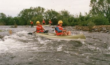
Photograph - Lakes Entrance Secondary School, Lakes Post Newspaper, 1993
Colour photograph students wearing life jackets and helmets, Secondary College, paddling canoes in small rapids on river, at school camp. Lakes Entrance Victoriaschools, activities -
 Lakes Entrance Historical Society
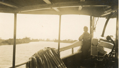
Photograph, 1930c
Sepia photograph taken from a boat on Mitchell River. Appears to be one of the ferries travelling between Bairnsdale and Lakes Entrance. Boy on bow of boat. Victoriawaterways, boats and boating, tourism, transport -
 University of Melbourne, Burnley Campus Archives
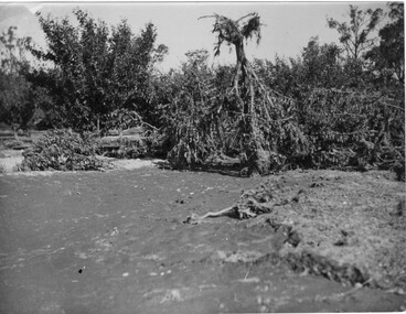
Photograph - Black and white print, A.P. Winzenried, Flood Damage, 1934
Appears as an illustration in, "Green Grows Our Garden," A.P. Winzenried p 66. On p. 66 of the text there is further information about the effects of the flood.Black and white photograph. Destruction caused in the Burnley orchards by the 1934 flood of the Yarra River. One large tree is upside down with its roots in the air.On reverse, "1934."orchard, green grows our garden, a.p. winzenried, flood damage, fruit trees -
 Lakes Entrance Historical Society
Photograph, Reg Schulz, 1938
Black and white photograph of shipping at Bairnsdale wharf, Mitchell River. Vessels unidentified, passenger vessel tied up, small shed on wharf. Bairnsdale Victoria jetties, ships and shipping -
 Linton and District Historical Society Inc
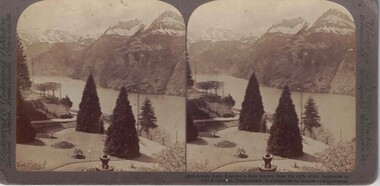
Stereograph, Underwood & Underwood, Publishers, Across Lake Lucerne's Deep Waters, Copyright 1902
One of two sets of stereographs donated by the O'Beirne family along with a stereoscope for viewing (Stereoscope is Registration no. 2014-51).Stereograph of two black and white images. Images are of a landscape. Trees, stairs, people in foreground. River through centre of image with snowcapped hill tops in background.1868 - Across Lake Lucerne's deep waters. from the cliffs of the Axenstein to / Uri Rothstock, Switzerland.stereographs -
 Lakes Entrance Historical Society
Photograph, Lakes Post Newspaper, 1991
Black and white photograph of four members of Tambo River Improvement Trust. A Neil, Charles Hogan, Alan Sommerville Ian Bulmer Lakes Entrance Victoriawater resources -
 Lakes Entrance Historical Society
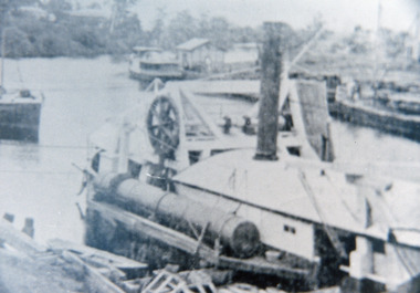
Photograph - silt jetties Eagle Point Victoria, 1957
Photograph taken with olde Brownie Box camera January 1957.Black and white photograph of Mitchell River silt jetties taken from cliff at Eagle Point Victoria. Second black and white photo of same areawaterways, jetties -
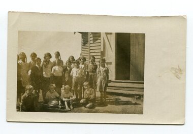 Orbost & District Historical Society
photograph, C1930s
In 1912 the school at Pumpkin Point opened to serve the children of farmers living in the Bete Bolong district. This meant a big change in their way of life because in the past the children had been rowed across the Snowy River each day to attend school at Jarrahmond. Myrtle Bunting was the first HT of the school which had been erected on a block of land purchased from H. Richardson. The school functioned until 1952 when a shortage of pupils caused its closure. As a bus service to Orbost now operated, the school at Pumpkin Point faced permanent closure. J. McKeown bought the building. Students attending the school at this time included Russells, Johnstones, Reeves, Healeys, Kavanaghs, Phillips, Rodwells, Mills, Baileys, Gilberts and Masons.These photographs are associated with the history of education in the Orbost district. There is no longer a school at Bete Bolong.Two small photographs of students standing at the doorway of a school building.photograph-bete-bolong-school eductation-orbost -
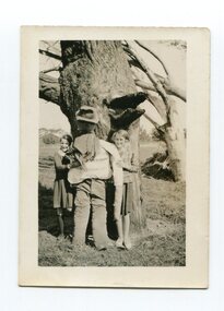 Orbost & District Historical Society
black and white photograph, 1936
In 1912 the school at Pumpkin Point opened to serve the children of farmers living in the Bete Bolong district. This meant a big change in their way of life because in the past the children had been rowed across the Snowy River each day to attend school at Jarrahmond. Myrtle Bunting was the first HT of the school which had been erected on a block of land purchased from H. Richardson. The school functioned until 1952 when a shortage of pupils caused its closure. As a bus service to Orbost now operated, the school at Pumpkin Point faced permanent closure. J. McKeown bought the building. Students attending the school at this time included Russells, Johnstones, Reeves, Healeys, Kavanaghs, Phillips, Rodwells, Mills, Baileys, Gilberts and Masons.This item is associated with the history of education in the Orbost district.A black / white photograph of two Bete Bolong State School pupils - girls - standing against a large tree trunk with a scarecrow between them.on back - handwritten " Hilda Russell & Elsie Morrison on Guy Gawkes at Bete Bolong"education-orbost bete-bolong -
 Phillip Island Conservation Society Inc.
Work on paper - Photocopy of newspaper cutting, "PHILLIP ISLAND/A place to fall in love"
This article was written by an English visitor named Elsa Christian who was touring Australia and New Zealand with her husband Frank in their own small van. The article was published in the Australian Women’s Weekly, magazine, March 1966. Elsa writes she wanted to visit four Australian locations before she died: Ayers Rock (actually Uluru), the Snowy River project, dolphins at Coolangatta and the Penguin Parade at Phillip Island. These destinations were all very popular in the 1960s for both Australian residents and overseas visitors. Because the roads were becoming better too many locations, self guided tours in small vans for cars towing bond would caravans were becoming more popular means of seeing AustraliaThe article is significant in many ways. 1. Indicates the places English visitors commonly wish to see in Australia. 2. Describes the growing trend to self- drive van/camping holidays. 3. Gives the route taken from Melbourne to Phillip Island during the 1960s. 4. Describes the appearance of the roadsides and locations visited. 5. It is written in a descriptive and lyrical style designed to appeal to Women’s Weekly magazine readers, who were probably wondering how they could visit Phillip Island with their husbands or families themselves, and what there was to see there. 6. Gives the visitors’ view of how the Penguin Parade operated at the time. 7. Includes a description of potter and artist Eric Juckert’s renowned garden at Grossard Point, Ventnor. 8. Indicates how introduced plants such as Hawthorn pushes and Kate weed were common in the area. 9. Describes Phillip Island as “a place to fall in love” because of its natural beauty, fauna and coastal seascapes. 10. As a visitor Elsa describes the housing estates as a blot on the landscape, but also sees the value as a way of their owners escaping from the hustle and bustle of Melbourne. 11. Gives the visitors’ interpretation of the behaviour of wildlife the RC in the wild, as well as Elsa’s knowledge about some of the species she encounters.Photocopy of full page article with 5 columns of text, a map and 2 photographs. Black ink on white paper. Photographs blackened in photocopying processphillip island, cape woolamai, penguin parade, seal rocks, nobbies, township of rhyll phillip island, princes highway, dandenong, pakenham, kooweerup, carinya creek, officer, san remo, gippsland highway, holiday homes, fort dumaresq, kitty miller's beach, wreck of the speke, hereford cattle, fleetwood manor, koalas, ventnor, eric juckert, little penguin behaviour -
 Eltham District Historical Society Inc
Negative - Photograph, The Leader, An Old-Timer and his Old-Time Blower, 2 Nov. 1929
Queenstown (St. Andrews) District. A gold miner with his home made dry blower device used for extracting gold particles from dry soil with out the use of water. In 1929, St Andrews was known as Queenstown. Originally published in The Leader, Nov. 2nd, 1929, with the title "Relics of the Old Mining days in the Queenstown District," a series of eight numbered photographs. 'The Leader'; a weekly journal of news, politics, agriculture, literature, science and sport.This photo forms part of a collection of photographs gathered by the Shire of Eltham for their centenary project book,"Pioneers and Painters: 100 years of the Shire of Eltham" by Alan Marshall (1971). The collection of over 500 images is held in partnership between Eltham District Historical Society and Yarra Plenty Regional Library (Eltham Library) and is now formally known as 'The Shire of Eltham Pioneers Photograph Collection.' It is significant in being the first community sourced collection representing the places and people of the Shire's first one hundred years.Digital image 4 x 5 inch B&W Neg Print 11 x 24.5 cmsepp, shire of eltham pioneers photograph collection, queenstown, gold mining, gold miner, st. andrews, old timer -
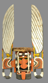 Burrinja Cultural Centre
Wanis Carved Wooden Mask, 1990s
Wooden mask carved from log with small hollow at back. Decorated in ochre, yellow, black and white pigment with shells for eyes. Tongue extends from mouth and white tusks stretch between the mouth and the top of the head. Dried plant material covers the top of the head. -
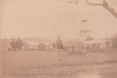 Learmonth and District Historical Society Inc.
Photo, "Willow Vale" Waubra, Victoria, Late 19th Century or Early 20th Century
It show the farm "Willow Vale" Waubra that was once owned by the Christopher and Selina (nee Smith) Harrison family who once lived on this farm and whoes descendants continue to live in the same area today.A very pale sepia photo of the "Willow Vale" farm at Waubra, Victoria that was owned by Christopher and Selina (nee Smith) Harrison. It shows a horse and buggy, along with the main house/houses and out buildings with what look like it could be a slightly dry dam at the bottom of the photo.Nil -
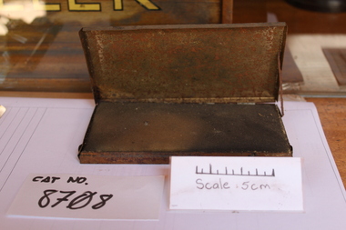 Coal Creek Community Park & Museum
Ink pad and case
8708.1 - The tin that holds the ink pad is very rusted and is stuck open. It has been painted white and black on the lid. 8708.2 - The ink pad is a very firm foam with a cloth over it. It has black dried ink in it with a patch where it has been sun damaged.8708.1 - Acme - Self Inking - Stamp Pad -
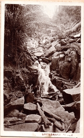 Southern Sherbrooke Historical Society Inc.
Photograph, Sherbrooke Falls
Photo of the falls in Sherbrooke Forest. Huge amount of large rocks in and around creek bed. Ferns grow up sides of banks. Low volume of water indicates dry season. At the top of the falls a man sits with another person who appears to be a woman. c.1920. -
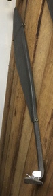 Mont De Lancey
Tool - Hay Knife, James Griffin & Sons, Unknown
A large steel curved bladed silage or hay knife with a tapered handle and a bent pointed sharp end. It was used to cut hay when it is dry. Blocks were cut for the ? or stack as needed for stock feed. Silage is an animal feed cut and stored while still green.agricultutal tools, hay knife, agricultural equipment -
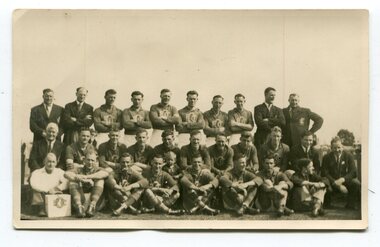 Orbost & District Historical Society
black and white photograph, 1954
The Orbost Football Club began in 1894. This photograph shows the 1954 team. The Orbost football club players were known as the Busters and wore green and gold guernseys. An Orbost football team has participated in the East Gippsland League since the early 20th century. The East Gippsland Football League in its present incarnation began in 1974 with the merger of the Gippsland Football League and the Bairnsdale District Football League .In 2003 in response to a dwindling population, the Snowy Rovers and Orbost Football Clubs were driven to merge into the Orbost Snowy Rovers Football clubs, through their many changes, have always been an important social fabric of the community. Sport is often regarded as an important part of life in rural Australia, contributing to community identity, sense of place, social interaction and good health.A black / white photograph of three rows of men wearing sports uniforms (players) and seven men in suits (officials). The fornt row is seated on the ground, the middle row on seats and the back row is standing with arms folded. a man in front row left has a case / box with the club emblem facing the camera. on back - a typed list of names and history of formation of League.sport-football orbost-football-club recreation clubs-orbost -
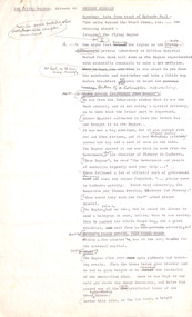
 Ballarat Tramway Museum
Document - Ballarat Tramways - Training notes - Preliminary Draft, State Electricity Commission of Victoria (SECV), Sept. 1947
Set of draft notes or points for the training of motormen. Covers tramcar electrical equipment, defects, cutting out motors, tramcar braking, failure of brakes, emergency braking, automatic braking (dead man controls), electric signals, general instructions running in trams, tram stops, preparing trams, derailments and track cleaner tram. Dated 29/9/1947, has initials "AVM:VM"Yields information and demonstrates a set of draft training notes for tram motormen in Ballarat.Twenty foolscap typed sheets and one handwritten quarto sheet.secv, ballarat, trams, tramways, sec, tramcar equipment, motors, employees, training, motormen -
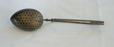 Orbost & District Historical Society
tea infuser, first half 20th century?
A tea infuser is a device in which loose, dried tea leaves are placed for steeping or brewing. The tea infuser gained popularity in the first half of the 19th century. This item is an example of a commonly used kitchen utensil not in common use today. It has been superseded by the teabag.A tea infuser spoon which looks like a small covered spoon. It is made from metal (brass?) with small holes. It has a narrow tapered handle.tea-infuser beverages kitchenware -
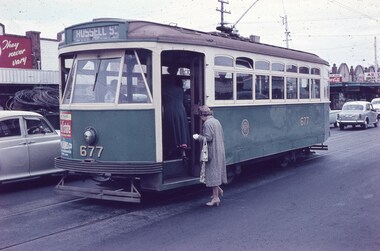 Melbourne Tram Museum
Slide - Set of 7, Keith Caldwell, 10/03/1960 12:00:00 AM
Set of 7 Agfa Colour slide, cardboard mount, by Keith Caldwell of 10 March 1960 - .1 - X2 677 - at the Williamstown Road terminus of the Footscray tram system. Tram photographed in Somerville Road, showing the return destination of Russell St. In the background are a row of shops. .2 - X1 460 turning from Leeds St into Barkly St. Tram has the destination of Ballarat Road. In the background is the bus stop and tram stop and the Trocadero Theatre side wall. See Image i6 for the Theatre. Has a Gant Motors advert. .3 - X1 467 out bound turning into Nicholson St from Irving St. Footscray with the Rockmans Store in the background. This store was later demolished for the Ring Road. Tram has adverts for Gant Motors and Swing Bridge Motors - Holdens. .4 - X1 460 turning from Barkly St into Leeds St, showing the destination of Ballarat Road. Has adverts for Calders watches and Coca Cola - drive safely. In the background is a cafe advertising Oysters, Grey Cigarettes and Vincents Powders. .5 - X1 464 turnings from Nicholson St into Irving St. Footscray with the Rockmans Store in the background. This store was later demolished for the Ring Road. Also is J. Boltons Chemist shop advertising Kodak film and another shop - ? dry cleaners, Footscray Fish Shop and Kings Hotel. Tram has adverts for Gant Motors and Doods Dry cleaning. There is a PMG truck parked outside Rockmans. .6 - X2 677 turning from Barkly St into Leeds St with the Trocadero Theatre in the background. Tram has the destination of Williamstown Road. Tram has an advert for Bridge and Webster. .7 - X1 467 outbound to Williamstown Road, turning from Leeds St into Irving St Footscray. Tram has adverts for Doods dry cleaning and Gant Motors.All hand stamped "10 Mar '60". .1 - marked "Footscray" .2 - "Footscray (NB curves)" .3 - to .7 "Footscray"trams, tramways, footscray, x2 class, russell st, williamstown rd, leeds st, ballarat rd, barkly st, nicholson st, irving st, tram 677, tram 460, tram 467, tram 464 -
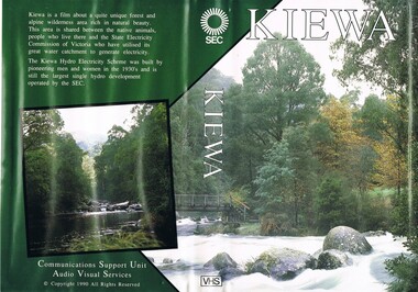 Kiewa Valley Historical Society
VHS Tape - Kiewa Hydro Electricity Scheme x2, Kiewa, Circa 1990
This VHS was produced by the State Electricity Commission of Victoria, to show the pristine state of the Kiewa River and Valley post the completion of the Kiewa Hydro Electricity Scheme (Circa 1950s), The late 1970s on wards was the beginning of deeper social scrutineering by pro environmental groups such as the Australian Wilderness Society (1976) and the Greens (political Party), before, during and after the construction phases of any man made structures in forest/bush areas which may or could damage or adversely affect the natural flora and fauna of sites. This promotional VHS, which was produced in the 1990s, was to project that unlike the Tasmanian State Electricity Commission (Franklin Dam issue), the Victorian State Electricity Commission acted in a way to protect the environment to the maximum level possible. With the passage of time since, and the issue of the global push to minimise carbon pollution, and as an alternative to coal fired power stations, the use of hydro electricity can now be seen as a highly efficient alternative to "coal powered" electricity. This VHS is a snap shot in time (1990) when the Kiewa Valley was still relatively under populated and holiday houses owned by city bound workers was still relatively insignificant. As more and more holiday makers retire to a small but friendly region(Kiewa Valley and Mount Beauty) the increase in visitor numbers will affect the local rural bush scene more and more. The changes that will occur (in time) can be measured against the scenes presented in this video. The additional resources provided by the State Electricity Commission of Victoria of "alpine bush" fire control and management, together with an ongoing educational scheme for school children in learning about what constitutes the Alpine country's unique environment, are a very important offshoot, benefitting to both the communities within the Kiewa Valley and regional Victoria.This VHS tape is stored within its own plastic cover which has a front side covered by a coloured photograph(both front and back cover) of the Kiewa River, just to the north east of the Mount Beauty township. The VHS tape is nestled within a formed inner structure which not only prevents the tape from moving to and fro but also unnecessary intrusion of foreign particles.Front cover "KIEWA" on the spine top circle with lines projecting out and below this "SEC". Middle of spine "KIEWA" and bottom of spine "VHS"secv, kiewa valley, dale-bromley, cy-duff, chris- harding, michael-glucz, forestation education, wilderness photography, nature film. -
 Robin Boyd Foundation
Document - Script, Robin Boyd, The Flying Dogtor. Episode 44 Mystery Mission, 1963
The Flying Dogtor was called to Canberra by Sir Thomas Persian, the Minister of Fishery, to help with a serious problem at the Snowy Mountains. The mighty hydro-electric scheme there was being invaded by a monster. This, the Minister explained to The Flying Dogtor.The Flying Dogtor" series was broadcast on Australian Television Network (later becoming the Seven Network) between February and April 1964 (see item D254 for schedule).Typewritten, foolscap, 2 pagesMultiple handwritten pencil edits and additions.the flying dogtor, robin boyd, crawford productions, manuscript -
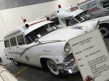 Ambulance Victoria Museum
Vehicle, motor, Ambulance, Ford Mainline, 1957, 1957
This vehicle was owned and operated by Rural Ambulance Victoria. It was first used by the Snowy Mountain Hydro-Electric Authority as an ambulance, and was stationed at Adaminaby. It was later transferred for use by the North Eastern Regional Ambulance Service (1977)Four-wheeled vehicle fitted out as an ambulance. Bodywork painted white with chrome trim. Red light located on roof. The word "Ambulance' painted in red above the front windscreen.Registration number 148164 .ambulance, motor vehicle, ford, ford mainline 1957, rural ambulance victoria, snowy mountain hydro-electric authority, adaminaby -
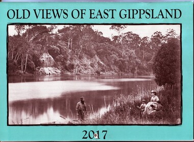 Orbost & District Historical Society
calendar, E-Gee Printers, Old Views of East Gippsland 2017, 2016
This is one of a series of calendars compiled annually by East Gippsland Historical Society.This is a useful pictorial reference tool.A 2017 stapled calendar, titled "Old Views of East Gippsland". On the turquoise coloured front is a black/white photograph of Eagle Point, Mitchell River C 1875 with a family group, possibly Alfred Howitt and children, on the bank of the Mitchell River opposite Eagle Point Bluff.. It contains early photographs of East Gippsland,. There is a hole for hanging. The title is at the top and the year at the bottom in black print. calendar-old-views-of-east-gippsland photographs-historic-east-gippsland -
 Yarra Glen & District Historical Society
Sepia postcards, Yarra Glen
Sepia postcard with a view taken from the Grand Hotel tower looking down on Bell Street and the railway crossing at Yarra Glen very late 19th century. Young street trees on Bell Street. On east side of Bell Street are a dwelling, a general store, the Victoria Hall, a horse trough. Beyond the railway line is 'River View', the bridge over the river and the Yering flats.On back of postcard at the top "POST CARD". On the left hand side "THIS SPACE MAY BE USED FOR PRINTED OR WRITTEN MATTER”. On the right hand side "ONLY THE ADDRESS TO BE WRITTEN HERE”. In a box in the right hand corner "A HALF-PENNY STAMP TO BE PLACED HERE". Along the left hand margin "Ajax series. Printed in England". In blue biro is written "G. Keets Yarra Glen". Copy 2 has the following handwritten in black ink: "Yarra Glen. 28.8.11. Dear Maggie Hope you will like the Postcard. I also hope your head is better. On Saturday we took the kitten down to Dawborn's shop to catch some mice. When we got down there the kitten got away from us and we never got it till Monday morning. This is all the news this time. From your loving cousin, Walter.yarra glen, railway line, grand hotel, victoria hall, bell street, tree guards, railway crossing, river view, street trees, bell st, general store, horse trough -
Bendigo Historical Society Inc.
Map - REDESDALE : COUNTY OF BENDIGO, 24-12-24
Map. Redesdale, County of Bendigo, County of Dalhousie, Kimbolton, Langwornor, Spring Plains, Glenhope, Emberton, Metcalfe, Hawkestone, County of Talbot, Campaspe River, Back Creek, River Coliban, Lyell. By authority H.J. Green, Government Printer, Melbourne. Photo-Lithographed at the Department of Lands and Survey, Melbourne by W.J. Butson, 24-12-24, Price 1/-. (number 120 in map cupboard 1)H.J. Green, Government Printer, Melbourne.map, bendigo, redesdale -
 Sunshine and District Historical Society Incorporated
Photographs (1928), 'QUARTER MILE' BRIDGE Construction, 1928
One man lost his life during the building of this bridge. The bridge was constructed by the Victorian Railways between 1927 to 1929 to carry a new double track goods line. This enabled trains from all parts of the state except Gippsland to have direct access to the Tottenham marshalling and sorting yards. These yards were constructed in the 1920's to relieve congestion in the Melbourne Yard near Spencer Street station. The congestion was being caused by the construction of suburban passenger platforms associated with the electrification of the suburban railway network. Initially the bridge was for goods trains but during the Second World War it was also used by troop trains. When the standard gauge line was built in 1962 all trains to Albury and Sydney have used this route, thus avoiding travelling through Essendon and Pascoe Vale on the suburban tracks. The standard gauge track across the bridge took the place of one of the broad gauge tracks so broad gauge trains crossing the bridge in either direction have to now use the same track. The bridge is 1,257 feet (383.13 metres) long and 180 feet (54.86 metres) above the water level. It is just 63 feet (19.2 metres) short of a quarter mile in length between abutments. There is a similar bridge on the same railway line crossing the Moonee Ponds Creek between Gowenbrae and Glenroy, however it is smaller at 1060 feet (323.08 metres) length and 115 feet (35.05) height.The bridge is now Victorian Heritage Registered under Number: H1197, and Heritage Overlay Numbers HO5, and HO107. On the Heritage Register it is named RAIL BRIDGE (ALBION VIADUCT). According to the Heritage Report the bridge is scientifically and architecturally important because of its large size, and because of the cost effective design features such as two girders per span (one for each track), the K bracing in the towers, and the broad flange beams as columns. When it was being built it was the largest trestle bridge in Australia, and until the Sydney Harbour bridge was constructed it was the highest railway bridge.Five B&W yellowing photos showing stages of construction of the Maribyrnong River Viaduct known as the Trestle Bridge but mainly known locally as the QUARTER MILE BRIDGE. It is a railway only bridge which runs over the Maribyrnong River between Sunshine North and Keilor East. A sixth image, which is not part of this set of photos, is included to show what the completed bridge looks like.