Showing 10966 items matching " plan."
-
 Bendigo Historical Society Inc.
Document - LYDIA CHANCELLOR COLLECTION. 'BENDIGO'S COMMUNITY SERVICES' - A STUDENT VIEW
Document. A 66-page report of the Bendigo Regional Welfare Planning and Co-ordinating Committee. Contains various authors. Topics included - social planning, employment, health, housing, legal services, local government welfare services, tourism, transport, and voluntary organizations. August 1975.Lydia Chancellororganization, society, community services -
 Ringwood and District Historical Society
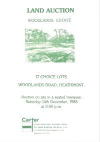
Pamphlet - Land Sales Brochure, Woodlands Estate, Heathmont, 1985
Bifold pamphlet with picture on front, one inside plus plan of Woodlands Road sub division and locality plan on back page. All in green print. Copy enclosed with handwritten sale prices. Auctioneer's notes (Richard Carter) indicate vendor - Estate of Phoebe Beard.Auction on site in a seated marquee, Saturday 14th December, 1985. Agent - C.E. Carter & Son Pty. Ltd., 122 Whitehorse Road, Ringwood, 3134. Telephone 870 6211. -
 Bendigo Historical Society Inc.
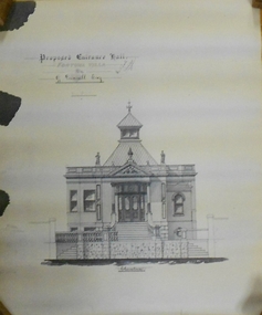
Document - MARKS COLLECTION: PLAN OF FORTUNA VILLA ENTRANCE HALL
Copy of plan: Written on top: Proposed Entrance Hall, Fortuna Villa, for G. Lansell, Esq. Plan shows section of building, central staircase leading to front doors, double doors with side panels. Turret, with skylights on top. Signed on top: 'W. Beebe, Architect'.buildings, house, fortuna villa -
 Bendigo Historical Society Inc.
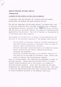
Document - BENDIGO HERITAGE ADVISORY SERVICE: REPORT TO COUNCIL, JAN 1987
Bendigo Heritage Advisory Service - Report to Council, Jan 1987, This appears to be a draft report as there are handwritten changes on a number of pages. Report is set out in the form of an Introduction and a Summary. Advisory Service comprised Heritage Advisor, Andrew Ward; Bendigo and Eaglehawk Councils; National Trust; Bendigo Historical Society; MPE and Historic Buildings Council; community representatives??; City of Bendigo - Cr Rod Fyffe, Mr Norm Cameron. Recommendations - Changes to Planning Scheme; Policy encouraging reuse of Buildings; Adoption of Action Plans; Council to encourage Heritage based Tourism; Appropriate development applications encouraged. Attached are seven short papers on specific aspects of heritage planning - 1. a Statement of Bendigo's Significance; 2. The economic importance of heritage planning; 3. Planning Scheme heritage provisions; 4. Procedures for permits; 5. Action plans for Bendigo precincts; 6. Reuse of buildings; 7. Government incentives for heritage conservation., (this last one not attached as ''Already Circulated''.Bendigo Heritage Advisory Servicebendigo, council, heritage advisory committee, bendigo and eaglehawk councils. national trust, bendigo historical society, historic building council. reuse of buildings. -
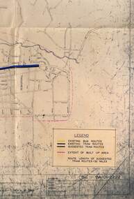 Ballarat Tramway Museum
Map - Map/s, State Electricity Commission of Victoria (SECV), Ballarat bus routes, 1971
Set of five maps prepared by the SEC/Transport Regulation Board? reviewing the option for Ballarat bus routes after the closure of the Ballarat tramway system. Based on SEC drawing No. BA-D1-2222, drawn at 1" = 20 chains. Shows streets in Ballarat and Sebastopol areas. 1775.1 - tram lines shown in heavy blue lines, with grey and yellow (actual operating bus routes at the time?) routes marked out. A red dashed line defines the general built up area. 1775.2 - "PLAN A" - shows various routes in different colours for Davis, Sproule, Hick ex Whkes, Lyons, Braybrooks and Witkins services and existing tram lines. 1775.3 - "Plan B" 1775.4 - "Plan C" 1775.5 - "Plan D" 1175.6 - Plan as above, but showing existing bus routes, tram routes and suggested tram routes. Has a small sheet of paper that was clipped to the drawing. Not dated. Not known exactly the basis that these plans were drawn up on. Drawings to be scanned.trams, tramways, closure, bus routes, tram replacement, sec, transport regulation board, ballarat, tram routes -
 Ringwood and District Historical Society
Newspaper, Scrapbook Clipping, Library Collection, Ringwood, Victoria
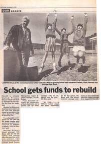
Newspaper Clipping from "The Mail", 16-11-1993. P 31 Our peoplePlans to rebuild Mullum Primary School which was badly damaged by fire earlier this year are under way. The Minster for Education, Don Hayward confirmed lasty week that $200,000 would be provided to the school during the 1993-1994 financial year. The Principal, Rob Bloye, said he was delighted with the concept plans discussed last week with architect John Brand. -
 Federation University Historical Collection
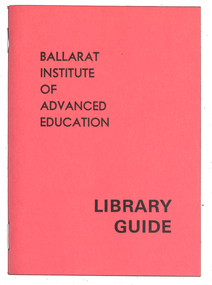
Booklet, Waller & Chester, Ballarat Institute of Advanced Education and Ballarat College of Advanced Education Library Guides, c1975-1978
Ballarat Institute of Advanced Education and Ballarat College of Advanced Education is a predecessor institution of Federation University Australia. The small library guides published to assist users of the Mt Helen Library. .1) Yellow covered booklet of 31 pages, including Ballarat College of Advanced Education library plans and, photographs, c1976. .2) Salmon covered booklet of 31 pages, including Ballarat Institute of Advanced Education library plans and, photographs, c1975 .3) Green covered booklet of 31 pages, including Ballarat College of Advanced Education library plans and, photographs, c1978.mt helen library, e.j. barker library, ballarat college of advanced education, library, librarians, law collection, audio-visual collection, catalogues, card catalogue, loans, reciprocal borrowing, counter reserve, ballarat institute of advanced education, dewey classifications, fines, periodical collection, examination papers, conversation rooms -
 Bendigo Historical Society Inc.
Document - MCCOLL, RANKIN AND STANISTREET COLLECTION: MONUMENT HILL CONSOL. BATTERY SITES & WATER RIGHT LICENCE
Documents: Manilla folder - licences to treat tailings with various plans and notes attached. Various notes - tailings licences Central Nell Gwynne and Monument Hill. Plans for areas applied for on leases 10852, 10166,10423,10238. Plans - area applied for tailings licence applications for leases/water right licences. Prospectus Nell Gwynne(BML) Mines N/L. Various notes relating to above Monument Hill Consol. Battery sites and water right licence.MCCOLL RANKIN & STANISTREETbusiness, gold mining, mccoll rankin & stanistreet, monument hill gold mine, battery, water right -
 Melbourne Tram Museum
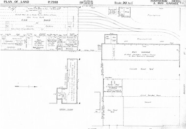
Drawing, Melbourne & Metropolitan Tramways Board (MMTB), "Footscray Depot and bus garage", c1937
Set of three photocopied plans or drawings on A3 sheet of "Footscray Depot and bus garage" c 1937 .1 - P7993 - Plan of land showing car shed, bus garage and offices dated 1-4-1937 - shows substation location. .2 - P? - Plan of land showing buildings and surrounding properties - dated 1-4-1937 .3 - P79821 - ditto but a wider area - dated 1-4-1937 - shows substation location.trams, tramways, drawings, depots, property, footscray depot, substation -
 Melbourne Tram Museum
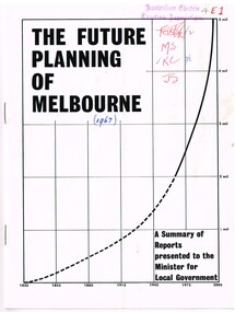
Document - Report, Commerce News, "The Future Planning of Melbourne - A summary of Reports - Minister for Local Government", 1967
Printed report or paper, 16 pages on gloss paper, centre stapled titled "The Future Planning of Melbourne - A summary of Reports presented to the Minister for Local Government" looking at the growth of Melbourne, water supply, metropolitan boundaries, 1966-67. Includes submissions from Town and Country Planning Association, MMBW, Regional planning, decentralisation, finance, commuter services. Process created by Rupert Hamer, the Local Government Minister at the time. Published as a supplement to "January Commerce News.""4E1" in ink on front cover, AETA stamp, the date "(1967)" and peoples initials on the front cover.trams, tramways, melbourne, victoria, development -
 University of Melbourne, Burnley Campus Archives
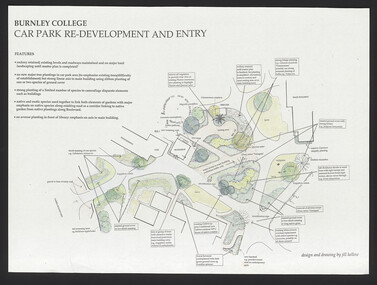
Plan, Burnley College Car Park Re-development and Entry, 1993-1998
(1) Coloured plan, Concepts for discussion by Phil Tulk 27.11.97. (2) As above dated 15.5.98. (3) Coloured rough plan. (4) 1 tracing paper, 1 coloured paper copy and 2 copies, Burnley College Car Park Re-development and Entry by Jill Kellow. (5) Notes for discussion. (6) Site Plan VCAH Carpark Landscape Graphics Assignment No 1 by Ken Wallace, March 1993. Scale 1:100.jill kellow, phil tulk, ken wallace, vcah, car park, rockery, main entrance -
 Bendigo Historical Society Inc.
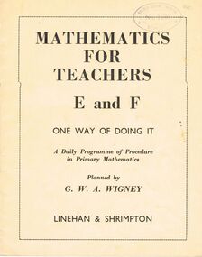
Book - GOLDEN SQUARE LAUREL STREET P.S. COLLECTION: MATHEMATICS FOR TEACHERS
Two copies of Mathematics for Teachers, Covering Sections E and F, One Way of Doing It, planned by G.W.A.Wigney. Books have cream coloured covers with black printing. Book contains plans for lessons. 8800.17d bears what may be a signature that looks very like the surname Gotch.By G.W.A. Wigney, Registered at G.P.O Melbourne for transmission through the post as a book. Wholly set up and printed in Australia by Renown Press Pty Ltd., 16-20 Woorayl Street, Carnegie.education, primary, golden square laurel st p.s., golden square laurel street p.s. collection - mathematics for teachers e and f, g w a wigney, linehan & shrimpton, renown press pty ltd, education department -
 Bendigo Historical Society Inc.
Map - CAMPBELL COLLECTION: BENDIGO AND DISTRICT MAPS, 18-6 29
Map. Longlea, Parishes of Axedale and Eppalock, scale 20 chains to 1 inch, total area 2372 acres. Prepared from Assessment Plan and Parish Plan by H.A. Darby18-6-29., Wondong, Heathcote and Sandhurst line (Railway). (number 386 in map cupboard 1)H.A.Darbymap, bendigo, agricultural lands -
Port Melbourne Historical & Preservation Society
Document - Submissions, Barak Road and Beacon Road developments, 1972
22 stapled pages regarding Barak & Beacon Roads development. Submissions to Minister of Lands from Cr TURNER and Cr JULIER 1972. MMBW planning map. Fishermens Bend Productivity Group working committee notes. Drawings and plans for housing, notes on developments 1955 -1972built environment - public housing, built environment - domestic, local government - city of port melbourne, leslie stanley turner, raymond frank julier, perce mcguire white, perce white, w a borthwick -
 Whitehorse Historical Society Inc.
Document, Blackburn, 1/08/1995 12:00:00 AM
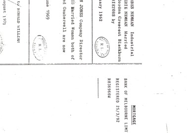
py of Certificate of Title Vol 8380 Fol 661, Lot 1 on Plan of Subdivision No 56619 fronting on Gordon Crescent near Central Road,Photocopy of Certificate of Title Vol 8380 Fol 661, Lot 1 on Plan of Subdivision No 56619 fronting on Gordon Crescent near Central Road, Blackburn to Finlay Urquhart, 7 November 1962; with plans from Vol 6839 Fol 696 from which title is derived.py of Certificate of Title Vol 8380 Fol 661, Lot 1 on Plan of Subdivision No 56619 fronting on Gordon Crescent near Central Road,land subdivision, gordon crescent, blackburn, central road, urquhart, finlay, newman, jeffrey william forbes, valerie, jones, ian edward swanson, joan mary, strickland, kenneth william, wilma dawn -
 Bacchus Marsh & District Historical Society
Map, Gorrockburkchap Parish Map, County of Grant c.1906
The parish of Gorrockburkchap (sometimes spelled Gorrockburkghap) lies to the west and south west of the township of Bacchus Marsh. The locality of Rowsley is situated within this parish area.A single page paper map showing the parish plan for Gorrockburkchap in the County of Grant. A cadastral map showing parish boundaries and land ownership The map is pasted into a bound volume containing 76 maps or plans in total. High resolution digital image stored on BMDHS computer network. gorrockburkchap parish maps, rowsley victoria maps, bacchus marsh region parish plans -
 Bendigo Historical Society Inc.
Document - LANDS OFFICE: DISTRICT SURVEYORS SANDHURST INDEX OF PLANS, no date probably 19C
Document: dark green hard cover journal with buff spine and corners. Index in front A - Z. 400 pages, pages not indexed but numbered. Index lists places of various districts e.g. Bridgewater on page 7. Plan details give allotments, parish, sections, plan number.Lands Officelands office, index of plans, plans, bendigo -
Clunes Museum
Plan - TITLE PLAN, DEPARTMENT OF LANDS AND SURVEY, PARISH OF CLUNES - COUNTY OF TALBOT, 1959
.1 1 PAGE PLAN LISTING TITLES FOR THE PARISH OF CLUNES 1959 (3 COPIES) SHEET 1 SCALE: 1 INCH TO 40 CHAINS .2 1 PAGE PLAN LISTING TITLES FOR THE PARISH OF CLUNES 1959 SHEET 2 SCALE: 1 INCH TO 2 CHAINSBY AUTHORITY A C BROOKS GOVT. PRINTER, MELBOURNE PARISH OF CLUNESparish of clunes, title plans clunes -
 Kew Historical Society Inc
Plan - Subdivision Plan, Jas R Mathers Son & McMillan, The Dale Estate, Deepdene, 1918
Pru Sanderson, in her groundbreaking ‘City of Kew Urban Conservation Study : Volume 2 - Development History’ (1988), summarised the periods of urban development and subdivisions of land in Kew. The periods that she identified included 1845-1880, 1880-1893, 1893-1921, 1921-1933, 1933-1943, and Post-War Development. These periods were selected as they represented periods of rapid growth or decline in urban development. An obvious starting point for Sanderson’s groupings involved population growth and the associated economic cycles. These cycles also highlighted urban expansion onto land that was predominantly rural, although in other cases it represented the decline and breakup of large estates. A number of the plans in the Kew Historical Society’s collection can also be found in other collections, such as those of the State Library of Victoria and the Boroondara Library Service. A number are however unique to the collection.The Kew Historical Society collection includes almost 100 subdivision plans pertaining to suburbs of the City of Melbourne. Most of these are of Kew, Kew East or Studley Park, although a smaller number are plans of Camberwell, Deepdene, Balwyn and Hawthorn. It is believed that the majority of the plans were gifted to the Society by persons connected with the real estate firm - J. R. Mathers and McMillan, 136 Cotham Road, Kew. The Plans in the collection are rarely in pristine form, being working plans on which the agent would write notes and record lots sold and the prices of these. The subdivision plans are historically significant examples of the growth of urban Melbourne from the beginning of the 20th Century up until the 1980s. A number of the plans are double-sided and often include a photograph on the reverse. A number of the latter are by noted photographers such as J.E. Barnes.The Dale Estate in Deepdene was made possible by the death of Robert Sparrow Smythe, Australian journalist, newspaper editor/owner and theatrical manager. Smythe lived in his residence ‘Highate’, Deepdene until his death in 1917. In the subdivision proposed one year later, before the end of the First World War, 18 allotments were to be created. The very fragmentary plan in the Society’s collection notes that a large weatherboard [house] will need to be removed. This may be Smythe’s own home. The proposed subdivision included allotments facing Burke and Whitehorse Roads and Dale Street. Bordering the subdivision is the Deepdene Station and the Outer Circle Railway Line. The clear directions on the plan indicate that in 1918 it was possible to travel by train from Deepdene to East Camberwell and Ashburtonsubdivision plans - deepdene, the dale estate -
Federation University Historical Collection
Booklet - Report, Regional College Development Planning Paper, 1976
Ballarat School of Mine's 'Regional College Development Plan' for the Lydiard Street Campus. It includes minutes of meeting in 1976.ballarat school of mines, ballarat regional college, graham beanland, ballarat technical school, ballarat girls'high school, mount clear technical high school, tertiary orientation program, campus plan, smb campus plan -
 Phillip Island and District Historical Society Inc.
Newspaper clippings, 15/11/1938
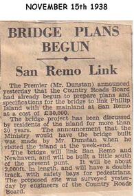
Newspaper articleArticle stating Country Roads Board had begun to prepare plans for the San Remo Phillip Island Bridge.local history, documents, newspapers, bridges, phillip island, black & white newspaper clipping, mr dunstan premier of victoria, country roads board -
 Phillip Island and District Historical Society Inc.
Newspaper Clipping, 7/11/1968
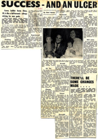
Article from a collection of newspaper clippings from October 1968 to July 1971Article about Kevin Shaw and his building success on Phillip Island and future plans for many projects on the island.phillip island, kevin shaw, builder -
Glenelg Shire Council Cultural Collection
Letter - Letter - Vanda Savill to Frances Hall, n.d
Two photocopies of a letter from Vanda Savill to Frances Hall, Historic Buildings Council, Department of Planning and Housing.historic buildings, heywood, vanda savill -
Glenelg Shire Council Cultural Collection
Flyer - Flyer - Maretimo, Portland Victoria, n.d
Foolscap size flyer, yellow, burgundy print. Information for visitors to 'Maretimo' Portland, including floor plan of building -
4th/19th Prince of Wales's Light Horse Regiment Unit History Room
Booklet, Arbuckle Waddell Pty Ltd, Operations Military Training Pamphlet No 23 Part 1 General Principles, Fighting Troops & Their Characteristics, 1939
Soft covered booklet, covering the principles of war, tactics, planning, command & control etc and the fighting troops and their characteristics. tactics, training, world war 2 -
4th/19th Prince of Wales's Light Horse Regiment Unit History Room
Booklet, Land/Air Warfare Pam 4 Airborne & Air Transported Operations 1953, 1953
A soft covered booklet as a guide to all Army and RAF officers on the planning or conduct of airborne operations. With amdt No 1WO Code No 8785airborne operations -
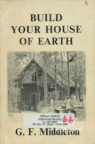 Eltham District Historical Society Inc
Book, George Frederick Middleton, Build your house of earth : a manual of earth wall construction / G.F. Middleton, 1979
"This book was "the bible" of mud brick and Pise builders in the 1950s"Paperback; xiii, 130 p., [8] p. of plates : ill. (some col.), diagrs., plans ; 25 cm.ISBN 0908136722 (pbk.)buildings, mudbrick, mud brick construction -
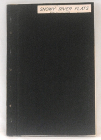 Orbost & District Historical Society
plans, 1966?
These survey plans are a useful research tool.A flat green fabric folder with a white label with "SNOWY RIVER FLATS" hand-written in black. It contains plans.plans-survey snowy-river-flats department-crown-lands-victoria -
Ringwood and District Historical Society
Plans - Building, Browning, George et al, Heathmont Pre-School architects plans. 1999, Feb-99
Photocopy of architects plans of Heathmont Pre-School Centre. +Additional Keywords: Secomb, Frank, F.R.A.I.A. / Ritchie, Alan -
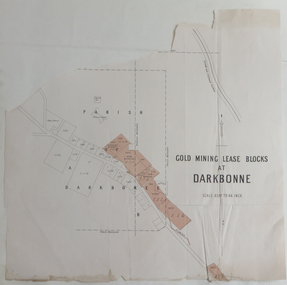 Federation University Historical Collection
Plan, Goldmining Lease Blocks at Darkbonne, c1887
This map was originally inserteed into the Reports of Mining Registrars for the Quarter ender 30th June 1887.Paper plan showing Goldmining Lease Blocks at Darkbonne, north west of and near St Arnaud, on the Sunraysia Highway. darkbonne, st arnaud, new bendigo mine, alpha mine, working miners mine, chinese camp, donald/st arnaud railway, saint arnaud, darkbonne state school