Showing 8535 items
matching snowy-river-dry-cleaners
-
 Yarra Glen & District Historical Society
Sepia postcards, Yarra Glen
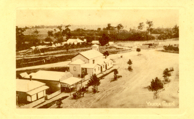
Sepia postcard with a view taken from the Grand Hotel tower looking down on Bell Street and the railway crossing at Yarra Glen very late 19th century. Young street trees on Bell Street. On east side of Bell Street are a dwelling, a general store, the Victoria Hall, a horse trough. Beyond the railway line is 'River View', the bridge over the river and the Yering flats.On back of postcard at the top "POST CARD". On the left hand side "THIS SPACE MAY BE USED FOR PRINTED OR WRITTEN MATTER”. On the right hand side "ONLY THE ADDRESS TO BE WRITTEN HERE”. In a box in the right hand corner "A HALF-PENNY STAMP TO BE PLACED HERE". Along the left hand margin "Ajax series. Printed in England". In blue biro is written "G. Keets Yarra Glen". Copy 2 has the following handwritten in black ink: "Yarra Glen. 28.8.11. Dear Maggie Hope you will like the Postcard. I also hope your head is better. On Saturday we took the kitten down to Dawborn's shop to catch some mice. When we got down there the kitten got away from us and we never got it till Monday morning. This is all the news this time. From your loving cousin, Walter.yarra glen, railway line, grand hotel, victoria hall, bell street, tree guards, railway crossing, river view, street trees, bell st, general store, horse trough -
 Bendigo Historical Society Inc.
Map - REDESDALE : COUNTY OF BENDIGO, 24-12-24
Map. Redesdale, County of Bendigo, County of Dalhousie, Kimbolton, Langwornor, Spring Plains, Glenhope, Emberton, Metcalfe, Hawkestone, County of Talbot, Campaspe River, Back Creek, River Coliban, Lyell. By authority H.J. Green, Government Printer, Melbourne. Photo-Lithographed at the Department of Lands and Survey, Melbourne by W.J. Butson, 24-12-24, Price 1/-. (number 120 in map cupboard 1)H.J. Green, Government Printer, Melbourne.map, bendigo, redesdale -
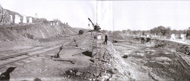
 Sunshine and District Historical Society Incorporated
Photographs (1928), 'QUARTER MILE' BRIDGE Construction, 1928
One man lost his life during the building of this bridge. The bridge was constructed by the Victorian Railways between 1927 to 1929 to carry a new double track goods line. This enabled trains from all parts of the state except Gippsland to have direct access to the Tottenham marshalling and sorting yards. These yards were constructed in the 1920's to relieve congestion in the Melbourne Yard near Spencer Street station. The congestion was being caused by the construction of suburban passenger platforms associated with the electrification of the suburban railway network. Initially the bridge was for goods trains but during the Second World War it was also used by troop trains. When the standard gauge line was built in 1962 all trains to Albury and Sydney have used this route, thus avoiding travelling through Essendon and Pascoe Vale on the suburban tracks. The standard gauge track across the bridge took the place of one of the broad gauge tracks so broad gauge trains crossing the bridge in either direction have to now use the same track. The bridge is 1,257 feet (383.13 metres) long and 180 feet (54.86 metres) above the water level. It is just 63 feet (19.2 metres) short of a quarter mile in length between abutments. There is a similar bridge on the same railway line crossing the Moonee Ponds Creek between Gowenbrae and Glenroy, however it is smaller at 1060 feet (323.08 metres) length and 115 feet (35.05) height.The bridge is now Victorian Heritage Registered under Number: H1197, and Heritage Overlay Numbers HO5, and HO107. On the Heritage Register it is named RAIL BRIDGE (ALBION VIADUCT). According to the Heritage Report the bridge is scientifically and architecturally important because of its large size, and because of the cost effective design features such as two girders per span (one for each track), the K bracing in the towers, and the broad flange beams as columns. When it was being built it was the largest trestle bridge in Australia, and until the Sydney Harbour bridge was constructed it was the highest railway bridge.Five B&W yellowing photos showing stages of construction of the Maribyrnong River Viaduct known as the Trestle Bridge but mainly known locally as the QUARTER MILE BRIDGE. It is a railway only bridge which runs over the Maribyrnong River between Sunshine North and Keilor East. A sixth image, which is not part of this set of photos, is included to show what the completed bridge looks like. -
 Kew Historical Society Inc
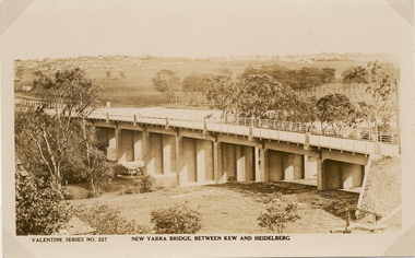
Postcard, Valentine Publishing Co Pty Ltd, New Yarra Bridge, Between Kew and Heidelberg, 1926-1930
Without bridges, Kew remained cut off from the City of Melbourne, only being accessible by Punt. Private and public bridges were constructed from the 1850s, beginning with the Hawthorn Bridge linking Bridge and Burwood Roads. A bridge across the Yarra at Burke Road was created as early as 1873. Since that first wooden bridge, a number of later bridges, typically on concrete pylons have been built, in 1926 and again during the 1970s.Angle view of the new Yarra bridge [ie. The Burke Road bridge] taken from the Kew side, showing the bridge’s structure. Trees line the river’s edge. In the distance can be seen a distant line of houses stretching to the horizon. The river appears to have an S-shaped bend beyond the bridge. The postcard, No. 227, was produced by the Valentine Publishing Co. Pty Ltd., of Queen Street, Melbourne.burke road bridge - kew (vic), bridges - kew (vic) -
 Kew Historical Society Inc
Photograph - Dight's Falls, 1924
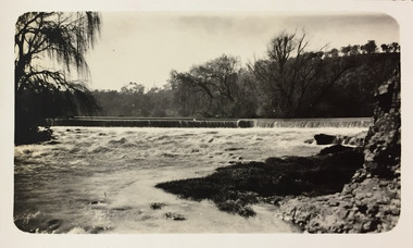
Henry Beater Christian (1886-1962) , was a descendant of one of the earliest settler families in Kew. Employed at the Kew Asylum as a 'public servant', he was a skilled amateur photographer, photographing numerous scenes in Kew and on his travels around Victoria. The majority of his photographs date from 1916 to 1929. His finest photographs are housed in two photograph albums. Digital copy of a photograph from page 9 of the 47-page photograph album containing 261 gelatinous silver images, loaned by Diane Washfold with permission given to digitise and hold a copy in our collection. The point-of-view selected by the photographer, Henry Christian, is of Dight's Falls on the Yarra River from the Kew side. Dight's Falls separates the saline and fresh water sections of the river. "Studley Park / Kew"henry beater christian (1886-1962), landscape photography, kew (vic.) — yarra river, christian-washfold collection, photograph albums, yarra river -- studley park (vic.), dight's falls -
 Kew Historical Society Inc
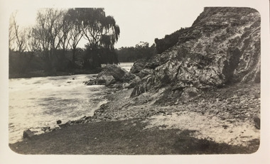
Photograph - Yarra River below Dight's Falls, 1924
Henry Beater Christian (1886-1962) , was a descendant of one of the earliest settler families in Kew. Employed at the Kew Asylum as a 'public servant', he was a skilled amateur photographer, photographing numerous scenes in Kew and on his travels around Victoria. The majority of his photographs date from 1916 to 1929. His finest photographs are housed in two photograph albums. Digital copy of a photograph from page 9 of the 47-page photograph album containing 261 gelatinous silver images, loaned by Diane Washfold with permission given to digitise and hold a copy in our collection. The point-of-view selected by the photographer, Henry Christian, is below Dight's Falls on the Yarra River from the Kew side. Dight's Falls separates the saline and fresh water sections of the river. "Studley Park / Kew"henry beater christian (1886-1962), landscape photography, kew (vic.) — yarra river, christian-washfold collection, photograph albums, yarra river -- studley park (vic.), dight's falls -
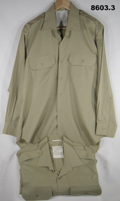 Bendigo Military Museum
Uniform - SHIRTS, SERVICE DRESS, ARMY, 1982, 1983, 1991
1. 2. 3. Shirts - khaki colour, cotton/polyester, long sleeves with button cuff, collar, shoulder epaulettes, two front pockets with button down flap. Plastic buttons. White cotton fabric manufacturers label, back below collar. 2. Left sleeve - fabric shoulder patch. Rising Sun Badge with Queen's Crown and lettering embroidery. "THE AUSTRALIAN ARMY".Manufacturer's information - black ink print. 1. "A.G.C.F./ VIC 1982/ ^ / 8405.66.088.7068/ SIZE 41/84/. SERVICE NO./ NAME/ DO NOT BOIL. OR WRING/ MACHINE WASHABLE/ DRIP DRY IRON NIGHTLY/ WITH WARM IRON". 2. "A.G.C.F./ VIC 1983/ ^/ 8405.66.088.7065/ SIZE 40/88". SERVICE NO./ NAME/ DO NOT BOIL. OR WRING/ MACHINE WASHABLE/ DRIP DRY IRON NIGHTLY/ WITH WARM IRON". 3. "ADI/ VIC 1991/ ^/ 8405.66.088.7102/ SERVICE NO./ NAME/ 65% POLYESTER/ 35% COTTON" "DO NOT BOIL. OR WRING/ MACHINE WASHABLE/ DRIP DRY IRON NIGHTLY/ WITH WARM IRON". uniforms, army, service dress, shirts, passchendaele barracks trust -
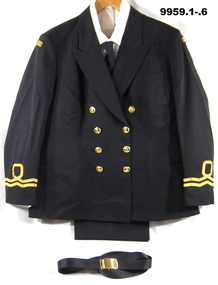 Bendigo Military Museum
Uniform - WINTER CEREMONIAL - NAVY CADETS, Australian Defence Industries, 1992, 2002
Uniform issued to Lieutenant ANC (Australian Navy Cadets) "Patricia Ibbotson", No. 1005777. Commanding Officer of Training Ship Bendigo. Enlisted 26/2/2004 - Admin Officer, 2IC. Acting CO June 2012 Commanding Officer 16/10/2012. Retired 26/02/2016.1. Jacket - Black winter ceremonial, wool/polyester fabric, double breasted with 8 gold plastic buttons embossed with an anchor. Two wavy gold stripes just above sleeve hems, denotes rank of Lieutenant. One stripe has a loop. There are black shoulder flashes with the words "Australian Navy Cadets" embroidered in gold. 2. Trousers - Black wool/polyester fabric with side pockets. Fob pocket, back pocket and belt loops. Nylon and metal zipper fly, Black polyester pocket lining. 3. Shirt - long sleeved with cuff, white cotton/polyester fabric, collar, front breast pockets with button down flap. Shoulder epaulettes, plastic buttons. 4. Shirt - white, short sleeved with shoulder boards. Cotton/polyester fabric, collar shoulder epaulettes, two front pockets, white plastic buttons. Shoulder boards gold ribbon on black fabric with gold plastic embossed buttons. 6. Belt - black with gold buckle. 7. Hat - Tricorne for female officer - black and white colour fabric. Black brim, white crown with black polyester lining. On front is a cloth Officers badge featuring gold laurel wreath surrounding a silver anchor. On top of that is a gold crown with padded insert of red velvet. Around the base is embroidered dots of red, blue and green representing gems. Manufacturers label - black in print - illegible. Handwritten owner's, blue ink pen "IBBOTSON". Manufacturer's label - black ink print on white cotton fabric. 1. "ADI/ 1992/ SIZE 115s/ Bust - 115cm/ Waist 90 cm/ 8410-66-134-3810/ Wool/polyester/ Service No/ Name/DRY CLEAN ONLY." 2. ADA/ 2002/ ^/ NSN 8405 66 137 9251/ Wool/Polyester/ Size: 104L/ Waist:104/ Seat: 125/ NO/ NAME/ DRY CLEAN ONLY. 5. White print on black fabric "AUSTRALIAN TIE CO/ MADE IN AUSTRALIA/ 65% POLYESTER/ 35% VISCOSE/ MADE IN AUSTRALIA/ DRY CLEAN ONLY".uniform, anc, ts bendigo, patricia ibbotson -
 Lake Bolac & District Historical Society
Black and white photograph, Fiery Creek Entrance
Fiery Creek inlet to Lake Bolac during the 1997-2010 drought. Photograph taken from the dry lake-bed looking up the creek, towards the south.lake bolac, fiery creek, 1997-2010 drought -
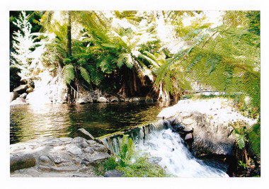 Marysville & District Historical Society
Photograph (item) - Colour photograph, Pre 2009
A colour photograph of the pool at the base of the Steavenson Falls in Marysville in Victoria. A colour photograph of the pool at the base of the Steavenson Falls in Marysville in Victoria. The Steavenson Falls is named after the Victorian Assistant Commissioner of Roads and Bridges, John Steavenson who arrived in Victoria in the early 1860s.steavenson falls, waterfalls, marysville, victoria, john steavenson -
Glenelg Shire Council Cultural Collection
Negative - Negative -Donovan's Landing Nelson, Victoria, c. 1936
Negative for a black and white photograph. Image shows Donovan's landing, Nelson Victoria. Group of 7 people standing on a small landing, river, boat sheds in background. -
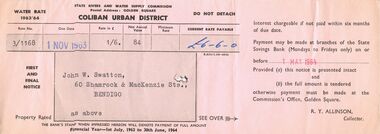 Bendigo Historical Society Inc.
Document - J W SWATTON COLLECTION: STATE RIVERS AND WATER COMMISSION ACCOUNT
Account issued by State Rivers And Water Supply Commision for water rates 1963/64 addressed to J. W. Swatton 60 Shamrock and MacKenzie Streets, Bendigo.essential services, water supply -
Port Melbourne Historical & Preservation Society
Plan - Possible maritime shed, Borough of Sandridge, 1870s
An identified building plan - presumably a maritime shed (front elevation faces "the river") - proving front, traverse and longitudinal sections. Possibly two buildings. Plan No. 3.Charles Clay B.S. [Borough Surveyor]:W. Weatherston[e]built environment - civic, piers and wharves, charles clay, william weatherston[e] -
Port Melbourne Historical & Preservation Society
Photograph - Ships at Station Pier, Port Melbourne, Ranchi (inner west), Strathnaver (outer west) and Ormonde (inner east), Glen Stuart, 1950s
One of nine photographs taken of various ships at Port Melbourne and river berths in the early 1950s: Station Pier, Ranchi (iw), Strathnaver (ow) and Ormonde (ie)piers and wharves - station pier, transport - shipping, ranchi, strathnaver, ormonde, nairana -
 Nillumbik Shire Council
Painting: Guy STUART (b.1942 ACT), Guy Stuart, Tunnel by the Yarra, 2004
An abstract painting of the Yarra River from Pound Bend in Warrandyte. The painting is quite expressive, linear and gestural in style. Muted, neutral tones of greens, browns and reds. -
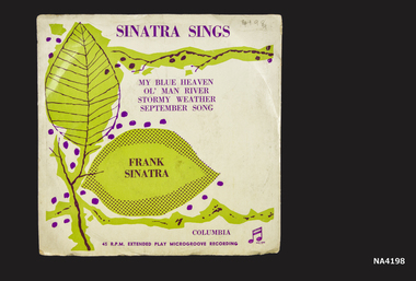 Whitehorse Historical Society Inc.
Audio - 45 R.P.M. Record, c 1950's
Owned - purchased and played by Barbara Gardiner 1950'sCircular record 45 R.P.M. Frank Sinatra. Four songs with orchestral accompaniment.|Stormy weather|September Song|My Blue Heaven|Ol' man RiverColumbiamusical instruments, accessories -
 Kew Historical Society Inc
Photograph, Railway Viaduct, c.1900
Railway viaduct, Yarra River, linking Kew and Fairfield. Built by John Monash for the Outer Circle Railway. In 1930 converted into the Chandler Highway Bridge for vehicular traffic. Annotations on reverse: "KH-71. Outer Circle Railway Bridge (over Yarra) looking from Kew side to site of Paper Mills, Alphington.outer circle railway, railway viaduct (kew), john monash, chandler highway bridge -
 Kew Historical Society Inc
Photograph - Yarra in Flood - Belford & Kilby Farms, 1903
The Yarra Valley in what was previously called North Kew, but is now East Kew, was frequently subjected to flooding. Apart from some development on higher ground, the City of Kew regularly introduced restrictions on development and the building of housing in the area because of flood levels. Panoramic photographic positive of North Kew where the Belford and Kilby Farms were located on the south side of the Yarra River. This photo is a copy of the original photo in the collection.floods -- yarra -- 1903, kew golf course, greenacres golf course -
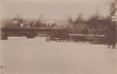 Sunbury Family History and Heritage Society Inc.
Photograph
The post card is a record of a time when the Jacksons Creek flooded and the water almost reached the two arches on the Macedon Street Bridge. The Goonawarra Winery buildings can be seen in the back ground.A sepia photograph in post card format of a river in flood with the water almost reaching the two arches on the stone bridge. Farm buildings can be seen in the middle distance.JACKSON'S CREEK IN FLOOD SUNBURYmacedon street bridge, jacksons creek, goonawarra winery -
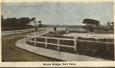 Port Fairy Historical Society Museum and Archives
Photograph - Postcard, Moyne bridge
Photograph hand tinted of the Moyne river road bridge taken from Gipps Street showing house on the far bank on the right side taken for use as a PostcardMoyne Bridgemoyne bridge 1910, moyne river, traffic, gipps street -
 Wodonga & District Historical Society Inc
Album - Hume Reservoir Australia Album - Excavations for foundations of spillway, September 1921
This set of photos is from a leather bound album bearing the inscription "HUME RESERVOIR AUSTRALIA" plus 'The Rt. Hon. L. C. M. S. Amery, P. C., M .P.' all inscribed in gold. It was presented to The Rt. Hon. L. C. M. S. Amery, P. C., M. P, Secretary of State for Dominion Affairs on the occasion of his visit to the Hume Reservoir on 2nd November 1927. This album is of local and national significance as it documents the planning and development of the Hume Reservoir up to 1927. It was the largest water reservoir in the British Empire. The album records the pioneering engineering work that went into its construction.DEPARTMENT OF PUBLIC WORKS, N.S.W. RIVER MURRAY WATERS SCHEME. HUME RESERVOIR. 6. Excavation in progress for foundations of outlet and spillway sections of dam. September 1921.hume reservoir australia, river murray waters scheme, hume weir diagrams, hume plan details -
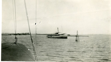 Lakes Entrance Historical Society
Photograph - S.S. Gippsland, 1933
Second copy shows rear view of grounded boat.Black and white photograph showing S S Gippsland aground in Lake King at mouth of Mitchell River, taken from another boat. Lakes Entrance Victoria waterways, ships and shipping, shipwrecks -
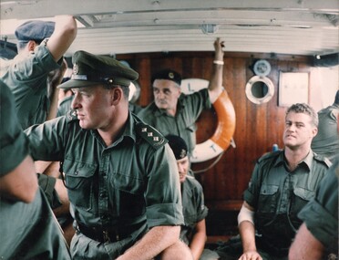 National Vietnam Veterans Museum (NVVM)
Photograph, Gibbons, Denis, L/C Vernon Sturdie
Denis Gibbons (1937 – 2011) Trained with the Australian Army, before travelling to Vietnam in January 1966, Denis stayed with the 1st Australian Task Force in Nui Dat working as a photographer. For almost five years Gibbons toured with nine Australian infantry battalions, posting compelling war images from within many combat zones before being flown out in late November 1970 after sustaining injuries. The images held within the National Vietnam Veterans Museum make up the Gibbons Collection. A coloured photograph of Officers & men on Landing Craft Vernon Sturdie look pensive as they observe the bank of the Mekong River whilst ferrying supplies to the ARVN at Long Binh. photograph, mekong river, arvn, long binh, gibbons collection catalogue, landing craft vernon sturdie, australian soldiers, denis gibbons -
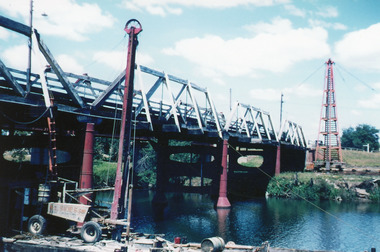 Lakes Entrance Historical Society
Photograph - Bridges, Scarce, Keith, 1955
Colour photograph of the W L Sides and Son drilling rig beside the bridge over the Mitchell River, testing for foundations for the planned new bridge. Bairnsdale Victoriabridges, waterways, machinery -
Lakes Entrance Historical Society
Book, Smyth Chris, Baltuiks Isabel, Roberts Lorelle, Roberts Maurice, Stooping Stones a Guide to Mallacoota and District, 1986
Description guide to Mallacoota Victoria and the surrounding district of far East Gippsland including Genoa Gipsy Point and Betka River illustrated with sketch maps photographs and sketches.township -
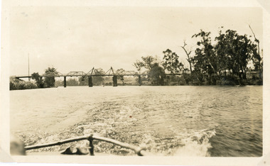 Lakes Entrance Historical Society
Photograph - Bridges, 1925
Photo taken same year Swan Reach bridge collapsed 16 November 1925Black and white photograph of the lifting bridge over the Tambo River taken from the stern of a boat. A tourist launch under the bridge in distance. Swan Reach Victoriabridges, waterways -
 Melbourne Tram Museum
Negative, Wal Jack, 15/03/1945 12:00:00 AM
Black and white negative, by Wal Jack, of Scrubber 8 in Maribyrnong Road. Wal's album notes that the photo is near the River terminus and dated 15-3-1945.trams, tramways, maribyrnong rd, scrubber tram, work trams, tram 8 -
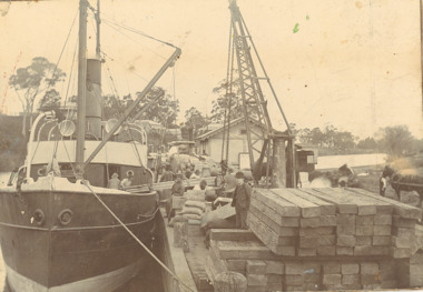 Lakes Entrance Historical Society
Photograph - SS Glenelg c1900, 1900 c
Steamer believed to be SS Glenelg owned by G A and J Carpenter Ellerker and Co and Jackson 1898Sepia toned photograph mounted on heavy cardboard showing an unnamed steamer being either loaded or unloaded with timber at busy Mitchell River wharf Bairnsdale Victoriaboats and boating, gippsland lakes, jetties, wharfs -
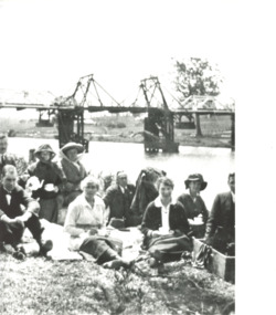 Lakes Entrance Historical Society
Photograph, Myrtle Grant, 1920 c
Myrtle is in centre with white blouseBlack and white photograph showing Myrtle Grant and eight people having a picnic on bank of Tambo River with original bascule bridge in background at Swan Reach Victoriagenealogy, families -
Coal Creek Community Park & Museum
Advertisement
Large cardboard advertisement with writing, diagram and pictures of boxes in black, yellow, red, green and orange.for better free gifts Save Empire Soap Trade Marks from Demon Cleaners, Empire Soap Body Guard. It is the standard of quality of Empire Soap free gifts which makes the saving of Empire Trade Marks Empire trade