Showing 5851 items
matching farm
-
 Kew Historical Society Inc
Photograph - Flooding of Willsmere Park from Yarra, 1993
Willsmere Park is bounded by the the Yarra River, Green Acres Golf Club, Willow Grove and the Eastern Freeway. The land on which the park is now situated was bought by Thomas Wills at the Crown Land Sales of 1846 (Section 56). From the 1840s to the 1940s it was intensively farmed. The park is dominated by very large playing fields, while planting to the southern boundary was undertaken when the Eastern Freeway was built. It is only along the banks of the Yarra that there is any remnant native vegetation. Willsmere Park is of significance as an area of open land that remains from the flood plain that once dominated northern Kew. (Source: Kew Conservation Study, 1988)Original colour small format polaroid photograph of flooding in Willsmere Park resulting from heavy rain on 15 September 1993."Flooding of Willsmere Park from Yarra 16.9.93"yarra river -- floods -- kew (vic.), willsmere park -
 Kew Historical Society Inc
Photograph - Willsmere [Kew] Billabong, 1993
Willsmere Park is bounded by the the Yarra River, Green Acres Golf Club, Willow Grove and the Eastern Freeway. The land on which the park is now situated was bought by Thomas Wills at the Crown Land Sales of 1846 (Section 56). From the 1840s to the 1940s it was intensively farmed. The park is dominated by very large playing fields, while planting to the southern boundary was undertaken when the Eastern Freeway was built. It is only along the banks of the Yarra that there is any remnant native vegetation. Willsmere Park is of significance as an area of open land that remains from the flood plain that once dominated northern Kew. (Source: Kew Conservation Study, 1988)Original colour small format polaroid photograph of Willsmere [Kew] Billabong on September 1993."Willsmere Billabong 16.9.93"yarra river -- floods -- kew (vic.), willsmere park -
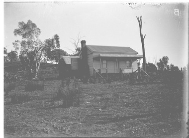 Wodonga & District Historical Society Inc
Negative - Haeusler Glass Negatives Collection - Louis Haeusler's house in Wodonga West, c1910
The Wodonga Historical Society Haeusler Collection provides invaluable insight into life in late nineteenth and early twentieth century north east Victoria. The collection comprises manuscripts, personal artefacts used by the Haeusler family on their farm in Wodonga, and a set of glass negatives which offer a unique visual snapshot of the domestic and social lives of the Haeusler family and local Wodonga community. This digital image was produced from one of the glass negatives that form part of the collection, probably taken by Louis Haeusler (b.1887) with the photographic equipment in the Wodonga Historical Society Haeusler Collection. This house was owned and built by Louis Haeusler in Wodonga West,This item is unique and has well documented provenance and a known owner. It forms part of a significant and representative historical collection which reflects the local history of Wodonga. It contributes to our understanding of domestic and family life in early twentieth century Wodonga, as well as providing interpretative capacity for themes including local history and social history.Digital image created from the Haeusler Glass negative collection. A small wooden house built in a cleared area. This house was built and owned by Louis Haeusler C. 1910wodonga pioneers, haeusler family, glass negatives, dry plate photography, louis haeusler, pioneer housing -
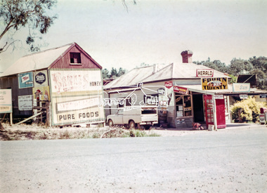 Eltham District Historical Society Inc
Photograph, Doney's General Store, Research, c.1969
Roadside buildings, formerly Doney's General Store. Doney's operated from the 1880s through to the late 1960s. It was situated at the head of the present day Research shops on Main Road near the corner of Raglan Road. By the 1960s it was under new ownership. The Store had a residence at the back. Signs promote The Herald and Sun newspapers, four 'n twenty pies, coca cola and more. A public phone box is in the front of the store. Beside the store is possibly an old farm building with more signs advertising honey, Streets, Tarax and a local bottle dump. Lyn Dodkins used to work in the Store after school.Digital file onlygeneral store, research (vic.), milkbar, lyn dodkins -
 Eltham District Historical Society Inc
Opening of Meruka Childcare Co-operative, Meruka Park, 5 Meruka Dr, Eltham, April 1994
In 1919 J.B. North, a violinist with the then Melbourne Symphonic Orchestra, and Monsieur Leon Lambert, a French architect, who later designed the Glaciarium Ice Skating Rink, purchased three available farms, Looker's, Wright's and Taylor's, approximately 60 acres, the area running along the creek and being bordered by the present day Ryans Road, Karingal Drive and Sherbourne Road. The farms were used for orchards and market gardens. Leon Lambert designed and built two homes on the farm site, one for the North family, ‘Tralford’, and the other, ‘Glen Ellen’, for himself and his wife. The homes were considered as "brother and sister" and they each included in their design an identical bay window in the main living area. "Glen Ellen" originally comprised kitchen, lounge room, inglenook, dining room, bath room and sleepout. Although the home has been extended over the years, much of the original architecture has been retained including timber panelling and three fireplaces. The land was subdivided in approximately 1966 with "Glen Ellen" retaining approximately one half acre of land fronting Meruka Drive. The property then passed from the Charleston family to Gerald and Margaret Sutton in 1976 and again was sold in 1980 and lastly sold again in 1994. The Norths named their house 'Tralford'. According to Marjorie North, the name Meruka was suggested by Alan Gardner and so was apparently not used by the North family. The name appears to be of Indian origin and its connection with the land is not known. ‘Tralford’ stayed in the North family for many years. Eltham Council acquired the house to create Meruka Park. The house was used for some years by the Council as a community arts facility and as emergency accommodation. It fell into disrepair and was demolished about 1990. The Meruka Child Care Centre has been built on the site and incorporates some of the architectural features of the old house. The Co-op was opened in April 1994. The original drive flanked by large old cypress trees remains. These trees are considered to be of local heritage significance and for this reason Meruka Park is covered by a Heritage Overlay under the Nillumbik Planning Scheme. Part of the park has been preserved as habitat for rare local flora. LL's house, named ‘Glen Ellen’, remains in a well-preserved state and fronts Meruka Drive.cr pam sladden, eltham, meruka child care co-operative, meruka house, meruka park -
 Eltham District Historical Society Inc
Opening of Meruka Childcare Co-operative, Meruka Park, 5 Meruka Dr, Eltham, April 1994
In 1919 J.B. North, a violinist with the then Melbourne Symphonic Orchestra, and Monsieur Leon Lambert, a French architect, who later designed the Glaciarium Ice Skating Rink, purchased three available farms, Looker's, Wright's and Taylor's, approximately 60 acres, the area running along the creek and being bordered by the present day Ryans Road, Karingal Drive and Sherbourne Road. The farms were used for orchards and market gardens. Leon Lambert designed and built two homes on the farm site, one for the North family, ‘Tralford’, and the other, ‘Glen Ellen’, for himself and his wife. The homes were considered as "brother and sister" and they each included in their design an identical bay window in the main living area. "Glen Ellen" originally comprised kitchen, lounge room, inglenook, dining room, bath room and sleepout. Although the home has been extended over the years, much of the original architecture has been retained including timber panelling and three fireplaces. The land was subdivided in approximately 1966 with "Glen Ellen" retaining approximately one half acre of land fronting Meruka Drive. The property then passed from the Charleston family to Gerald and Margaret Sutton in 1976 and again was sold in 1980 and lastly sold again in 1994. The Norths named their house 'Tralford'. According to Marjorie North, the name Meruka was suggested by Alan Gardner and so was apparently not used by the North family. The name appears to be of Indian origin and its connection with the land is not known. ‘Tralford’ stayed in the North family for many years. Eltham Council acquired the house to create Meruka Park. The house was used for some years by the Council as a community arts facility and as emergency accommodation. It fell into disrepair and was demolished about 1990. The Meruka Child Care Centre has been built on the site and incorporates some of the architectural features of the old house. The Co-op was opened in April 1994. The original drive flanked by large old cypress trees remains. These trees are considered to be of local heritage significance and for this reason Meruka Park is covered by a Heritage Overlay under the Nillumbik Planning Scheme. Part of the park has been preserved as habitat for rare local flora. LL's house, named ‘Glen Ellen’, remains in a well-preserved state and fronts Meruka Drive.eltham, meruka child care co-operative, meruka house, meruka park, cr. peter graham, peter staples, richard allen, sheryl garbutt, bill penrose -
 Eltham District Historical Society Inc
Opening of Meruka Childcare Co-operative, Meruka Park, 5 Meruka Dr, Eltham, April 1994
In 1919 J.B. North, a violinist with the then Melbourne Symphonic Orchestra, and Monsieur Leon Lambert, a French architect, who later designed the Glaciarium Ice Skating Rink, purchased three available farms, Looker's, Wright's and Taylor's, approximately 60 acres, the area running along the creek and being bordered by the present day Ryans Road, Karingal Drive and Sherbourne Road. The farms were used for orchards and market gardens. Leon Lambert designed and built two homes on the farm site, one for the North family, ‘Tralford’, and the other, ‘Glen Ellen’, for himself and his wife. The homes were considered as "brother and sister" and they each included in their design an identical bay window in the main living area. "Glen Ellen" originally comprised kitchen, lounge room, inglenook, dining room, bath room and sleepout. Although the home has been extended over the years, much of the original architecture has been retained including timber panelling and three fireplaces. The land was subdivided in approximately 1966 with "Glen Ellen" retaining approximately one half acre of land fronting Meruka Drive. The property then passed from the Charleston family to Gerald and Margaret Sutton in 1976 and again was sold in 1980 and lastly sold again in 1994. The Norths named their house 'Tralford'. According to Marjorie North, the name Meruka was suggested by Alan Gardner and so was apparently not used by the North family. The name appears to be of Indian origin and its connection with the land is not known. ‘Tralford’ stayed in the North family for many years. Eltham Council acquired the house to create Meruka Park. The house was used for some years by the Council as a community arts facility and as emergency accommodation. It fell into disrepair and was demolished about 1990. The Meruka Child Care Centre has been built on the site and incorporates some of the architectural features of the old house. The Co-op was opened in April 1994. The original drive flanked by large old cypress trees remains. These trees are considered to be of local heritage significance and for this reason Meruka Park is covered by a Heritage Overlay under the Nillumbik Planning Scheme. Part of the park has been preserved as habitat for rare local flora. LL's house, named ‘Glen Ellen’, remains in a well-preserved state and fronts Meruka Drive.eltham, meruka child care co-operative, meruka house, meruka park, cr. john cohen -
 Eltham District Historical Society Inc
Opening of Meruka Childcare Co-operative, Meruka Park, 5 Meruka Dr, Eltham, April 1994
In 1919 J.B. North, a violinist with the then Melbourne Symphonic Orchestra, and Monsieur Leon Lambert, a French architect, who later designed the Glaciarium Ice Skating Rink, purchased three available farms, Looker's, Wright's and Taylor's, approximately 60 acres, the area running along the creek and being bordered by the present day Ryans Road, Karingal Drive and Sherbourne Road. The farms were used for orchards and market gardens. Leon Lambert designed and built two homes on the farm site, one for the North family, ‘Tralford’, and the other, ‘Glen Ellen’, for himself and his wife. The homes were considered as "brother and sister" and they each included in their design an identical bay window in the main living area. "Glen Ellen" originally comprised kitchen, lounge room, inglenook, dining room, bath room and sleepout. Although the home has been extended over the years, much of the original architecture has been retained including timber panelling and three fireplaces. The land was subdivided in approximately 1966 with "Glen Ellen" retaining approximately one half acre of land fronting Meruka Drive. The property then passed from the Charleston family to Gerald and Margaret Sutton in 1976 and again was sold in 1980 and lastly sold again in 1994. The Norths named their house 'Tralford'. According to Marjorie North, the name Meruka was suggested by Alan Gardner and so was apparently not used by the North family. The name appears to be of Indian origin and its connection with the land is not known. ‘Tralford’ stayed in the North family for many years. Eltham Council acquired the house to create Meruka Park. The house was used for some years by the Council as a community arts facility and as emergency accommodation. It fell into disrepair and was demolished about 1990. The Meruka Child Care Centre has been built on the site and incorporates some of the architectural features of the old house. The Co-op was opened in April 1994. The original drive flanked by large old cypress trees remains. These trees are considered to be of local heritage significance and for this reason Meruka Park is covered by a Heritage Overlay under the Nillumbik Planning Scheme. Part of the park has been preserved as habitat for rare local flora. LL's house, named ‘Glen Ellen’, remains in a well-preserved state and fronts Meruka Drive.eltham, meruka child care co-operative, meruka house, meruka park, rob hauser -
 Eltham District Historical Society Inc
Opening of Meruka Childcare Co-operative, Meruka Park, 5 Meruka Dr, Eltham, April 1994
In 1919 J.B. North, a violinist with the then Melbourne Symphonic Orchestra, and Monsieur Leon Lambert, a French architect, who later designed the Glaciarium Ice Skating Rink, purchased three available farms, Looker's, Wright's and Taylor's, approximately 60 acres, the area running along the creek and being bordered by the present day Ryans Road, Karingal Drive and Sherbourne Road. The farms were used for orchards and market gardens. Leon Lambert designed and built two homes on the farm site, one for the North family, ‘Tralford’, and the other, ‘Glen Ellen’, for himself and his wife. The homes were considered as "brother and sister" and they each included in their design an identical bay window in the main living area. "Glen Ellen" originally comprised kitchen, lounge room, inglenook, dining room, bath room and sleepout. Although the home has been extended over the years, much of the original architecture has been retained including timber panelling and three fireplaces. The land was subdivided in approximately 1966 with "Glen Ellen" retaining approximately one half acre of land fronting Meruka Drive. The property then passed from the Charleston family to Gerald and Margaret Sutton in 1976 and again was sold in 1980 and lastly sold again in 1994. The Norths named their house 'Tralford'. According to Marjorie North, the name Meruka was suggested by Alan Gardner and so was apparently not used by the North family. The name appears to be of Indian origin and its connection with the land is not known. ‘Tralford’ stayed in the North family for many years. Eltham Council acquired the house to create Meruka Park. The house was used for some years by the Council as a community arts facility and as emergency accommodation. It fell into disrepair and was demolished about 1990. The Meruka Child Care Centre has been built on the site and incorporates some of the architectural features of the old house. The Co-op was opened in April 1994. The original drive flanked by large old cypress trees remains. These trees are considered to be of local heritage significance and for this reason Meruka Park is covered by a Heritage Overlay under the Nillumbik Planning Scheme. Part of the park has been preserved as habitat for rare local flora. LL's house, named ‘Glen Ellen’, remains in a well-preserved state and fronts Meruka Drive.eltham, meruka child care co-operative, meruka house, meruka park, irene bogle -
 Eltham District Historical Society Inc
Opening of Meruka Childcare Co-operative, Meruka Park, 5 Meruka Dr, Eltham, April 1994
In 1919 J.B. North, a violinist with the then Melbourne Symphonic Orchestra, and Monsieur Leon Lambert, a French architect, who later designed the Glaciarium Ice Skating Rink, purchased three available farms, Looker's, Wright's and Taylor's, approximately 60 acres, the area running along the creek and being bordered by the present day Ryans Road, Karingal Drive and Sherbourne Road. The farms were used for orchards and market gardens. Leon Lambert designed and built two homes on the farm site, one for the North family, ‘Tralford’, and the other, ‘Glen Ellen’, for himself and his wife. The homes were considered as "brother and sister" and they each included in their design an identical bay window in the main living area. "Glen Ellen" originally comprised kitchen, lounge room, inglenook, dining room, bath room and sleepout. Although the home has been extended over the years, much of the original architecture has been retained including timber panelling and three fireplaces. The land was subdivided in approximately 1966 with "Glen Ellen" retaining approximately one half acre of land fronting Meruka Drive. The property then passed from the Charleston family to Gerald and Margaret Sutton in 1976 and again was sold in 1980 and lastly sold again in 1994. The Norths named their house 'Tralford'. According to Marjorie North, the name Meruka was suggested by Alan Gardner and so was apparently not used by the North family. The name appears to be of Indian origin and its connection with the land is not known. ‘Tralford’ stayed in the North family for many years. Eltham Council acquired the house to create Meruka Park. The house was used for some years by the Council as a community arts facility and as emergency accommodation. It fell into disrepair and was demolished about 1990. The Meruka Child Care Centre has been built on the site and incorporates some of the architectural features of the old house. The Co-op was opened in April 1994. The original drive flanked by large old cypress trees remains. These trees are considered to be of local heritage significance and for this reason Meruka Park is covered by a Heritage Overlay under the Nillumbik Planning Scheme. Part of the park has been preserved as habitat for rare local flora. LL's house, named ‘Glen Ellen’, remains in a well-preserved state and fronts Meruka Drive.eltham, meruka child care co-operative, meruka house, meruka park, cr bob manuell, matthew rodscholler -
 Eltham District Historical Society Inc
Opening of Meruka Childcare Co-operative, Meruka Park, 5 Meruka Dr, Eltham, April 1994
In 1919 J.B. North, a violinist with the then Melbourne Symphonic Orchestra, and Monsieur Leon Lambert, a French architect, who later designed the Glaciarium Ice Skating Rink, purchased three available farms, Looker's, Wright's and Taylor's, approximately 60 acres, the area running along the creek and being bordered by the present day Ryans Road, Karingal Drive and Sherbourne Road. The farms were used for orchards and market gardens. Leon Lambert designed and built two homes on the farm site, one for the North family, ‘Tralford’, and the other, ‘Glen Ellen’, for himself and his wife. The homes were considered as "brother and sister" and they each included in their design an identical bay window in the main living area. "Glen Ellen" originally comprised kitchen, lounge room, inglenook, dining room, bath room and sleepout. Although the home has been extended over the years, much of the original architecture has been retained including timber panelling and three fireplaces. The land was subdivided in approximately 1966 with "Glen Ellen" retaining approximately one half acre of land fronting Meruka Drive. The property then passed from the Charleston family to Gerald and Margaret Sutton in 1976 and again was sold in 1980 and lastly sold again in 1994. The Norths named their house 'Tralford'. According to Marjorie North, the name Meruka was suggested by Alan Gardner and so was apparently not used by the North family. The name appears to be of Indian origin and its connection with the land is not known. ‘Tralford’ stayed in the North family for many years. Eltham Council acquired the house to create Meruka Park. The house was used for some years by the Council as a community arts facility and as emergency accommodation. It fell into disrepair and was demolished about 1990. The Meruka Child Care Centre has been built on the site and incorporates some of the architectural features of the old house. The Co-op was opened in April 1994. The original drive flanked by large old cypress trees remains. These trees are considered to be of local heritage significance and for this reason Meruka Park is covered by a Heritage Overlay under the Nillumbik Planning Scheme. Part of the park has been preserved as habitat for rare local flora. LL's house, named ‘Glen Ellen’, remains in a well-preserved state and fronts Meruka Drive.eltham, meruka child care co-operative, meruka house, meruka park, cr pam sladden, mandy press -
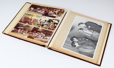 Melbourne Legacy
Album - Photo album, A record of comradeship activities, 1970s-1980s
This album of Comradeship activities was compiled by Legatee Fred Holdsworth. It contains photographs, newspaper cuttings and ephemera relating to various “Comradeship” activities (social gatherings) held throughout the 1970s and early 1980s. Items included various events legatees participated in. First few pages had photos from a gathering at Cruden Farm on 15 May 1977. Cruden Farm was owned by Elisabeth Murdoch, the mother-in-law of Legatee Geoff Handbury. It appears there was a kite flying contest. Names are not listed. Three photos were from Queensland where Legatee Wal Escott had retired at Mundoona apartments, Noosa Heads, one photo shows him with Lorna Grimwade on 6/10/1979. There is a black and white photo of Max Armstrong, Rex Hall, Harry Burton, Warren Hardy riding horses in the Anzac Day march. The year is not known but an accompanying newspaper article mentions that they had been riding every year for 13 years on horses loaned by the police mounted branch. The newspaper clipping shows another photo of the four. A photo of seven legatees including David Carter were at the Numurkah Annual meeting in 1978. There are 8 photos of a gathering of Legatees and their wives at Stanhope in 1979. A photo of a Christmas party at Chaucers in 1979 was missing from the page, it has shown Choirmaster Reg Thomson and Choristers; Rob Allison, Bruce Hall, Les Patch, Bill Seager, David Syme and Ron Austin; with the M.C. being Fred Holdsworth. There was a trip to a trout farm in Alexandra Yea area in February 1978. At a comradeship evening there a photos showed the Comradeship committee of Harold Berg, John Cooper and Fred Holdsworth. Also photos from Anzac Night in 1980 and 1981. Plus other gathering at people's homes. A black and white photo of men in formal black tie, is from a night at the Windsor Hotel to farewell Sit Thomas White to become Australia's High Commissioner in London. Left to right are Sir Archie Michaelis, Sir John Latham, Sir Thomas White, Lt Col Donovan Joynt and Sir Stanley Savige. At the 1981 comradeship Christmas party, the held a 'this is your life' tribute to President Ken Green.The Comradeship photo album was put together by the Comradeship committee and records events that Legatees did and places they lived or visited. Some appear to be trips to visit other Legatees living overseas and social occasions held in different places. It shows the bond that Legatees have with each other.Brown vinyl photo album. The front cover is embellished with a double gold border. The album contains thirty pages bearing both colour and black and white photographs as well as newspaper clippings from various “Comradeship” events during the 1970s and 1980s.Inside cover - “A record of Comradeship activities / Fred Holdsworth” ? First page - “AT CRUDEN PARK / 15 May 1977” Third page - “CHAMP THE KITE MAN” Fourth page - “THE SHRINE 1977” / “THE CHAMP” / “REX” Fifth page - “Lorna Grimwade/ + Wal Escott/ at Noosa Heads, Q. / 6/10/79” Sixth page - “Max Armstrong, Rex Hall, Harry Burton, Warren Hardy” Seventh page - “Numurkah Annual 1978” / “ANZAC Night 1973” Eighth page - “STANHOPE 1979” Ninth page - “THE CHRISTMAS CHORISTERS at CHAUCERS CANTERBURY 1979.” / “FEARLESS FREDS FAMOUS FOLLIES. CHOIRMASTER. Reg Thomson. CHORISTERS. Rob Allison. Bruce Hall. Les Patch. Bill Seager. David Syme. Ron Austin. / M.C. Fred Holdsworth.” Tenth page - “ALEXANDRA YEA / ~ / FEBRUARY 1978” Eleventh page - “COMRADESHIP HIERARCHY 1979 / HAROLD BERG / DEP CHAIRMAN / JOHN COOPER / CHAIRMAN / FRED HOLDSWORTH / TREASURER” Twelfth page - “ANZAC NIGHT / ~ / 1980” Eighteenth page - “ANZAC NIGHT - 1981” Nineteenth page - “ANZAC NIGHT -1981” Twenty Second - “THIS IS YOUR LIFE / 1981 comradeship/ christmas party” comradeship, events, legatee event -
 City of Moorabbin Historical Society (Operating the Box Cottage Museum)
Newsletter, City of Moorabbin Historical Society Jun 2011, June 2011
The City of Moorabbin Historical Society was formed c 1960 by a group of Moorabbin residents who were concerned that the history of the area should be preserved. A good response to a call for items related to the historical area of Moorabbin Shire brought donations of a wide variety of artefacts which are now preserved by the current members of CMHS at Box Cottage Museum . Helen Stanley, Secretary of CMHS, began producing a Newsletter for members in April 2007 to provide current information and well researched items of historical interestHelen Stanley has produced a bi-monthly Newsletter, 2007 - 2013, for the members of the City of Moorabbin Historical Society that contains well researched interesting historical items, notification of upcoming events, current advice from Royal Australian Historical Society , Museums Australia Victoria and activities of Local Historical Societies. The Newsletter is an important record of the activities of the CMHS. Mrs Nance Blackman’s notes in 1978 for the Centenary of The Cheltenham Church of Christ.. The Blackman family were early settlers in Moorabbin Shire. 5 x A4 paper printed on 1 side Issue 22 of the bi-monthly, City of Moorabbin Historical Society Newsletter produced by Society member and Secretary, Mrs Helen Stanley in June 2011. Notice of meeting June 26th and CMHS members exhibited some artefacts at the ‘Fun4over50’s’ event at Kingston (Moorabbin ) Town Hall June 5th. Glen Eira City Council Building Dept. Officers inspected erosion along the North side of the Barn floor, members have planted seedlings in the garden and Helen and Joan are entering data about our ‘Collection’ onto the MAV website while Jim Dale has photographed some of the farm machinery. Small paragraphs about early local Religious groups – Salvation Army, Methodist and Presbyterian Ministries – with 2 photocopied photographs. Helen also provides the notes penned by Mrs Nance Blackman in 1978 for the Centenary of The Cheltenham Church of Christ. CITY of MOORABBIN HISTORICAL SOCIETY / JUNE 2011 NEWSLETTER city of moorabbin historical society, stanley helen, melbourne, moorabbin, brighton, cheltenham, ormond, bentleigh, mckinnon, market gardeners, pioneers, early settlers, moorabbin shire, box cottage museum, city of moorabbin, box william, glen eira city council, museums australia victoria, knott peta, church of christ cheltenham, baptist church, presbyterian church. salvation army, jasper road, point nepean road, brewer’s road, redmore rev. james, methodist mission to chinese market gardeners, blackman nance, lydia street bentleigh -
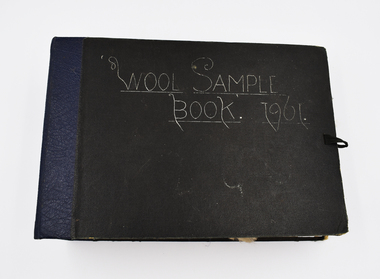 National Wool Museum
Book - Wool Sample, 1961
The donor, Brian Licence, assembled this Wool Sample Book while studying at the Gordon Institute from 1960-62. Brian studied Wool Classing and worked for a decade in this profession before moving to Melbourne which required him to change careers. The National Wool Museum accepted a donation from Brian in 2022 of several mementoes relating to his career in the wool industry. This wool sample book joins a collection of 8 others within the museum’s collection, with the oldest dating to 1870 at the time of writing in 2022. Large black bound book with ribbon for fastening containing 12 double-sided blue pages. Pages have several samples of shorn wool mounted and annotated to include information such as specific breeding, shearing faults, and geographical area. The book concludes with four pages without wool samples. Two of these pages relate to plans for a shearing shed and other industry related structures. The final two-pages relate to the anatomy of a sheep. Wool sample books were constructed by Wool Classing students at the Gordon Technical School as examples of what to look for when classing wool. The students were tasked with constructing these books with samples they retrieved themselves from several different farms and animals. The book would serve as a reference point for the wool classers throughout their years in the field, it was always on hand to refresh knowledge. This book was constructed by Brian Licence over his schooling at the Gordon between 1960 and 1962. Front Cover. Handwritten, White Ink "Wool Sample / Book. 1961”wool classing, gordon technical college, brian licence -
 Southern Sherbrooke Historical Society Inc.
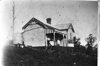
Photograph - Glen Park Homestead, Percy and Cissy Johns on verandah, early 1900s
B&W photo shows siblings Percy and Cissie (Minnie Agnes) Johns on the verandah of their home, Glen Park Farm, Selby. Percy looks in his early teens, making the photo around 1910 or later. He is wearing a long-sleeved pale shirt, long dark trousers tucked into knee-high boots, and possibly a dark hat. Cissie is wearing a pale, knee-length dress, dark stockings, and a pale, wide-brimmed hat. She is aged about 10. A medium sized dark dog sits at Percy's feet. The house is an L-shaped weatherboard with two gables at right-angles and a verandah with a bullnosed roof, ornate support posts, and a striped end piece from the roof. Wooden steps lead down from side. There is a large brick chimney where the two wings meet, and a metal water tank to the side. There are large trees, both in leaf and dead, plus some flowers near the verandah. -
 Kew Historical Society Inc
Plan - Subdivision Plan, Oswinia Estate, East Kew, c.1925
Prue Sanderson, in her groundbreaking ‘City of Kew Urban Conservation Study : Volume 2 - Development History’ (1988), summarised the periods of urban development and subdivisions of land in Kew. The periods that she identified included 1845-1880, 1880-1893, 1893-1921, 1921-1933, 1933-1943, and Post-War Development. These periods were selected as they represented periods of rapid growth or decline in urban development. An obvious starting point for Sanderson’s groupings involved population growth and the associated economic cycles. These cycles also highlighted urban expansion onto land that was predominantly rural, although in other cases it represented the decline and breakup of large estates. A number of the plans in the Kew Historical Society’s collection can also be found in other collections, such as those of the State Library of Victoria and the Boroondara Library Service. A number are however unique to the collection.Subdivision plans are historically important documents used as evidence of the growth of suburbs in Australia. They frequently provide information about when the land was sold on which a built structure was subsequently constructed as well as evidence relating to surveyors and real estate and financial agents. The numerous subdivision plans in the Kew Historical Society's collection represent working documents, ranging from the initial sketches made in planning a subdivision to printed plans on which auctioneers or agents listed the prices for which individual lots were sold. In a number of cases, the reverse of a subdivision plan in the collection includes a photograph of a house that was also for sale by the agent. These photographs provide significant heritage information relating house design and decoration, fencing and household gardens.The ‘Oswinia Estate’ subdivision in East Kew was planned and auctioned in the first half of the 1920s. 169 allotments were created in the triangular section of land bordered by High Street, Burke Road and the Government Boulevard (later Kilby Road). The only piece of land excluded was that where the previous Kew Pound had been located at the east tip of the triangle. Allotments were created fronting Glass, High, Namur, Oswin Streets, Irymple Avenue, and the Government Boulevard. The name for the Estate was derived from Oswin’s farm, which had been one of the largest landholdings in East Kew. The selling agents annotated the plan in our collection with crosses indicating those lots that had been sold. The inset locality plan is particularly interesting as it shows the route and stations of the Outer Circle Railway. When the subdivision plan was created, it included the proposed bridge over the Yarra at Burke Road. The bridge was to be officially opened in 1926.subdivision plans - east kew, oswinia estate, high street, glass street, namur street, government boulevard - kilby road, irymple street, oswin street -
 Kew Historical Society Inc
Plan - Subdivision Plan, Boulevard Estate - Boulevard Section, 1930-1936
Pru Sanderson, in her groundbreaking ‘City of Kew Urban Conservation Study : Volume 2 - Development History’ (1988), summarised the periods of urban development and subdivisions of land in Kew. The periods that she identified included 1845-1880, 1880-1893, 1893-1921, 1921-1933, 1933-1943, and Post-War Development. These periods were selected as they represented periods of rapid growth or decline in urban development. An obvious starting point for Sanderson’s groupings involved population growth and the associated economic cycles. These cycles also highlighted urban expansion onto land that was predominantly rural, although in other cases it represented the decline and breakup of large estates. A number of the plans in the Kew Historical Society’s collection can also be found in other collections, such as those of the State Library of Victoria and the Boroondara Library Service. A number are however unique to the collection.The Kew Historical Society collection includes almost 100 subdivision plans pertaining to suburbs of the City of Melbourne. Most of these are of Kew, Kew East or Studley Park, although a smaller number are plans of Camberwell, Deepdene, Balwyn and Hawthorn. It is believed that the majority of the plans were gifted to the Society by persons connected with the real estate firm - J. R. Mathers and McMillan, 136 Cotham Road, Kew. The Plans in the collection are rarely in pristine form, being working plans on which the agent would write notes and record lots sold and the prices of these. The subdivision plans are historically significant examples of the growth of urban Melbourne from the beginning of the 20th Century up until the 1980s. A number of the plans are double-sided and often include a photograph on the reverse. This plan shows a subdivision with two sections: the ‘Boulevard Section’ and the ‘Riverside Section’. The first of these sections bordered Burke Road between Kilby Road and the farm beside the Yarra. Kilby Road, Munro Road, Burke Road and Old Burke Road bordered the 102 lots in the Boulevard Section of the plan. The streets within the Section included Walbundry Avenue, Inverness Way, Riverside Avenue, Cascade Street and Kyora Parade. These street names, at least in this subdivision plan linked the two Sections of the subdivision. At a later date, the City of Kew decided to alter the street names. Walbundry, Inverness, Riverside, Cascade and Kyora were all renamed as ‘Drives’ (e.g. Kyora Drive). The subdivision plan is of interest in that it names High Street in Kew as Doncaster Road. It also shows the location of the wooden church that was later removed to Yarraville on the corner of Kilby Road and High Street. The plan predates later developments such as the S. E. Dickens Supermarket.subdivision plans - east kew, boulevard estate, munro road -- kew east (vic.), kilby road -- kew east (vic.), burke road -- kew east (vic.), walbundry avenue -- kew east (vic.), inverness way -- kew east (vic.), riverside avenue -- kew east (vic.), cascade drive -- kew east (vic.), nyora parade -- kew east (vic.) -
 Warrnambool and District Historical Society Inc.
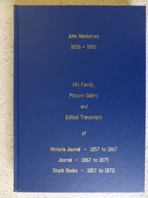
Book - Facsimile: John Mackersey 1826-1892, John Mackersey 1826-1892, 2014
John Mackersey farmed the property Kenilworth which is situated near Cavendish, 16 miles from Hamilton on the Wannon River. It was taken up by Thomas Norris in 1839 and originally carried 800 cattle and 20000 sheep on 63000 acres. By 1858 it was in the hands of John Mackersey and Thomas Bostock. In 1859 it belonged outright to John Mackersey who was there until 1870. He was considered a worthy son of a Presbyterian minister and was well regarded in the district for his contributions in church, sport and sheep breeding. However he did not do well and lost the property before going to New Zealand in 1870. This publication contains the typed transcripts of his journals, stock books.A significant collection of documentation of one of Western Victorian earliest settlers, depicting many aspects of life at that time.Dark blue hard cover with gold lettering on front cover and spine. It is a typed copy of the original handwritten journals. There are seven sections each separated by a title sheet of blue paper. Acknowledgements to The State Government of Victoria, State Library of Victoria, Hamilton History Centre, Dr G Handbury AO, Margaret Gardiner, Godfrey and Margaret Mackersey, L Alan Brumley, M P Heuval. john mackersey, kenilworth, thomas norris, thomas bostock, warrnambool history -
 Eltham District Historical Society Inc
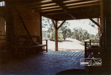
Photograph, The Jelbart Barn, 93 Arthur Street, Eltham, 1972c
Owned at the time by architect, Ian Jelbart, the property had been in the Jelbart family since the 1940s; a 5560sqm secluded hilltop parcel in Eltham. When the manor house and its barn were built, Eltham was a rural community; Jelbart’s grandfather Ronald was a businessman whose poultry farm formed part of the family’s original 100ha holding. A portion would later be subdivided into residential lots to make way for new homes that would form the basis of the Woodridge Estate in the early 1970s. The Barn was developed as a residence by Ian Jelbart in the late 1960;'s. Handmade mud bricks were used in its construction. This is a view from The Barn looking towards the Manor HouseDigital file only; created from scan undertaken by EDHSarthur street, eltham, houses, jelbart barn, jelbart property, kinloch gardens, verandah, mud bricks, enclosure -
![Photograph - Digital image, Bosch family [as adults], 1914c](/media/collectors/4f729f5697f83e03086015b8/items/5441bd572162f10c081ec065/item-media/5441bd9b2162f10c081ec218/item-fit-380x285.jpg) Greensborough Historical Society
Greensborough Historical SocietyPhotograph - Digital image, Bosch family [as adults], 1914c
Photograph of Bosch (Bush) family as adults. Left to right: John Adam Bush Senior (Johannes Adem Bosch born 19/8/1867 died1925), Frederick William Bush (31/3/1892-20/8/1952), John Adam Bush Junior (3/2/1895-24/6/1970), Amelia Suzanne Bush (b25/6/1893). Johannes Bosch came to Australia in 1884 aged 17. He married Henrietta Duck, had 3 children and divorced in 1903. Around 1902 he anglicized the family name to Bush.They farmed along the Plenty River having purchased land from Flintoff. Digital copy of black and white studio photograph.john adam bush, johannes adem bosch, frederick william bush, amelia suzanne bush, bosch family, bush family -
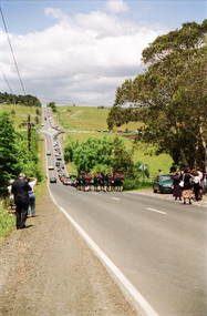
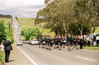
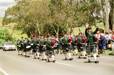
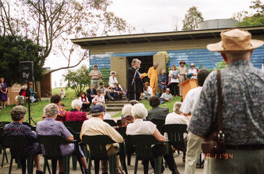
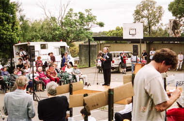
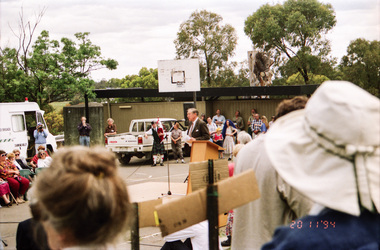
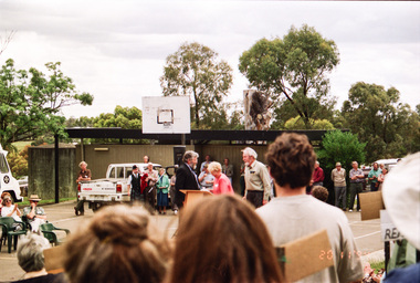
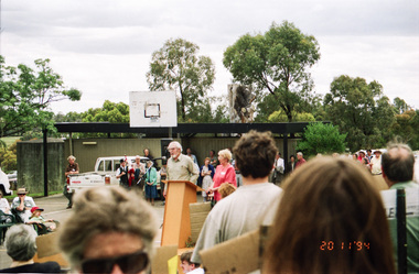
 Eltham District Historical Society Inc
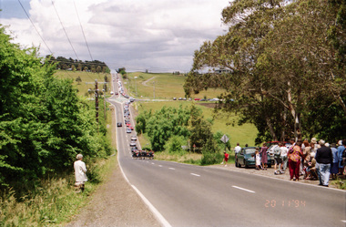
Photograph, Opening of Andrew Ross Museum, Kangaroo Ground, 20 Nov 1994, 20/11/1994
In 1992 Shire of Eltham Historical Society member and Kangaroo Ground resident, Bruce Ness became aware that the old school teacher residence at Kangaroo Ground School was no longer being used. Over the years Bruce had been storing a growing collection of the Society's artifacts and objects including various machinery and farm tools. He proposed that this might present an opportunity to set up a museum with the Society's objects. It was proposed that a board be appointed containing representatives of the Society, the School Council, Shire of Eltham and "Friends of the Andrew Ross Museum." As a consequence, most of the Society's objects were transferred to the museum and the Society became more focused on documents, maps and photographs, etc.Roll of 35mm colour negative film, 3 stripsFuji 100shire of eltham historical society -
 Eltham District Historical Society Inc
Photograph, Opening of Andrew Ross Museum, Kangaroo Ground, 20 Nov 1994, 20/11/1994
In 1992 Shire of Eltham Historical Society member and Kangaroo Ground resident, Bruce Ness became aware that the old school teacher residence at Kangaroo Ground School was no longer being used. Over the years Bruce had been storing a growing collection of the Society's artifacts and objects including various machinery and farm tools. He proposed that this might present an opportunity to set up a museum with the Society's objects. It was proposed that a board be appointed containing representatives of the Society, the School Council, Shire of Eltham and "Friends of the Andrew Ross Museum." As a consequence, most of the Society's objects were transferred to the museum and the Society became more focused on documents, maps and photographs, etc.Roll of 35mm colour negative film, 3 stripsFuji 100shire of eltham historical society