Showing 10730 items
matching sites
-
 Tatura Irrigation & Wartime Camps Museum
Leaflet, Local Places of Historical Interest, 1972
Recorded by Nagambie Historical Society. History of Kirwan's Bridge, Angustown, Aboriginal Camp ovens, Day's Mill, Oold pumping site, Goulburn WeirGold cover, black writing. Compiled September, 1972books, history, local -
 Tatura Irrigation & Wartime Camps Museum
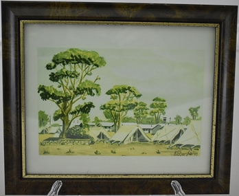
Artwork, other - sketch, POW Camp 13 - Tents, 1941
Water colour sketch by internee Klober at Camp13. Depicts tents used early 1941 before the galvanised iron huts were constructed on site.Laminated watercolour sketch of many tents with huts and large gum trees in the background. Brown frame with gold edgecamp art work, camp water colours, klober, camp 13, internment camp tents -
Tatura Irrigation & Wartime Camps Museum
Documents, Heritage Victoria, 06.09.2005
Letter in answer to a query as to status of Camp 13. Reports from Heritage Victoria describing Dhurringile Mansion and Camp 13 POW Camp site.Correspondence and reports. -
 Uniting Church Archives - Synod of Victoria
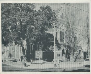
Photograph, undated c.1912 - 1920
The Malvern Congregational Church was built in 1886, replacing the original church built in 1873. The 1886 church was demolished in 1996. A Coles Supermarket was built on the site.B & W photograph of the Malvern Rd. Congregational Church located at the corner of Winter St. and Glenferrie Rd. malvern congregational church, sunday school, picnic -
Stawell Historical Society Inc
Map, Department of Lands & Survey J. Noone, Township of Heatherlie. Parish of Baroka. County of Borung 1888, 1888
Stawell & Grampians Freestone Quarry Company Railway Reserve. Cross & masons Quarry Site. Mamnager'sHouse, Stead's boarding House Stawell and Grampians railwaySurveyed Township Showing Quarry and railway Reservephoto Lithographed at the Department of lands and Survey Melbourne By J Noone 15.6.88railway quarry -
 Ballarat Heritage Services
Photograph - Photograph - Colour, Dorothy Wickham, Ballarat Female Refuge, 2000
Ballarat Female Refuge was established in 1867 by a group of 26 Ballarat ladies. It was moved to the present site in Scott's Parade in 1884. It is now a private residence.Postcard size colour photgraphs showing the interior and exterior of the Ballarat Female Refuge. ballarat femail refuge, welfare, town and city mission, alexandra babies home, baby, orphanage, sarah ellis -
 Sunbury Family History and Heritage Society Inc.
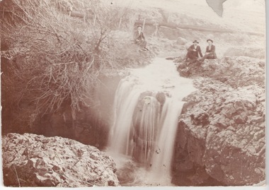
Photograph, c1910
The men are sitting above the waterfall and the Jacksons Creek close to the site of the former mill which utilised the water from the river to power the mill machinery.A sepia photograph mounted on cardboard of three men sitting on a river bank above a waterfall with a pipeline in the background.jacksons creek, sunbury -
 Stawell Historical Society Inc
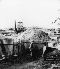
Photograph, Magdala cum Moonlight Mine looking from Walker Street
Magdala cum Moonlight Mine. Two boys in front of view of mullock heap and mine site with poppet head and smoke stacks in rear of photo.Mine and waste heap with two boys and fence in foregroundstawell gold mining -
![Book - Article, Fiona Weaver, Lower Plenty River Archaeological Survey by Fiona Weaver [excerpt], 1991](/media/collectors/62fc2e8d3b4c83fe7f279a1c/items/6450d73a49371722cf4f2ee8/item-media/6450d9b949371722cf4f5830/item-fit-380x285.jpg) Heidelberg Golf Club
Heidelberg Golf ClubBook - Article, Fiona Weaver, Lower Plenty River Archaeological Survey by Fiona Weaver [excerpt], 1991
Excerpt from Lower Plenty River Archaeological Survey by Fiona Weaver. Section 5 on Aboriginal archaeological sites in the Lower Plenty River area.A survey of First Nations sites in the Lower Plenty River area.Copy of part of book.lower plenty river, aboriginal sites -
 Sunbury Family History and Heritage Society Inc.
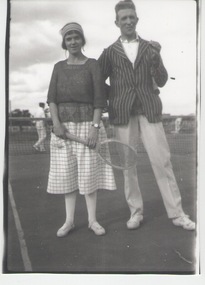
Photograph, c1920s
A couple on the first tennis courts to be built in Sunbury. They were situated behind the Post Office. A retail centre and bus terminal now occupies the site.A non-digital black and white photograph of a lady and man standing near a tennis court. The man is wearing a striped sports jacket and the lady is holding a tennis racket. People in the background are playing tennis.tennis, tennis courts, evans street -
 Linton and District Historical Society Inc
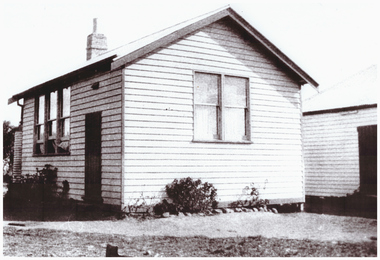
Photograph, Mannibadar State School Building
A school at Mannibadar opened in 1929, this building eventually became the supper room at the Mannibadar Hall. A "new" building was brought to the site from Canico in the 1930s.Copy of black and white photograph of the original Mannibadar State School building. Label on mounted photograph gives date "early 1930s".mannibadar state school, buildings -
 Sunbury Family History and Heritage Society Inc.
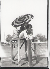
Photograph, C1920s
The tennis courts in the photograph were located in Evans Street in Sunbury on the site of the present day Shopping Square complex. They were used by the townspeople in the 1920s. The various sporting clubs generated much community spirit in Sunbury.A non-digital black and white copy of an old photograph of a lady and man sitting under a sun umbrella on a tennis referee's seat at a tennis court. Some people are visible in the background playing tennis. tennis, tennis courts. -
 Orbost & District Historical Society
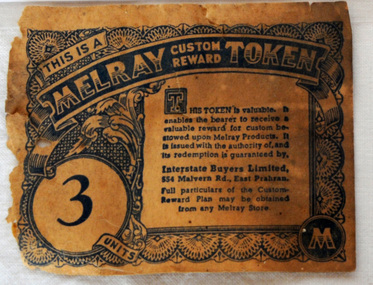
token, mid 20th century
" As well as preserving companies, various grocery chains, buying groups and wholesale co-operatives sold jam under their own brand names. One such company was Melray. Melray, founded in East Prahran, Melbourne, in 1932, was the forerunner of the Foodland chain (1958). It had branches across the country. Their jam labels included special reward tokens for redemption in-store. It is most likely that Melray jam was produced by Henry Jones’ Australasian Jam Company, or at least labelled at the iconic Jam Factory in South Yarra, Melbourne – a site of jam production in Australia for almost 100 years. Many Melray labels were discovered there, when the site was converted to a shopping centre in the 1970s, a period of industry-wide decline." (Information from australiapostcollectables web-site) The Melray Association of Independent Grocers consisted of the leading storekeepers throughout the State of Victoria, with a central headquarters and bulk store in Melbourne.These tokens were issued by Melray Stores as a reward for custom. This item is associated with the period when Australia produced and exported much more of its agricultural produce - including tinned jam.A paper token - Melray Custom Reward Token. This is a reward token issued by Melray for regular custom - 3 units.melray grocery-store custom commerce -
 St Kilda Historical Society
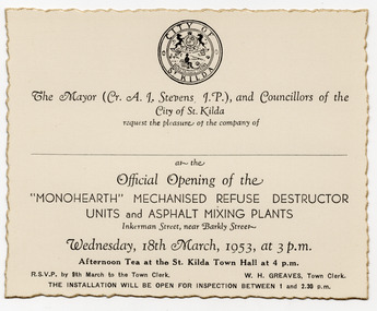
Ephemera - Invitation, Official Opening of the 'Monohearth' Mechanised Refuse Destructo Units and Ashphalt Mixing Plants, 1953
Invitation to the official opening of refuse destructor units and asphalt mixing plants at Inkerman Street, St Kilda, on 18 March 1953. The destructor units replaced a garbage incinerator that had been operating at the site for thirty years and had become obsolete. They were expected to serve St. Kilda's requirements for the next 80-100 years. In 1994, as a result of the local government amalgamation process combining the former Cities of Port Melbourne, South Melbourne and St Kilda, the new City of Port Phillip owned three municipal depots. The St Kilda municipal depot site became surplus to requirements and, in 1996, the City of Port Phillip resolved to use the site for a community housing project under the City of Port Phillip Housing Program. White card printed in black, with gold jagged edges. Shows St Kilda logo.monohearth, st kilda municipal depot -
 Bendigo Historical Society Inc.
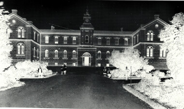
Document - Bendigo Base Hospital, 1853-1970s
The hospital was first mooted in 1853. The first site chosen was "Hospital Hill" between Rowan and Mackenzie Streets and behind the present Lister House School of Nursing. The first building was a primitive affair of slab and weatherboard daubed with clay somewhere near the middle of the present Short St - which at the time extended to the brow of the hill behind the Sacred Heart Cathedral site. The new building was greatly need to serve the hundreds of diggers then active on the field. Messrs Vahland and Gezchmann, Architects, designed a new building of stone and brick, the cenre portion of the hospital to hold 100 beds. This centre portion cost 12,000 pounds and was erected in three months. Patients were transferred from the old site on Hospital Hill to the new building in December 1858.Black and White photo negative of the front of the hospital; Notes on the History of "The Bendigo Gold District Hospital"; letters re classification by the National Trust of Australia (Victoria).history, national trust bendigo collection, bendigo, bendigo base hospital, bnedigo hospital, bnedigo gold district hospital -
 Ringwood and District Historical Society
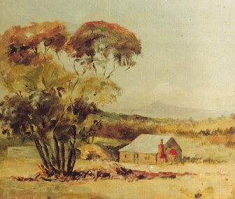
Photograph, Painting by Mrs. Miles of the first mine manager's cottage at mine site, East Ringwood. (No record of date)
Catalogue card reads, "Print of oil painting done by Mrs. Miles of first miners cottage used for mine manager". Written on back of picture, "Painting by Mrs. Miles of the first mine manager's cottage at mine site, East Ringwood. He was relative of Edith Gluth who lent the painting for photo copying". -
 Ringwood and District Historical Society
Photograph, Ringwood Post Office in 1908/9. Maroondah Highway
Typed below one copy, "Ringwood Post Office in 1909. Maroondah Highway - Opposite present Holeproof site". Other copy of same photograph reads, "Ringwood original Post Office opposite Guyatts new store - 1908". Backing sheet states, "Ringwood P.O. Weekly Times 4 July 1908". -
 Kew Historical Society Inc
Postcard, Victoria Street Bridge, Collingwood, 1905-1913
Victoria Bridge is a riveted and welded steel Warren truss bridge over the Yarra River completed in 1884 to a design by Fraser & Chase following a controversial design competition held in 1880. Funds for the bridge's construction were provided by the councils of Collingwood, Hawthorn, Kew and Richmond. The contract was awarded to Mr P. Platt. Charles Rowand was officially appointed Supervising Engineer in 1883. The winning design was based on the theoretical work of William Charles Kernot (1845-1909) who campaigned for economy in public works design and the application of scientific principles in engineering. ... The bridge was widened in 1890 by the addition of a third line of truss on new piers on the up stream side to carry horse trams. Work commenced in 1914 to convert the horse tramway to an electric tramway by the Prahran & Malvern Tramways Trust, part of the Trust's extension of its tramway into the eastern suburbs between 1913-18. In 1915 the bridge was further strengthened to accommodate the extra weight of electric trams and widened by the addition of two six feet cantilever footpaths. During this period the Prahran & Malvern Tramways Trust erected two ornamental gantries over the roadway to support overhead wires for the electric tramway. Further widening and reconditioning of the bridge took place in 1933, including the addition of four new welded trusses, two intermediate and two on the outside. The latter were supported on new cantilevered truss cross beams attached to the top of the piers. (Source: Heritage Victoria)Early and rare postcard of the Victoria Street Bridge linking Victoria Street and Barkers Road.Polychrome postcard of the Victoria Street Bridge which links Richmond and Abbotsford with Kew and Hawthorn.View from Harrison Cres embankment / former Xavier College boatshed on site of tree in foreground. / Chimney left corner - Wool Scoring Mils in Victoria St. / On horizon - Studley Villa, Studley House circa 1880s, Studley Hall / Chinese gardens to be seen behind three set of columns / M.J. Slatterypostcards -- yarra river, postcards -- bridges. -- greater melbourne (vic.), victoria street bridge -
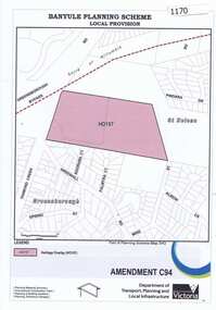 Greensborough Historical Society
Map, Saxam Heritage Overlay, 2011_
"Saxam" was the home of the Kaye family (1886-1888) then William Santon, a former councillor and Mayor of Heidelberg. Saxam Homestead is a distinctive and substantial timber homestead built in the late 1880s as one of the notable rural properties in the St Helena area. In 2014 the house still stands but is in poor condition with most interior features removed. The site had a heritage overlay as shown. The overlay was reduced in 2014 to protect the house while allowing residential development on the site.Saxam is one of the only remaining farmhouses in the Greensborough area.Copy of map and planning scheme.saxam -
 Kiewa Valley Historical Society
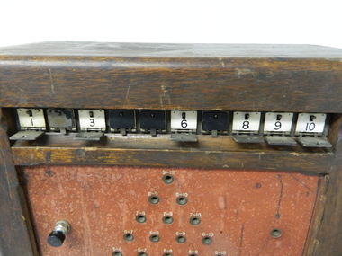
Console Telephone 10 shutter, circa early 1900s
This manual telephone exchange console is an important piece of equipment which provided the most efficient method of long distance communications in the 1950's to the 1980's. Communications were critical, not only for the regional Hospital, but also for large construction sites i.e. the Kiewa Hydro Scheme, especially if they are in dense rugged mountainous regions. The degree of Occupation Health and Welfare on industrial sites were at a bare minimum compared to the work scene after the 1980's.This telephone exchange console is highly significant to both the Kiewa Valley and Mount Beauty region because it was so important in the communications field relating to operational safety and work related controls. The success of any large undertaken relies heavily upon good communications. In the hospital this method of communications is still used i.e. patient to ward station. This flag system link a patient's room to the controlling nursing station. Identification of the patient needing help is crucial for swift action from the available medical staff. Similarly in large construction sites such as the Kiewa Hydro Scheme, successful instant communications was also essential. This switchboard required a 50 volt supply to successfully operate and was in use when both telecommunications and postal were under the one Federal Government carrier i.e. The Post Master General. A benefit with a line communication system (such as the one that fed this console was that interference from atmospheric conditions did not impede the connection.This console telephone switchboard (manual) unit has a shutter operation (precursor to the light indicator) to identify the caller to the telephone switchboard operator. This switchboard has a ten point indication shutter system allowing the operator to clearly identify where the caller is located. The console has a 44 connection point holes with their configurations in a triangular shape. The shutters are held closed by a small lever at the top which is opened by a small electrical charge from the incoming call. The operator uses a wind up handle to power a magneto connector(handle on the console's right side). The telephone hand set is located on the left side of the console. sec vic kiewa hydro scheme, alternate energy supplies, alpine population growth and communications -
 Federation University Historical Collection
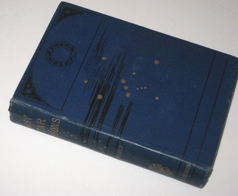
Book, Richard A. Proctor, Easy Star Lessons, 1881
In 1873 Teesdale residents formed an institute to provide literature to improve the minds. The site was gazetted on 25 October 1875 – a one acre site on the corner of Bridge Street and Mercer Terrace. A Mechanics Institute was built and later a supper hall was added in front of the institute. The mechanics institute and supper hall was destroyed by fire on the night of 29 March 1969. (http://linkingtowns.com/index.php?option=com_content&view=article&id=91&Itemid=252) Blue hard covered book of 239 pages. Many illustrations f constellations during each month. Inside front page 'Mechanics Institute Teesdale No 270'astronomy, library, teesdale, mechanics institute -
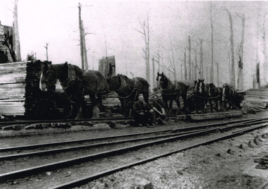 Otway Districts Historical Society
Photograph, Brucker, Pile Siding: horse-drawn timber tram, c.1920, c.1920
Pile Siding was opened in December 1915 because of the Pettit Brothers sawmill and pile extraction operation. The siding was a spur with points facing Beech Forest with a timber tramway feeding the siding. During 1916/17 Pettit's sent away 5,000 tonnes of timber before moving to another site, after which loading dropped to insignificant proportions. Pettit's again occupied the site from 1924 and traffic rose to major levels again.B/W. A six horse-drawn timber tram at Pile Siding station in c.1920. Two timber workers are seated at the centre. Stacks of timber are awaiting collection. Note the bare tree trunks in the background. pile siding; weeaproinah; railways; tramways; -
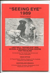 Vision Australia
Administrative record - Text, "Seeing Eye" 1989 Lady Nell "Seeing Eye" Dog School & Rehabilitation Centre for the Blind, 1989
President's overview of defamatory media and government investigation of the school, reopening of the hostel at 2 Derril Avenue, Malvern, difficulty in obtaining pups, difficulties in not being able to expand at Thanet Street site and inability to use the Dingley site as intended due to the proposed freeway, inability to fundraise due to bad publicity, court action against Herald-Sun journalists, discussion over cases where dogs were removed and profiles of some people and their dogs. 1 volume with text and illustrationsannual reports, lady nell seeing eye dog school, phyllis gration -
![Sign, Regulations for the Care, Protection and Management of the " Penguin Reserve" at Phillip Island [ As amended ] 1956 and 1968, 1956 and 1968](/media/collectors/4f729f5b97f83e0308601629/items/6476aa1f1e1a2671cef44090/item-media/6476ab3b1e1a2671cef4be40/item-fit-380x285.jpg) Phillip Island and District Historical Society Inc.
Phillip Island and District Historical Society Inc.Sign, Regulations for the Care, Protection and Management of the " Penguin Reserve" at Phillip Island [ As amended ] 1956 and 1968, 1956 and 1968
Board of Land and Works reserved land on Phillip Island by Orders in Council in December 1955 and June 1956 as sites for a penguin rookery and known as the Penguin Reserve.HistoricalLarge cream cloth sign with black print outlining regulationswildlife - penguins, penguin reserve, phillip island nature park, signs -
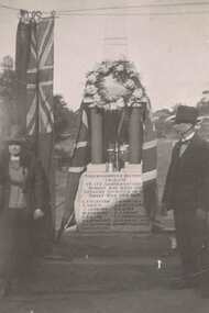 Greensborough Historical Society
Photograph - Digital image, Fallen Soldier's Memorial Greensborough, 1923c
These photographs shows the World War I "Fallen Soldiers" Memorial at it's original site in Main Street Greensborough. Photographs appear to be taken early 1920s.The Memorial has been moved several times and is now situated the War Memorial Park in Henry Street Greensborough.Digital image of 2 black and white photographs.greensborough war memorial park, fallen soldiers memorial greensborough -
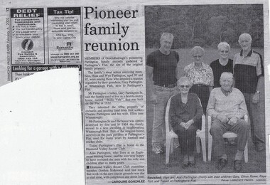 Greensborough Historical Society
Newspaper Clipping (copy), Diamond Valley Leader, Pioneer family reunion, by Caroline Gonzalez, 6/02/2002
Reunion of Alan & Wyn Partington, with their children, Gary, Elinor Rowe, Faye Fort and Trevor at Partington's Flat, site of their original family home, Willis Vale.The family are the descendants of the original settlers, Charles and Ellen Partington.Photocopy of article published in Diamond Valley Leader 6 February 2002, text and photographpartington family, partington's flat, willis vale -
 Greensborough Historical Society
Newspaper Clipping, Diamond Valley Leader, Uni offers to sell Strathallan Golf Course land, 30/08/2017
La Trobe University has offered to sell the Strathallan Golf Course land to Darebin Council after years of speculation over the future of the Bundoora site.News article 1 page, black text, colour image.la trobe university, strathallan golf course, darebin council -
 Greensborough Historical Society
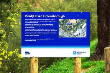
Photograph - Digital image, Marilyn Smith, Plenty River bank stabilisation 2015, 16/08/2015
River bank stabilisation project along the Plenty River at Greensborough 2015, conducted by Melbourne Water. Project sign and close-up of aerial view of site.Digital copy of colour photographplenty river, melbourne water -
 Greensborough Historical Society
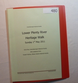
Folder, Lower Plenty River Heritage Walk 2011, 01/05/2011
Contains information about the sites visited on the Heritage Walk 2011 through Yallambie and Viewbank. Notes compiled by Anne Paul with assistance from Russell Yeoman.20-page plastic binder, redcover. Contains 12 page guide.plenty river, heritage trail, anne paul, greensborough historical society, yallambie, viewbank, russell yeoman -
 Halls Gap & Grampians Historical Society
Photograph - B/W
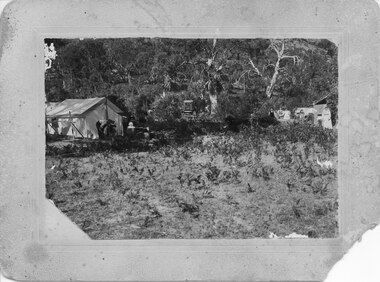
This is a photo of a camps site at the base of Mackeys Peak. The Willoughby's are camped on the left, The Barnes in the centre and the Hines on the right (presumably the people in the photo are from these family groups).The photo shows tents in a clearing in bush.There is a large tent to the right with a man and a young child in front of it, another tent or structure can be seen on the left with a group of four adults and two children lined up in front of it. A buggy can be seen in the bush in the centre.Camp at base of Mackey's peak, Willoughby's camp, Barnes Camp Hines Camp, written in pen on back of mount.recreation, camping, scenery, grampians ranges