Showing 10968 items matching " plan."
-
 University of Melbourne, Burnley Campus Archives
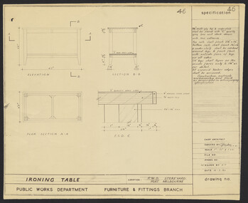
Plan, Specification for Ironing Table, 1960
Plan for P.W.D. Storeyard, Port Melbourne. No. 46 by Public Works Dept., Furniture & Fitting Branch. Redrawn by K.H.storeyard, port melbourne -
 University of Melbourne, Burnley Campus Archives
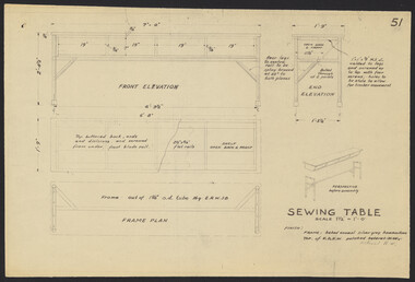
Plan, Sewing Tables, 1958
Plans. A. Sewing Table No. 51 B. Table for Electric Sewing Machines by Chief Architect, Public Works Dept.sewing, tables, machines -
 University of Melbourne, Burnley Campus Archives
Plan, Bolobek, c. 1970
Photocopy of p 47 from book (unknown) showing Garden Plan, tracing paper and reduced size copy. 'Bolobek' handwritten on revese of photocopy.bolobek, gardens, landscape design -
University of Melbourne, Burnley Campus Archives
Booklet, Braeside Metropolitan Park, 1985-1987
parks, hon a mccutcheon -
Canterbury History Group
Ephemera - "Terrappee" 26 Balwyn Road Canterbury, 1995
Real Estate advertisement for "Terrappee" 26 Balwyn Road Canterbury. includes interior and exterior photographs and floor plancanterbury, balwyn road, terrappee, coghill cleary first national -
Canterbury History Group
Ephemera - "Loch Ard" 24 Faversham Road Canterbury, 1996
Real Estate Advertisement for sale of "Loch Ard" 24 Faversham Road Canterbury. includes sketch of the house and planscanterbury, loch ard, faversham road, sinclair & co -
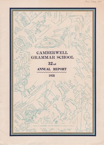 Camberwell Historical Society
Booklet (Item), Camberwell Grammar School, Camberwell Grammar School 32nd Annual Report 1958, 1958
camberwell, school -
Camberwell Historical Society
Document (Item) - Report, City of Boroondara, City of Boroondara Annual Report 1998/1999, 1999
boroondara -
Camberwell Historical Society
Document (Item) - Report, City of Boroondara, City of Boroondara Annual Report 2000, 2000
boroondara -
Bendigo Historical Society Inc.
Map - BENDIGO PARISH PLAN
BHS CollectionBendigo Parish Plan Central Bendigo. Canvas with Canvas typed edges. Taken from George Black's maps -
 Lakes Entrance Historical Society
Photograph, Jemmeson, Edie, 1928
The fully self contained camp park containing accommodation, general store, entertainment rotunda, petrol bowsers and community kitchen was the vision of Richard Bromby Whiter who commenced the project in 1927. Water for gardening and sewerage supplied by an underground bore.Black and white photograph of the entrance to the planned Lakes Camping Park, fronting Roadknight Street, Lakes Entrance, Victoria.tourism, recreation, caravan parks -
Port Melbourne Historical & Preservation Society
Plan - New port workers dining room and alterations, Station Pier, Port Melbourne, Godfrey, Spowers, Hughes, Mewton & Lobb, Feb 1956
Plan new port workers dining room and alterations and additions to existing offices and stores at Station Pier, 1956melbourne harbor trust - port of melbourne authority -
 Buninyong Visitor Information Centre
Document (Item) - Information Folder, Buninyong Mechanics Institute and Free Library
Copies of images showing the development of and changes to the library building.buninyong mechanics institute, buninyong library, buninyong -
Glenelg Shire Council Cultural Collection
Plan - Plans / Line Drawings - Port of Portland Floor Plan layout and footings Marine Department depot, Victoria, n.d
PORT OF PORTLAND AUTHORITYFront: '6' black texta, top right corner -
University of Melbourne, Burnley Campus Archives
Book - Report, E.B. Littlejohn, Victoria 1944 State Regional Boundaries Committee Report on Regional Boundaries, 1944
See paper catalogue for complete contents. Item formerly property of E.B. LittlejohnReport includes maps of Regions for Planning and Development, geographical, weather, power, water resources, crops, livestock, etc.e.b. littlejohn, planning, development, regions -
University of Melbourne, Burnley Campus Archives
Plan, Melbourne Girls College, 1980s?
Coloured, laminated, Concept Plan for Courtyard between Portables and East Elevation Main Building. Scale 1:100. Student: Redna Moore, on reverse.melbourne girls college, redna moore, students, courtyard -
University of Melbourne, Burnley Campus Archives
Plan, Gerner Sanderson Faggetter Cheesman, Hay's Paddock, 1981
Sketch Plan dated September 1981, by Gerner Sanderson Faggetter Cheesman, Drawing No 200.01. Scale 1:100.gerner sanderson faggetter cheesman, hay's paddock, kew, parks -
 Bendigo Historical Society Inc.
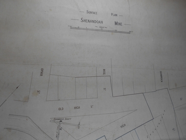
Administrative record - Shenandoah Mine Surface plan
Draftsman's drawing Shenandoah Mine Surface Plan Map. Forms part of the Margaret Roberts Collection of mining records.bendigo, margaret roberts, gold, map, mine, shendandoah mine -
 Lakes Entrance Historical Society
Photograph - Tambo Shire Staff, Lakes Post Newspaper, 1995
Black and White Photograph of Helen Martin Director of Strategig Planning and Dev. 1995 Tambo Shire Gippsland Victoriamuincipal history -
 Lakes Entrance Historical Society
Photograph - Tambo Shire Staff, Lakes Post Newspaper, 1996
Black and White Photograph of Helen Martin Director of Strategig Planning and Dev. 1995 Tambo Shire Gippsland Victoriamuincipal history -
Lakes Entrance Historical Society
Book, LERHS, Background to Entrance Construction, 1989|2013
Containing background information about the planning construction and opening of the artificial entrance from the ocean to the Gippsland Lakes Victoriawaterways, civil engineering, topography -
 Ringwood and District Historical Society
Document - Map, Part of Crown Allotment 27C, Parish of Warrandyte, County of Evelyn, Ringwood, Victoria - c.1970
Photocopy of subdivision plan 75131 Vol 3439 Fol 712 showing numbered residential allotments with property dimensions.Surveyors and Consulting Engineers - O'Connor & Beveridge, Main Eltham Road, Lower Plenty, Tel. 432668. Rubber-stamped "Photocopy - Titles Office Complied 17 Feb 1970". Map includes Lockhart Road, Lansell Close, Terrara Place, Goldsmith Avenue, Park Hill Drive, Hilldale Close, and Elm Court, Ringwood, Victoria. -
Clunes Museum
Plan, CLUNES WATER SUPPLY
DRAWINGS MADE TO SET UP A PERMENT PIPED WATER SUPPLY TO NEW NORTH MINE, CLUNES, VICTORIA, AUSTRALIA1 PAGE PLAN WITH DRAWING OF CLUNES WATER SUPPLY ON WAXED PAPER USING RED, BLACK AND BLUE INKCLUNES WATER SUPPLY LONGITUDINAL SECTION OF CENTRE LINE OF THE LOWER AWUEDECT FROM WEIR A TO SERVICE RESERVOIR DRAWING 420 5 CONTRACT NO. 740 2 HORIZONTAL SCALE FOUR CHAINS TO AN INCH VERTICAL SCALE FORTY FEED TO AN INCH SIGNED BY OCTAVIUS LANGTREE WORKS ENGINEER 13/12/1870octavius langtree, peter lalor, clunes water supply -
 Warrnambool and District Historical Society Inc.
Letter book 15, 1920s
This letter book contains letters, sketch maps and plans and dates from 1929 to 1934. It came from the office of John William Crawley Junior, an engineer, surveyor, and architect in private practice in Warrnambool and also the engineer for the Shire of Warrnambool from 1895 to 1935. His father, brother and son were also engineers, working in that capacity or as Shire Secretary for the Shire of Warrnambool, with the Crawley family recording a total of 132 years of service to the Shire. The Shire of Warrnambool existed from 1863 to 1994. The letter book was passed on to John Crawley’s son, Rolf who was the engineer for the Shire of Warrnambool from 1935 to 1968. It then came into the possession of Michael Hand who took over the private surveying business of Rolf Crawley in Warrnambool. The Warrnambool and District Historical Society acquired the letter book, along with several other Crawley ledgers, from the estate of Michael Hand. This letter book is of considerable importance as it contains letters and maps from the late 1920s and 1930s and was compiled by John Crawley Junior, an engineer in the Shire of Warrnambool for 40 years. It will be a useful research tool. This is a hard-cover letter book of 1005 pages. It contains an alphabetical index at the front, handwritten letters, sketch maps and plans and some loose sheets. It has brown leather binding on the corners of the cover and on the spine but the spine covering is completely detached. The gold lettering on the spine is now almost completely obliterated. The cover is scuffed and torn. ‘Private Book’ ‘1929 to 1934’ john william crawley junior, warrnambool, rolf crawley, warrnambool, shire of warrnambool -
 Bacchus Marsh & District Historical Society
Map, Bacchus Marsh Township and Nearby Districts Maps Volume
This volume of maps is believed to have been compiled by staff at the Shire of Bacchus Marsh and was presumably used to inform and assist Shire staff and Councillors in the carriage of their duties.This collection of maps are significant due to their rarity as many of them are unique maps made for local purposes in the Bacchus Marsh region. They are also of strong research value containing a wide variety of information including landholders, land sales, infrastructure, such as roads, bridges, public, commercial and private buildings, houses, land use, and geographic features over multiple decades from the late nineteen century into the middle part of the twentieth century.One bound volume of maps comprising cadastral maps, (indicating property owners and land boundaries), land plans and real estate auction plans and advertising material, and other maps indicating major infrastructure like proposed roads and irrigation areas. Most of the maps and plans are of Bacchus Marsh and nearby areas but some maps are of nearby towns such as Melton, Ballan and Blackwood. The volume comprises 52 pages. Most pages have a single map or plan pasted onto it but some contain 2 or 3 different maps. There are 81 maps in total. Map 1 Liquidators Sale 1896. Map 2. Woodside Estate Sale 1913. maps, maps bacchus marsh, maps bacchus marsh region -
 University of Melbourne, Burnley Campus Archives
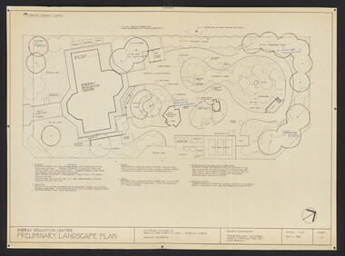
Plan, Steve Mullany, Energy Education Centre, 1988
(1) Tracing paper and paper plans, Preliminary Landscape Plan by Steve Mullany, Lecturer Amenity Horticulture Dept. V.C.A.H. Burnley, Sheet 1 of 1 May 2, 1988. (2) 1 tracing paper and 2 paper copies State Schools' Nursery: Proposed Landscape Working Drawing Energy Education Centre Burnley by E.A.H. June 1988. (3) 2 copies State Schools' Nursery: Proposed Landscape Working Drawing Energy Education Centre Burnley, by EAH 18 June 1988 (Details). (4) 2 copies as (3) Pond Plans & Details 16 June 1988. (5.) Designs for small plans of above.vcah, steve mullany, state schools nursery, landscape design, energy education centre burnley -
Bendigo Historical Society Inc.
Document - Sir John Quick Committee Minutes, Michele Matthews Collection
The Sir John Quick Committee was formed in 1991 to commemorate the achievements of Sir John Quick who played a prominent role in the federation of Australia. The Committee aimed to raise awareness of the contribution of Sir John Quick and to ensure that he was recognized for the part he played.1. Agenda and minutes of meeting of the Sir John Quick Committee held on 22.11.1994. Three typed pages. Items discussed Success of the inaugural Sir John Quick lecture at La Trobe University Bendigo. Plans to begin for 1995 Lecture. Formation of a Federation Centenary Committee set up by the Council. Sir John Quick Committee to be invited to participate in plans made by this Committee. Peter Tangey nominated to be representative on the Committee. 2. Minutes of meeting of the Federation Centenary Committee held on 29.11.1994. Two typed pages. Items discussed Aim to playing a role in planning local celebrations and bring a national focus on Bendigo. Distribution of Federal reports and planning suggestions.centenary of federation, federation centenary committee -
 Ringwood and District Historical Society
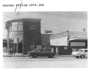
Document, Certificate of Title and miscellaneous property records - Carter Real Estate, 122 and 124-128 Maroondah Highway, Ringwood, Victoria
Transfer of Land Act Title dated 24/4/2002 - Volume 10314 Folio 972 Crown Allotments 11H and 11J, Parish of Ringwood, Entitlement Grant to a depth of fifteen metres - 29/1/1997, City of Ringwood planning permit and diagram of office floor plan - 1973. -
Bendigo Historical Society Inc.
Map - CAMPBELL COLLECTION: BENDIGO AND DISTRICT MAPS
Map. Whirrakee, Parish of Whirrakee. Total area of map 4419 acres. Scale 20 chains to 1 inch. 23 allotments are sold, Eucalypt oil distillery on lower portion of map. Prepared in W.P.B. from Assessor's plan and Parish Plan. (number 350 in map cupboard 1)map, bendigo, allotments -
Whitehorse Historical Society Inc.
Article, Say no to pokies: shoppers alarm, 1992
Residents will fight plans to develop a tavern with 90 poker machines in Forest Hill Chase Shopping Centre.Residents will fight plans to develop a tavern with 90 poker machines in Forest Hill Chase Shopping Centre. Nunawading Council's strategic planning department's spokesman, Richard Schuster, said the 3rd level at the Centre has developed into an entertainment level. The matter has not gone before Council at this stage.Residents will fight plans to develop a tavern with 90 poker machines in Forest Hill Chase Shopping Centre.shopping centres, forest hill chase, city of nunawading, schuster, richard