Showing 23748 items
matching sardine-creek
-
 Whitehorse Historical Society Inc.
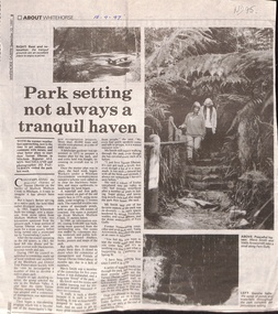
Newspaper - Article, Park setting not always a tranquil haven, 1/09/1997
Short history of Yarran Dheran on the banks of Mullum Mullum Creek in Mitcham, including mention of Schwerkolt Cottage, now a museum, and an Information Centre which now stands empty.schwerkolt cottage, smith, mavis, arrowsmith, valda, yarran dheran, parks and reserves -
 Lakes Entrance Regional Historical Society (operating as Lakes Entrance History Centre & Museum)
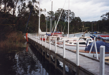
Photograph, 1999
Site occupied by Chinese fishermen and gardeners late 1800's and early 1900's.Colour photograph of the jetty at Chinaman's Creek showing yachts and launches moored on lake side of jetty, moored yachts visible in distance under timbered bank. Metung Victoriahouses, heritage study -
 Mt Dandenong & District Historical Society Inc.
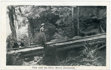
Photograph, View near the Falls, Mount Dandenong, early 1900s
Postcard showing a woman wearing a long dress and wide brimmed hat standing on a footbridge that crosses the Olinda Creek. Tree ferns and bushes are in the background. Taken early 1900s.On front of postcard: View near the Falls, Mount Dandenong. On back of post card: Mason, Firth & McCutcheon, Printers, Melbourne.mason, firth & mccutcheon, olinda falls, footbridge, bridge, mt dandenong, olinda creek -
 8th/13th Victorian Mounted Rifles Regimental Collection
Photograph - Training Puckapunyal
The 8th/13th Victorian Mounted Rifles was raised as a regiment of the Royal Australian Armoured Corps on 1 May 1948 with Headquarters in Melbourne and squadrons in Sale, Benalla/Wangaratta and Albury. In 1955 Regimental Headquarters moved to Wangaratta and a second squadron was located at Albury. The Sale squadron transferred to 4th/19th Prince of Wales’s Light Horse. In 1977 8/13 VMR Regiment was reduced to an independent squadron A Squadron 8th/13th Victorian Mounted Rifles and in 1991 was linked with 4th/19th Prince of Wales’s Light Horse forming the VMR Squadron of that regiment.Colour photograph of two M113 Light Reconnainance Vehicles (LAV) of A Squadron 8/13 Victorian Mounted Rifles crossing a creek during training at Puckapunyal, c.1987.lrv, puckapunyal, training, vmr -
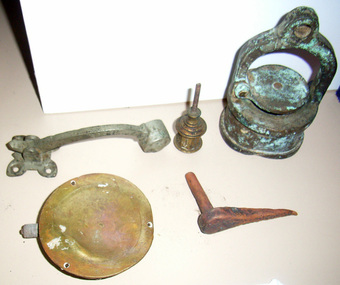 Queenscliffe Maritime Museum
Victoria Tower Relics, mid 1860's
"Victoria Tower" 3-mast ship wrecked 17th October 1869 on maiden voyage, Bream Creek near Torquay Victoria. 20 items mostly brass items -
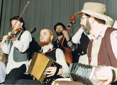 Bendigo Historical Society Inc.
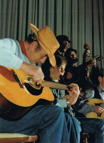
Photograph - PETER ELLIS COLLECTION: BUSH BAND
Colour photograph. Bush band. Violin. Accordion. Concertina. Back of photo reads Emu Creek. Photo has been in an album an still has some residue on rear.photo, group, musicians -
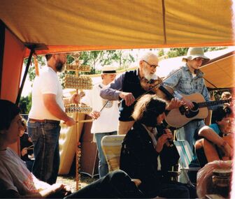 Bendigo Historical Society Inc.
Photograph - PETER ELLIS COLLECTION: EMU CREEK BUSH BAND
Colour photograph. Right side of photo is over exposed. End of film. Emu Creek Bush Band. Violin. Recorder. Guitar. Back of photo reads: A X Xphoto, group, musicians -
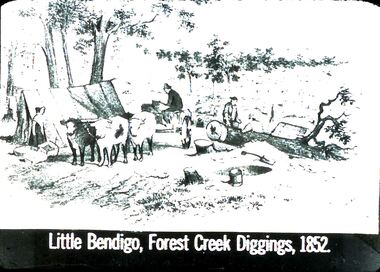 Bendigo Historical Society Inc.
Slide - DIGGERS & MINING: THE DIGGINGS - THE DIGGERS
Diggers & Mining: The Digging - The Diggers. Slide depicts areas of Little Bendigo, Forest Creek Diggings, 1852. Markings: 14 994.LIF:6. Used as a teaching aid.hanimounteducation, tertiary, goldfields -
 Bendigo Historical Society Inc.
Photograph - PETER ELLIS COLLECTION: BAND PLAYING
Colour photograph. Side view of band members. Man playing guitar. Young man on recorder. Lute. Back of photo reads: 2 Dean Swift Emu Creekentertainment, music, emu creek bush band -
 Bendigo Historical Society Inc.
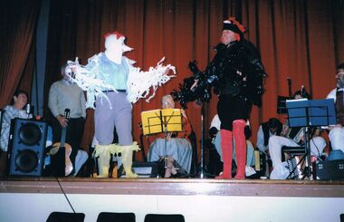
Photograph - PETER ELLIS COLLECTION: EMU CREEK BUSH BAND
Colour photograph. Two birdmen on stage. One man dressed as white bird, one man dressed as black bird. Emu Creek Bush Band. Red curtain.entertainment, theatre, people in costume -
 Bendigo Historical Society Inc.
Document - COLIBAN WATER - BENDIGO CREEK SEWER AUGMANTATION FUNCTIONAL DESIGN
Design for Coliban Water proposed new sewer. Bendigo creek sewer augmentation functional design dated 29/08/2003. Also eight aerial photos of the area.bendigo, business, coliban water -
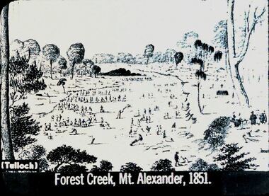 Bendigo Historical Society Inc.
Slide - DIGGERS & MINING: THE DIGGINGS - THE DIGGERS
Diggers & Mining: The Digging - The Diggers. Slide shows: Forest Creek, Mt. Alexander, 1851. Miners on the field. Markings:5 994.LIF:6. Used as a teaching aid.hanimounteducation, tertiary, goldfields -
 Falls Creek Historical Society
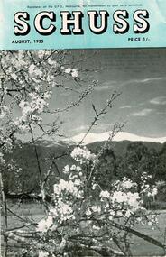
Journal - Schuss Vol. 21. No. 6 August 1955
Schuss was advertised as Victoria’s Official Ski Journal It was issued monthly from 1935 to 1961 except during the war when summer issues covered two months. This continued after the war, but it averaged 10 issues annually over its 25 year life. Schuss was published by the Ski Club of Victoria which had a membership of 38 Ski Clubs and demanded to be recognised as the prime authority on skiing in the state. The other 30 ski clubs with 85% of the members disagreed and the politics of skiing became heated. These clubs formed the Federation of Victorian Ski Clubs with their own journal, Ski Horizon. With the establishment of the Victorian Ski Association, Ski-Horizon published its last issue in Nov - Dec. 1955 and the role of the official journal was fully taken over by “Schuss”. This item is significant because it contains stories, images and information documenting the development of the ski industry in Victoria.The journal features stories and events chronicling developments in Victoria and internationally. Items related to the Falls Creek Area in this issue include:- Page 196 - A report on the Victorian Championships held at Falls Creek on 14 August 1955. Page 201 - SKYLINE Lodge of Falls Creek carried about eight feet of snow on its roof after the big August fall. As this consolidated more was added, till there was some 15 to 20 tons of packed snow on the roof. It also caused some damage which will require repairs in the spring; assistance from members is required in this work. This unusual depth of snow ensures skiing on the slopes above Skyline till well into the summer months. schuss journal, victorian championships 1955, skyline lodge -
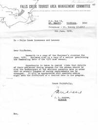 Falls Creek Historical Society
Document - Chairman's Circular June 1970 & Notice Proclaiming 1970 Snow Season Commencing Date, 08.06.1968
Bob (Herman) Hymans (a former member of the Royal Netherlands Navy) was born in Bloemendaal, Holland on 30th September 1922. During World War II he fought against the Japanese in the Dutch East Indies (now Indonesia) and was imprisoned in Changi and on the Burma Railway. After gaining qualifications as a Ski Instructor, Bob arrived in Falls Creek in July 1950. Working as an Instructor and Supervisor at Bogong Lodge, Bob decided his future was in accommodation. He was successful in negotiating an indenture for land from the State Electricity Commission (SEC). It took Bob two years to build his Grand Coeur Chalet but, tragically, it was burned down in August 1961. Bob also built the first Chairlift in Australia. This was a single chairlift and the structure was built from wooden electricity poles. He was constantly full of new ideas and proposals for the village. Bob Hymans die on 7th July 2007. This Collection of documents and letters tells the story of Bob's endeavours to develop Falls Creek into the ski village it is today.This item is significant because it documents actions taken by the Falls Creek Tourist Area Management Committee in their role overseeing the Tourist Area.A circular from the Management Committee prior to the 1970 season. The official season opening time was to be midday on 12th June 1970. Clubs were asked to register their race dates for the season. A wide range of information covered topics including: slope improvements; Village expansion with 20 new sites available: a new reception centre and the upgrade of the sewage treatment system to cater for 3,000 bed capacity. The CRB was widening the road between Howmans Gap and Falls Creek. Consideration was also being given to new tows and chairlift. Prices for tows and Ski School for the upcoming season were included. A detailed Financial Report was included. An expression of thanks and best wishes was extended to Jack Andrew on his retirement.falls creek tourist area management committee, falls creek administration, bob hymans -
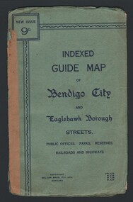 Bendigo Historical Society Inc.
Map - INDEXED GUIDE MAP OF BENDIGO CITY & EAGLEHAWK BOROUGH, Early to mid 1920's
Map. Indexed Guide Map of Bendigo City & Eaglehawk Borough. Folded map contained within blue booklet. Booklet is light blue printed with dark blue ink. Copyright Bolton Bros. Pty. Ltd. Bendigo. Printed on front. Map shows the location of Sailors Gully, Peg Leg Gully, California Gully, Long Gully, Eaglehawk Creek, Bendigo Creek, Ironbark Creek. Shows location of Showgrounds between Park St, Baxter Street, Barnard St and Bridge Lane. Shows location of Golden Square Railway Station between Panton St and Allingham St. Shows what is now known as Creek St. Nth & Sth as Clark St Nth & Sth. Also shows Tramway Terminus along Carpenter St and Golden Square Tram Terminus on High St, Golden Square. Map has a street index and an index for Public Offices, Parks and Reserves.map, bendigo, township, indexed guide map of bendigo city and eaglehawk borough -
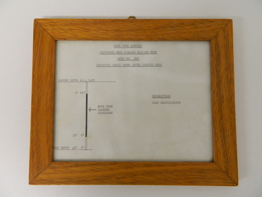 Kiewa Valley Historical Society
Sketch Rock Core Display, circa mid to late 1900's
This framed sketch details, in graphic form, where the core samples in the display cabinet were removed. The drilling was a precursor to the decision where to locate, in this case, the McKay Creek Power Station. The information gained by structural engineers from the core samples would be used also for the placements of underground tunnels entry and exit points and the overall effective size of the plant. This would have included drill and blast techniques(rock characteristics play an import part of explosion control), requirements for support structures and reinforcing cement/steel forms. The use and replenishment of diamond drill bits(the strongest available, see KVHS 0280) was dependent on the "type" of rock found. Support beams for reinforced ceilings and floors was also a necessity.The visual derails of where the rock core samples were removed is very significant in the formulation and placement of the underground Power Stations and their maze of tunnels(in and out) for a successful implementation of the Hydro Scheme. The amount of pre-planning and scientific studies required for such a large scheme must be undertaken to ensure that a "white elephant" was not the result.This framed and glass front rock core display sketch has type written information of the rock samples displayed in KVHS 0279 (A). It has a softwood stained and glossed frame with a fixed(nailed) back board and a brass fixture for mounting onto a wall.The paper and type are slighted faded (sunlight affected). The sign heading "ROCK CORE SAMPLES RECOVERED FROM DIAMOND DRILLED BORE" underneath this "BORE NO: 883" and below this "LOCATION: McKAY CREEK POWER STATION AREA" to the left a sketch incorporating the ground level point "GROUND LEVEL R.L.3493", and the core depth point "CORE DEPTH 40' 7". In between and representing( in visual form) the core location areain question.alternate energy supplies, alpine feasibility studies temperature, rainfall, sec, kiewa hydro scheme, electricity -
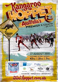 Falls Creek Historical Society
Poster - Kangaroo Hoppet 2011
The Kangaroo Hoppet is Australia’s premier long distance cross country ski race, and a member of the Worldloppet series of international cross country ski events. After running the event for 10 years, it was decided they should become part of the Worldloppet series of marathon ski races. Representatives from the Birkebeiner Nordic Ski Club and the Australian Ski Federation attended the Worldloppet Annual Meeting in Finland in June 1990 to put the case for the acceptance of an Australian event into the Worldloppet series. Before being admitted, they had to demonstrate that the Birkebeiner Club could run a world class event, so three months later in August 1990 a 42km event named the Australian International Ski Marathon was held at Falls Creek together with a 21km Birkebeiner race and a 7km event called the Birkebeiner Lite. The event was approved by delegates from USA, Norway and Austria, in 1991 Australia became the 12th member of Worldloppet, with the condition that there had to be a name change. After some late night discussion allegedly involving red wine from North East Victoria the main event became the 42km Kangaroo Hoppet, with the minor events being the 21km Australian Birkebeiner, and 7km Joey Hoppet. In the winter of 1991, the first Kangaroo Hoppet was held. It was a great success and has been a regular fixture on the international ski calendar ever since. It features the main 42km event as well as a 21km event and a 7km event. The Hoppet brings the Australian snowfields to an international audience. In 2011 the Men's Winner was Petr Novak from the Czech Republic in a time of 1:16:04. The winner of the Women's event was Esther Bottomley of Australia in a time of 1:42:22. Due to lack of snow, the course had to be relocated to the Mt McKay area at the top of the ski resort. The 42km Hoppet course was shortened to 30km.This poster is significant because it documents an event which brings international attention to Falls Creek and the surrounding region.A poster featuring a group of competitors from a previous Hoppet event. A Kangaroo Hoppet road sign is on the left. The page border is yellow. Logos of AGL, Falls Creek All Season Alpine Resort, Alpine Shire, Tourism Victoria, Parks Victoria and the Birkebeiner Nordic Ski Club are across the bottom of the poster.At the top: Kangaroo HOPPET 21 Australia's PREMIER X-COUNTRY SKI RACE On the road sign: KANGAROO HOPPET 42km Beneath the image 27th August 2011/ 42KM 21KM 7KM Below the line of logos: Ph. 03 5754 1045 / [email protected] www.hoppet.com.au Across the bottom in larger cursive text www.hoppet.com.aukangaroo hoppet, worldloppet events, falls creek, mt. beauty -
 Falls Creek Historical Society
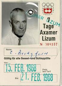
Ski Pass for Axamer Lizum Resort in Austria for C. H. Bridgford, 1968
SKI TICKETS Before tows and lifts were introduced at Falls Creek, it could take skiers 20 minutes to climb to the Summit … but only TWO minutes to go back to the bottom. The arrival of tows, then chairlifts and T-bars changed the face of skiing forever. The first rope tow was constructed by Toni St. Elmo for the 1951 winter season. Bob Hymans installed a smaller tow for his guests at Skyline Lodge. Tows were still quite slow, so in 1956 Bob Hymans created his single chairlift. In 1958 the Village rope tow, designed by Albury engineer Jock Wilson, opened. It was financed by shareholders including Bill Griffith (Bowna Ski Club) and the Bridgford family (St. Trinian’s Ski Club). Several other tows followed including the Summit T-bar in 1961, built by Ron McCallum and operated by Alpine Developments Pty. Ltd. which was a company formed by C. H. (Bill) Bridgford. By 1982 Falls Creek was served by 16 different lifts or T-bars, all owned and operated by Alpine Developments (Holdings) Pty. Ltd. During the development of Falls Creek, different methods have been used to pay for the use of tows, lifts and T-bars … including metal tokens, single tickets, strips of tickets and season passes. The Falls Creek Historical Society Collection includes many examples of these items.This ski pass is significant because it was issued to a pioneer of the ski industry in Falls Creek, Victoria.A plastic covered ski pass for Axamer Lizum resort in Austria. It was issued to C. H. Bridgeford. in 1968. Charles (Bill) Bridgeford built a family lodge called St. Trinian's in the early 1950s. Bill had previously worked in the family shipping firm and had been Member for South Eastern in the Victorian Parliament. He became one of the shareholders in the Village rope tow which had been a failure partly because too many people had been involved. In 1960 Bridgeford approached Toni St. Elmo with an offer to buy the Nissen tow and Nissen Lodge which was accepted. With friends Geoff Henke and Ron McCallum, an engineer, he formed Alpine Developments (Holdings) Pty. Ltd. Ron had also been Lift Manager at Mt. Buller and together they acquired the Village rope tow and replaced it with a T-bar. They gained the franchise to operate all ski lifts and T-bars and later the Falls Creek Ski School. Alpine Developments (Holdings) Pty. Ltd continued to expand the lift network until 1983 when the lifts were sold to Transfield.On front: Photograph and text Innsbruck Olympics 1964 logo in top right Tage M Axamer Lizum № 000157 Gültig für alle Sessel-und Schlepplifte (Valid for all chairlifts and drag tows) 15. FEB. 1968 until 21. FEB. 1968 Preis laut Tarif (Price according to tariff) On back: Condition of use in German, English and Frenchcharles bridgeford, alpine development holdings pty ltd, ski pass, axamer lizum resort -
 Yarra Glen & District Historical Society
Maps
Hand drawn map of Steels Creek and Yarra Glen in black biro on sheets of white paper glued together. The map shows the area from the Yarra River in the south to Mount Slide in the north, in the late 1920s. It includes roads, lanes and creeks; the location of houses with name of resident, features such as water trough and tennis court. Late 20th century features such as Henderson Road have been added in pencil by Eric Tetlow.yarra glen, steels creek, mud map, sketch plan -
 Bendigo Historical Society Inc.
Document - SPYING ON THE GOLDFIELDS BY RALPH BIRRELL
Document, Spying on the Goldfields by Ralph Birrell, Dissatisfaction over the licence issue that festered on the Victorian Goldfields during the early 1850s, might be said to have its genisis at Reid's Creek on the Ovens goldfield. Soon it spread to other fields and particularly to Bendigo Creek where in 1853 it found overt expression in protest meetings and in the formation of the Red Ribbon Movement. Published in the Victorian Historical Journal, Vol.66, No.1, June 1995.Ralph Birrelldocument, names of bendigo pioneers, bendigo -
Bendigo Historical Society Inc.
Map - HARCOURT : COUNTY OF BENDIGO, December 1951
Map. Harcourt, County of Bendigo, County of Talbot, Ravenswood. Sutton Grange, Walmer, Castlemaine, Faraday, Calder Highway, Northern Railway, Town of Harcourt, Barkers Creek, Victorian Water Supply Res., in connection with Barkers Creek Reservoir. By authority J.J. Gourley, Government Printer, Melbourne .Drawn and reproduced at the Department of Lands and Survey, Melbourne. December 1951. Price 2/- per sheet. (number 96 in map cupboard 1)J.J. Gourley, Government Printer, Melbourne.map, bendigo, harcourt -
 Falls Creek Historical Society
Journal - Ski-Horizon Vol. 2 No 11, July 1951
Ski-Horizon is the official journal of the Federation of Victorian Ski Clubs which began publication in 1949. The original member clubs were Albury Ski Club, Alpine Club of Victoria, Australian Postal Institute Ski Club, Australian Women's Ski Club (Victoria), Beechworth Ski Club, Bogong Ski Club, Bull Lodge Ski Club, Chamois Ski Club, C.S.I.R. Ski Club, Edelweiss Ski Club, Howqua Ski Club, Lazy Eight Ski Club, Melbourne University Ski Club, Melbourne Walking Club, Monsanto Ski Club, Moose Ski Club, Myrtleford Ski Club, Rongbuk Ski Club, Tallangatta and District Ski Club, Tanjil Ski Club, Telemark Ski Club, University Ski Club, Victorian Rover Scouts (B.S.A.), Wangaratta Ski Club, Youth Hostel Association, Yurredla Ski Club. Two pioneers of Falls Creek, Tom Mitchell, M.L.A., and Martin Romuld were Vice-Presidents of the Federation. The journal features stories and events chronicling developments in Victoria and internationally.Ski-Horizon is the official journal of the Federation of Victorian Ski Clubs which began publication in 1949. The were 26 original member clubs which included Albury Ski Club, Bogong Ski Club, Myrtleford Ski Club, Tallangatta and District Ski Club and Wangaratta Ski Club. Two pioneers of Falls Creek, Tom Mitchell, M.L.A., and Martin Romuld were Vice-Presidents of the Federation.This Journal is significant because it documents the early development of skiing in Victoria.The journal features stories and events chronicling developments in Victoria and internationally. Items related to the Falls Creek Area in this publication include:- Page 2: Reference to ski instructors and Ski Schools in Victoria including Bob Hymans' School and Ernst and Auriel Forras who operate the Nussen School with Max Denham. Page 5 Bogong High Plains locality map, with construction areas and power lines marked. It is accompanied by a notice regarding safety and access from H. H. C.Williams, Construction Engineer. Page 12 An article referring to Tom Mitchell's stallion "Debtor" and Ernest Forras, Ski Instructor. Page 13: Continuation of Ernest Forras' profile. Page 22 Comment by Toni St. Elmo and the Myrtleford Ski Club Tow. ski history victoria, federation of victorian ski clubs, ernest forras, nissen ski school -
 Falls Creek Historical Society
Journal - Ski-Horizon Vol 3 No 12, August 1952
Ski-Horizon is the official journal of the Federation of Victorian Ski Clubs which began publication in 1949. The were 26 original member clubs which included Albury Ski Club, Bogong Ski Club, Myrtleford Ski Club, Tallangatta and District Ski Club and Wangaratta Ski Club. Two pioneers of Falls Creek, Tom Mitchell, M.L.A., and Martin Romuld were Vice-Presidents of the Federation.This Journal is significant because it documents the early development of skiing in Victoria.The journal features stories and events chronicling developments in Victoria and internationally. Items related to the Falls Creek Area in this issue include:- Page 1:- Resulting from a meeting between Bob Howe (Albury Ski Club) and Tom MItchell (Upper Murray S.C.) a group of Wodonga Boy Scouts have had their first skiing trip under the aegis of Albury Ski Club Page 11: Results for N.E.D.S.A. versus Southern Districts Ski Association (South Island, N.Z.) These events were held at Queenstown as part of the Trans Tasman Tour. Skippy St.Elmo placed 5th in the Ladies' Slalom and 4th in the Ladies' Downhill. Dick Walpole who was to become an Olympian in 1960, placed 5th in the Men's Slalom and equal 4th in the Downhill.tom mitchell m.l.a., toonallook, fred griffith -
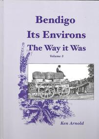 Greensborough Historical Society
Book, Crown Castleton Publishers, Bendigo Its Environs - the Way it Was. Vol 3 / by Ken Arnold, 2013_
A brief history of the areas of Strathfieldsaye, Junortoun, Longlea, Axedale, Kimbolton, Redesdale, Lyal, Myrtle Creek, Axe Creek, Eppalock, Emu Creek, Sedgwick, Mandurang, Mandurang South and Diamond Hill.399 pages, illus. Hard cover.bendigo -
 Kiewa Valley Historical Society
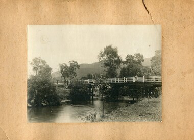
Photographs- 1 old black and white photograph of a wooden bridge over a river possibly Ryders Bridge in Tawonga. 2 –Enlargement of the original photograph showing the gentleman leaning on the bridge. Taken off the original photo
The bridge is not definitively identified, but is of similar construction style to other bridges built in rural areas around this time. Circa 1930”s and may be Ryders Bridge (Old Tawonga Bridge) which crosses the Kiewa River on Mountain Creek Rd Tawonga The first Tawonga bridge was built in 1884- destroyed by floods in 1916. New bridge constructed 1923 and destroyed in 1953. Present concrete bridge constructed in 1986 and named Ryders Bridge These wooden bridges were the only method for transporting stock and produce to market, transporting timber to the mills, sending and receiving mail and for local people to cross the many rivers in the area to go about their daily business. 1- Black and white photograph is glued onto heavy cardboard, which is yellowing with age. Top right hand corner has a tear in the cardboard. Photograph depicts a wooden bridge on wooden piles with 2 white wooden railings along the length of both sides. 2- Original photo has been digitally enlarged to show a gentleman in a light coloured suite and wearing riding boots leaning on the rails of the bridge. The bridge is not definitively identified, but is of similar construction style to other bridges built in rural areas around this time. Circa 1930”s may be Ryders Bridge (Old Tawonga Bridge) which crosses the Kiewa River on Mountain Creek Rd Tawonga bridge; tawonga bridge; kiewa valley -
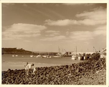 Glenelg Shire Council Cultural Collection
Photograph - Photograph - Portland Harbour, n.d
Con Kroker Private CollectionBlack & white photo. Fisherman's Breakwater on right. Ocean Pier, Whaler's Bluff lighthouse in background. Salt Creek running into sea on lfet, three children fossicking in rocks in foreground. -
Glenelg Shire Council Cultural Collection
Document - Engineering report - typed, 10/02/1964
Five foolscap pages with typed information and photographs, Dartmoor Hamilton Road, Bridge over Humphy's Creek. Stapled top left, signed by E.J.E. Byrne, Bridge Inspecting Engineer.engineering, professional report, bridge, building works, dartmoor -
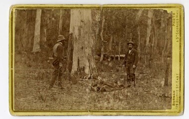 Victoria Police Museum
Carte de Visite (body of Michael Kennedy), Burman Photo, 1878
Small black and white photograph on cardboard showing two standing figures with the covered body of Sergeant Michael Kennedy in the middle. Photograph is taken at Stringybark Creek and shows a bushland settingFinding of Kennedy's Body (written in black ink on rear)stringybark creek, michael kennedy, police murders, kelly gang, bushrangers -
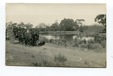 Orbost & District Historical Society
black and white photograph, late 19th - early 20th century
This photograph was taken at the junction of the Snowy and Brodribb Rivers. The Snowy River starts in New South Wales on the slopes of Mt Kosciuszko, Australia’s highest mountain, in New South Wales. It flows into Bass Strait at Marlo in Victoria. The Brodribb River is a tributary of the Snowy which enters the estuary at Marlo. This is a pictorial record of a road in Marlo near Orbost in the late 19th-early 20th centuries. It also depicts the transport used at that time.A black / white photograph of four men in suits seated in a horse - drawn buggy on a dirt road alongside a creek or river. There appears to be another horse - drawn vehicle behind them.on back - "at the Brodribb - Snowy junction. this road was corduroy (packed logs of tea trees?)brodribb-river snowy-river marlo transport-horse-drawn -
Federation University Historical Collection
Booklet, Graeme Wynn, Life on the Goldfields: Fifteen Letters 1853 - 1861, 1853 -1861 (original)
Yellow soft covered booklet of 11 pages, containing transcriptions of fifteen letters written by James William Robertson between 1853 and 1861. Many of the letters relate to Creswick Creek.Inside front cover :Gill you will find some interesting references to the Anderson family with complimetns. Tom Evans. goldfields, james robertson, james william robertson, creswick, correspondence, anderson, m