Showing 22640 items matching "will park"
-
 Phillip Island and District Historical Society Inc.
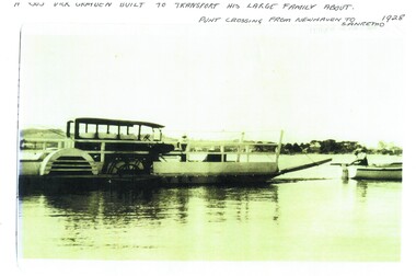
Photograph, Newhaven punt and Nobbies tea house, 1928, 1929
Historical4 A4 photocopies of black & white photos. A large bus on a punt with a person onboard. A small boat with 2 men towing the punt. Land in the background. Wooden building with a group of 6 people standing outside, one looking through telescope.with sloping roof and sign Ye Olde Tea House. Set on barren headland, sea in background with 2 small outbuildngs and a car parked beside building. Other photos show group of cars parked near the same building or on barren headland.A bus Dick Grayden built to transport his large family about 1928. Punt crossing from Newhaven to San Remo. Original tea house at Nobbies. 1929phillip island punt, richard grayden, the nobbies kiosk, point grant, motor car -
 Ringwood and District Historical Society
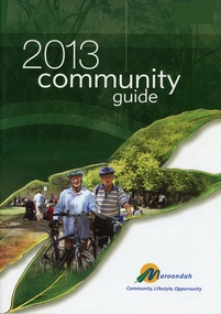
Book, Community Guide 2013 Maroondah City Council, Ringwood Victoria
Community information book issued by City of Maroondah for 2013 covering the facilities and activities of the Ringwood Council and other local organisations and associations. Includes contact details for Council services, community organisations and emergency services. Supplement - Maroondah In Focus newsletter Sept to Nov 2013 includes features Sherbrook Park, Ringwood Library developments, Staley Gardens makeover, Costco opening preparations, Eastland transformation works with QIC Global Real Estate, Railway Station and bus interchange tenders, Ringwood Lake Park improvements. -
 Bendigo Historical Society Inc.
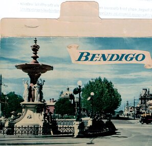
Souvenir - Bendigo Fold-out Postcards, Early 1950s
BHS CollectionCarol Holsworth Collection: Bendigo Fold-out Postcards - 13 Photos of Alexandra Fountain, Botanical Gardens, Conservatory Gardens, Rosalind Park Lookout, Rosalind Park Sound Shell, View from the Lookout, Queen Victoria Gardens, Lake Weroona, the town hall, Charing Cross, the Post Office and Law Courts, Pall Mall and the Sacred Heart Cathedral. On the rear, it is addressed to Mr. R J Randall, c/o A.N.Z. Ltd, Fish Creek, Victoria. Published by Nucolorvue Productions, Mentone, Victoria. history, bendigo, carol holsworth collection, postcard -
 Southern Sherbrooke Historical Society Inc.
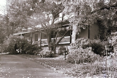
Photograph, Visit to Mt Heatherly, early 2000s
Photos of Mt Heatherly, an historical building in Belgrave, opposite Belgrave Lake Park. Address is Park Drive, on the corner of Waratah Ave. The house is now owned by Mrs Elizabeth Schneider, and was first constructed around 1881 by the first owner of the selection, Ormond Smith. It was made of hand-made bricks made on site, and a foundation of rock and stone. The original house may have had a corrugated iron roof. The original house forms part of the modern house. Photos taken in early 2000s by Susan Heywood-Downard. -
 Southern Sherbrooke Historical Society Inc.
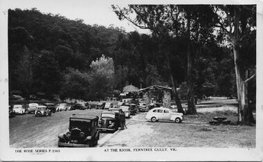
Postcard - At The Kiosk, Ferntree Gully, Vic
B&W postcard, Rose Series P.2365, named 'At The Kiosk, Ferntree Gully, Vic.' Photo shows around twenty or more cars parked outside the kiosk in what is now Ferntree Gully National Park Several people are walking and standing in the carpark and on the paths. The kiosk is visible in the background with advertising signs outside, including one for Peters Ice-cream. Closer to the camera is a stone shelter. There are tall trees beside the carpark and in the background of the photo is a heavily treed hillside. The back of the postcard is blank. -
 Ballarat Tramway Museum
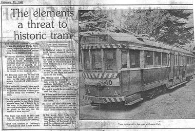
Document - Photocopy, The Courier Ballarat, "The elements a threat to historic tram", 23/02/1985 12:00:00 AM
Photocopy of an article concerning the fate of a Ballarat tram after its return to Geelong and storage in open weather. The tram was in poor condition. BTPS did inspect but did not have the room to store and its poor condition went against recovery. Subsequently acquired by the TMSV and since sold?Photocopy of an article on an A4 sheet from the Geelong Advertiser dated 23-2-1985, titled "The elements a threat to historic tram". Article by David Fitzsimons about the poor condition of the body of Geelong tram No. 40 in Queens Park Newtown. Gives a short history of the tram, including its time in Ballarat as No. 43. Quotes Dr. David Ellerton who reported on the situation, Mr Tom Wilson, City Engineer of Newtown. Has a photo of the tram in Queens Park. Mentions offering the tram to the BTPS.trams, tramways, geelong, queens park, newtown, sale of trams, scrapped trams -
 Kew Historical Society Inc
Archive (series) - Subject File, Kew Historical Society, JELLIS, Thomas G, 1958
Various partiesReference, Research, InformationSecondary Values (KHS Imposed Order)Subject file containing research and primary sources relating to T.G. Jellis and his family bakery in High Street, and later Studley Park Road, Kew. It includes a 1-page summary compiled by Elizabeth Mackie of an interview with his daughter Mrs Whitney, which was separately recorded on tape. A later document is a reminiscence of the bakery in Studley Park Road by Trevor D. Fiander of Ballan. This document includes drawings of the exterior and interior. [An article on the bakery can also be accessed in KHS Newsletter No.104 September 2013.kew historical society - archives, kew - history, t.g. jellis, mayors of kew - t.g. jellis, bakeries - kew (vic), mrs whitney (1895-?), trevor fianderkew historical society - archives, kew - history, t.g. jellis, mayors of kew - t.g. jellis, bakeries - kew (vic), mrs whitney (1895-?), trevor fiander -
Kew Historical Society Inc
Plan - Willsmere Park Estate, Kew, 1926
Subdivision plans and real estate flyers/brochures reveal a number of aspects of urban development and history. The Kew Historical Society's collection of these plans, as well as advertisements extracted from magazines, cover key aspects of community development and architectural history of Kew and Kew Eat as well as surrounding suburbs. While most of the plans in the collection were gifted to the Society by the former City of Kew, a number of other plans and advertisements have been donated by individuals, of which this is an example.Original 4-page, bifold subdivision plan of the Willsmere Park Estate, Kew. The 1926 land sale advertised '40 superb villa allotments' on the 'Yarra Heights'. Streets within the subdivision included: Willow Grove, Kilby Road, Elm Grove and Belford Road. The double page spread on pages 2 and 3 shows the detailed plan of the 40 lots, surrounded by public parkland [Willsmere Park] and the Kew Golf Links. By the time that this version of the plan was released, only the lots on Willow Grove and Kilby Road remained. willsmere park estate -- kew (vic.), subdivisions - kew (vic.), subdivisions -- kew east (vic.), willsmere park -- kew east (vic.) -
 Kew Historical Society Inc
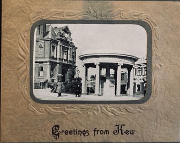
Postcard, Greetings from Kew, c.1928
An item from an outstanding and diverse photographic collection, assembled by members of the Christian and Washfold families of Kew.Rae series of postcards, otherwise unknown, showing important sites in KewSmall folding postcard including nine black and white postcard views of Kew. Cover depicts Kew War Memorial set within an embossed cardboard frame. Individual postcards include: Studley Park Road, River Yarra showing new Bridge [Chandler Hwy], High Street showing soldier's memorial, River Yarra at Victoria Bridge, The Yarra at Studley Park, Holy Trinity Church, the [Alexandra] Gardens, New Yarra Bridge [Burke Rd], Soldiers' Memorial and Post Office Kewwashfold family, christian-washfold collection, postcards -- kew (vic.) -
 Bendigo Historical Society Inc.
Negative - TOM PATULLO COLLECTION: A COUNTRY TOWN
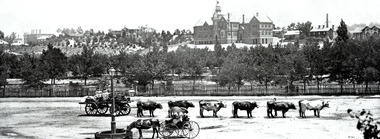
Negative print. Rosalind Park (Camp Reserve), Bendigo looking over Park Road, the Bendigo Creek, Camp Hill State School, with the Bendigo Masonic Hall Left and the Government Camp on the top of the Hill; near where the present day lookout tower stands; to the left of the state school. The Consolidated High School is on the extreme right hand side. The police barracks are between the two schools. The original consolidated school building has been built around and is incorporated into the current Bendigo Senior Secondary School buildings.bendigo, sandhurst, tom patullo collection, bullock wagon, camp reserve bendigo, rosaling park bendigo, camp hill school, bendigo consolidated high school -
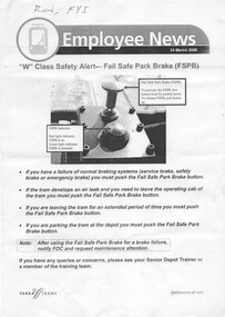 Melbourne Tram Museum
Document - Instruction, Yarra Trams, "W class Safety Alert - Fail Safe Park Brake", "Malvern Terminal Procedures", 24/03/2006 12:00:00 AM
.1 - single A4 sheet - titled "W class Safety Alert - Fail Safe Park Brake", dated 24/3/2006, detailing procedures for the use of the parking braking system fitted to W class tramcars. Includes a photograph of the button. .2 - Instruction - from Staff Induction Manual, detailing terminus procedures for Malvern Depot; University terminus, Malvern Burke Road, Glen Iris, Camberwell and Kew terminus for Z and Combino trams .3 - as above, but includes Luna Park terminus.1 - Has "Ron, FYI" in ink on the top left hand corner.trams, tramways, w class, braking, instructions, malvern depot, university, burke rd, glen iris, kew, luna park, camberwell -
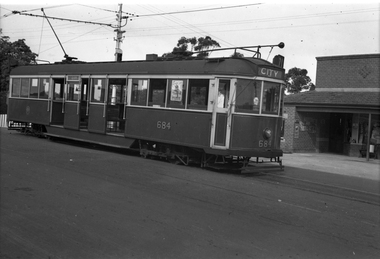 Melbourne Tram Museum
Negative, Wal Jack collection, 1/09/1941 12:00:00 AM
Black and white negative by Wal Jack of Maximum Traction CW5 684 at the intersection of Warragul Road and Riversdale Road with Wattle Park in the background. Tram has the destination of City, Route 71. A RAAF poster can be seen in one of the windows. Above the tram on a pole is a tram signal for the single line operation between Warragul Road and the Wattle Park terminus. See also item 6771 for a photo of the pole itself. Photo dated, 1/9/1941 in the Wal Jack album. See also Reg Itemtrams, tramways, cw5 class, warragul road, riversdale road, route 71, maximum traction, wattle park, tram 684 -
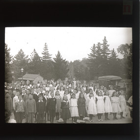 The Beechworth Burke Museum
Photograph - Lantern Slide, c1900
This glass slide depicts a group of school children standing in Queen Victoria Park (previously Beechworth Botanic Gardens), circa 1900. Queen Victoria Park was first secured in 1858 by the Beechworth Council with the assistance of the Central Board of Health (CBH). The CBH was a firm believer in the socially beneficial effects of parks and other recreation areas which is why they aided the council in securing the parkland. the council held a local competition for the design of the park and decided on a plan called "Better late than never" by Hungarian nobleman, J.A. Rochlitz. The first non-native trees were planted in 1861 and have since been heritage listed on the National Trust's register of significant trees. There are nine trees located in Queen Victoria Park that are currently on the National Trust's register. These are the Loblolly Pine, Italian Cypress, Shore Pine, and the Big Cone Pine. These trees hold significance as they date back to 1875 and show rare and localised examples of these types of species which are not seen in many other places in Victoria. The trees in the background of the glass slide depict a species of the pine tree and may be some of the trees still standing in Queen Victoria Park today.This glass slide captures social and historical significance as it not only captures a moment in time of these school children, but it also shows environmental significance for the heritage trees depicted in the background.burke museum, beechworth, lantern slide, slide, glass slide, plate, burke museum collection, photograph, monochrome, queen victoria park, indigo shire, school, j.a. rochlitz, beechworth council -
![Advertising Leaflet, Grace Park Electric Station Estate, Watsonia [1], 21/06/1924](/media/collectors/4f729f5697f83e03086015b8/items/5dcfb6fc21ea671434eb6c09/item-media/5dcfb72a21ea671434eb91fa/item-fit-380x285.jpg) Greensborough Historical Society
Greensborough Historical SocietyAdvertising Leaflet, Grace Park Electric Station Estate, Watsonia [1], 21/06/1924
Digital copy of auction leaflet for sale of land known as Grace Park Electric Station Estate, Saturday 21/06/1924. Auctioneer Knight & Harwood in conjunction with C. Jessop. This leaflet shows a home on the estate and a photograph of the proposed site of the 'Grace Park Railway Station'.Digital copy of auction leaflet 1 page. Black and red text on white paper.watsonia, grace park -
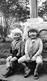 Greensborough Historical Society
Photograph - Digital image, Lobb children at Greensborough War Memorial, 1950c
The Lobb children sitting on the base of the Fallen Soldier's Memorial Greensborough. The Memorial was moved from its original site in Main Street to Lower Park near Mrs Lobb's Kiosk (now Diamond Valley Learning Centre) before a final move to War Memorial Park.This photograph shows the Memorial at its Lower Park site.Digital copy of black and white photograph.Circa 1950fallen soldiers memorial greensborough, lobbs kiosk, lobbs tea rooms, lower park greensborough -
 Greensborough Historical Society
Photograph - Digital image, Lin Lobb sitting on the War Memorial, 1945c
Lin Lobb standing on the base of the Fallen Soldier's Memorial Greensborough. The Memorial was moved from its original site in Main Street to Lower Park near Mrs Lobb's Kiosk (now Diamond Valley Learning Centre) before a final move to War Memorial Park.This photograph shows the Memorial at its Lower Park site.Digital copy of black and white photograph.fallen soldiers memorial greensborough, lobbs kiosk, lobbs tea rooms, lower park greensborough -
Tatura Irrigation & Wartime Camps Museum
Photograph - copy, Mill House, 1986
Photograph of home of Mill House and upstairs extension and bullnose verandah added. Former home of George and Norma Parks and family. Nephew of Dr J. Park. House was connected with former flour mill, now demolished. Now home of Dr and Mrs C. Kerr and family.Black and white photograph of Mill House, Albert Street, Tatura. Exterioron back: Mill House with upstairs extension, home of Dr and Mrs Charles Kerr, Albert Street, Tatura 1986dr and mrs c. kerr, dr j. park, mill house tatura -
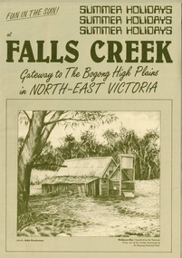 Falls Creek Historical Society
Booklet - Falls Creek: Gateway to the Bogong High Plains in North-East Victoria
A part of a yearly marketing and information material promoting Falls Creek region for the summer holidays. It focuses on Falls Creek's location in the High Plains and its connection to the Bogong National Park. Large amounts of information about activities, facilities and regulations for the use of Park facilities are included,This item is important because it documents seasonal activities at Falls Creek Alpine ResortGreen A4 size brochure for summer holiday program at Falls Creek 'Gateway to the Bogong High Plains'. Dark green printed text and images on lighter green card paper, with image of Wallaces Hut framed at bottom of page and titles above. Opens to A3 size with internal and back pages of images and information for Summer Holidays at Falls Creek. falls creek, bogong high plains, bogong national park, northeast victoria -
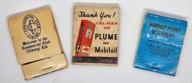 Wodonga & District Historical Society Inc
Functional object - Matchbook collection
This item is from a collection donated by Les Cole of Wodonga, who among several occupations in his life time, drove buses around the Wodonga and district for the Mylon bus company. In March 1952, Transport Parks Pty Ltd. purchased 20 acres of land from the Kelly Estate on the outskirts of Wodonga. The land sold at the record urban price for Wodonga of £300 an acre. They had plans to establish a transport park advertised as the first of its kind in Australia at a cost of £50,000. The park was to have accommodation for up to 1000 transports, caravans and cars, as well as all amenities ranging from showers to a cafeteria. It was to be known as "Twenty Acre Service Station” When the park first came into operation it was to have accommodation for up to 200 transports. Wodonga had been chosen for the site of the company's first park because it was a ''half-way house" between Sydney and Melbourne, and because transports had to stop there to obtain permits to proceed on crossing the border. The service station section of the Transport Park began operation in June 1954, with other facilities following. The business operated profitably until at least 1971 as the Transport Park, but perhaps never reached its aims of providing for 1,000 transports at any given time. The Vacuum Oil Company was the first oil company established in Australia. In 1916, Vacuum introduced its "Plume" brand to the Australian market. Vacuum replaced the famous Plume brand name with Mobilgas in 1954.A collection of 3 different match books representing a variety of businesses.match book collection, matches -
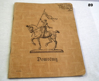 Bendigo Military Museum
Booklet - NOTE BOOK, 6.12.1941
Book contains notes for physical training. Property belonged to Howard Maxwell DAY VX31282, 2nd AIF. Refer Reg No 92.2 for service details also 87, 88, 90, 91.2.Light brown cardboard cover; name & illustration of knight in armour on horseback on front. Inside, lined pages with margins & handwritten notes. Australian Comforts Fund loose sheet inside.Handwritten top right: VX31282 L/Cpl H.M Day 3 Corps Section 1st Aust Ord Fld Park Front centre: Domrémy Bottom left: No 4760documents - notebooks, records, training instructions -
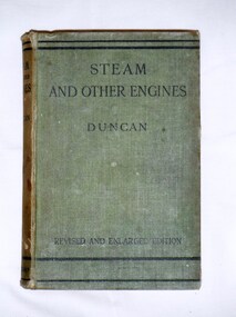 Bay Steamers Maritime Museum
Book, J. Duncan, Steam and Other Engines, 1932
Green cloth hard cover book of 537 pagesFirst page, handwritten in pencil "9/6 / William Jack T?leve / 45 Grand Avenue / Rose Park" Back cover homework instructions in same handwritting in pencilnon-fiction, engineering, steam, science, heat engines, engines, mechanics -
 Bendigo Historical Society Inc.
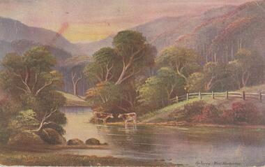
Postcard - Alice McGregor Postcard Collection, 1900 - 1920
Alice McGREGOR Born: 1908; unknown parents. Possibly adopted by the Salter family? Electoral Roll 1936: Highland Terrace Kangaroo Flat. Alice Mary Salter and William Robert Salter living together; presumed to be sister and brother. William Robert Salter was killed in a MVA in Bendigo in 1937 aged 26. In Victoria in 1938, Alice Mary Salter married James Thomas McGregor (born Victoria 1917, died Victoria 1983, buried Fawkner Cemetery) Lived: 1968; 22 Wade Street Golden Square Alice McGregor Died: 1999 aged 91 at Anne Caudle Centre, Bendigo Buried: Kangaroo Flat Cemetery See additional research. Postcard Album of Alice McGregor contained 86 post cards.Postcard Album of Alice McGregor contained 86 post cards. See 1400. Colour painting of a rural scene of 2 cows beside the Yarra at West Warburton. Addressed to Miss H G Shatford, Black Rock, Via Sandringham, Victoria Sender J G D, Emu Park, W East Dated 25 Oct 1906 postcard, collector, alice mcgregor -
 Eltham District Historical Society Inc
Photograph - Digital Photograph, Alan King, Kinglake National Park, 27 March 2008
Fern gullies around Jehosaphat Gully Covered under National Estate. Published: Nillumbik Now and Then / Marguerite Marshall 2008; photographs Alan King with Marguerite Marshall.; p125 The magnificent Kinglake National Park, fringing Nillumbik’s north, is the largest national park close to Melbourne. Thanks to the vision and hard work of a band of local people, the park was created from what was rapidly becoming degraded land. Seeing a threat to Kinglake’s indigenous flora and fauna, several prominent local people campaigned for a national park, which was established in 1928.1 Since then, the park has grown through donations and acquisitions of land, from around 13,800 acres of land (5585ha) to 22,360 hectares. The Sugarloaf and Everard Blocks – of almost 8000 hectares – stand in Nillumbik and the park extends into Mitchell and Murrundindi Shires and the City of Whittlesea. Mt Everard commemorates William Hugh Everard, State member for Evelyn when the park was established. Before 1928, European settlers had degraded the Kinglake area, which was named after the celebrated English author and lawyer, Alexander William Kinglake. Remains of gold shafts and diggings in the park are reminders of Kinglake’s first settlers, who hoped to strike it rich at the gold diggings. But like other gold fields in this shire, they proved not very lucrative and soon timber cutting replaced mining in importance. However, before long, the accessible timber supply ran out, so in the 1920s agriculture took over – particularly potatoes and berry fruits – which involved large-scale clearing.2 The park’s instigator was retired Melbourne University Professor of Music, William Laver.3 As chair of the Kinglake Progress Association he began negotiations to have crown lands on the southern scarp of the Great Dividing Range reserved as a national park. Even before the park was proclaimed, from 1927, KPA members cut tracks to the major scenic points. Professor Laver was one of several people who gave land for the park, donating around 50 acres (20ha), including the Jehosaphat Gully.4 Laver chaired the park’s first Committee of Management, which raised money to employ a ranger and provide facilities, including tracks and roads for fire protection vehicles, toilets and shelters. The committee charged fees for firewood collection, some grazing of livestock, and visitor entrance, and obtained small State Government and Eltham Shire grants. In 1957 the State Government provided revenue for national parks. Then, in 1975, the State Government took over the management and the Committee of Management became an advisory committee, which disbanded in 1978. Originally, the park covered crown land in the Shires of Eltham and Whittlesea; then Wombelano Falls in Yea and other areas were added. In 1970 the park extended into the Shires of Eltham, Healesville, Whittlesea and Yea.5 Bush fires have been an ongoing problem. In 1939 hundreds of eucalypts and acacias had to be sown around the Jehosaphat Gully to rejuvenate the forest. To manage bushfires, the Committee of Management, then the State Government, worked closely with the Forestry Commission, shire councils and local fire brigades. Early national parks focussed on recreation. But by the 1980s, conservation, education and scientific research became more important, playing a vital role in preserving representative samples of the natural environment. Each year many thousands of people use the park’s extensive network of walking tracks amongst the protected plant and animal life as well as camping, cycling and horse riding. The park, along the slopes of the Great Dividing Range, has lookouts revealing magnificent views of the Melbourne skyline, Port Phillip Bay, the Yarra Valley and the You Yangs. Vegetation in the Masons Falls area includes messmate forest, Austral grass-trees, ferns and Hazel Pomaderris. In spring, orchids, lilies, everlasting daisies, correas, grevillea and heath appear. Around Jehosaphat Gully are wet and dry forest, fern gullies and banksia. Animal life includes wallabies, kangaroos, koalas, echidnas, possums, gliders and bandicoots. Male lyrebirds can be heard mimicking in the Jehosaphat Gully, particularly in the Everard Block in winter.This collection of almost 130 photos about places and people within the Shire of Nillumbik, an urban and rural municipality in Melbourne's north, contributes to an understanding of the history of the Shire. Published in 2008 immediately prior to the Black Saturday bushfires of February 7, 2009, it documents sites that were impacted, and in some cases destroyed by the fires. It includes photographs taken especially for the publication, creating a unique time capsule representing the Shire in the early 21st century. It remains the most recent comprehenesive publication devoted to the Shire's history connecting local residents to the past. nillumbik now and then (marshall-king) collection, kinglake national park, jehosaphat gully -
Glenelg Shire Council Cultural Collection
Photograph - Photograph - Hanlon Park, Portland, n.d
Black and white photo of a football match at Hanlon Park, Portland, taken from north side of ground, looking south. Spectators can be seen behind white boundary fence, some footballers close to fence on that side.Back: Round purple stamp: 'PRINTED BY M.E. ANDREWS, PORTLAND' 'Scene of Football Match Portland V Casterton Federal' 'Attendance 400' - handwritten in black inkhanlon park, recreation, football, local sport -
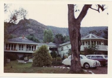 Halls Gap & Grampians Historical Society
Photograph - Coloured, C early 1970s
The photo is of Mountain Grand guesthouse.Photo shows a large building with verandahs in front of the on the left and right wings. Verandah on the right is semi-circular to accommodate the design of the room behind it. A large eucalyptus tree stands in the foreground. Two cars are parked beside the tree."Kodacolor print, Kodak, April-71M" stamped on back in pink.accommodation, mountain grand -
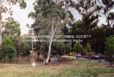
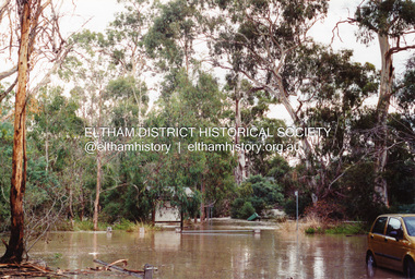
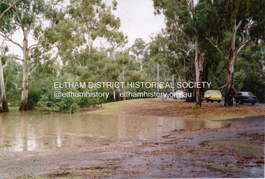 Eltham District Historical Society Inc
Photograph, Flooding of Diamond Creek at Lower Eltham, Feb 2005, 2005
Three colour photographs of the flooded Diamond Creek showing Main Road floodwater below Dalton Street (Eltham Primary) school, west side of Diamond Creek near flower stall and Wingrove Park, Feb 2005eltham, main road, diamond creek, floods, dalton street, wingrove park -
 Victoria Police Museum
Photograph (police car)
Police and police vehicles parked outside a private residence that has experienced severe damage, particularly to the second storey. There are both uniformed and plain clothes police. The Holden has registration number HPJ-699. Circa 1963police vehicles; motor transport branch; motor transport section; holden car -
Ringwood and District Historical Society
Envelope, Packet: Ringwood Sport, Soccer and Various clippings and papers. 1946-1979
Sport - Soccer Wilhelmina history; Certificate - Ringwood East Football Club - premiers 1941; Tennis club - request for permission to conduct tennis court in Miles Park plans - 10 March 1927; Newspaper cuttings - various