Showing 10390 items
matching plan
-
 Port Melbourne Historical & Preservation Society
Plan, J W Banks, Plans and Sections of Tramsway, Apr 1889
Large book of 9 pages, incl. title page, bound on left with black tape, wih plans and typeset descriptions of a proposal to run a cable tram under the Yarra from Williamstown to Melbourne (Falls Bridge) via Port Melbourne. Submitted to Victorian Legislative Assembly 1889Signed p. 2 by J.W. Banks, C.E.transport - tramways, town planning - proposals shelved, williamstown, j w banks -
University of Melbourne, Burnley Campus Archives
Plan, Mont Calm, 1995
Plans for Garden Courtyard in a residential home, "Mont Calm," Prospect Hill Road, Surrey Hills. Student assignment dated 13.02.1995. (1) Assignment details. (2) Student rough notes. (3) Outline on tracing paper. (4) Rough sketch. (5) "Paving to Northern Courtyard."mont calm, surrey hills -
Whitehorse Historical Society Inc.
Legal record - Land Title, Musk Street, Blackburn
Land Titles referring to No. 1 Musk Street, BlackburnLand Titles referring to No. 1 Musk Street, Blackburn : 1. Vol. 542 Fol. 108222, James William Barnes, 1872; 2. Vol. 1877, Fol. 375367, Freehold Investment and Banking Company of Australia Limited, 1886; 3. Transfer 1507851 to John Thomas Williams, 1932; 4. Vol. 8109 Fol. 997 William Henry Rogers, 1955, with Plan of Subdivision CP 21670; 5. cadastral map, AMA zone 55, Sep 2000.Land Titles referring to No. 1 Musk Street, Blackburn musk street, blackburn, no. 1, maple street, blackburn, lawson street, blackburn, elder street, blackburn, barnes, james william, freehold investment and banking company of australia ltd, springfield road, blackburn, whitehorse road, blackburn, barnes estate -
Bialik College
Plan (item) - Bialik College development, 1979-1980
Architectural plans of proposed Bialik College, 429 Auburn Road, Hawthorn East, created by architects Joshua and Mary Pila, May 1979-1980. Please contact [email protected] to request access to this record.1970s, 1980s, building and planning -
 Bendigo Military Museum
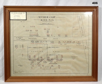
Map - PLAN, FRAMED
LT COL BENJAMIN THOMAS ROY CHADD No's 10594, VX20311, 1st and 2nd AIF. Refer 2039 for Service History also 2034P. Plan, detailing Seymour Camp Block Plan, Signals 7th Aust Div Camp 1940, re LT COL BENJAMIN THOMAS ROY CHADD. Tan coloured frame, glass front, cardboard backing, detail of camp layout, scale 160' = 1".documents - maps/plans, military history - army, frames -
 Whitehorse Historical Society Inc.
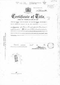
Document, Certificate of Title, 1/06/1951
Certificate of Title Vol 7583 Fol 060, being Lot 72 on Plan of Subdivision No 6626, 50 Burnett Street, Mitcham, with Plan of Subdivision No 6626 including Burnett Street, Thomas Street, bordered by Cook Street and Cook Street and Whitehorse Road, Mitchamburnett street, mitcham, no 50, thomas street, cook road, whitehorse road -
Glen Eira Historical Society
Plan - Centre Road, Bentleigh
Two copies of a one page printed advertisement for the auction of six shops on Centre Road, Bentleigh near Jasper Road to be held on 07/03/1950. The advertisement includes a plan (51mm x 127mm) of the sitesmeldrum w, centre road, bentleigh, plans, advertisements -
 Ringwood and District Historical Society
Flyer, Land Sale Brochure, Heathmont Estate, Vic. - circa 1960
Advertisement for sale of residential lots - Heathmont Estate, opposite Heathmont Railway Station, with map and locality plan.Subdivision includes Canterbury Road, Royal Avenue, Coleman Street, Stoda Street, Herman Street, and Campbell Street. Agent - A.W. Dickson, opposite Station, Ringwood. Phone WU6007. -
 Ringwood and District Historical Society
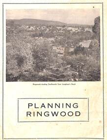
Booklet - Brochure, Planning Ringwood, circa 1946
Brochure on town planning by Cr. H.E. Parker, JP., Mayor of the Borough of Ringwood (Victoria), circa 1946Includes reprinted article from the Melbourne Herald, Tuesday, July 23rd, 1946. - "Ringwood has the Right Idea." -
 Bendigo Military Museum
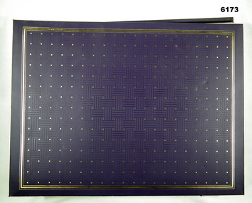
Album - Photographic Identification Guide (PIG) of the Gove Penisula (Sic) Peninsula, Army Topographic Support Establishment, May 1997
These photographs and a video were captured in May 1997 by Jeff Ruiz and Wayne Walsh from the Army Topographic Support Establishment (ATSE). The video taken onboard an aircraft has not been located at this time. A flight line diagram showing the path of the aircraft taking the video is enclosed in the album. The Army Topographic Support Establishment was created to perform some of the functions of the Army Survey Regiment.A Large Purple covered Album with gold dots containing maps, plans and coloured photographs of Gove Peninsula.royal australian survey corps, rasvy, fortuna, army survey regiment, army svy regt, asr, atse -
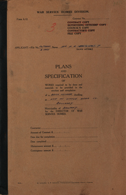 Federation University Historical Collection
Booklet and Plans, Plans and Specification of Works ... at Lot 111 Little Dodd St, Ballarat, c1961, c1961
Brown card cover on plans and specifications for a bick veneer dwelling in Little Dodd Street, Ballarat East.war service homes division, little dodds street, plans and specifications, contract of sale, tenancy agreement, ballarat -
Glenelg Shire Council Cultural Collection
Letter - Letter - Ray Tonkin to Vanda Savill, 28/10/1992
Letter to vanda Savill, from Ray Tonkin, director, Historic Buildings Council, Department of Planning and Housing.vanda savill, heywood, historic building -
4th/19th Prince of Wales's Light Horse Regiment Unit History Room
Booklet, Airborne Air transported Operations No 4 (2 copies), 1945
Soft covered booklet dealing with the planning and the conduct of air transportation of troops and equipment in both aircraft and glidersdoctrine, airborne troops -
4th/19th Prince of Wales's Light Horse Regiment Unit History Room
Lesson Plans, Armoured Centre D&S Wing Ferret Lesson plans, June 1968
Cardboard loose leaf folder containing the lesson plans for the Ferret Scout Car Driving & Servicing Course.ferret scout car, driver training -
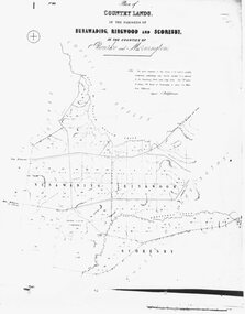 Ringwood and District Historical Society
Photograph, Map-Country Lands, in the parishes of Nunawading, Ringwood and Scoresby (undated)
Early (undated) photograph of plan of "Country Lands, in the parishes of Nunawading, Ringwood and Scoresby, in the counties of Bourke and Mornington". -
Federation University Historical Collection
Book, Denise Lewis (later Denise Boyko), Notes of Lessons, 1968
Denise Lewis married Michael Boyko, also a former student of the Ballarat Teachers' College.Red hard bound book with handwritten lesson plans by Ballarat Teachers' College student Denise Lewis.denise lewis, denise boyko, ballarat teachers' college, class plans, teaching notes -
Federation University Historical Collection
Book, Dr Ian D. Clark et al, Pyrenees Shire, University of Ballarat, Tourism Planning and Development
The Themes that have been most prevalent in the Shire are: Major Mitchell's Impact Pastoral Runs in the Pyrenees Shire Aboriginal History Gold Rush Era Chinese History Wine ProductionPink soft covered book of 35 pages with fifteen appendices. It includes pull out maps and plans. nature based tourism, accommodation, restaurants, transport, attractions, funding, community interest, production development plan, trevor peek, geoffrey gray, djadja wurrung aboriginal clan, the australian tourism commission, tourism victoria, avoca, beaufort, snake valley, amphitheatre, landsborough, lexton, elmhurst, moonambel, mt cole, redbank, mount lonarch, lake goldsmith, st arnaud, lamplough, buangor, natte yallock, navarre/barkly, percydale -
Federation University Historical Collection
Plans, Building Plans for Ballarat Institute of Advanced Education Buildings at Mt Helen Campus, 1971-1972, 1971-1972
Three plans for the Physics and Chemistry Building for Mt Helen Campus, including electrical services and power layout. ballarat institute of advanced education, mt helen campus, physics, chemistry, buildings, architectural plans -
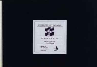 Federation University Historical Collection
Booklet, University of Ballarat Technology Park: Developmental Proposal, January 1995
Blue covered A3 spiral bound booklet with overviews and plans for the development of the University of Ballarat Technology Park.Symbols of the university and City of Ballarat -
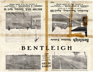 City of Moorabbin Historical Society (Operating the Box Cottage Museum)
Flyer - Bentleigh Station Estate Auction, Coghill & Haughton - W.H. Wood, Bentleigh, c1914
One of the first sales in the district since the land boom which began in 1881when the train line to Mordialloc was built. The land boom came to a halt in the 1890's due to the depression. This sale was also successful as the electrification of the train line from the city to Frankston had been announced.Example of the progress of the Municipality of Moorabbin.Advertising flyer for auction of real estate sales - plan of building blocks for sale - pictures of local area50 Choice Building Blocks adjoining Bentleigh Railway Stationcentre road, mavho street, loranne street, burgess street, bentleigh, bentleigh railway station, real estate, auctions -
 City of Moorabbin Historical Society (Operating the Box Cottage Museum)
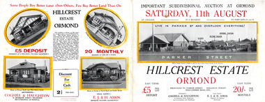
Flyer, 1928
The train line from the city to Frankston was electrified which intensified the sale in the municipality of Moorabbin, particularly land which was in the vicinity of the railway stations.Example of the progress of the Municipality of MoorabbinAdvertising flyer for auction of real estate sales - plan of building blocks for sale with pictures of local housesHillcrest Estate, Ormond - Auction Saturday 11August 1928arker street, holloway street, wild cherry road, ormond, real estate -
 Bendigo Historical Society Inc.
Document - VERN ROBSON COLLECTION: CITY OF GREATER BENDIGO MARKETING PLAN 1994, May, 1994
Bound booklet 15 pages: City of Greater Bendigo Marketing Plan May 1994. G.P. Noonan.bendigo, council, city of greater bendigo -
 Bendigo Historical Society Inc.
Document - BENDIGO HISTORICAL SOCIETY: NATIONAL TRUST NOTES ON THE BENDIGO JOSS HOUSE, Unknown
BENDIGO HISTORICAL SOCIETY: NATIONAL TRUST NOTES ON THE BENDIGO JOSS HOUSE Three pages of notes and a planbendigo, history -
 Bendigo Historical Society Inc.
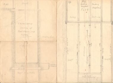
Document - ALBERT RICHARDSON COLLECTION - ENGINEERING DRAWINGS
Document: engineering drawing . Pencil drawing - on bottom of drawing in pencil: ' Plan No. 2 Mill Hoist etc'Alf Richardsonperson, alf richardson, engineering drawing, bendigo, alf richardson, mining, engineering, drawing, mine equipment -
Port Melbourne Historical & Preservation Society
Audio - Urban Planning, Dr Robyn Clinch, John Kirby, 28 Jul 2014
Dr Robyn Clinch discusses the history, development and workings of urban planning. Duration 1.33.27 PMHPS meeting.town planning, heritage, robyn clinch -
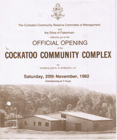 Cockatoo History & Heritage Group
Order of Ceremony, Official Opening of the Cockatoo Community Complex, Saturday 20th November, 1982
In 1976, the Shire of Pakenham recognising that Cockatoo was the second largest township within the shire, acknowledged requests for the provision of recreation facilities. Council purchased four hectares of land strategically located in the Town Centre and in conjunction with the local community, embarked upon a programme of staged development of the site. The first stage saw the construction of the kindergarten building which was opened in 1977, followed by the bowling green, tennis courts, netball courts and public toilets. The Community Complex Building was the final development of the site.The Cockatoo Community Complex building, was the final stage of the development and was opened on the 20th November 1982. It was a replacement for the old Cockatoo Hall, which had not been renovated since 1936. The old Cockatoo Hall was lost in the Ash Wednesday fires on the 16th February 1983. The community complex played an integral part in the recovery stages after Ash Wednesday.Four page document, including Acknowledgements, Order of Ceremony, Menu and Site Plan of the Cockatoo community ComplexTwo punctured holes for folder storagecockatoo community complex, cockatoo hall, hall opening, cockatoo -
 Bendigo Historical Society Inc.
Document - JAMES LERK COLLECTION: DIA GUM SAN FUND RAISING CAMPAIGN, May 1974
Document. DAI GUM SAN fund raising campaign, plan of Action, The Implementation and the Involvement. May 1974.document, memo, dai gum san fund raising campaign -
Bendigo Historical Society Inc.
Map - PART OF THE BOROUGH OF EAGLEHAWK, 9/12/1902
Map: Part od the Borough of Eaglehawk, Parish of Sandhurst, County of Bendigo. Parish plan Canvas backedmap, bendigo, city streets, borough of eaglehawk, parish of sandhurst, county of bendigo -
Bendigo Historical Society Inc.
Map - LANGWORNOR SHEET 2, 26/06/1889
Map: Langwornor sheet 2, County of Dalhousie. Parish plan ( number 173 in Map Cupboard 1)map, dalhousie, parish plan, langwornor, county of dalhousie -
Bendigo Historical Society Inc.
Map - LANGWORNOR SHEET 1, No date visible
Map: Langwornor sheet 1, County of Dalhousie. Parish plan ( number 174 in Map Cupboard 1)map, dalhousie, parish plan, langwornor, county of dalhousie