Showing 6702 items
matching river
-
 Orbost & District Historical Society
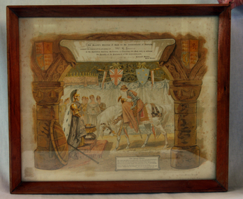
Invitation, 1901
Henry James (1860-1932) was an agent and auctioneer. Record secretary of the Snowy River Shipping company. Shire councillor. Foundation member of Butter Factory.Henry James was a prominent Orbost identity who was very much involved in the local community.Invitation to James, H. (Mr) to the opening of Federal Parliament by the Prime Minister Edmund Bartonon 9 May 1901. Framed in wood, white paper with print of the young queen on a horse holding court. Colour invitations shows a young woman with armour and sword dismounting from a white horse in front of an older woman who has a crown in front of her. Several other women look on. The room is hung with heraldic bunting and shields, including one of the Union Jack and one showing the Southern Cross. The older woman is dressed as Britannia, and her shield and trident are at rest beside her.Printed: His Majesty's Ministers of State for the Commonwealth of Australia/ request the honour of the presence of... / in the Exhibition Building, Melbourne, on Thursday, 9th May, to witness/ the Opening of the Parliament of the Commonwealth./ Edmund Barton/ Prime Minister invitation 1901 parliament james-harry federation snowy-river-shipping-company -
 Orbost & District Historical Society
magnifying glass
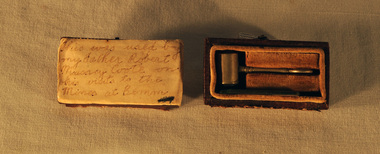
This was used by the father of Massey Coote on his visits to the mines at Bemm River. Robert Massey Coote was the second storekeeper in Orbost - a partner of Lancelot Herbert.Very small magnifying glass in the shape of a hammer. It has concave glass at both ends and comes in a small brown wooden hinged box. A small piece of sheet glass is included.magnifying-glass optical-instrument coote-massey -
 Tatura Irrigation & Wartime Camps Museum
Document, Progress of Irrigation - Story of a "Channel Guard"
Story of a Channel Guard, George Wheeler, who retired from the State Rivers and Water Supply Commission after 46 years working with them.3 A4 pages of typed story.victoria state rivers and water supply commission, george wheeler -
 Tatura Irrigation & Wartime Camps Museum
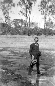
Photograph - copy, Sir Ronald East
Original photo borrowed by Museum for copying. Sir Ronald East as a young man astride the Murray River near Nyah, during drought year -
 Uniting Church Archives - Synod of Victoria
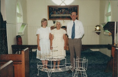
photograph, Undated
Wesley Morris was a Uniting Church lay reader in the Cann River and District Co-Operating Parish (Anglican - U.C.). Formerly with the Methodist church in Noorinbee.Colour photograph of Wesley Morris, Beryl Morris and Christine Morris standing in a church. -
Malmsbury Historical Society
Photograph (Item), B/W Bob Castle & B. Slimmon Fishing, Malmsbury ca1991
People - "Castle, R; Slimmon, B; Manktelow, D" Buildings - Coliban River/Viaduct Associated with - M.H.S.Leader Newspaper (Macedon Ranges) H/Week -
Malmsbury Historical Society
Photograph (Item), B/W Bob Castle & B. Slimmon Fishing, Malmsbury ca1991
People - "Castle, R; Slimmon, B; Manktelow, D" Buildings - Coliban River/Viaduct Associated with - M.H.S.Leader Newspaper (Macedon Ranges) H/Week -
 Lakes Entrance Historical Society
Photograph - Building of PS Curlip, 1/01/2006 12:00:00 AM
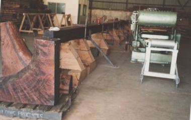
building of PS Curlip replica in old butter factory building Orbost VictoriaBuilt as tourist attraction on river at Marlo. Plus 6 other photos Colour photograph showing building of PS Curlip replica in old butter factory building Orbost Victoria. Plus 9 other photos tourism, boat building -
![Scene near Corranderrk Station / [by] Nicholas Caire, circa 1876](/media/collectors/550653872162f11fb04854aa/items/57774ae0d0cdd10a5c12f2d7/item-media/57774b61d0cdd10a5c132dac/item-fit-380x285.jpg) Kew Historical Society Inc
Kew Historical Society IncPhotograph, Anglo-Australasian Photographic Company, Scene near Corranderrk Station, c. 1876
Nicholas Caire was born on Guernsey in the Channel Islands in 1837. He arrived in Adelaide with his parents in about 1860. In 1867, following photographic journeys in Gippsland, he opened a studio in Adelaide. From 1870 to 1876 he lived and worked in Talbot in Central Victoria. In 1876 he purchased T. F. Chuck's studios in the Royal Arcade Melbourne. In 1885, following the introduction of dry plate photography, he began a series of landscape series, which were commercially successful. As a photographer, he travelled extensively through Victoria, photographing places few of his contemporaries had previously seen. He died in 1918. Reference: Jack Cato, 'Caire, Nicholas John (1837–1918)', Australian Dictionary of Biography. The 1860s marked the beginning of the era of reserves and missions. Six Aboriginal reserves were established during the 1860s. These were under the control of the Board for the Protection of Aborigines. Four were Christian missions receiving government aid. These were Lake Tyers (Anglican) and Ramahyuck (Presbyterian/Moravian) in eastern Victoria for the Gunai/Kurnai clans; Ebenezer (Moravian) in north-west Victoria for the clans of the Wimmera and Lower Murray; and Lake Condah (Anglican) in south-west Victoria. The other two were secular government controlled reserves: Framlingham which, like Lake Condah, was established for the Mara-speaking Gunditjmara and Kirrae-wurrung people of south-west Victoria; and Coranderrk, located about 60 kilometres north-east of Melbourne, for the Kulin clans of central Victoria. In 1863, after a period of devastation to the Kulin people, Coranderrk was established at the junction of the Yarra River and Badger Creek. Reference: http://coranderrk.com/, accessed 24 December 2016An original, rare photograph from the series 'Views of Victoria: General Series' by the photographer, Nicholas Caire (1837-1918). The series of 60 photographs that comprise the series was issued c. 1876 and reinforced a neo-Romantic view of the Australian landscape to which a growing nationalist movement would respond. Nicholas Caire was active as a photographer in Australia from 1858 until his death in 1918. His vision of the Australian bush and pioneer life had a counterpart in the works of Henry Lawson and other nationalist poets, authors and painters.Albumen silver photograph mounted on boardprinted in ink on support l.c.: SCENE NEAR "CORRANDERRK" STATION. / COPYRIGHT REGISTERED. printed in ink on support reverse c.: VIEWS OF VICTORIA. / (GENERAL SERIES.) / No. 9. / SCENE NEAR "CORRANDERRK" STATION. / This scene was taken from the hill near Rourke's Bridge, on the Healesville Road, and displays in the foreground / the River Yarra. The roadway which is seen in the mid-distance has lately been constructed by the Government, / as the old tracks which formerly existed, were liable to be swamped by the periodical overflowing of the River. Mount / Ridell can be seen in the extreme distance immediately behind the roadway. / Corranderrk is the local habitation / for the natives of this district, and is situated on the right hand side of the picture, about a mile and a half / from the roadway. printed in ink on support reverse l.c.l.: J.W. FORBES, Agent, printed in ink on support reverse l.c.: ANGLO-AUSTRALASIAN PHOTOGRAPHIC COMPANY, MELBOURNE. printed in ink on support reverse l.c.r.: 10 Temple Court, Collins Street West.nicholas caire (1837-1918), coranderrk aboriginal station, aborigine, yarra river, badger creek, first peoples, aboriginal and torres straight islander -
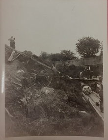
 Orbost & District Historical Society
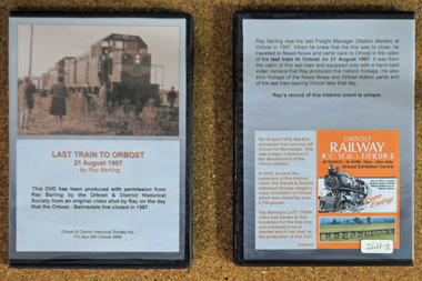
D.V.D. s, Last Train to Orbost, 21.8.1987
These are copies of an original video shot by Ray Barling on the day that the Orbost-Bairnsdale line closed in 1987. He used a hand-held video camera from his cabin on the train, The video was shown at the 2016 Centenary Exhibition in Orbost. The Bairnsdale-Orbost railway was opened in 1916 to serve the agricultural and timber industry. Because of the decline in traffic and heavy operating costs, the line was finally closed in August, 1987. Orbost Railway Station was opened on Monday 10 April 1916 as the terminus of the Orbost railway line, and closed in 1987. The station was located on the west side of the Snowy River despite the town of Orbost being on the east side of the river, in order to save on the costs of a bridge over the river, which at the time had highly variable levels. This item is associated with the history of the Orbost-Bairnsdale railway line and therefore reflects the role that the rail line played in the social and economic history of Orbost. On April 10 1916, the first scheduled train service left Orbost for Bairnsdale. The Bairnsdale-Orbost railway was opened to serve the agricultural and timber industry. Because of the decline in traffic and heavy operating costs, the line was finally closed in August, 1987. Orbost Railway Station was opened on Monday 10 April 1916 as the terminus of the Orbost railway line, and closed in 1987. The station was located on the west side of the Snowy River despite the town of Orbost being on the east side of the river, in order to save on the costs of a bridge over the river, which at the time had highly variable levels, The video was shown for the first time at the Centenary Exhibition held in Orbost, by the Orbost & District Historical Society, t created much interest leading to the production of the videos.Two copies of a D.V.D. titled"Last Train To Orbost 21 August 1987". The cover is a photo of the last train.rail-closure orbost-bairnsdale-railway -
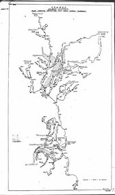
 Kiewa Valley Historical Society
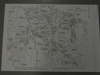
Maps - Squatting Runs of the Murray District 1848 x2, July 26,1848
The Port Phillip Gazette was the second newspaper published in Melbourne, in the then Port Phillip district, now Victoria. In 1948 it was published bi-weekly.The map shows the original names of squatters along the Kiewa River. The names of the district are mostly current today although some are spelt differently.2 copies - 1 laminated & 1 paper of the map of "Squatting Runs of the Murray District 1848." The area is recorded (eg. Tawanga, Dederang, Gundowring, Kergunia, Merrimarenbung all along the Kiewa River) under which the names of the squatter is recorded, the number of acres and the licence number. Scale is 8 miles to the inch.squatting runs; kiewa valley; port phillip district; -
 Bendigo Military Museum
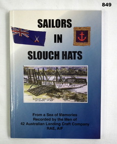
Book, Hesperion Press, Sailors in Slouch Hats, c.2001
Blue & white, soft cover book, 160 pages. 3 pictures on front cover of Australian flag with crossed swords, an anchor within a frame, & larger drawing of a boat pulled up on the edge of a river. 3 sheets of paper posted in inside front cover, inside back cover, & on last page.books, military, history, navy -
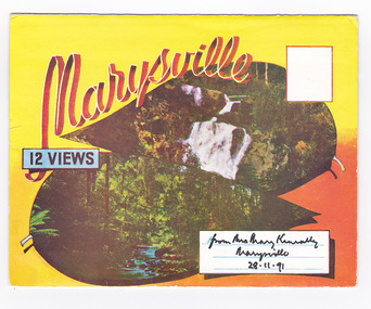 Marysville & District Historical Society
Postcard (item) - Colour photographs, Murray Views, Marysville 12 Views, 1950's
A fold out postcard of 12 colour photographs of scenes and landscapes in and around Marysville in Victoria.A fold out postcard 12 colour photographs of scenes and landscapes in and around Marysville in Victoria. These photographs were produced by Murray Views in Gympie, Queensland as a souvenir of Marysville.Marysville/ 12 VIEWS from Mrs Mary Keneally/ Marysville/ 28.11.91 PRODUCED BY MURRAY VIEWS./ GYMPIE./ Q COPYRIGHT SAMUEL LEE & CO., PRINTERS. STEAVENSON'S FALLS, MARYSVILLE, VIC. TOURISTS AT MARYSVILLE, VIC. "FRUIT SALAD FARM", MARYSVILLE MAIN STREET, MARYSVILLE, VIC. ROAD SCENE, MARYSVILLE, VIC. THE CROSSWAYS, MARYSVILLE, VIC ROAD TO CUMBERLAND VALLEY, MARYSVILLE PANORAMA FROM BLACK SPUR, MARYSVILLE ROAD, MARYSVILLE, VIC. NICHOLL'S LOOKOUT, MARYSVILLE, VIC. TREE FERNS, MARYSVILLE, VIC. THE BRIDGE, MARYSVILLE, VIC.steavenson falls (image 1), tourists in marysville (image 2), taggerty river (image 3), fruit salad farm (image 4), main street marysville (image 5), road scene marysville (image 6), the crossways (image 7), cumberland valley (image 8), black spur (image 9), nicholl's lookout (image 10), tree ferns (image 11), bridge (image 12), marysville, victoria, postcard, souvenir, murray views -
Federation University Historical Collection
Book, Department of External Affairs, Melbourne, Bulletin of the Northern Territory, Bulletin No. 1, March 1912, 1912
Soft brown covered book of 68 pages. Photographic images of Roper River, Mount McMinn, Abraham's Lagoon, Edith Creek, Red Lily Lagoon, Darwin Boy Scouts, China Town in Darwin, Umbrawarra Creek, Paddy's lagoon, McMinn's Homestead, gold cradle, Aborigines, Syphilis, Mungurai, yaws.northern territory, scientific expedition, health, domesticated animals, j.a. gilruth, a. breinl, mosquitos, paul foelscher, roper river, mount mcminn, abraham's lagoon, edith creek, red lily lagoon, darwin boy scouts, china town in darwin, umbrawarra creek, paddy's lagoon, mcminn's homestead, gold cradle, aborigines, syphilis, mungurai, yaws, buffalo fly, henry tryon -
 Bendigo Historical Society Inc.
Map - STATE RIVERS AND WATER COMMISSION : COLIBAN DISTRICT IRRIGATION AND TOWN SUPPLY CHANNELS, 30/11/1956
State Rivers and Water Supply Commission. Foolscap-size map. Title : Coliban district Plan showing Irrigation and Town Supply Channels. The map covers the area from Raywood to Guildford. Scale : 1 inch to 4 miles. Dated 30/11/56, number 5,491 in bottom right corner.state infrastructure, water supply, coliban system, state rivers and water supply commission. coliban system. -
Bendigo Historical Society Inc.
Map - CAMPBELL COLLECTION: BENDIGO AND DISTRICT MAPS, 8-6 29
Map. Kimbolton, Parishes of Kimbolton and Lyell, scale 20 chains to 1 inch. Area by Plamimeter 6258 acres. Coliban River, Knowsley, Strathfieldsaye 10 1/2 miles. Prepared in W.P.B. from Parish and Assessor's Plans. G.W.Latimer 8-6-29. (number 393 in map cupboard 1)G.W.Latimermap, bendigo, allotments -
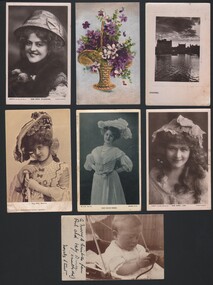 Bendigo Historical Society Inc.
Postcard - WES HARRY COLLECTION: 7 POSTCARDS, 1904 - 08
Seven assorted postcards with various themes : (a) River scene at dusk, entitled ' Eventide ' , (b) Painting of a basket of violets, (c) Miss Marie Studholme (actress), (d) Miss Mabel Love, (e) Miss Billie Burke, (f) Miss May Beattie , (g) Baby Bruce ( 11 months old)postcard, various themes, eventide, basket of violets, marie studholme, mabel love, billie burke, may beattie, baby bruce -
Bendigo Historical Society Inc.
Map - ELLESMERE, COUNTY BENDIGO, 17-3-16
Map, Ellesmere, County Bendigo, Goornong, Bagshot, Muskerry, Wellsford, Axedale, Township of Fosterville.Campaspe River, Bendigo Creek, Railway Line.Photographed at the Dept. of Lands and Survey, Melbourne by W.J.Butson 17-3-16.Price 1/-. By authority Albert J.Mullett, Government Printer, Melbourne. ( number 38 in Map Cupboard 1)Albert J.Mullett, Govt. Printer, Melbourne.map, bendigo, ellesmere -
Bendigo Historical Society Inc.
Map - RUNNYMEDE : COUNTY OF BENDIGO, 8-12-13
Map. County of Bendigo, County of Rodney, Burnewang, Elmore, Nolan, Campaspe, Colbinabbin, Burramboot, Corop, Township of Runnymede, Campaspe River, Mount Pleasant Creek. Photo-Lithographed at the Department of Lands and Survey, Melbourne by W.J. Butson.8-12-13. Price 1/-. (number 107 in map cupboard 1)W.J. Butsonmap, bendigo, runnymede -
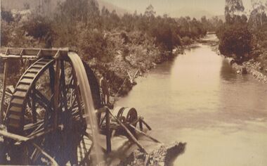 Bendigo Historical Society Inc.
Photograph - PHOTO OF WATER WHEEL, 1900
Sepia Toned Photograph, gold sluicing on the Ovens River near Germantown) Showing a man standing on a water wheel looking over a water course flanked by trees & shrubbery with mountains in the background. Markings on rear Photo read 'N.J. Caire Landscape Photographer 4 Darling Street South Yarra Victoria'N.J. Cairephotograph, water wheel landscape, water wheel, mining -
 Kew Historical Society Inc
Photograph, City of Kew, City of Kew, Cecil Street Drain, 1936
An original photograph donated to the Kew Historical Society by the City's Engineering Department preceding the amalgamation of Kew into the City of Boroondara. While not all of the photographs are of Studley Park, Kew or East Kew, each photo provides a fine snapshot of the work of local government engineering departments of the period. They reveal they types of labour conducted, the techniques used and the equipment and machinery in the possession of the local government authority. Historic and rare photograph of major public works in Kew in the 1930sPublic works. Men at work in the creek bed of Connor's Creek in Kew, while constructing the underground barrel drain. Connors Creek was one of the two main tributaries of the Yarra River in Kew. It originated somewhere near the grounds of Genazzano FCJ College. The barrel drain was finally completed in 1941 at a cost of £14,000. Inscription on reverse: "City of Kew / Cecil st drain / November 1936". public works (kew), roadmaking, engineering, city of kew (engineering department), connor's creek (kew), cecil street drain -
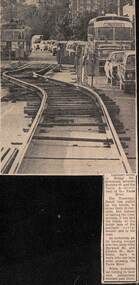 Melbourne Tram Museum
Newspaper, The Age, track reconstruction work in Bridge Road Richmond, c1974
Newspaper clipping from an undated Melbourne page, about track reconstruction work in Bridge Road Richmond, between Burnley St and the Yarra River. Shows the temporary trackwork slew along the road with a long line of cars alongside. In the distance is a tram showing Kew Depot, route 23. Work c1974.trams, tramways, bridge rd, trackwork, route 23, temporary track -
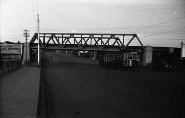 Melbourne Tram Museum
Negative, Wal Jack collection, 1940's
Black and white negative by Wal Jack of W4 670 (Maribyrnong River, route 54), passing under the rail over bridge for the Coburg railway line in Racecourse Road, Flemington. Tram about to cross the Moonee Ponds Creek bridge. Tram number identified on print in album. Photo undated, c1940.trams, tramways, racecourse road, w4 class, route 54, tram 670 -
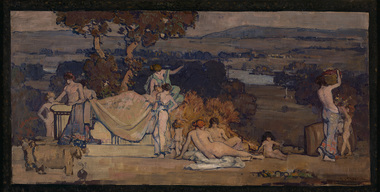 Benalla Art Gallery
Painting, Arthur STREETON, Pastoral design, 1912
Born: Mount Duneed, Victoria, Australia 1867; Lived and workd: England 1897-1919; Died: Olinda, Victoria, Australia 1943EdwardianGift of Wooleen Pty. Ltd., 1980Rural landscape with architectural form and figures naked and partially clothed. Gilded bronze timber frame.Recto: Signed "A. STREETON" in burgandy oil r.l.c of composition; Not dated; Not titledpainting, landscape, figures, nude, river, grecian, tree, animals -
 Ballarat Heritage Services
digital photographs, Lisa Gervasoni, pre olympic pool, c2010-2017
swimming pool, sport, swimming, pre olympic, natural, river, deep rock, yarra -
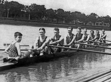 Power House Rowing Club
Black and white photograph, PHRC Maiden VIII Henley Regatta, 1933, 1933
Digital scan of black and white photograph. J Barton Jr (cox) H Rutter (Str) P Hiddlestone (7) R Luff (6) R Manser (5) J Ramsbottom (4) W Wakeham (3) W Tutt (2) V Muller (Bow) J Barton Senr (Coach)rowing, rowers, sweep rowing, men, river, riverbank, sportsmen, sports -
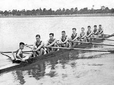 Power House Rowing Club
Black and white photograph, PHRC Maiden VIII Henley, 1935, 1935
Digital scan of black and white photograph. J Barton Jnr (cox) H Rutter (Str) F Huddlestone (7) R Luff (6) R Manser (5) W Ramsbottom (4) W Wakeham (3) W Tatt (2) V Muller (Bow) J Barton Snr (Coach)rowers, rowing, sportsmen, men, river, riverbank, sports, row -
 Greensborough Historical Society
Photograph - Digital Image, Marilyn Smith, The Separation Tree Greensborough 2019, 02/07/2019
The original Separation Tree was one of two red river gums that pre-dated European occupation, and was the site where colonists congregated to celebrate the announcement of Victoria's separation from New South Wales on 15 November 1850. It died as the result of vandalism in 2010 and 2013. Saplings of the original were planted around Melbourne in 2014, including this one along the Plenty River Trail in Greensborough. The old aqueduct bridge can be seen in background.2 colour digital photographsseparation tree, plenty river trail, aqueduct pipe bridge greensborough -
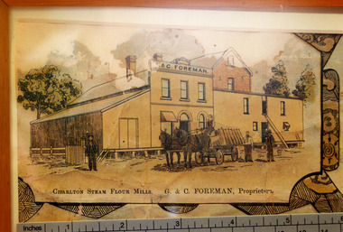 Charlton Golden Grains Museum Inc
Photograph - Lithograph, Rider & Mercer, Views of Charlton
Close up photograph of part of the Charlton Lithograph showing the Charlton Steam Power Flour Mill of G & C Foreman. Located in on the bank of the Avoca river. The mill owners attempted to dam the river during the 1870s. The mill was built in 1876 as recorded by the local traveling correspondent . Foreman's flour mill established 1876 at the west end of High Street. Sold to Norske in 1925. Replaced by Noske's Flour Mill on Kays Street in 1927.Colour photo taken of a small portion of the Charlton Lithograph. Showing the Charlton Steam Flour Mill of G. C. Foreman.Charlton Steam Flour Mills. G & C Foreman proprietors.lithograph, business, industry, charlton, flour mill, noske bros, foreman -
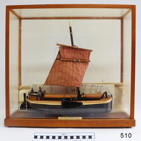 Flagstaff Hill Maritime Museum and Village
Craft - Ship model, 28-01-1985
This unnamed ship model was built by a Warrnambool resident. The Humber Keel design is typical sailing craft used for transport if inshore and inland cargo, from Humber and Hill, around Yorkshire, U.K. in late 19th and early 20th century. Ship model, single mast, double spar, humber keel. Two tone brown and cream paint, light brown sail. Figures of a man, woman and dog on deck. A type of vessel used on the Yorkshire waterways. Perspex case with wooden frame. Folded plans are inside case. Nameplate Plaque inside case describes ship."RIVER HUMBER KEEL/YORKSHIRE/LENGTH 61', BEAM 15'6", DR G CAP 100 TONS/CREW MAN & WIFE, SCALE 1:40/HUON PINE etc. E.H. GRANGER 28.1.1985" on plaque inside caseflagstaff hill, warrnambool, shipwrecked-coast, flagstaff-hill, flagstaff-hill-maritime-museum, maritime-museum, shipwreck-coast, flagstaff-hill-maritime-village, humber keel, sailing cargo