Showing 5252 items
matching view road
-
 Eltham District Historical Society Inc
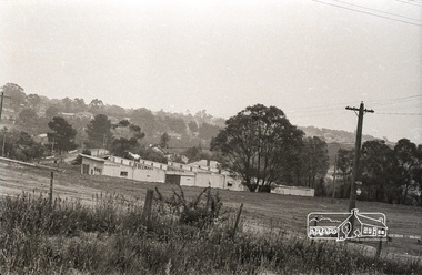
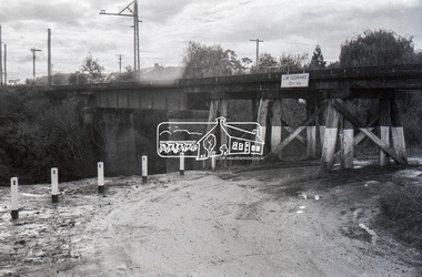
Photograph, Sherbourne Road, Para Road and Simms Road at Briar Hill, 3 November 1967, 3 Nov 1967
Viewed from railway line opposite Graham Body Works. Simms Road is running to the right in front of the old house. The house belongs to Mrs Cameron whose daughter married a DAVEY after which Davey Street is named. Excavation work is being undertaken for the realignment of the Para Road and Sherbourne Road intersection where the current roundabout is located, approximately where the two cars are parked. Mrs Cameron's house and the other are where Montmorency Secondary College is situated. The school opened in 1969.Roll of 35mm black and white negative film, 6 strips Ilford HP3briar hill, cameron, davey, davey road, graham body works, greensborough, montmorency secondary college, sherbourne road, simms road -
 Eltham District Historical Society Inc
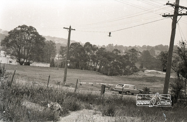
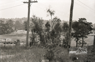
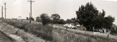
Photograph, Sherbourne Road, Para Road and Simms Road at Briar Hill, 3 November 1967, 3 Nov 1967
Viewed from railway line opposite Graham Body Works. Simms Road is running to the right in front of the old house. The house belongs to Mrs Cameron whose daughter married a DAVEY after which Davey Street is named. Excavation work is being undertaken for the realignment of the Para Road and Sherbourne Road intersection where the current roundabout is located, approximately where the two cars are parked. Mrs Cameron's house and the other are where Montmorency Secondary College is situated. The school opened in 1969.Photostitch from multiple images on roll of film. Roll of 35mm black and white negative film, 6 strips Ilford HP3briar hill, cameron, davey, davey road, graham body works, greensborough, montmorency secondary college, sherbourne road, simms road -
 Eltham District Historical Society Inc
Photograph, Peter Bassett-Smith, Upper Yarra Dam, Spring Tour, 22 Oct 1995, 22/10/1995
EXPLORING THE UPPER YARRA (Newsletter No. 105, November 1995, by Bettina Woodburn) We enjoyed the Spring Excursion, this year "Exploring the Upper Yarra" - in spite of the constant rain and the countryside under the cloud cover, especially in the valleys, being mainly shiny shades of green. The occasional fields of buttercups, clumps of arum lilies and splendid rhododendron and other flowering bushes became very special. The Cobb and Co coach was warm and a cosy retreat as we zig-zagged on the highways and byways to glimpse the Yarra River, upstream and down, its secret places, and particularly the many bridges. Russell excelled as 'Poet Laureate', reading from Dacre Smyth's book. This 1979 publication includes paintings of all the bridges along the river with poems and brief descriptions of each one. Some of the bridges are in out of the way places and are not very well known. We looked forward to hearing the poetry as much as seeing the ' constructions'…Big Pat (was he short or tall, lean or fat? He did win the two hundred pound reward for discovering gold and had the creek named after him), about the 'Eddies'?, and the disliked 'meccano' bridge in Warburton, etc. etc. The hot roast lunch in the old Reefton Hotel was also most welcome. It was easy to imagine it peopled by miners and early settlers. Starting by crossing the new (1974) concrete bridge at Warrandyte we headed through Wonga Park with views to the Christmas Hills and to the escarpment of the Yering Gorge, which causes flood waters to back up through the Yarra Glen plain, so avoiding disasters downstream. At the end of a long driveway we found the wooden, privately owned Henley Bridge (1935 after the 1934 floods). This facilitates access to different parts of Henley Farm and to Lilydale. Everard Park, named after Blanche Shallard's father, a State Member for 17 years, below the Highway Yarra crossing was in need of care. It is 10 miles from Yarra Glen by road but, as "Yarra Marra” canoeists well know, 32 winding miles down by water. After more delightful countryside scenes we joined the Warburton Highway at Woori Yallock. From the old Railway Station at Launching Place the Centennial Trail for walkers, cyclists and ' horse riders has replaced the rails. The line from Lilydale was opened in 1901, and the last diesel freight train ran to Warburton in 1965. It continued to rain as we had morning tea in Warburton in a shelter between footbridges. From here we continued upstream past the Bridge to O'Shannasy Lodge and Reservoir, Starvation Creek, and the Peninsular tunnel (miners dug it as at Pound Bend) which we visited (scrambling down those steps!) on our return after lunch. Our furthermost point was the Upper Yarra Dam Reserve (and vast catchment area). Finished in 1957 after ten years work and 100 years after Yan Yean, it supplies much of Melbourne's water. After crossing the 30m Launching Place Bridge to the Eltham side of the Yarra and Healesville, we saw in the distance the Yarra Glen Timber Trestle Bridge over the river flats "the longest for years in the land it was said!" Harry's dream of "better weather over the Divide" unfortunately didn't come true, but I'm sure we 36 members will retain happy memories of a day that was wet and green and filled with Bridges. Bettina Woodburn - October 1995 Record of the Society's history of activities - Spring 1995 excursionColour photographactivities, upper yarra dam, 1995, peter bassett-smith -
 Eltham District Historical Society Inc
Photograph, Peter Bassett-Smith, Upper Yarra Dam, Spring Tour, 22 Oct 1995, 22/10/1995
EXPLORING THE UPPER YARRA (Newsletter No. 105, November 1995, by Bettina Woodburn) We enjoyed the Spring Excursion, this year "Exploring the Upper Yarra" - in spite of the constant rain and the countryside under the cloud cover, especially in the valleys, being mainly shiny shades of green. The occasional fields of buttercups, clumps of arum lilies and splendid rhododendron and other flowering bushes became very special. The Cobb and Co coach was warm and a cosy retreat as we zig-zagged on the highways and byways to glimpse the Yarra River, upstream and down, its secret places, and particularly the many bridges. Russell excelled as 'Poet Laureate', reading from Dacre Smyth's book. This 1979 publication includes paintings of all the bridges along the river with poems and brief descriptions of each one. Some of the bridges are in out of the way places and are not very well known. We looked forward to hearing the poetry as much as seeing the ' constructions'…Big Pat (was he short or tall, lean or fat? He did win the two hundred pound reward for discovering gold and had the creek named after him), about the 'Eddies'?, and the disliked 'meccano' bridge in Warburton, etc. etc. The hot roast lunch in the old Reefton Hotel was also most welcome. It was easy to imagine it peopled by miners and early settlers. Starting by crossing the new (1974) concrete bridge at Warrandyte we headed through Wonga Park with views to the Christmas Hills and to the escarpment of the Yering Gorge, which causes flood waters to back up through the Yarra Glen plain, so avoiding disasters downstream. At the end of a long driveway we found the wooden, privately owned Henley Bridge (1935 after the 1934 floods). This facilitates access to different parts of Henley Farm and to Lilydale. Everard Park, named after Blanche Shallard's father, a State Member for 17 years, below the Highway Yarra crossing was in need of care. It is 10 miles from Yarra Glen by road but, as "Yarra Marra” canoeists well know, 32 winding miles down by water. After more delightful countryside scenes we joined the Warburton Highway at Woori Yallock. From the old Railway Station at Launching Place the Centennial Trail for walkers, cyclists and ' horse riders has replaced the rails. The line from Lilydale was opened in 1901, and the last diesel freight train ran to Warburton in 1965. It continued to rain as we had morning tea in Warburton in a shelter between footbridges. From here we continued upstream past the Bridge to O'Shannasy Lodge and Reservoir, Starvation Creek, and the Peninsular tunnel (miners dug it as at Pound Bend) which we visited (scrambling down those steps!) on our return after lunch. Our furthermost point was the Upper Yarra Dam Reserve (and vast catchment area). Finished in 1957 after ten years work and 100 years after Yan Yean, it supplies much of Melbourne's water. After crossing the 30m Launching Place Bridge to the Eltham side of the Yarra and Healesville, we saw in the distance the Yarra Glen Timber Trestle Bridge over the river flats "the longest for years in the land it was said!" Harry's dream of "better weather over the Divide" unfortunately didn't come true, but I'm sure we 36 members will retain happy memories of a day that was wet and green and filled with Bridges. Bettina Woodburn - October 1995 Record of the Society's history of activities - Spring 1995 excursionColour photographactivities, upper yarra dam, 1995 -
 Eltham District Historical Society Inc
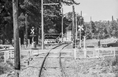
Photograph, George Coop, Level crossing at the Main Hurstbridge Road on the approach to Diamond Creek Railway Station, 6 December 1980, 1980
View from driver's cabinDigital TIFF file Scan of 35mm Ilford FP4 black and white transparencydiamond creek railway station, level crossing, main hurstbridge road -
 Eltham District Historical Society Inc
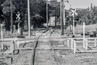
Photograph, George Coop, Level crossing at the Main Hurstbridge Road on the approach to Diamond Creek Railway Station, 6 December 1980, 1980
View from driver's cabinDigital TIFF file Scan of 35mm Ilford FP4 black and white transparencydiamond creek railway station, level crossing, main hurstbridge road -
 Eltham District Historical Society Inc
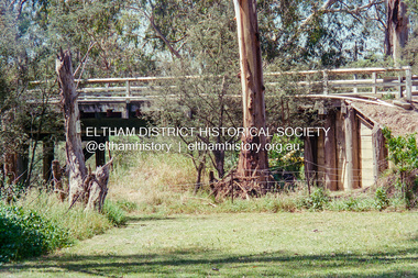
Negative - Photograph, The old Wattletree Road bridge, Eltham on east side of Diamond Creek, 1998c
Viewed from the backyard of the Bakos family residence, 107 Railway Parade Eltham (formerly 137 Railway Parade Eltham) looking north.Roll of 35mm colour negative film, 8 strips and associated 10 x 15 cm colour printKodak Gold 100-5wattletree road, bakos residence, bridge, eltham, railway parade, wattletree road bridge -
 Eltham District Historical Society Inc
Negative - Photograph, Russell Yeoman, Old Lower Plenty Bridge, c.1970
Old bridge across the Plenty River at Lower Plenty now part of the Plenty River Trail. Part of a slide show presentation "Bridges & Waterways of the Shire" by Russell Yeoman to the 13 September 1989 Society meeting. The presentation included slides of historic photos from the Shire of Eltham Pioneers collections as well as several recent views.Roll of 35mm black and white negative film, 4 of 7 stripsIlford HP4bridge, lower plenty, main road, plenty river, plenty river trail -
 Eltham District Historical Society Inc
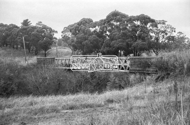
Negative - Photograph, Russell Yeoman, Plenty River railway bridge, near Para Road, Greensborough, c.1970
... views. bridge greensborough para road plenty river Railway ...Part of a slide show presentation "Bridges & Waterways of the Shire" by Russell Yeoman to the 13 September 1989 Society meeting. The presentation included slides of historic photos from the Shire of Eltham Pioneers collections as well as several recent views.Roll of 35mm black and white negative film, 4 of 7 stripsIlford HP4bridge, greensborough, para road, plenty river, railway bridge -
 Eltham District Historical Society Inc
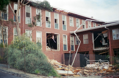
Negative - Photograph, Harry Gilham, Demolition of Eltham Shire Offices (North Wing viewed from Senior Citizens' Centre), 895 Main Road, Eltham, Aug. 1996
The Shire Offices opened in 1965 and were extended in 1971. The final Eltham Shire Council meeting was held in December 1994 before the forced amalgamations of municipal councils by the Kennett Government. The State-Government-appointed Commissioners (1994-1996) took the decision in July 1996 to demolish the Eltham Shire Offices. The demolition works started within 24 hours of the decision being made.Roll of 35mm colour negative film, 5 of 6 strips Associated colour printKodak Gold 100-5eltham shire office, demolition, shillinglaw trees -
 Eltham District Historical Society Inc
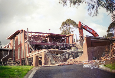
Negative - Photograph, Harry Gilham, Demolition of Eltham Shire Offices (South Wing viewed from Library drive), 895 Main Road, Eltham, Aug. 1996
The Shire Offices opened in 1965 and were extended in 1971. The final Eltham Shire Council meeting was held in December 1994 before the forced amalgamations of municipal councils by the Kennett Government. The State-Government-appointed Commissioners (1994-1996) took the decision in July 1996 to demolish the Eltham Shire Offices. The demolition works started within 24 hours of the decision being made.Roll of 35mm colour negative film, 5 of 6 strips Associated colour printKodak Gold 100-5eltham shire office, demolition, shillinglaw trees -
 Eltham District Historical Society Inc
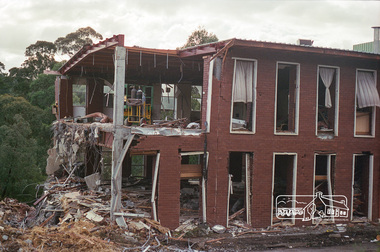
Negative - Photograph, Harry Gilham, Demolition of Eltham Shire Offices (South Wing viewed from Main Road), 895 Main Road, Eltham, Aug. 1996
... Wing viewed from Main Road), 895 Main Road, Eltham Negative ...The Shire Offices opened in 1965 and were extended in 1971. The final Eltham Shire Council meeting was held in December 1994 before the forced amalgamations of municipal councils by the Kennett Government. The State-Government-appointed Commissioners (1994-1996) took the decision in July 1996 to demolish the Eltham Shire Offices. The demolition works started within 24 hours of the decision being made.Roll of 35mm colour negative film, 5 of 6 strips Associated printKodak Gold 100-5eltham shire office, demolition -
 Eltham District Historical Society Inc
Photograph, View from Breakneck, Yarra Glen, 27 August 2016, 27/08/2016
"Until 1865, all wheeled traffic to the Upper Yarra District passed through Christmas Hills along present day Ridge and Muir roads, then followed the hazardous course of "The Breakneck" (now Breakneck Road) to the valley below. To slow the descent of wagons, logs are said to have been dragged behind. In 1865, an easier route was opened on the south side of the Yarra River, and led to the birth of Lilydale". - Christmas Hills Past and Present (Yarra Glen District Historical Society), 2004.Digital copy of colour photographfred mitchell collection, 2016, breakneck, yarra glen -
 Eltham District Historical Society Inc
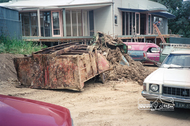
Photograph, Construction of the new Eltham Little Theatre building, 1603 Main Road, Research, c.November 1987, 1987
Rear view of building overlooking gully. Also shows some of the waste material from the gully as part of landscaping works.Roll of 35mm colour negative film, 7 stripsFuji 1001987, building construction, eltham little theatre, main road, research (vic.) -
 Eltham District Historical Society Inc
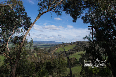
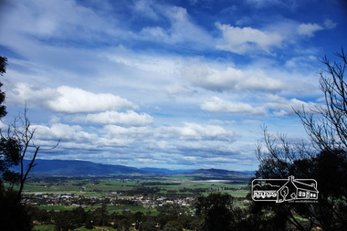
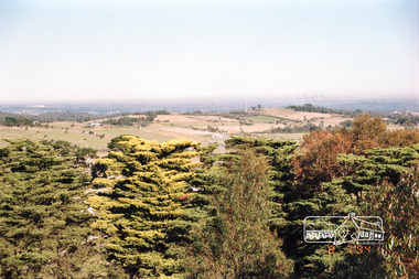
Photograph, View from the Shire of Eltham War Memorial Tower, Memorial Park, Garden Hill, Eltham-Yarra Glen Road, Kangaroo Ground, 8 July 1994, 08/07/1994
On November 11th 1926 the Shire of Eltham War Memorial Tower at Kangaroo Ground was opened. It is regarded as one of Melbourne’s most outstanding lookout towers. It commands a magnificent 360 degree panorama from Kinglake across the Diamond Valley to Macedon and the You Yangs. It is built on a peak which was once a volcano, 237 metres above sea level. After World War one a memorial cairn was erected on the site, and in 1925 a committee of public-minded citizens began to plan for a tower. Many generous donations of material and money were forthcoming so that in 1926 the Governor General Lord Stonehaven was able to unveil the plaque before a crowd of 500 people There was some concern in the 1960s when the Forests Commission wanted to build a firespotters cabin on the top. At first R.S.L. branches opposed the idea, but it was realised that this use could combine with its use as a tourist attraction, and would ensure its maintenance for the future. Today the Kangaroo Ground tower provides one of the best views around Melbourne and is a fitting memorial to those who died in two world wars. From: Historic items for Diamond Valley Community Radio September 1990 (EDHS collection) On November 8th, 1951, the memorial was re-dedicated by the Governor of Victoria, Sir Dallas Brooks with the addition of the names of men from the Shire of Eltham who fell in the Second World War. Further wreaths were added subsequent to this image in time for the 2001 Reembrance Day service to commemorate the men from th shire who had fallen in the Malayan, Korean, Borneo and Vietnam campaigns.Roll of 35mm colour negative film, 4 stripsFuji 100garden hill, kangaroo ground, kangaroo ground memorial, memorial park, shire of eltham war memorial tower, war memorial -
 Eltham District Historical Society Inc
Photograph, View from the Shire of Eltham War Memorial Tower, Memorial Park, Garden Hill, Eltham-Yarra Glen Road, Kangaroo Ground, 8 July 1994, 08/07/1994
On November 11th 1926 the Shire of Eltham War Memorial Tower at Kangaroo Ground was opened. It is regarded as one of Melbourne’s most outstanding lookout towers. It commands a magnificent 360 degree panorama from Kinglake across the Diamond Valley to Macedon and the You Yangs. It is built on a peak which was once a volcano, 237 metres above sea level. After World War one a memorial cairn was erected on the site, and in 1925 a committee of public-minded citizens began to plan for a tower. Many generous donations of material and money were forthcoming so that in 1926 the Governor General Lord Stonehaven was able to unveil the plaque before a crowd of 500 people There was some concern in the 1960s when the Forests Commission wanted to build a firespotters cabin on the top. At first R.S.L. branches opposed the idea, but it was realised that this use could combine with its use as a tourist attraction, and would ensure its maintenance for the future. Today the Kangaroo Ground tower provides one of the best views around Melbourne and is a fitting memorial to those who died in two world wars. From: Historic items for Diamond Valley Community Radio September 1990 (EDHS collection) On November 8th, 1951, the memorial was re-dedicated by the Governor of Victoria, Sir Dallas Brooks with the addition of the names of men from the Shire of Eltham who fell in the Second World War. Further wreaths were added subsequent to this image in time for the 2001 Reembrance Day service to commemorate the men from th shire who had fallen in the Malayan, Korean, Borneo and Vietnam campaigns.Roll of 35mm colour negative film, 4 stripsFuji 100garden hill, kangaroo ground, kangaroo ground memorial, memorial park, shire of eltham war memorial tower, war memorial -
 Glen Eira Historical Society
Album - Album page, Nithsdale now Five Way Hill, Kambrook Road, Circa 1972
This photograph is part of the Caulfield Historical Album 1972. This album was created in approximately 1972 as part of a project by the Caulfield Historical Society to assist in identifying buildings worthy of preservation. The album is related to a Survey the Caulfield Historical Society developed in collaboration with the National Trust of Australia (Victoria) and Caulfield City Council to identify historic buildings within the City of Caulfield that warranted the protection of a National Trust Classification. Principal photographer thought to be Trevor Hart, member of Caulfield Historical Society. Most photographs were taken between 1966-1972 with a small number of photographs being older and from unknown sources. All photographs are black and white except where stated, with 386 photographs over 198 pages. Glen Eira Heritage Management Plan (1996) by Andrew Ward and Associates - Vol 3 "Nithsdale", built for J.S. Crouchin 1858 and extended in 1885 with a tower and associated rooms, survives as testimony to the nineteenth century occupation of the vicinity of the Kambrook/Glen Eira Road intersection. Caulfield's Building Heritage by Dr Geulah Solomon, Vol 1 p49 records it as a small Victorian mansion home on bluestone foundations of Italianate style with a tower. Built for J S Chambers circa 1860, it was built in stages and then the land subdivided in the 1920s. Other owners include Adolph F Brockhoff (of Brockhoff Biscuits company). Names used besides Nithsdale have been Bundoora and Five Way Hill. Page 102 of Photograph Album with four photographs (three landscape and one portrait) of Nithsdale, now known as Five Way Hill. Three views of the tower and one of the house.Handwritten: "Nithsdale" now "Five Way Hill" Kambrook road [top right] / CNR KAMBROOK AND GLENEIRA ROADS [under bottom right photo] / 102 [bottom right]trevor hart, north caulfield, victorian, mid victorian, late victorian, tower, j.s. crouchin, 1850's, 1880's, italianate, rendered, five way hill, nithsdale, slate roof, plaster arches, ornamental columns, triangular pediment, ornamental parapet, cast iron balconies, kambrook road, glen eira road, t crouch, j s crouchin, mansions, j s chambers, bluestone foundations, land subdivision, adolph f brockhoff, bundoora, house names -
 Glen Eira Historical Society
Album - Album page, Rosemont, 112 Kooyong Road, Circa 1972
This photograph is part of the Caulfield Historical Album 1972. This album was created in approximately 1972 as part of a project by the Caulfield Historical Society to assist in identifying buildings worthy of preservation. The album is related to a Survey the Caulfield Historical Society developed in collaboration with the National Trust of Australia (Victoria) and Caulfield City Council to identify historic buildings within the City of Caulfield that warranted the protection of a National Trust Classification. Principal photographer thought to be Trevor Hart, member of Caulfield Historical Society. Most photographs were taken between 1966-1972 with a small number of photographs being older and from unknown sources. All photographs are black and white except where stated, with 386 photographs over 198 pages.From Victorian Heritage Database citation for Rosemont HO124 - 112 Kooyong Road Caulfield North https://vhd.heritagecouncil.vic.gov.au/places/35588 Rosemont'' is situated at no.112A Kooyong Road, Caulfield North and was built in 1869 for Godfrey Howitt, physician, president and honorary physician of the Melbourne Benevolent Society, Council member of the University of Melbourne and founding vice president of the Royal Society of Victoria. It is historically significant (Criterion A) as an early and substantial villa residence demonstrating Caulfield's early attraction as a residential retreat for Melbourne's elite. This significance is enhanced by the associations of the place with Godfrey Howitt and later James Grice, National Bank chairman and owner of "Stonnington" in Glenferrie Road, Malvern and Thomas King, councillor and successful negotiator for the extension of the electric tramway system to the Municipality.Page 110 of photograph album with 4 photos (portraits) of varying views of Rosemont's exterior and garden.Handwritten: "Rosemont" 112 Kooyong Road [top right] / Neg 97 1972 / [under top right photo] / 110 [bottom right]trevor hart, caulfield, john bakewell, francis mcdonnell, gabled slate roofs, rosemont, caulfield north, kooyong road, 1860's, godfrey howitt, james grice, thomas king, villa residence, decorative brickwork, curved windows, bay window, garden, victorian style, mansions, polychrome bricks, porches, arches, parapets, verandahs, slate roofs -
 Glen Eira Historical Society
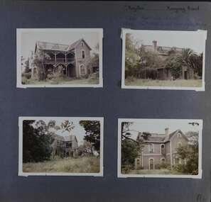
Album - Album page, Royston, Kooyong Road, Circa 1972
This photograph is part of the Caulfield Historical Album 1972. This album was created in approximately 1972 as part of a project by the Caulfield Historical Society to assist in identifying buildings worthy of preservation. The album is related to a Survey the Caulfield Historical Society developed in collaboration with the National Trust of Australia (Victoria) and Caulfield City Council to identify historic buildings within the City of Caulfield that warranted the protection of a National Trust Classification. Principal photographer thought to be Trevor Hart, member of Caulfield Historical Society. Most photographs were taken between 1966-1972 with a small number of photographs being older and from unknown sources. All photographs are black and white except where stated, with 386 photographs over 198 pages. Vol 1 of 4 "Caulfield's Heritage" p34 states that this mansion was demolished in 1972.Page 114 of Photograph Album with four colour photographs (landscape) of different views of Royston in its garden.Handwritten: "Royston" Kooyong Road / 240 KOOYONG ROAD / 1939 - SLATTER - MISS MAY EDITH ALICE. [top right] / 114 [bottom right]trevor hart, caulfield north, kooyong road, 1860's, villa residence, victorian, mansion, ornamented corner stones, royston, renwick, curved windows, timber verandahs, return verandahs, bay windows, may edith alice slatter, may slatter, balconies, polychrome bricks, abandoned buildings -
 Glen Eira Historical Society
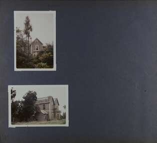
Album - Album page, Royston, Kooyong Road, Circa 1972
This photograph is part of the Caulfield Historical Album 1972. This album was created as part of a project from approximately 1966-1972 by the Caulfield Historical Society to assist in identifying buildings worthy of preservation. This album is related to a Survey the Caulfield Historical Society developed in collaboration with the National Trust of Australia Victoria and Caulfield City Council to identify historic buildings within the City of Caulfield that warranted the protection of a National Trust Classification. Photographers Jenny O’Donnell and Trevor Hart, members of Caulfield Historical Society. Some photographs are older and from unknown sources. All photographs are black and white except where stated. Vol 1 of 4 "Caulfield's Heritage" p34 states that this mansion was demolished in 1972.Page 115 of Photograph Album with two colour photographs (one portrait and one landscape) of different views Royston in its garden.Handwritten: 115 [bottom left]trevor hart, caulfield north, kooyong road, 1860's, mansion, ornamented corner stones, royston, renwick, curved windows, ruins, bay windows, victorian architectural style, polychrome bricks, abandoned buildings -
 Glen Eira Historical Society
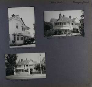
Album - Album page, Tudor Court, Kooyong Road, Dec 1972
This photograph is part of the Caulfield Historical Album 1972. This album was created in approximately 1972 as part of a project by the Caulfield Historical Society to assist in identifying buildings worthy of preservation. The album is related to a Survey the Caulfield Historical Society developed in collaboration with the National Trust of Australia (Victoria) and Caulfield City Council to identify historic buildings within the City of Caulfield that warranted the protection of a National Trust Classification. Principal photographer thought to be Trevor Hart, member of Caulfield Historical Society. Most photographs were taken between 1966-1972 with a small number of photographs being older and from unknown sources. All photographs are black and white except where stated, with 386 photographs over 198 pages. Sands & McDougalls directory of Victoria : 1970 gives address as 141 Kooyong Road, Caulfield North. "Caulfield's Building Heritage" p67 includes that this mansion was originally called Fairhaven, built for George Hope, a dairy farmer. He changed the name to Tudor Court in 1915 when he moved his dairy to Cranbourne.Page 116 of Photograph Album with three photographs (one portrait and two landscape) of different views of Tudor Court in its garden. Handwritten: "Tudor Court" Kooyong Road [top right] / Neg 252 Dec 1972 [under top left photo] / Neg 251 Dec 1972 [under top right photo] / Neg 253 Dec 1972 [under bottom left photo] / 116 [bottom right]trevor hart, caulfield north, kooyong road, mansion, verandah, tudor court, george hope, terracotta tiles, terracotta roof, arched windows, port cochere, square bay window, timber balustrade, columned balcony, receptions, fairhaven, arcare caulfield aged care, 1910's, spire, ridge capping, conical roof, verandahs, victorian architectural style, tudor style, queen anne style, lead lights windows, shingle roofs -
 Glen Eira Historical Society
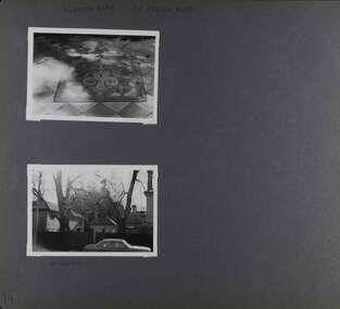
Album - Album page, Heatherbrae, 73 Neerim Road, Circa 1972
... - paving insignia and side view. Heatherbrae, 73 Neerim Road Album ...This photograph is part of the Caulfield Historical Album 1972. This album was created in approximately 1972 as part of a project by the Caulfield Historical Society to assist in identifying buildings worthy of preservation. The album is related to a Survey the Caulfield Historical Society developed in collaboration with the National Trust of Australia (Victoria) and Caulfield City Council to identify historic buildings within the City of Caulfield that warranted the protection of a National Trust Classification. Principal photographer thought to be Trevor Hart, member of Caulfield Historical Society. Most photographs were taken between 1966-1972 with a small number of photographs being older and from unknown sources. All photographs are black and white except where stated, with 386 photographs over 198 pages.From Victorian Heritage Database citation for Heatherbrae HO46 https://vhd.heritagecouncil.vic.gov.au/places/120933 as at (28/10/2020) "Heatherbrae" at 73 Neerim Road, Glenhuntly, is a substantial Victorian residential complex made up of two principal construction stages (pre 1876 and c. 1890) and outbuildings including stables. It is aesthetically, historically and socially significant. Its aesthetic value is demonstrated by the manner in which the two periods of construction survive, the earliest being of greater architectural interest on account of its tower and facade treatment, the latter phase adopting a common villa form. The importance of the complex is heightened by its intact state and surviving outbuildings. "Heatherbrae's" historical significance lies in its link with locally known business man and Shire of Caulfield councillor, John Charles Holland. Its social value rests on its ability to demonstrate a past lifestyle. Page 143 of Photograph Album with 2 landscape photographs of Heatherbrae on Neerim Road - paving insignia and side view.Handwritten: "HEATHERBRAE" 73 NEERIM ROAD [top] / STABLE [under bottom photo] / 143 [bottom left]trevor hart, chimneys, cast iron columns, return verandah, garden, 1870's, neerim road, booran road, 1880's, 1890's, mansion, john c. holland, bluestone foundations, italianate, iron roofed balcony, cast iron balustrade, mosaic tiles, cast iron lookout, flagpole, george f griffiths, residential villa, caulfield, heatherbrae, victorian style, cast iron work, stables, outbuildings, john holland, george griffiths, councillors, mansions -
 Glen Eira Historical Society
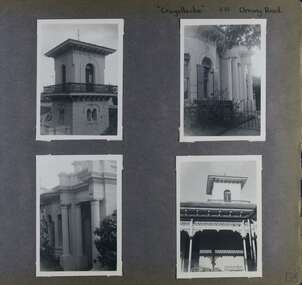
Album - Album page, Craigellachie, 273 Orrong Road, Circa 1972
This photograph is part of the Caulfield Historical Album 1972. This album was created in approximately 1972 as part of a project by the Caulfield Historical Society to assist in identifying buildings worthy of preservation. The album is related to a Survey the Caulfield Historical Society developed in collaboration with the National Trust of Australia (Victoria) and Caulfield City Council to identify historic buildings within the City of Caulfield that warranted the protection of a National Trust Classification. Principal photographer thought to be Trevor Hart, member of Caulfield Historical Society. Most photographs were taken between 1966-1972 with a small number of photographs being older and from unknown sources. All photographs are black and white except where stated, with 386 photographs over 198 pages. From Victorian Heritage Database citation HO40 Craigellachie 2b & 2c Lynedoch Avenue Caulfield North https://vhd.heritagecouncil.vic.gov.au/places/35209 as at (28/10/2020) Craigellachie" is situated at No. 2B Lynedoch Avenue, Caulfield North, and was built for the noted investor, pastoralist and politician, William Pearson, not earlier than 1864 and possible in 1876, undergoing several substantial and contributory extensions during the nineteenth century. It is historically and aesthetically significant. From Victorian Heritage Database citation for HO40 Craigellachie https://vhd.heritagecouncil.vic.gov.au/places/35209 as at (28/10/2020) It is historically significant (Criterion A) as the Melbourne home of William Pearson, MLA, MLC and principal shareholder in Walhalla's Long Tunnel Extended Gold Mining Co. which sustained the township well past the turn of the twentieth century and occupied fifth place amongst Victoria's richest mines. It is aesthetically significant (Criterion E) for its capacity to demonstrate Pearson's continuing financial success throughout the mid to late nineteenth century, the additions associated with the tower being most noteworthy as an example of the lasting appeal of the Italian Style, popularized in the pattern books of the day. The Ailanthus altissima (Tree of Heaven) is significant as an outstanding example of a species that is rare in cultivation, as well as for its very high aesthetic value. The Araucaria bidwilli is notable as a fine example of a species infrequently planted in Melbourne and rarely found in private suburban gardens.Page 156 of Photograph Album with four landscape photographs of Craigellachie - near views of architectural features. Handwritten: "Craigellachie" 273 Orrong Road [top right] / 156 [bottom right]trevor hart, verandah, orrong road, tower, curved windows, decorative brackets, italianate, mansion, 1870's, william pearson, inkerman street, apartments, spire, decorative plaster work, rendered walls, ornamentation, arched windows, moulded ornaments, 1860's, lynedoch avenue, classical style, caulfield north, craigellachie, cast iron work, victorian style, balaclava, st kilda east, gardens, ailanthus altissima, araucaria bidwilli, porches, trees -
 Glen Eira Historical Society
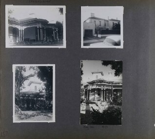
Album - Album page, Craigellachie, 273 Orrong Road, Circa 1972
... gardens. trevor hart verandah orrong road tower cast iron lacework ...This photograph is part of the Caulfield Historical Album 1972. This album was created in approximately 1972 as part of a project by the Caulfield Historical Society to assist in identifying buildings worthy of preservation. The album is related to a Survey the Caulfield Historical Society developed in collaboration with the National Trust of Australia (Victoria) and Caulfield City Council to identify historic buildings within the City of Caulfield that warranted the protection of a National Trust Classification. Principal photographer thought to be Trevor Hart, member of Caulfield Historical Society. Most photographs were taken between 1966-1972 with a small number of photographs being older and from unknown sources. All photographs are black and white except where stated, with 386 photographs over 198 pages. From Victorian Heritage Database citation for HO40 Craigellachie 2b & 2c Lynedoch Avenue Caulfield North https://vhd.heritagecouncil.vic.gov.au/places/35209 as at (28/10/2020) Craigellachie" is situated at No. 2B Lynedoch Avenue, Caulfield North, and was built for the noted investor, pastoralist and politician, William Pearson, not earlier than 1864 and possible in 1876, undergoing several substantial and contributory extensions during the nineteenth century. It is historically and aesthetically significant. From Victorian Heritage Database citation for HO40 Craigellachie https://vhd.heritagecouncil.vic.gov.au/places/35209 as at (28/10/2020) It is historically significant (Criterion A) as the Melbourne home of William Pearson, MLA, MLC and principal shareholder in Walhalla's Long Tunnel Extended Gold Mining Co. which sustained the township well past the turn of the twentieth century and occupied fifth place amongst Victoria's richest mines. It is aesthetically significant (Criterion E) for its capacity to demonstrate Pearson's continuing financial success throughout the mid to late nineteenth century, the additions associated with the tower being most noteworthy as an example of the lasting appeal of the Italian Style, popularized in the pattern books of the day. The Ailanthus altissima (Tree of Heaven) is significant as an outstanding example of a species that is rare in cultivation, as well as for its very high aesthetic value. The Araucaria bidwilli is notable as a fine example of a species infrequently planted in Melbourne and rarely found in private suburban gardens.Page 157 - four photographs of Craigellachie - exterior views. Handwritten: CRAIGELLACHIE [top left] / Neg 212 1973 [under bottom right photo] / 157 [bottom left]trevor hart, verandah, orrong road, tower, cast iron lacework, curved windows, decorative brackets, italianate, mansion, 1870's, william pearson, inkerman street, apartments, spire, decorative plaster work, rendered walls, arched windows, moulded ornaments, 1860's, lynedoch avenue, classical style, caulfield north, craigellachie, st kilda east, late victorian style, garages (private), gardens, cast iron work, ailanthus altissima, araucaria bidwilli, trees