Showing 6702 items
matching river
-
 Bacchus Marsh & District Historical Society
Map, Plan of the property of Messers Atkins and Clarke to be sold at the Mansion, Bacchus Marsh 19th April 1856. Copy 1
This plan of land allotments for sale indicates the property once owned by the Bacchus family in and around the township area of Bacchus Marsh. The Bacchus family sold their property in Bacchus Marsh to John Atkins and Robert Nalder Clarke in March 1851. Atkins and Clarke kept the property for a number of years until April 1856 when these allotments were put up for sale.This plan is almost identical to another copy held by the Bacchus Marsh and District Historical Society, VC Record 452, BMDHS collection). This plan, VC Record 707 Copy 1, contains a little more detail overall than VC Record 452 Copy 2, such as who did the survey work for the plan (R.C. Bagot) and who the selling agents were, (W.M. Tennent), and on the right side of the plan near the Lerderderg River is indicated the general area for a second parcel of land from this sale which is to be sold. There is also a compass illustration indicating north and south compass points.This is a very early land sales plan for the township of Bacchus Marsh and it therefore provides some clues as to how the early urban development of the township took place. Upon seeing the map in 1911 Bacchus Marsh Express newspaper editor Christopher Crisp wrote "The sale appears to have created the present township, which had a nucleus in earlier times further east", Express, 30 September, 1911, page 3.A single page paper plan showing allotments of land for sale. The subdivided land shown was owned by John Atkins and Robert Nalder Clarke, but previously owned by the Bacchus Family and was in and around their Manor House (Mansion) property in Bacchus Marsh.There are 5 portions of land further divided into numerous small portions. The land for sale is bounded by the present day streets of Main Street, Young Street, McFarland Street, Morton Streets, Crook Street, and part of the eastern section extends to the Lerderderg River. Scale: 8 chains to 1 inch The plan is pasted into a bound volume containing 76 maps or plans in total. BMDHS Loc: AR/B12/S4 Bacchus Marsh Township and Nearby Districts Maps Volume In-house Digital copies: BMDHS, Computer Network: Maps\Bacchus Marsh Township and Nearby Districts Maps VolumeHeading: Plan of the first portion of land. The property of Messers Atkins and Clarke situate at Bacchus Marsh. To be sold by W.M. Tennent & Co. at the Mansion on the Ground on Saturday the 19th April 1856. Below heading: Jas Ferguson, Lithographer On upper right side: Subdivided by R.C. Bagot London and Liverpool Chambers, Melbourne. 'Thos Taubman'. Post Office Stamp: BACCHUS MARSH VICTORIA MY 6, 63bacchus marsh victoria maps, bacchus family, land sales, manor house bacchus marsh -
 Orbost & District Historical Society
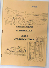
book / document, Shire of Orbost Planning Schemes March 1989, 1989
This document was produced in 1989 for Orbost Shire Council. It ccovers the area s of Orbost, Mallacoota, Cann River and Newmerella and includes urban and non-urban areas.This document is a useful reference tool.A book with a brown front cover with a plastic over-sheet and plastic binding.On the cover are b/w drawings of rural landscapes, trees and the coast. It is titled SHIRE OF ORBOST PLANNING STUDY Part 1 Strategic Overviews, March 1989.orbost-planning -
 Waverley RSL Sub Branch
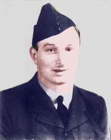
Photo Album, Charles Harold Dix 119700 RAAF Photos of the War Years
Photos taken by Charles Dix 119700 RAAF 2 SQN. at Darwin Adelaide River Morotai and Balikpapan during WWII and 2 photos of later dateCharles Dix 119700 RAAF 2 Sqn. was a member of RSL Waverley Sub Branch for many years. He Joined the RAAF on 8th October 1942 and was discharged from the 83rd. Operational base unit on 30th. January 1946. During WWII and served at Darwin, Adelaide River Morotai Island and made a "beach Landing" under fire at Balikpapan to set up RAAF signals station at the newly captured airstrip Vic Morgan is thought to be MORGAN, Victor Allen - (Leading Aircraftman); Service Number - 88726; File type - Casualty - Repatriation; Aircraft - Mitchell A47-37; Place - Arafura Sea; Date - 14 August 1945Photo Album of mainly black and white photos from WWII Darwin Morotai Island and Balikpapancharles harold dix, darwin wwii, adelaide river wwii, frognal air base, raaf, balikpapan, dix, photos wwii, darwin hospital, jeep, morotai island, 2 squadron r.a.a.f., 2nd squadron raaf, wwii -
 Bendigo Military Museum
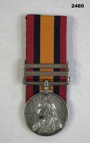
Award - MEDAL, Post 1902
William Harris No 476 enlisted in the 3rd Victorian Bushmans Contingent. He was severely WIA at Koster River on 21.7.1900, invalided back to Australia arriving on 8.11.1900.Medal, court mounted, (1) re W Harris. 1. Boer War medal with 2 clasps "Transvaal & Rhodesia""476 Tpr W. Harris Victorian BSHMN"medals, military, history -
 Greensborough Historical Society
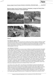
Document - Report, Samantha Westbrooke et al, Batman Apple Tree, & Pioneer Children's Cemetery, Greensborough, 2012, 2012_07
A history of the Batman Apple Tree and Pioneer Children's Cemetery along the Plenty River. Prepared by Samantha Westbrooke Pty Ltd in association with Peter Mills, historian. The Batman Apple tree is said to be over 170 years old, being brought to Greensborough in the 1840s from the Melbourne orchard of John Batman, following Batman's death in 1839. The Pioneer Children's Cemetery is the burial place of 7 children from the Whatmough and Partington families who dies between 1845 and 1858.11 page photocopy, text and black and white illustrations.batman apple tree, robert whatmough, plenty river trail, pioneer childrens cemetery -
![Advertising Leaflet, John McEwen and Co, Heidelberg Park Estate [Lower Plenty], 1913c](/media/collectors/4f729f5697f83e03086015b8/items/5dcfb52321ea671434e9ca4c/item-media/5dcfb56321ea671434ea0352/item-fit-380x285.jpg) Greensborough Historical Society
Greensborough Historical SocietyAdvertising Leaflet, John McEwen and Co, Heidelberg Park Estate [Lower Plenty], 1913c
Copy of auction leaflet for the sale of land fronting the Plenty River. Known as Heidelberg Park, this land is in what is now Lower Plenty. Sale circa 1913Digital copy of auction leaflet, 1 page.heidelberg park, lower plenty, land sales -
 Greensborough Historical Society
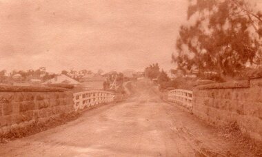
Photograph - Digital image, Main Street Bridge Greensborough, 1910c
View of bridge over Plenty River at Greensborough. Photographs from the collection of Peter Blackbourn, a descendant of the Chapman Stock family. Annotations to photos by Peter Blackbourn.Digital copy of black and white or sepia photograph.peter blackbourn, main street greensborough, bluestone bridge -
 Greensborough Historical Society
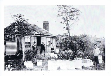
Photograph, Home of Mr Coghill Greensborough, 1910c
Shows the home of Mr Coghill which was the former Mitchell house located between the railway line and the Plenty River and directly opposite the end of Jessop Street.This shows the type of dwelling the early settlers lived in, also what they had in their cottage gardens.A rectangular black and white photograph of 4 men and 1 woman in a garden outside a shingle hut with bee hives near them.shingle hut, cottage garden, bee hives, coghill, mitchell, 1910 -
 Greensborough Historical Society
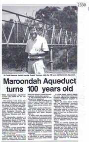
Newspaper clipping, Diamond Valley Leader, Maroondah Aqueduct turns 100 years old, 1991c
Aqueduct of 66 km built between 1886 and 1891 between Watts River near Healesville and Preston Reservoir. Parts have been replaced by pipes.The aqueduct formed a major link in Melbourne's water distribution system after supplies from Yan Yean Reservoir were considered insufficient in the 1870s.Photographic copy, text with photo of Russell Yeomansmaroondah aqueduct, russell yeomans -
![Photograph - Digital image, Willis Vale [Cows], 1920c](/media/collectors/4f729f5697f83e03086015b8/items/5502a0be2162f11024c30d9c/item-media/5502a0e52162f11024c31072/item-fit-380x285.jpg) Greensborough Historical Society
Greensborough Historical SocietyPhotograph - Digital image, Willis Vale [Cows], 1920c
Photograph of four cows at Willis Vale, home of the Partington family. It was located on the Plenty River at Partington's Flat Greensborough. Land use included farming and orchards. Home of the Partington familyDigital copy of black and white photograph.willis vale, partington -
 Greensborough Historical Society
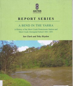
Book, Ian D. Clark et al, A Bend in the Yarra: a history of the Merri Creek protectorate Station and Merri Creek Aboriginal School 1841-1851, by Ian D. Clark and Toby Heydon, 2004_
A history of Aboriginal cultural institutions in colonial Victoria, in this book the interaction between Wurundjeri people and government officials and settlers at the confluence of the Merri Creek and Yarra River.Paperback book, 90 p. black & white illusmerri creek, aborigines victoria -
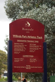 Greensborough Historical Society
Photograph - Digital Image, Marilyn Smith, Willinda Park Sign, 06/11/2017
Willinda Park is situated in Beatrix Street Greensborough. It has an athletics track and field and is adjacent to the Plenty River. This photograph shows the Banyule Council sign at the park.Digital copy of colour photographwillinda park, beatrix street greensborough, athletics -
 Eltham District Historical Society Inc
Photograph, Peter Pidgeon, Killeavey, Laughing Waters Road, Eltham 5 Nov 2016, 5 Nov 2016
The beautiful Yarra river lies before us; the scar or 'toe hold' tree lies in front of Cam to the right Heriitage Excursion - Kileavey Walk and TalkBorn Digitalactivities, eltham district historical society, heritage excursion, kileavey, parks victoria, laughing waters road, eltham, wurundjeri -
 Tatura Irrigation & Wartime Camps Museum
Book, Riverbanker Child a Personal Life
The author grew up on the banks of the Goulburn river, where families lived in tents and shanties. His words and memories of growingt up as a Riverbanker in the 1940'sPart of the history of SheppartonSoft cover book, 52 pages, written by Alan H. Scott. White card cover front and back, Black pencil drawing on front of a tent with patches, a person in doorway, a dog . rear vover has a pencil drawing of a person leaning over a light. printing says Shepparton's Shanties, the Argus, Melbourne ,Vic 1848 -1954. Slum Boards Visit. 'Grievous Wrong being Done" plus other comments. The author has autographed page 1.Autographed by authorgoulburn river, shepparton -
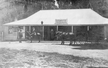 Kiewa Valley Historical Society
Photo - Lagoon Hotel Kiewa - C.A. White
Kiewa is a country town located on the Kiewa River. The hotel was built to supply the local people and those beyond with goods. The hotel continued operating until the 1970s.The town, Kiewa, is in the Kiewa Vally. Lawson's store was a busy place in the 1860s supplying goods to settlements up the river valleys. The Kiewa Post Office opened in 1871. Both businesses continued to operate as the town grew, the post office still providing a service to the local community.Black and white photo of C. A. White's Lagoon Hotel next to the Kiewa Post Office. This photo is published on pages 41 and 42 of 'A History of the Kiewa Valley' by Esther Temple and David LloydOn the back 'From Mrs E. Temple ' Tangambalanga 3691 / President of Kiewa Valley Historical Society' And below - 'Lagoon Hotel, Kiewa / Built by James Lawson 1860 / Post Office opened March 1871 / Building destroyed by fire Jan. 21st 1971'kiewa town, lagoon hotel, kiewa post office, james lawson -
Lakes Entrance Historical Society
Photograph - Timber Beacon Gippsland Lakes, 1900 c
On back of original Raymond Island Tambo River in distance. This survey lookout has been washed away, seawater has killed vegetation and allowed erosionBlack and white photograph of a timber beacon on land in Gippsland Lakes in vacinity of Raymond Island Victoriaboats and boating, navigation, waterways -
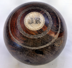 Orbost & District Historical Society
bowl
Owned by Alexander Cameron who arrived in Australia in 1853. Alexander Cameron ("Big Alex") was an early settler on the Snowy River flats. he worked the paddle steamer Cheviot for a while, having a wharf and sheds on the Snowy River in 1900. Later moved to Cann River. The Bowling Club was founded in 1929, by a group of farmers and businessmen. They set about providing a sporting icon for the town. Six rinks were constructed on the current site using horse drawn scoops and drags. The "Back to Orbost” 1937 book, describes the greens as "a bit rough for the first two seasons but now compare favourably with most country greens". Funds for the construction were raised by the issue of debentures at £5 each, and subscriptions were £1/1s/0d ($2.10). (info. Margaret Smith)Alec Cameron was a prominent early Orbost settler. The Orbost Bowling Club was established in 1929.Wooden lawn bowl with wooden circles on top and bottom. Top- I Bottom - J.R.22recreation sport lawn-bowls cameron-alexander -
 Eltham District Historical Society Inc
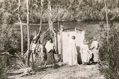
Photograph, Bend of Islands, c.1926
Bend of Islands is named after a group of small islands at a bend of the Yarra River near Watsons Creek. It is located near the town of Kangaroo Ground. The locationn was a long time favourite spot for locals and visitors to fish and swim in the river. This is one of a series of four photographs that depict a mainly young group of people recreating in the area, particularly enjoying horse riding. Possibly weekend campers. Photos taken about 1926-1928. In 1938 "The Argus" advertised weekend cabins at the Bend of Islands estate 5-are Yarra Yarra frontage in the Christmas Hills Gorge ideal for weekend cabins. "Bathing, fishing, canoeing, shooting may be enjoyed in ideal surroundings". This photo seems to be depicitng women waiting to use the shower near the river, or are they going swimming?Black and white photograph (reproduction)Bend of Islands, c.1926 bend of islands, camping, shower block, yarra river, swimming -
 Orbost & District Historical Society
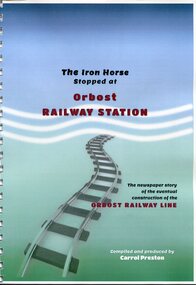
Book, The Iron Horse Stopped at Orbost Railway Station, 2019
Carrol Preston has used newspaper references from 1877 through to 1917, to document the history of the Orbost - Bairnsdael railway line.. It starts with the lobbying and jockeying, and moves through to the opening in 1916. The title is a reference to plans to further extend the railway beyond Orbost - but "The Iron Horse stopped at Orbost Railway Station". Most articles are from the Snowy River Mail and Bairnsdale Advertiser. All newspaper articles are dated and sourced. About 1912 work began at Newmerella on clearing the track for the railway line from Bairnsdale to Orbost. A canvas town sprang up on the higher land adjacent to the river flats. Local farmers supplied meat, milk and fresh produce to the camp, as well as gaining employment carting and labouring. The line opened in 1916, the Orbost railway station being built on the Newmerella side of the river.This item is associated with the history of the Orbost-Bairnsdale railway line and therefore reflects the role that the rail line played in the social and economic history of Orbost. On April 10 1916, the first scheduled train service left Orbost for Bairnsdale. The Bairnsdale-Orbost railway was opened to serve the agricultural and timber industries. This book has been compiled by a local historian. A spiral bound book titled, "The Iron Horse Stopped at Orbost Railway Station". The cover is blue / green with the title in black and red print. Underneath is a railway track leading to the bottom of the page. The book is 110 pages, A4 size and contains maps and photos. in black print on cover - "The Iron Horse Stopped at Orbost Railway Station ; The newspaper story of the eventual construction of the ORBOST RAILWAY LINE (in red print); Compiled and produced by CARROL PRESTON (in white print)railway-transport orbost-bairnsdale-railway east-gippsland-railway -
 Eltham District Historical Society Inc
Book, Jenny Brown et al, Out of the Mist; Osborne Peninsula, 2024
The Osborne Peninsula on the Yarra River at Warrandyte accommodates a limited number of properties and residents (70 households). The area is rich in geology and ecology, and an unusually rich endowment of human, built and creative history. Contents: Welcome: The landform: The River: Aboriginal occupation: The Miners: North Warrandyte :The Subdivision: The Lowes: The Osbornes: The Last Osborne: The Elders: The Relics: Dray Track: Water Wheel"Kauri Plaque: River track: Pines: Windmill Creek Bridge: The Koornong School: The Houses" Man Cave: MidCentury Classic: Enduring Original" Masterwork: The Muddies: The State Park: The Saving of Koornong Reserve: The Landcare Story: Flora and Fauna: The Vulnerable, Endangered and threatened: Birds: Mammals: "Waring" the wombat: Reptiles: Fish: Invertebrates: Flora: Fire. Published by the North Warrandyte (Osborne Peninsula) Landcare Group. Includes photos from EDHS collection.64 p. : ill., map ; 29.7 x 21 cm. (2 copies)yarra river, birrarung, dray track, fauna, geology, houses, indigenous history, koornong reserve, koornong school, lowe family, mining, mudbrick houses, north warrandyte, osborne family, warrandyte state park, water wheel, north warrandyte (osborne peninsula) landcare group, osborne peninsula -
 Ballan Shire Historical Society
Map - Map. Kerrit Bareet, Department of Lands and Survey, Kerrit Bareet. County of Grant, 08/1944
A map of the Kerrit Bareet area within the County of Grant showing properties and names of owners in 1944.Significant to people researching land usage and ownership. Also those researching families in the area at that time.A map of Kerrit Bareet in the County of Grant. Black printing on buff coloured paper. Details roads, rivers, railways, property boundaries and names of property owners and towns and villages. The map is easily readable although there is some physical damage and that and the borders have been reinforced with sellotape. Shows a Scale in Chains and Price 2/.gordon, bungal, kerrit bareet, lal lal, moorarbool river, warrenheip, bungaree, wallace, moorarbool west -
 Bendigo Military Museum
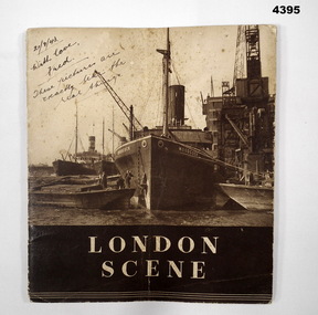
Book - SOUVENIR BOOK, Vandyke Printers LTD, London Scene, C.WW2
Souvenired by Fred Davey on a visit to London during WW2, it was sent to the recipient on 21.9.1943, part of the Frederick Gardner Davey DFC RAAF collection. Refer Cat No 3536P for his service records.Book, soft cover with stapled pages, front cover features a sepia tone photograph of ships in dock, a group of men on a barge is in the foreground, book title in white lettering on a dark background, pages are not numbered and feature sepia tone photo’s with captions, picture on the rear cover features, boats on a river with buildings in the foreground.Hand written on front cover in black ink, “ 21/9/43. With love Fred. These pictures are exactly like the real thing”souvenirs, london, -
Glenelg Shire Council Cultural Collection
Map - Map - RACV Road Map, 1970s
RACV road map, Portland district, Port MacDonnell to Warrnambool. Large coloured map of Portland District, small maps of Portland, Mt Gambier, Hamilton, Mount Eccles National Park, Coonawarra Wineries. When folded, black and white phot of child fishing on jetty on Moyne River, Port Fairy on coverroad touring, racv, map -
 Glenelg Shire Council Cultural Collection
Photograph - Photograph - Entrance to Richmond Hotel Centenary Celebrations Portland 1934, 1934
Photographs taken by Esther Winifred Hall (nee Smallpage) - great grand-daughter of Stephen George Henty. Taken in 1934 Centenary Celebrations in Portland.Back: "Original Home of Stephen George Henty. To E.... Hall from Marg...."centenary celebrations portland 1934 -
Glenelg Shire Council Cultural Collection
Photograph - Photograph - Miss Narrawong 1951, 2009
Black and white reprint. Young woman in bathers and wearing a 'Miss Narrawong 1951' sash, shaking hands with an older woman in a spotted dress and large hat. A man in jacket, shirt and tie and long trousers standing between them. They are all on some sort of platform, above a crowd of people. Surrey river in background.Front: 'Miss Narrawong 1951 Shirley Levitzke Names of others in photo' - blue biro -
 Bendigo Historical Society Inc.
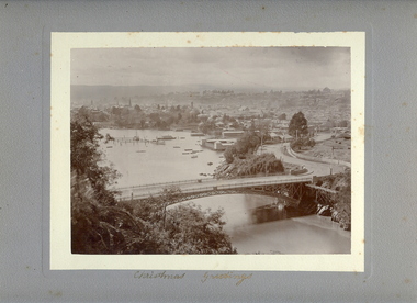
Photograph - VIEW OF LAUNCESTON FROM CATARACT GORGE, c.early 1900's
Sepia photo on grey mount of elevated view of river with single span bridge, with boats moored. Swimming baths in centre to right. Town with church spires and houses and hills in background. Inscriptions 'Christmas Greetings' gold ink underneath photo. On back - written in pencil 'City of Launceston, Tasmania from Cataract Gorge'.W Vincent Kelly, Mitchell St., Bendigoplace, landscape view, launceston, tasmania -
 Bendigo Historical Society Inc.
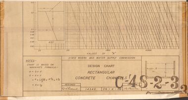
Document - STATE RIVERS AND WATER SUPPLY COMMISSION : DESIGN CHART RECTANGULAR CONCRETE CHANNELS
State Rivers and Water Supply Commission. Coliban System. Lake Eppalock construction. Design chart of Rectangular Concrete Channels (42cm x 63.5cm) is stamped C-'48-2-3. Attached is a page labelled Open Channel Flow Diagram (33cm x 42cm), stamped C-'49-2-3.state infrastructure, water supply, coliban system, state rivers and water supply commission. coliban system. lake eppalock. -
Bendigo Historical Society Inc.
Map - DERBY : COUNTY OF BENDIGO, 1959
Map. Derby, County of Bendigo, Inglewood, Tarnagulla, Woodstock, Leichardt, Bridgewater, Loddon River, Bendigo Railway, Calder Highway, Maldon to Bridgewater Road.By authority A.C. Brooks, Government Printer, Melbourne. Drawn and reproduced at the Department of Lands and Survey, Melbourne, 1959. Price 5/-. (number 59 in map cupboard 1)A.C. Brooks, Government Printer, Melbourne.map, bendigo, derby -
Bendigo Historical Society Inc.
Map - HAWKESTONE : COUNTY OF BENDIGO, December 1953
Map. Hawkestone, Parish, County of Bendigo, County of Talbot, Sutton Grange, Redesdale, Faraday, Elphinstone, Metcalfe, Lyell, Coliban River, Myrtla Creek. By Authority W.M. Houston, Government Printer. Drawn and reproduced at the Department of Lands and Survey, Melbourne. December 1953. Price 2/-. (number 99 in map cupboard 1)W.M. Houston, Government Printer.map, bendigo, hawkestone. -
Bendigo Historical Society Inc.
Map - SALISBURY WEST : COUNTY OF BENDIGO, 3-3-1944
Map. Salisbury, County of Bendigo, County of Gladstone, Powlett, Yarrayne, Bridgewater, Inglewood, River Loddon, Bullabul Creek, Glenalbyn, Kurting. By Authority H.E. Daw, Government Printer, Melbourne. Drawn and reproduced at the Department of Lands and Survey, Melbourne., 3-3-1944. Price 5/-. (number 94 in map cupboard 1)H.E. Daw, Government Printer, Melbourne.map, bendigo, salisbury west