Showing 3585 items
matching steel
-
 Flagstaff Hill Maritime Museum and Village
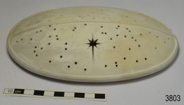
Ceramic - Cover, circa 1883
This ceramic cover was recovered from the wreck of the 1882-1883 George Roper between the late 1960’s to early 1970’s. It is one of the shipwreck artefacts in the John Chance Collection. The purpose of the cover is unclear. The holes could be for ventilation. The cover may have been used to protect food or keep it at an even temperature. It may also have been used for covering fragrant petals, allowing some scent to escape through the holes. The residue around the underside of the holes and their random placement indicate that the cover could be partially handmade. The discolouration could have come from its time in the sea. The GEORGE ROPER 1882 - 1883 - The George Roper was a 4-masted iron sailing ship built in Liverpool, England, in 1882 for fast international trade with Australia. The large vessel was launched in February 1883. The ship was on its first trip, departing Liverpool for Melbourne, captained by John Ward and a crew of 31. She had almost reached her destination on July 4 1883, approaching Port Phillip Bay and being towed by the steam tug William. The weather changed to rough with fog and both the George Roper and the William hit the dangerous Lonsdale Reef at Port Phillip Heads. The Captain and crew were eventually rescued and taken to Queenscliff. Salvage syndicates were able to recover a lot of the cargo before the George Roper broke up and sank. Amongst the cargo was soft goods, draperies, household items, spirits of malt and distilled liquors, chemicals, dynamite, and 1,400 tons of steel rails for the Victorian Government. Also in the hold were Russell Stourbridge bricks, as paying ballast. The ventilated cover is as an example of domestic ceramic ware of the 1880s. The cover also holds significance as it was recovered by John Chance, a diver from the wreck of the George Groper in the 1960s-70s. Items that come from several wrecks along Victoria's coast have since been donated to the Flagstaff Hill Maritime Village’s museum collection by his family, illustrating this item’s level of historical value. The George Roper is considered historically and archaeologically significant and as such, is listed on the Victorian Heritage Database, VHR S286. It is an example of a vessel built specifically for fast travel to and from Australia with a large shipment of cargo. The George Roper’s cargo of steel rails adds to the historical significance of international trade to the growing colony of Australia and Victoria in particular, with rail transportation soon to become a faster and safer form of transportation between colonial towns. Divers can still access parts of the scattered wreck and other artefacts recovered in the 1970s and 1980s can be viewed in both public and private collections. Cover; unglazed white ceramic, oval shape. The cover has holes randomly poked through its surface, one large hole is a six pointed star shape. Underneath there is a narrow rim placed slightly inside the edge. There is residue on the underneath around the holes. There is orange-brown discolouration and areas where the surface is lighter coloured. flagstaff hill, warrnambool, flagstaff hill maritime museum, maritime museum, shipwreck coast, flagstaff hill maritime village, great ocean road, john chance, west coast trader, george roper, w. h. potter & sons, w.t. dickson and son, captain john ward, russell stourbridge bricks, port phillip heads, lonsdale reef, dive wreck, vhr s286, coastal trader, ceramic, vintage, ventilated cover, domestic item -
 Australian Gliding Museum
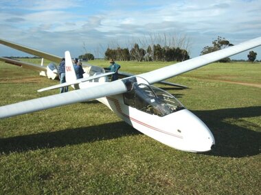
Machine - Glider – Sailplane, March 1964
The Schleicher K7 is a high wing tandem two-seat sailplane designed in the late 1950s by Rudolf Kaiser for the Alexander Schleicher company in Germany. The fuselage is built using steel tube framing covered with fabric. The swept-forward cantilever wing is of wood and fabric construction with a single spar and a plywood covered leading edge “D” box for strength. The wing is equipped with Schempp-Hirth airbrakes. The K7 first flew in 1959. It is a versatile design that can be used for both basic and more advanced training of pilots. Over 500 were built. VH-GNX was manufactured in Germany and imported into Australia by Edmund Schneider Limited. It was test flown by them at Parafield Aerodrome, Adelaide, South Australia in March 1964. The original owner of VH-GNX was the Adelaide Soaring Club and it was maintained by Edmund Schneider Limited until May 1971. It appears that about this time it was transferred to the Gold Coast Soaring Club. In July 1974, after it had flown for an aggregate 3075 hours from 13919 flights, it was purchased by the Bundaberg Soaring Club. About 10 years later, it was acquired by the Bendigo Gliding Club. At that stage it had recorded over 4600 hours flying time from 21546 launches. When it was retired from service by the Bendigo Gliding Club in June 2006 due to age related defects the hours flown had reached 7259 from 31820 flights. It appears that the airframe has had a relatively trouble free life with only minor damage from storage / ground handling incidents, a heavy landing (January 1987) and a bird strike (January 2002). It was donated to the Museum in April 2007.This exhibit is an example of the Schleicher K7 two seat sailplane type.Two seat high wing glider sailplane finished in white with red detailing.Serial Number 7134, registered as VH-GNX. The registration appears on each side of the Fin / Rudder in red letteringaustralian gliding, glider, sailplane, schleicher, k7, schneider, adelaide soaring club, gold coast soaring club, bundaberg soaring club, bendigo gliding club -
 Wangaratta RSL Sub Branch
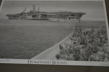
Framed print, HMAS Sydney, 2008
Depicting the boarding of Australian Troops from Vung Tau, Vietnam for return to Australia following active service in Vietnam. HMAS Sydney was a Majestic-class light aircraft carrier operated by the Royal Australian Navy (RAN). She was built for the Royal Navy and launched as HMS Terrible (93) in 1944, but was not completed before the end of World War II. The carrier was sold to Australia in 1947, completed, and commissioned into the RAN as Sydney in 1948. Sydney was the first of three conventional aircraft carriers to serve in the RAN, and operated as the navy's flagship during the early part of her career. From late 1951 to early 1952, she operated off the coast of Korea during the Korean War, making her the first carrier owned by a Commonwealth Dominion, and the only carrier in the RAN, to see wartime service. Retasked as a training vessel following the 1955 arrival of her modernised sister ship, HMAS Melbourne, Sydney remained in service until 1958, when she was placed in reserve as surplus to requirements. The need for a sealift capability saw the ship modified for service as a fast troop transport, and recommissioned in 1962. Sydney was initially used for training and a single supply run in support of Malaysia's defence policy against Indonesia, but in 1965, she sailed on the first voyage to Vũng Tàu, transporting soldiers and equipment to serve in the Vietnam War. 25 voyages to Vietnam were made between 1965 and 1972, earning the ship the nickname "Vung Tau Ferry". Sydney was decommissioned in 1973, and was not replaced. Despite several plans to preserve all or part of the ship as a maritime museum, tourist attraction, or car park, the carrier was sold to a South Korean steel mill for scrapping in 1975A pictorial image of troops returning to Australia from Vietnam.Timber frame with mount containing print of ship at sea and soldiers in a barge in foreground.Homeward Boundhmas sydney, ran -
 Wodonga & District Historical Society Inc
Photograph - Bethanga Bridge
The Bethanga Bridge was built between 1927 and 1930 as a joint venture between Victoria and New South Wales and was a key element of the River Murray Waters Agreement. It consists of nine spans of 82 metres long. Each span is supported between double reinforced concrete pylons and a riveted steel camel back Pratt truss. The overall span of the bridge is a length of 752 metres. It was completed in 1929 at a cost of £194,000. The road deck was initially constructed from timber but was replaced in 1961 with a concrete waffle slab deck 7.7metres wide. In 1961 the bridge deck and truss structure were raised 300 millimetres to allow for the enlargement of the lake. The bridge was designed in NSW by road engineer Percy Alan and the trusses were built by the Charles Ruwolt Pty. Ltd. Charles Ruwolt Pty. Ltd. was originally established by Charles Ruwolt as a foundry at Wangaratta in 1902 and transferred its operations to Richmond, Melbourne in 1914. By 1938 it had become one of the biggest engineering companies in Australia. After Charles Ruwolt’s death in 1946, Vickers Ltd. acquired the company and in 1948 the firm became known as Vickers Ruwolt Pty. Ltd. Because of the Bethanga Bridge’s unique location, over the waters of a dam with the border running down the centre of the body of water, the Bethanga Bridge is the only built structure shared by both Victoria and New South Wales. As the border of New South Wales aligns with the southern bank of the Murray River all of the other bridges along its length are deemed to be in New South Wales. The Bethanga Bridge is listed on both the New South Wales State Heritage Register and the Victorian Heritage Database. In 2015 the Bethanga Bridge was nominated for a heritage award by the Institution of Engineering Australia.These images are significant because they document the construction of a bridge which links Victoria and New South Wales and has been recognised for its historical, technical and engineering significance.A collection of photos documenting the construction of the Bethanga Bridge which links the States of Victoria and New South Wales as part of the construction of the Hume Dam .bethanga bridge, hume dam constuction, charles ruwolt, percy allan engineer -
 Phillip Island and District Historical Society Inc.
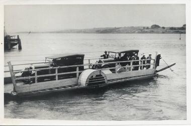
Photograph, Country Roads Board, 1960's
Nine photographs from the Country Roads Boards with Negative Numbers and description. Donated by L. J. HaywardNine photographs of the 2 car Punt and the 2 bridges between San Remo and Phillip Island. 310-01. Photograph of the two car punt operating in 1929 between San Remo and Newhaven. 310-02. Photograph of the Suspension Bridge between San Remo and Newhaven. 310-03. Photograph of the two bridges - old and new. 310-04. Photograph of the construction of the new bridge. 310-05 to 09. Photographs of the construction of the new bridge.310-01. CRB Neg No 68-1091 310-02. CRB Vic. Aust. Neg No. 61-864C 310.03. CRB Neg No. 69-1406 310-04. CRB Neg No. 67-3741 Phillip Island Bridge Sheet Pile Coffer Dam. 310-05. CRB Neg No. 68-461A. Phillip Island Bridge Portal Frame Piers on San Remo side. 310-06. CRB Neg No. 66-1012B Phillip island Bridge. The temporary steel bridge in October 1966. 310-07. CRB Neg No. 67-4019C Phillip Island Bridge. Anchor span beam 204 ft long. 310-08. CRB Neg No. 67-1826E. Phillip Island Bridge. Stressing an anchor span beam. 310-09. CRB Neg No. 67-1930F. Phillip Island Bridge. Placing the first beam on No. 3. span.suspension bridge, phillip island bridge, newhaven-san remo punt, l j hayward -
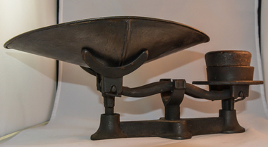 Kiewa Valley Historical Society
Scales Weighing, early 1900's
Although these scales cannot be identified against a historical period of Australian development they are therefore placed in a time frame when commercial markings from manufacurers were not important enough to have domestic kitchen items labeled. These cast iron scales were made for domestic and possibly rural areas and not for cities where demand for known branded utensils was more an issue. These scales are very "basic" and not to the level of weighing detail that commercial scales had to be at. These scales do not show any visible markers for accurate measurement. The "near enough is good enough" principle can be related to these scales.These scales are significant as they identify one of the basic preparation items for the weighing of foodstuff before the televising of "cooking" shows (1960s onward). The meals for which quantity measurements are required for domestic cooking is not exact however the use of cup measurements for large dishes is tedious and these scales offer the capacity for a larger mixture and an easier method for the "cook". As the need for accurate measurements of ingrediants for rural domestic meals has in the past been not been critical the requirement of accuracy that these scales do not provide is of no consequence. Domestic kitchens in the Kiewa Valley and the type of meals produced would not have required the accuracy of ingrediants that "modern " international cuisines of the later 1900's require. These kitchen scale were used whenrecipes had the terms "pinch, dollop, squidge and smidgen" were about as accurate as most recipes needed to be.Black cast iron, medium weighing scales, with a two arm cradle. On one side of the cradle is a two half circle holding frame for the retention of the metal container scoop. This light weight steel scoop/dish allows for the weighing of loose grain or similar type material to be contained and held in place for establish its saleable contents. On the other side of the weighing cradle is a flat circular platform to hold various metal disc. All the disks used on this platform have their weight stamped on them. When the produced filled in the scoop balances with the metal weight on the opposite end of the balance match (visual horizontal appraisal) the appropriate quantity required is obtained. This scale does not have any visual markings on the arms to identify a true balance. It is therefore reasonable to assume that these scales were for domestic use only and not for commercial transactions. There are two weights that are useable with these scales, one is stamped "1 lB"(pound) and one stamped "1" and both are made as a solid round piece of cast metal.The smaller disc has a "1 lb" moulded and pressed form within a marked inner circle and a mouled ridge outer circle enclosure. The other weight is slightly larger and has a moulded "1" located on the top within a raised circular edge.domestic kitchen scales, weighing scales, metal scales -
 Ballarat Tramway Museum
Photograph - Black & White Photograph/s - set of 9, Dave Macartney, Jan. 1986
Series of B&W photos of the interior and some exterior lettering and lining of Horse tram No. 1 showing the as received condition of the tramcar body. 790.1 - end panel bulkhead and cut hole through the roof where a cupboard was placed - see also item 766 for other details of the By-Laws signs. 790.2 - photo of tramcar side showing the outline through the paint of the tram car number - "1" 790.3 - Interior photo showing detail of framing around the By-Laws signs - see 766. 790.4 - interior detail where roof and end bulkhead meet. 790.5 - Exterior - showing some details of the lining. 790.6 - Exterior - showing locations of lettering along the base of the sides - have been outlined with a heavy line to show layout of lettering. 790.7 - as above but close up of "LLAA" 790.8 - similar to 790.4, but closer up. 790.9 - Exterior - view of one of the bottom corners of the body, showing the steel framing and the lining through the paint.trams, tramways, horse trams, btps, reconstruction, tramcars , tram 1 -
 Melbourne Tram Museum
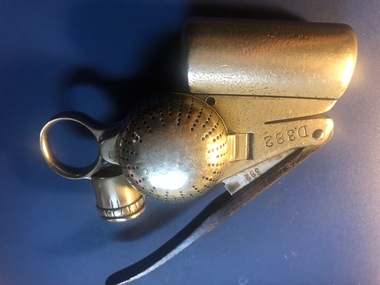
Functional object - Ticket punch, Railway Register Manufacturing Company?, Melbourne Tramway & Omnibus Co. Bell Punch, MID 1880S
Melbourne Tramway & Omnibus Co. Bell Punch No. D382. A heavy nickel plated steel ticket or fare strip cancelling / registering mechanism used on Melbourne cable trams. When a fare was sold, the bell would ring advising the passenger that their fare have registered. "An ingenious device resembling in principle the ticket punch of a railway porter. It is carried by the conductor who wears pinned to his coat a 'trip-slip'. He punches this once for every fare received; the action is simultaneously registered on a dial inside the punch and bell rings to appraise the passenger of the fact. The punch is provided with a patent lock, the secret of which is known only at headquarters and effective system of check is thus secured." (" A story of the Melbourne Cable Tramway System" - page 54). Used by the MT&O and MMTB until 1922/23 when replaced by the check ticket system. Manufactured by the Railway Register Manufacturing Company. Lock code IDMA. Has "MT&O Co. ..." stamped on one side along with patent dates.Has "D 382" punched above ticket entry slot (both sides), "335" on handle, "MT&O Co." stamped on numbering registering face.trams, tramways, ticket punch, bell punch, tickets, fares, cable trams -
 Bendigo Historical Society Inc.
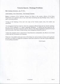
Document - DRAINAGE PROBLEMS - NEW CHUM MINES THE DRAINAGE QUESTION
Handwritten extract from the Bendigo Advertiser Jan 2nd 1911. ''In absence of Mr McBride, Minister for Mines in the country, officers of the Mines Department were inclined to-day to say much about unwatering the deep Bendigo mines, which is again a pressing problem. Owing to the breaking of the steel wire rope at the victoria Quartz mine, the trouble was intensified. An arrangement had been made by which the companies affected along the line should contribute, but two of the companies, it is stated, suspended operations. A scheme has been placed by Mr Stanfield before the parties interested, and the officers of the Mines Department expressed the hope that for the sake of the future of deep mining, some arrangement should be come to. Unless the companies show a disposition to help themselves substantially, the officers do not think it likely that the Government will co-operate. There are, it was added certain provisions of the Mines Act, and covenants in leases can be enforced, but there is no desire to compel the companies which have carried on in the face of great difficulties, to do anything reasonable.'' Albert Richardson Mining History Collectiongold, drainage problems, drainage problems, new chum mines the drainage question, bendigo advertiser 2/1/1911, mr mcbride, mines department, victoria quartz mine, mr stanfield, mines act, albert richardson. -
 Bendigo Historical Society Inc.
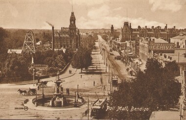
Photograph - PALL MALL, BENDIGO, c1903-1918
Two identical post cards: 'Pall Mall', Bendigo streetscape, fountain in foreground, horse-drawn cab, cable trams, Hustler's Royal Reserve Mine, Post Office, Henderson & Goodisson Beehive sign clearly visible. Physical description: loose photograph, sepia. Inscriptions markings: on back of photo - The 'Valentine & Sons' Publishing Co., Ltd., Melbourne. POST CARD. Printed in Great Britain. This space to be used for communication. The Address only to be written here. On front - Pall Mall, Bendigo. Also 300.336 then the letters JK in a circle. On back of the second postcard: Royal Historical Society of Victoria, Bendigo Branch. Hustlers Royal Reserve No.2 data. Hustlers Royal, Pall Mall, Bendigo. RSL Memorial Hall now occupies site. Depth of Shaft - 1,660 feet. Formed 1885; Closed 1917. Poppet Legs - Steel, 60 feet high. Winding engine: First motion, 24 in. Cylinders, 10ft. Drums. Gold yields - 10,262 oz. Dividends 3,200 pounds.The Valentine & Sons' Publishing Co., Ltd., Melbournebendigo, pall mall, rhsv, hustlers royal reserve -
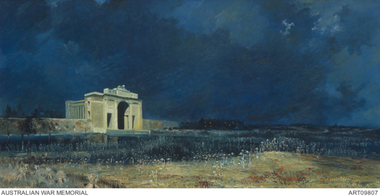 The 5th/6th Battalion Royal Victoria Regiment Historical Collection
Print - Reproduction, framed, The Menin Gate at Midnight
'Menin Gate at midnight' was painted by Will Longstaff to commemorate those soldiers with no marked graves on the Western Front during the First World War; also known as 'Ghosts of Menin Gate'. Longstaff attended a ceremony dedicating the Menin Gate memorial to the soldiers of the British empire forces, just outside the town of Ypres, Belgium, on 24 July 1927. The memorial was dedicated to the 350,000 men of the British and Empire forces who had died in battles around Ypres, and bears the names of 55,000 men with no known grave, over 6,000 of whom were Australians. Longstaff was profoundly moved by what he witnessed and that night, unable to sleep, Longstaff returned to Menin Road and later claimed to have had a vision of spirits of the dead rising out of the soil around him. On returning to his studio in London he painted 'Menin Gate at midnight' in a single session. Today 'Menin Gate at midnight' has achieved the status of a national icon. The painting retains its ability to provoke an emotional response and to communicate the scale of the loss of life and the devastation of war. However as people now have a very different understanding of war, the painting serves a slightly different function. Whereas in the past people responded to the painting as it related to the loss of a loved one and their own personal grief, now the painting communicates the loss experienced by a whole generation. The vast number of those who were killed, and the immensity of the damage wrought during the First World War, requires that those who sacrificed their lives should not be forgotten. Longstaff used well-known motifs to trigger emotion. His scarlet poppies are flowers that could be found in the Flanders fields, but they also carry the traditional connotations of shed blood and remembrance; they represent a floral blanket covering the bloodied bodies of unknown soldiers; at the same time, like the paper poppies worn on Remembrance Day, they are a tribute from the living to the dead. The portrayal of the steel-helmeted soldiers rising from the cornfields extends the range of visual emblems used by Longstaff: the plentiful harvest; the harvest of men; the steel-helmeted crosses covering the graves of many soldiers; and the helmeted bayonets raised in cheer and victory.ww1, menin gate, wark vc club -
 Eltham District Historical Society Inc
Photograph, Hume and Hovell passed here at Seymour 28 Oct 1824, Spring Excursion, Hume and Hovell's 1824 expedition (Part 2), 26 October 1997, 26/10/1997
[article by Diana Bassett-Smith in EDHS Newsletter No. 117, November 1997:] MONUMENT HUNTING THE HUME AND HOVELL WAY - Sunday October 26 1997 dawned bright and very warm. Some twenty-five members, complete with picnic baskets, met outside the Eltham Library awaiting the Cobb and Co. large coach which would be taking us on the second leg of our travels along the route of the early explorers Hume and Hovell. Stephen West was our very good driver for the day. He would be guided around the circuitous route by Russell Yeoman who had made a detailed study, not only of the intended route, but of the story of these two explorers. During the trip Russell regaled us with poetry, quotations from the Journals and the History of the Shire of Seymour, "The New Crossing Place" by Martindale, 1982, (now Mitchell Shire due to the recent amalgamations). We headed towards the Hume Highway via Greensborough and Cooper Street and proceeded north to our first stop, noting on the way Monument Hill in the distance which is near Kilmore and, according to Russell, well worth the effort to visit as the view across the valley is magnificent. Past Sunday Creek Valley, Mt Piper and Mt Disappointment, all traversed and noted and named by them. We passed through Tallarook, then onto Seymour where we took photos of the monument telling us that Hume and Hovell had passed through on the 28th of October 1824. We also deviated down Hume and Hovell Road viewing deer and emu farming and the Bellbourie property now a sanctuary. Leaving Seymour behind we travelled up the Avenel Road to the Avenel monument, pyramidal in design of four reducing square blocks with a sharply pointed peak, erected in 1924 in memory of the 1824 exploration. The day was warming up and the countryside showing the dryness of the current drought. A parallel note had been made in their journal too of 1824 of the drought appearance of the country they were traversing. At Seven Creeks, Euroa we stopped for some minutes to check the monument placed 20th November 1924 to commemorate their passage on the 29th December 1824. More photos. Russell had pointed out the abrupt termination of the distant ranges which is noted in their journal. The next monument is beside the road at the entrance to Honey Suckle Creek Caravan Park, Violet Town. The squarish shaped monument some eight feet high is topped with a simple steel cross, and was to mark the date of 28th December 1824 and built for the 20th November 1924. By now it was 12.20 and nearly lunchtime as we drove along the Warranbayne Road to Roach's Road, monument hunting without success. Though there is a large, what appears to be an old timber sign which was hard to read, maybe this was the lost monument. In many of the paddocks hay had been cut and baled or was being cut, what a contrast to the rugged country they had passed through which was smoky from the fires of the natives burning off. By 1.00 pm we were at Benalla and pulled up beside the park where abundant beds of roses filled the air with their scent and the smell of barbecued food twitched the nostrils whilst the cheerful sounds of other picnickers could be heard throughout the park. We left the bus and collected up our picnics, dispersed to the various tables and enjoyed the shade from the various European trees. 2.00 pm and we were on the road again driving along the Benalla, Mansfield, Yea road. The Swanpool monument states that they passed four miles south and returned three miles north. Then we stopped at the Barjarg monument which notes that they camped near this spot. It is again a pyramidal monument and this time topped with a steel arrow indicating their route of the 29th November 1824. Half an hour later we came to another monument, again with a steel arrow marker on top and the plaque dated the 2nd of 12th 1824. Erected on the 12th of 12th 1924. "They blazed the way that we might inherit the land." Another square based and needle topped monument appeared at Yarck near Yea and this plaque records the date of 3 December 1824. Near McGuigans Road Russell related that the expedition had lost a dog but it had found them next day, the dog was apparently torn by a kangaroo. A short while later Russell reminded us here of the problems they encountered in crossing the Goulburn River near Molesworth where banks were high, water deep and wide. "Good coat of grass but quite dry due to drought". At Yea we stopped for afternoon tea and raided the last of our picnics and looked at the monument to their journey of 1824, situated at a corner of the gardens near the bowling green. No photo – we were out of film. We returned home via Kinglake West and Whittlesea past the Yan Yean Reservoir, not full. 5.00 pm back at Eltham we emptied out of the bus and everyone, including Joan Cole, collected their things, Joan also had the major souvenir of the day, a large carp she had picked up from the river bank, her cat was in for a great feast. The day was made so interesting by the informed commentary which Russell provided. His background knowledge of the route and nature of the journey could only have come from many hours of reading and driving the area. Thank you to Russell and to everyone who made the day so informative and pleasurable. Colour photographactivities, hume and hovell, monument, seymour -
 Eltham District Historical Society Inc
Photograph, Spring Excursion, Hume and Hovell's 1824 expedition (Part 2), 26 October 1997, 26/10/1997
[article by Diana Bassett-Smith in EDHS Newsletter No. 117, November 1997:] MONUMENT HUNTING THE HUME AND HOVELL WAY - Sunday October 26 1997 dawned bright and very warm. Some twenty-five members, complete with picnic baskets, met outside the Eltham Library awaiting the Cobb and Co. large coach which would be taking us on the second leg of our travels along the route of the early explorers Hume and Hovell. Stephen West was our very good driver for the day. He would be guided around the circuitous route by Russell Yeoman who had made a detailed study, not only of the intended route, but of the story of these two explorers. During the trip Russell regaled us with poetry, quotations from the Journals and the History of the Shire of Seymour, "The New Crossing Place" by Martindale, 1982, (now Mitchell Shire due to the recent amalgamations). We headed towards the Hume Highway via Greensborough and Cooper Street and proceeded north to our first stop, noting on the way Monument Hill in the distance which is near Kilmore and, according to Russell, well worth the effort to visit as the view across the valley is magnificent. Past Sunday Creek Valley, Mt Piper and Mt Disappointment, all traversed and noted and named by them. We passed through Tallarook, then onto Seymour where we took photos of the monument telling us that Hume and Hovell had passed through on the 28th of October 1824. We also deviated down Hume and Hovell Road viewing deer and emu farming and the Bellbourie property now a sanctuary. Leaving Seymour behind we travelled up the Avenel Road to the Avenel monument, pyramidal in design of four reducing square blocks with a sharply pointed peak, erected in 1924 in memory of the 1824 exploration. The day was warming up and the countryside showing the dryness of the current drought. A parallel note had been made in their journal too of 1824 of the drought appearance of the country they were traversing. At Seven Creeks, Euroa we stopped for some minutes to check the monument placed 20th November 1924 to commemorate their passage on the 29th December 1824. More photos. Russell had pointed out the abrupt termination of the distant ranges which is noted in their journal. The next monument is beside the road at the entrance to Honey Suckle Creek Caravan Park, Violet Town. The squarish shaped monument some eight feet high is topped with a simple steel cross, and was to mark the date of 28th December 1824 and built for the 20th November 1924. By now it was 12.20 and nearly lunchtime as we drove along the Warranbayne Road to Roach's Road, monument hunting without success. Though there is a large, what appears to be an old timber sign which was hard to read, maybe this was the lost monument. In many of the paddocks hay had been cut and baled or was being cut, what a contrast to the rugged country they had passed through which was smoky from the fires of the natives burning off. By 1.00 pm we were at Benalla and pulled up beside the park where abundant beds of roses filled the air with their scent and the smell of barbecued food twitched the nostrils whilst the cheerful sounds of other picnickers could be heard throughout the park. We left the bus and collected up our picnics, dispersed to the various tables and enjoyed the shade from the various European trees. 2.00 pm and we were on the road again driving along the Benalla, Mansfield, Yea road. The Swanpool monument states that they passed four miles south and returned three miles north. Then we stopped at the Barjarg monument which notes that they camped near this spot. It is again a pyramidal monument and this time topped with a steel arrow indicating their route of the 29th November 1824. Half an hour later we came to another monument, again with a steel arrow marker on top and the plaque dated the 2nd of 12th 1824. Erected on the 12th of 12th 1924. "They blazed the way that we might inherit the land." Another square based and needle topped monument appeared at Yarck near Yea and this plaque records the date of 3 December 1824. Near McGuigans Road Russell related that the expedition had lost a dog but it had found them next day, the dog was apparently torn by a kangaroo. A short while later Russell reminded us here of the problems they encountered in crossing the Goulburn River near Molesworth where banks were high, water deep and wide. "Good coat of grass but quite dry due to drought". At Yea we stopped for afternoon tea and raided the last of our picnics and looked at the monument to their journey of 1824, situated at a corner of the gardens near the bowling green. No photo – we were out of film. We returned home via Kinglake West and Whittlesea past the Yan Yean Reservoir, not full. 5.00 pm back at Eltham we emptied out of the bus and everyone, including Joan Cole, collected their things, Joan also had the major souvenir of the day, a large carp she had picked up from the river bank, her cat was in for a great feast. The day was made so interesting by the informed commentary which Russell provided. His background knowledge of the route and nature of the journey could only have come from many hours of reading and driving the area. Thank you to Russell and to everyone who made the day so informative and pleasurable. Colour photographactivities, hume and hovell, bridge -
 Eltham District Historical Society Inc
Photograph, Spring Excursion, Hume and Hovell bus tour Stage 2, Seymour, Benalla; 26 Oct 1997, 26/10/1997
MONUMENT HUNTING THE HUME AND HOVELL WAY (Newsletter No. 117, November 1997, by Diana Bassett-Smith) Sunday October 26 1997 dawned bright and very warm. Some twenty-five members, complete with picnic baskets, met outside the Eltham Library awaiting the Cobb and Co. large coach which would be taking us on the second leg of our travels along the route of the early explorers Hume and Hovell. Stephen West was our very good driver for the day. He would be guided around the circuitous route by Russell Yeoman wh9 had made a detailed study, not only of the intended route, but of the story of these two explorers. During the trip Russell regaled us with poetry, quotations from the Journals and the History of the Shire of Seymour, "The New Crossing Place: by Martindale, 1982, (now Mitchell Shire due to the recent amalgamations). We headed towards the Hume Highway via Greensborough and Cooper Street and proceeded north to our first stop, noting on the way Monument Hill in the distance which is near Kilmore and, according to Russell, well worth the effort to visit as the view across the valley is magnificent. Past Sunday Creek Valley, Mt Piper and Mt Disappointment, all traversed and noted and named by them. We passed through Tallarook, then onto Seymour where we took photos of the monument telling us that Hume and Hovell had passed through on the 28th of October 1824. We also deviated down Hume and Hovell Road viewing deer and emu farming and the Bellbourie property now a sanctuary. Leaving Seymour behind we travelled up the Avenel Road to the Avenel monument, pyramidal in design of four reducing square blocks with a sharply pointed peak, erected in 1924 in memory of the 1824 exploration. The day was warming up and the countryside showing the dryness of the current drought. A parallel note had been made in their journal too of 1824 of the drought appearance of the country they were traversing. At Seven Creeks, Euroa we stopped for some minutes to check the monument placed 20th November 1924 to commemorate their passage on the 29th December 1824. More photos. Russell had pointed out the abrupt termination of the distant ranges which is noted in their journal. The next monument is beside the road at the entrance to Honey Suckle Creek Caravan Park, Violet Town. The squarish shaped monument some eight feet high is topped with a simple steel cross, and was to mark the date of 28th December 1824 and built for the 20th November 1924. By now it was 12.20 and nearly lunchtime as we drove along the Warranbayne Road to Roach's Road, monument hunting without success. Though there is a large, what appears to be an old timber sign which was hard to read, maybe this was the lost monument. In many of the paddocks hay had been cut and baled or was being cut, what a contrast to the rugged country they had passed through which was smoky from the fires of the natives burning off By 1.00 pm we were at Benalla and pulled up beside the park where abundant beds of roses filled the air with their scent and the smell of barbecued food twitched the nostrils whilst the cheerful sounds of other picnickers could be heard throughout the park. We left the bus and collected up our picnics, dispersed to the various tables and enjoyed the shade from the various European trees. 2.00 pm and we were on the road again driving along the Benalla, Mansfield, Yea road. The Swanpool monument states that they passed four miles south and returned three miles north. Then we stopped at the Barjarg monument which notes that they camped near this spot. It is again a pyramidal monument and this time topped with a steel arrow indicating their route of the 29th November 1824. Half an hour later we came to another monument, again with a steel arrow marker on top and the plaque dated the 2nd of 12th 1824. Erected on the 12th of 12th 1924. "They blazed the way that we might inherit the land." Another square based and needle topped monument appeared at Yarck near Yea and this plaque records the date of 3 December 1824. Near McGuigans Road Russell related that the expedition had lost a dog but it had found them next day, the dog was apparently torn by a kangaroo. A short while later Russell reminded us here of the problems they encountered in crossing the Goulburn River near Molesworth where banks were high, water deep and wide. "Good coat of grass but quite dry due to drought". At Yea we stopped for afternoon tea and raided the last of our picnics and looked at the monument to their journey of 1824, situated at a corner of the gardens near the bowling green. No photo – we were out of film. We returned home via Kinglake West and Whittlesea past the Yan Yean Reservoir, not full. 5.00 pm back at Eltham we emptied out of the bus and everyone, including Joan Cole, collected their things, Joan also had the major souvenir of the day, a large carp she had picked up from the river bank, her cat was in for a great feast. The day was made so interesting by the informed commentary which Russell provided. His background knowledge of the route and nature of the journey could only have come from many hours of reading and driving the area. Thank you to Russell and to everyone who made the day so informative and pleasurable. Diana Bassett-Smith. Record of the Society's history of activities - Spring 1997 excursionRoll of 35mm colour negative film, 6 stripsFuji 200shire of eltham historical society, activities, pretty hill, seymour, benalla, hume and hovell, monuments -
 Eltham District Historical Society Inc
Photograph, Spring Excursion, Hume and Hovell bus tour Stage 2, Seymour, Benalla; 26 Oct 1997, 26/10/1997
MONUMENT HUNTING THE HUME AND HOVELL WAY (Newsletter No. 117, November 1997, by Diana Bassett-Smith) Sunday October 26 1997 dawned bright and very warm. Some twenty-five members, complete with picnic baskets, met outside the Eltham Library awaiting the Cobb and Co. large coach which would be taking us on the second leg of our travels along the route of the early explorers Hume and Hovell. Stephen West was our very good driver for the day. He would be guided around the circuitous route by Russell Yeoman wh9 had made a detailed study, not only of the intended route, but of the story of these two explorers. During the trip Russell regaled us with poetry, quotations from the Journals and the History of the Shire of Seymour, "The New Crossing Place: by Martindale, 1982, (now Mitchell Shire due to the recent amalgamations). We headed towards the Hume Highway via Greensborough and Cooper Street and proceeded north to our first stop, noting on the way Monument Hill in the distance which is near Kilmore and, according to Russell, well worth the effort to visit as the view across the valley is magnificent. Past Sunday Creek Valley, Mt Piper and Mt Disappointment, all traversed and noted and named by them. We passed through Tallarook, then onto Seymour where we took photos of the monument telling us that Hume and Hovell had passed through on the 28th of October 1824. We also deviated down Hume and Hovell Road viewing deer and emu farming and the Bellbourie property now a sanctuary. Leaving Seymour behind we travelled up the Avenel Road to the Avenel monument, pyramidal in design of four reducing square blocks with a sharply pointed peak, erected in 1924 in memory of the 1824 exploration. The day was warming up and the countryside showing the dryness of the current drought. A parallel note had been made in their journal too of 1824 of the drought appearance of the country they were traversing. At Seven Creeks, Euroa we stopped for some minutes to check the monument placed 20th November 1924 to commemorate their passage on the 29th December 1824. More photos. Russell had pointed out the abrupt termination of the distant ranges which is noted in their journal. The next monument is beside the road at the entrance to Honey Suckle Creek Caravan Park, Violet Town. The squarish shaped monument some eight feet high is topped with a simple steel cross, and was to mark the date of 28th December 1824 and built for the 20th November 1924. By now it was 12.20 and nearly lunchtime as we drove along the Warranbayne Road to Roach's Road, monument hunting without success. Though there is a large, what appears to be an old timber sign which was hard to read, maybe this was the lost monument. In many of the paddocks hay had been cut and baled or was being cut, what a contrast to the rugged country they had passed through which was smoky from the fires of the natives burning off By 1.00 pm we were at Benalla and pulled up beside the park where abundant beds of roses filled the air with their scent and the smell of barbecued food twitched the nostrils whilst the cheerful sounds of other picnickers could be heard throughout the park. We left the bus and collected up our picnics, dispersed to the various tables and enjoyed the shade from the various European trees. 2.00 pm and we were on the road again driving along the Benalla, Mansfield, Yea road. The Swanpool monument states that they passed four miles south and returned three miles north. Then we stopped at the Barjarg monument which notes that they camped near this spot. It is again a pyramidal monument and this time topped with a steel arrow indicating their route of the 29th November 1824. Half an hour later we came to another monument, again with a steel arrow marker on top and the plaque dated the 2nd of 12th 1824. Erected on the 12th of 12th 1924. "They blazed the way that we might inherit the land." Another square based and needle topped monument appeared at Yarck near Yea and this plaque records the date of 3 December 1824. Near McGuigans Road Russell related that the expedition had lost a dog but it had found them next day, the dog was apparently torn by a kangaroo. A short while later Russell reminded us here of the problems they encountered in crossing the Goulburn River near Molesworth where banks were high, water deep and wide. "Good coat of grass but quite dry due to drought". At Yea we stopped for afternoon tea and raided the last of our picnics and looked at the monument to their journey of 1824, situated at a corner of the gardens near the bowling green. No photo – we were out of film. We returned home via Kinglake West and Whittlesea past the Yan Yean Reservoir, not full. 5.00 pm back at Eltham we emptied out of the bus and everyone, including Joan Cole, collected their things, Joan also had the major souvenir of the day, a large carp she had picked up from the river bank, her cat was in for a great feast. The day was made so interesting by the informed commentary which Russell provided. His background knowledge of the route and nature of the journey could only have come from many hours of reading and driving the area. Thank you to Russell and to everyone who made the day so informative and pleasurable. Diana Bassett-Smith. Record of the Society's history of activities - Spring 1997 excursionRoll of 35mm colour negative film, 6 stripsFuji 200shire of eltham historical society, activities, pretty hill, seymour, benalla, hume and hovell, monuments