Showing 25665 items
matching plenty-township-estate
-
 Greensborough Historical Society
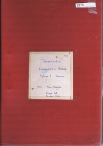
Folder, Ann Douglas, Greenbelts, 1973_
Includes much information of the condition of the Plenty River, and its cleanup by the Plenty River Action Committee, a group of students at Watsonia Technical School. Includes interview on audio tape which have been transcribed.Looseleaf folder containing handwritten report, miscellaneous documents, col. photographs and 2 audiotapes (see Word doc for transcript of audio tapes)plenty river, plenty river action committee, david wilkinson -
 Bacchus Marsh & District Historical Society
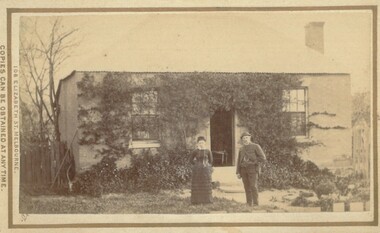
Photograph, Cottage Bacchus Marsh 1883
The precise location of this house and the identity of the two people in the picture has not been established. It is possible it is a house within the township area of Bacchus Marsh. The image only includes the house and the garden area and does not depict any surrounding farm land or farmyard buildings indicating a probable township location.Small sepia unframed photograph on card with gold border framing photograph. Housed in the album, 'Photographs of Bacchus Marsh and District in 1883 by Stevenson and McNicoll'. The image depicts a house with a man and a woman standing in front of it. The house has a well-established creeper present across much of the front of the house indicating it had been occupied for some time when this photograph was taken.On the front: Stevenson & McNicoll. Photo. 108 Elizabeth St. Melbourne. COPIES CAN BE OBTAINED AT ANY TIME. On the back: LIGHT & TRUTH inscribed on a banner surmounted by a representation of the rising sun. Copies of this Portrait can be had at any time by sending the Name and Post Office Money Order or Stamps for the amount of order to STEVENSON & McNICOLL LATE BENSON & STEVENSON, Photographers. 108 Elizabeth Street, MELBOURNE stevenson and mcnicoll 1883 photographs of bacchus marsh and district, houses bacchus marsh -
 Marysville & District Historical Society
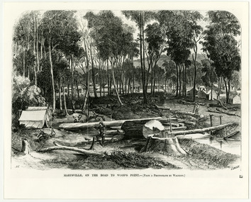
Work on paper (item) - Print of wood engraving, Frederick Grosse et al, Marysville, on the road to Wood's Point, 27-11-1866
A copy of an early wood engraving taken from a photograph of the township of Marysville in Victoria.A copy of an early wood engraving taken from a photograph of the township of Marysville in Victoria. The Yarra Track is the former name of the gold fields road from Healesville to the Woods Point and Jordan Goldfields in Victoria.victoria, frederick grosse, albert charles cooke, thomas waters, wood engraving, marysville, wood's point road -
 Lakes Entrance Regional Historical Society (operating as Lakes Entrance History Centre & Museum)
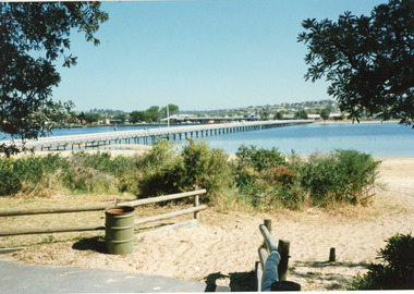
Photograph, 1999c
This photo taken from south side (looking towards township on northern side)Colored photograph of the footbridge over the Cunninghame Arm, taken from the path on the southern shore. It shows sand, scrub, treated pine fences and rubbish bin, town in the distance on northern shore. Lakes Entrance Victoriawaterfront, topography, bridges -
 Bendigo Military Museum
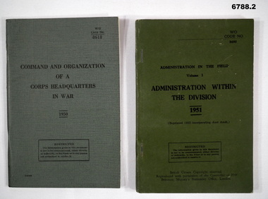
Manual - MANUALS, ADMINISTRATION, British War Office, 1950 - 1951
Items in the collection re Lt Col J. Swatton, refer Cat No 6719.2P for his service details.1. This is a green buckram covered pocket book. Printing on front cover is in black ink. Inside are 71 pages of organisations and diagrams of HQ areas. It is fastened with two staples. 2. This is a green cardboard covered book. Front cover is printed in black ink. It shows the interconnection of various elements within the division. Dated 1951.1. On rear cover is a sticky label. Words are:- " On loan from the Estate of Colonel J. W. Swatton Ref No. JWS M22". 2. On the rear is a sticky label. It has the words " On loan from the Estate of Colonel J.W. Swatton Ref JWS M23" passchendaele barracks trust, army organisation, administration, j.w. swatton -
 Warrnambool and District Historical Society Inc.
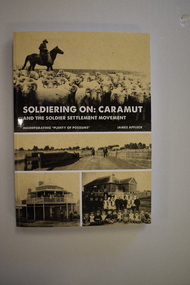
Book, StarPrinting Service Pty ltd, Soldiering On – Caramut and the Soldier Settler Movement, 2018
This book records the history of the post World War Two soldier settlement farms in the Caramut area. Number two in a series of books on Soldier Settlements in Western Victoria.This is a soft cover book of 315 pages. It has a buff-coloured cover with black and white photographs and white printing on the front cover and black printing on the spine. The book includes printed material, black and white photographs, maps and plans. non-fiction This book records the history of the post World War Two soldier settlement farms in the Caramut area. Number two in a series of books on Soldier Settlements in Western Victoria.james affleck, peterborough, soldier settlement, caramut, history of warrnambool, soldier settlement, caramut -
 Flagstaff Hill Maritime Museum and Village
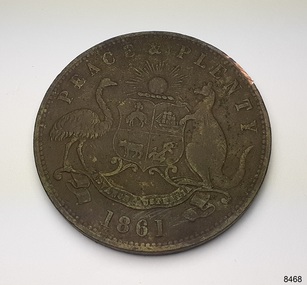
Currency - Coin, Robert Hyde & Co. Shipping Merchants, 1861
The donor (a local resident.) of this coin found this penny token coin in the sand dunes of Lady Bay, Warrnambool, in 2023. The coin could have come from a local shipwreck, passengers, or members of the community. Trade was carried out along the southwest coast of Victoria between Melbourne and Portland, with the Port of Warrnambool receiving passengers and goods by coastal traders, the steamboat that set off from ports every few days. One such vessel was the steamship SS Edina that made her first voyage from Melbourne to Portland in 1863. For around a decade or so in the Gold Rush period in Australia there was a shortage of official government currency. It was acceptable during this time to use token coins minted by local businesses to be used within their store, much like the loyalty and rewards cards that businesses give their customers in modern times. The tokens were also a good way to advertise their wares and details. The first token was introduced in Melbourne in 1848 and were used until 1868, when they became illegal in New South Wales. They were minted in Australia and overseas. The token was issued by Robert Hyde & Co. who traded in second-hand goods such as old clothes, sheets, metal items and glass, which they resold to be re-manufactured, or "recycled".A token such as this one identifies businesses existing in the post-Gold Rush period in Australia. Round copper coin. Penny token coin bearing the Australian Coat of Arms and motto. The coin also has the company's name, location, nature of business and motto. The coin has grooves around the edge. It was made in 1861.OBVERSE: Logo: (Australian Coat of Arms), Motto: "PEACE & PLENTY", Date: 1861 REVERSE: "ROBERT HYDE & CO MELBOURNE", "GENERAL MARINE STORE, SHIPPERS OF RAGS GLASS METALS &.C"flagstaff hill maritime museum and village, warrnambool, great ocean road, shipwreck coast, merchant token, melbourne, token, australian token, trade token, coins, merchants, medal, colonisation, gold rush, robert hyde & co., general marine store, shippers of rags glass metals etc., numismatics, second-hand scrap, scrap goods -
 Queenscliffe Maritime Museum
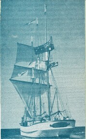
Photograph - 1986-060.1 - Alma Doepel under sail / 1986-060.2 National Trust article / 1986-060.3 G'long Independent article / 1986-060.4 Bellarine Echo article, Photograph & news articles, 06/06/1989
This three masted Cutter was built in AustraliaAustralian tall ship1986-060.1 Photograph of the Alma Doepel under sail in Port Phillip 1986-060.2 National Trust article re the Alma Doepel, March 1986 1986-060.3 Geelong Independent article 9 June 1989 1986-060.4 Bellarine Echo article 02Feb 1988 re Alma Doepel1986-060.1 - On the reverse: "A. D. S. C. 142 Old Eltham Rd Lower Plenty 3093" 1986-060.2 - Alcoa advertisement 1986-060.3 - NIL 1986-060.4 - NIL1986-060.1 to 4 merchant ship, 1986-060.2 historical information, 1986-060.3 alma doepel & victor (tug), 1986-060.4 alma doepel misses the fleet -
 Greensborough Historical Society
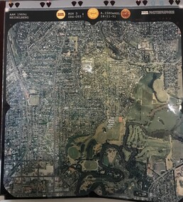
Aerial Photograph, AAM Photographics, Heidelberg AAM1969c 106, 24/11/1991
One of an overlapping series of aerial photographs of the Heidelberg/Greensborough areas in 1991, covering the Simpson Barracks, Greensborough & Viewbank. North boundary Nell Street, East boundary Plenty River, South boundary Lower Plenty Road.Laminated colour aerial photographsimpson barracks, greensborough, viewbank -
 Eltham District Historical Society Inc
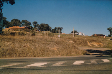
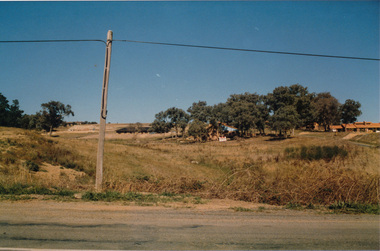
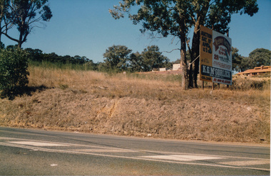
Photograph, Peter Bassett-Smith, Former Brinkkotter Poultry Farm, Main Road, Research, April 1988, 1988
Four colour photographs of the former Brinkkotter Poultry Farm, Main Road, Research depicting the 'Regency Acres' real estate development of 22 lots advertised for auction 19 April 1988. The four photographs are shot by Peter Bassett-Smith in a panoramic sweep of the estate from Eltham College to the Research Primary School.poultry farm, main road, research vic., brinkkotter -
 Eltham District Historical Society Inc
Photograph, Peter Bassett-Smith, Former Brinkkotter Poultry Farm, Main Road, Research, April 1988, 1988
Four colour photographs of the former Brinkkotter Poultry Farm, Main Road, Research depicting the 'Regency Acres' real estate development of 22 lots advertised for auction 19 April 1988. The four photographs are shot by Peter Bassett-Smith in a panoramic sweep of the estate from Eltham College to the Research Primary School.poultry farm, main road, research vic., brinkkotter -
 Greensborough Historical Society
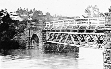
Photograph - Digital Image, River's up on Greensborough Bridge, 1910c
Plenty River in flood at old Greensborough bridge.Digital copy of black and white photograph.plenty river, floods -
 Greensborough Historical Society
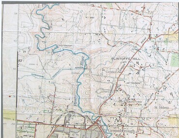
Map, John Monash, 1913 Map of Greensborough, 1913
1913 Map of Greensborough, possibly by John Monash. This map shows the area to the north of the township.Map, colour.greensborough - maps, 1913 -
 Greensborough Historical Society
Article, Printer Unknown, Greensborough, 1840o
Details the history of the current Greensborough township. It also mentions the early settlement of Kangaroo Point.Mentions early settlers such as William Poulter, James Chapman, James Mann and Edwin Willis Magger (Maygar).2 page printed document outlining the activities and motives of Edward Bernard Green, an early owner of the area of land that became Greensborough.Pencilled words on front page. greensborough, kangaroo point, edward green, poulter, mann, chapman, magger, mayger, melbourne to sydney mail contract -
 Halls Gap & Grampians Historical Society
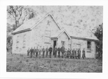
Photograph - B/W, C 1878-1888
This school was moved to Heatherlie Township from Darra in 1888. Closed in 1890 and moved to BeulahTeacher and students outside School House Historical Places Branch,education, schools, heatherlie -
 Tatura Irrigation & Wartime Camps Museum
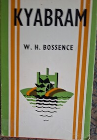
Book, Kyabram, 1965
Written history of the township of Kyabram, covering squatters, the reform movement, churches, hospitals etc.Red hard cover. Cover design by Anne Bossence. Dust jacket green, white and brown. Title and author in black print. Drawing of a water wheel in green and brown. Back cover whitebossence w, kyabram, kyabram reform movement, kyabram churches, kyabram hospitals, kyabram squatters -
 Tatura Irrigation & Wartime Camps Museum
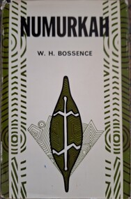
Book, Numurkah, 1965
Written history of the township of Numurkah, covering squatters, the aboriginals, churches, hospitals, railways etc.Black hard cover. Cover design by Anne Bossence. Dust jacket green, white and brown. Title and author in black print. Sketch on front is of an aboriginal drawing depicting a leaf with an animal on it in green. Back cover whitebossence w, numurkah, numurkah squatters, numurkah aboriginals, numurkah churches, numurkah hospitals -
 Stawell Historical Society Inc
Map, Plan of Division Line between Ararat and Stawell Shires 1877, 1877
Grampians Halls Gap Black Range Stawell Shire Ararat Shire Crowlands TownshipVery Large Map Printed on Linen with Table of bearingsExamined by H.C. Malcolm 28.12.77 Traced By D.H. Meike 28.12.77survey -
 Federation University Historical Collection
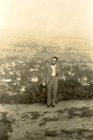
Photograph, Frank Wright on Beacon Hill, Great Malvern, 1934, 05/07/1934
Frank Wright was a renown resident of Smeaton, where he was born. He lived at Laura Villa, and attended Smeaton State School. His father William was a gold miner and his mother's name was Sarah. Their family won many singing and instrumental awards. Frank was tutored by Percy Code and was awarded a gold medal for the highest marks in the ALCM examinations in the British Colonies at the age of seventeen years. He became the Australian Open Cornet Champion by the age of eighteen. A year later, Frank conducted the City of Ballarat Band, and later the Ballarat Soldiers’ Memorial Band. He formed the Frank Wright Frisco Band and Frank Wright and his Coliseum Orchestra. These bands won many South Street awards, and Frank as conductor won many awards in the Australian Band Championship contest. In 1933 Frank Wright sailed to England to conduct the famous St Hilda’s Band and was later appointed Musical Director of the London County Council, where he organized many amazing concerts in parks, in and around the London district. He was made Professor of Brass and Military Band Scoring and conducted at the Guildhall of Music and Drama. Frank was often invited to adjudicate Brass Band Championships around Europe, in Australia, including South Street and in New Zealand. The Frank Wright Medal at the Royal South Street competition is awarded to an individual recognized as making an outstanding contribution to brass music in Australia.Black and white photograph of a man dressed in a suit and standing in a cleared area on a hill with small shrubbery behind and then the far background is made up of a township and fields. The man is Frank Wright and the place is Beacon Hill overlooking Great Malvern.Written in pencil on the back - Au, Frank Wright on Beacon Hill, Great Malvern, 5.7.34frank wright, conductor, beacon hill, great malvern -
Bendigo Historical Society Inc.
Map - STRATHFIELDSAYE, See above
Map: Township of Strathfieldsaye, Group of 4 plans, 2 hand drafted and 2 printed. Applied to canvas and stapled to the backing. The printed plans are dated January 1859 and 6th January 1871 (number 267 in map cupboard 1)map, bendigo, township, strathfieldsaye -
Lakes Entrance Regional Historical Society (operating as Lakes Entrance History Centre & Museum)
Book, McMahon, David and Fitzclarence, Eunice, This Bold Venture. The Story of Lake Tyers House Place and People, 2009
An edited account of the diary of Robert Hamilton McMahon written 1917-1918, when he served as 'milkman' for the township of Lakes Entrance and associated settlements, from his dairy herd on Rigby Island and the Barrier, Gippsland Lakes, Victoria.township, land settlement -
Clunes Museum
Document - EXTRACT, CIRCA 1986
PHOTOCOPY EXTRACT FROM VICTORIAN GOVERNMENT GAZETTE PAGE 3973 NO. 86 - 15 OCTOBER 1986 REGARDING VESTING OF LAND IN THE MUNICIPALITY OF THE SHIRE OF TALBOT AND CLUNES. THAT BEING CROWN ALLOTMENT 34, SECTION C, PARISH AND TOWNSHIP OF CLUNESHANDWRITTEN IN PEN: CLU0066-01756 171/86local history, government, state government, shire of talbot and clunes -
 Lakes Entrance Regional Historical Society (operating as Lakes Entrance History Centre & Museum)
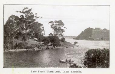
Photograph, 1920c
Copy same view but titled 'North Arm - Lakes Entrance' 11.5 x 18Black and white photograph of the North Arm. It shows the calm waters of the arm which twist and turn between high scrub covered banks. Distant view of township, two people in small boat in foreground. Lakes Entrance VictoriaLakes Scene North Arm Lakes Entrancevegetation, topography, waterways -
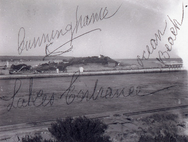 Lakes Entrance Regional Historical Society (operating as Lakes Entrance History Centre & Museum)
Photograph, 1920c
Black and white photograph showing entrance view from western pier towards eastern pier and works buildings, includes flagstaff rocket shed, township in distance, tramline along western pier in foreground, at Lakes Entrance, Victoria.waterways, jetties, ocean -
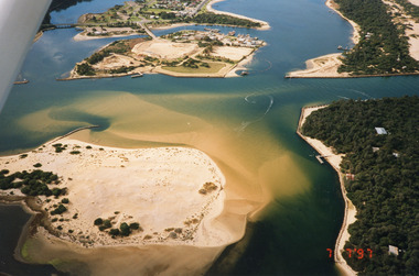 Lakes Entrance Regional Historical Society (operating as Lakes Entrance History Centre & Museum)
Photograph, 1997
Date made 7 July 1997Colour photograph being an aerial view of entrance at Lakes Entrance, showing the sand hummocks, the sand bar offshore a fishing boat entering the channel through the bar which appears to be recently dredged township of Lakes Entrance Victoriafishing industry, waterways, islands, boats and boating -
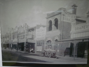 Glen Eira Historical Society
Historical Caulfield to 1972, photo album by Jenny O’Donnell, Glen Huntly Rd
2 photos of buildings circa 1910 with car, grocer, estate agent, BW tanks, 2 storey, ES&A bank, Draperyelsternwick, buildings, glen huntly rd estate agents, , es&a bank, , drapery, o’donnell, jenny -
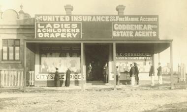 Ringwood and District Historical Society
Photograph, Shop formerly in Station St. corner Greenwood Ave (undated)
Signs read "The United Insurance Co Ltd Fire Marine Accident", "Ladies & Children's Drapery", "Godbehear & Co Estate Agents"Typed below photograph, 'Shop formerly in Station St. corner Greenwood Ave." -
Port Melbourne Historical & Preservation Society
Document - 2001 Calendar, Frank Gordon Estate Agents, c. 1920
Letterboxed in 2000Calendar for 2001 with colour-enhanced photo of Station Pier, steamers and the Ozone c1920, distributed by advertising estate agents Frank Gordonbusiness and traders, piers and wharves - station pier, frank gordon and co, real estate