Showing 10880 items
matching land
-
 Southern Sherbrooke Historical Society Inc.
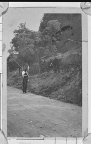
Photograph - Bill Hermon Snr and his bullock team
B&W photo of Bill Hermon Snr standing on a dirt road, wearing a hat, shirt, waistcoat and trousers, and holding a long bullocky's whip over his right shoulder. The land to the right of the photo rises steeply and is treed. Bill's bullock team is on a track or ledge about a metre above the road level. The first four animals can be seen. Photo dated 1913-1925. -
![Map, [Plan for road to give J. Allan access to permanent water at Coimadai] circa 1870s](/media/collectors/5e461d8021ea67224c82f2a1/items/67735190d671e67dd573a84c/item-media/6773533dd671e67dd573cd90/item-fit-380x285.jpg) Bacchus Marsh & District Historical Society
Bacchus Marsh & District Historical SocietyMap, [Plan for road to give J. Allan access to permanent water at Coimadai] circa 1870s
The date of this map or plan is uncertain but it appears to be from the early to mid 1870s. One of the landholders identified on the plan, James Allan of Coimadai died suddenly on the 9th July, 1874 (see Bacchus Marsh Express, 11 July, 1874, page. 3). There are mentions of an Allans Road at Coimadai in the Bacchus Marsh Express between 1887 and 1942.Single page map showing an excision of land belonging to Charles Ross which was selected to construct a road to give another landholder, J. Allan access to permanent water. Scale 1 chain to 1 inch. Part of a set of maps which are pasted into a bound volume containing 76 maps or plans in total. High resolution digital image stored on BMDHS computer network. Plan showing Excisions from Ross's selection and 1 chain road thro' the said selection in Coimadai to give J. Allan access to permanent water. Alistair ?? Shire Eng? 6?/5/7?coimadai victoria maps, coimadai roads and streets -
 Falls Creek Historical Society
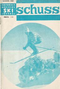
Journal - Schuss Vol. 26. No 6 August 1960
Schuss was advertised as Victoria’s Official Ski Journal It was issued monthly from 1935 to 1961 except during the war when summer issues covered two months. This continued after the war, but it averaged 10 issues annually over its 25 year life. Schuss was published by the Ski Club of Victoria which had a membership of 38 Ski Clubs and demanded to be recognised as the prime authority on skiing in the state. The other 30 ski clubs with 85% of the members disagreed and the politics of skiing became heated. These clubs formed the Federation of Victorian Ski Clubs with their own journal, Ski Horizon. With the establishment of the Victorian Ski Association, Ski-Horizon published its last issue in Nov - Dec. 1955 and the role of the official journal was fully taken over by “Schuss”. This item is significant because it contains stories, images and information documenting the development of the ski facilities at Falls Creek.The journal includes stories and events chronicling developments in Victoria and internationally. The cover features a photo of a downhill skier. Page 272 featured N.E.D.S.A notes contributed by Molly Bunyan. Page 292 carried an advertisement for the pre-selection sale for land in the Mt Beauty Estate. Ab short article on page 302 explained was now fully wired for electricity which should be connected in early August.schuss journal, skyline lodge, mount beauty estate, n.e.d.s.a. events at falls creek -
 Orbost & District Historical Society
map/poster, Victorian Government Printer, 22.4.1926
The Department of Crown Lands and Survey was originally established in 1857 as part of the Board of Land and Works. In 1964 it ceased to be controlled by the Board. The Department functioned for almost twenty more years before being combined with other Ministries to form the Department of Conservation, Forests and Land. It was responsible for the management of the State's Crown land and pastoral estates. This map was used by Don Mehlert after 1928. The VERMIN AND NOXIOUS WEEDS ACT 1928 was an Act to consolidate the Law relating relating to Vermin and Noxious Weeds. E. J. E. G. Pemberton who published this poster was Superintendent of Field Staff, Dept. of Lands and Survey. This map and posters are significant records of early settlement history in Murrangower, between Cabbage Tree and Orbost,A paper map of Murrangower showing settlement subdivisions. This is glued onto the back of four overlapping cloth poster of "Notices of Vermin Destruction". All print is black."DON MEHLERT" in black pen. Pike's block shaded in blue. School site marked in blue pencil. on poster "MURRANGOWAR" along side.map-murrangower poster-vermin-and-noxious-weeds murrangower-settlement -
 Greensborough Historical Society
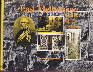
Book, Craftsmen Press, East Melbourne: 1837-1977: people, places, problems, 1977
A history of early development and more recent redevelopment in East Melbourne, from a town planning perspective.177 p., illus., maps.non-fictionA history of early development and more recent redevelopment in East Melbourne, from a town planning perspective.east melbourne, town planning, melbourne -
 Greensborough Historical Society
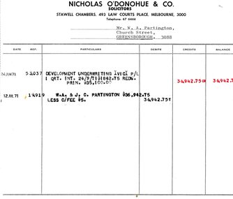
Legal record - Account, Nicholas O'Donohue & Co, Nicholas O'Donohue & Co to Partington 1971, 12/07/1971
A solicitor's account to Alan Partington following a land transaction with Development Underwriting Vic. P/L in 1971. Part of many land deals made by the Partington family in the sale of the original Greensborough farmland.Solicitor's account, black text on white paperalan partington, william alan partington, partington family, land deals greensborough, nullarbor -
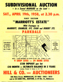 City of Moorabbin Historical Society (Operating the Box Cottage Museum)
Flyer - Marriott's Estate, Parkdale, 1958
After WWII there was a decline in the market gardens in the City of Moorabbin, as the value of the land was more profitable than the crops.Example of the progress of the Municipality of MoorabbinPhotocopy of advertising flyer for auction of real estate sales - plan of building blocks for saleMarriott's Estate, Parkdale - Auction 19 April 1958 - 39 home sites - 9 shop sitesmarriott street, chandler st, ivy st, robert st, parkdale, real estate, auction -
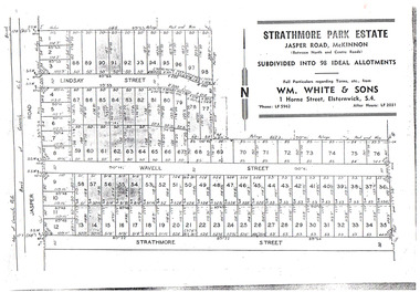 City of Moorabbin Historical Society (Operating the Box Cottage Museum)
Flyer - Strathmore Park Estate, Jasper Road McKinnon, 1942
After WWII there was a decline in the market gardens in the City of Moorabbin, as the value of the land was more profitable than the crops.Example of the progress of the Municipality of MoorabbinPhotocopy of advertising flyer for auction of real estate sales - plan of building blocks for saleStrathmore Park Estate, Jasper Road Bentleigh Subdivided into 98 Ideal Allotmentsstrathmore street, wavell street, lindsay street, jasper road, mckinnon, bentleigh, real estate, auction -
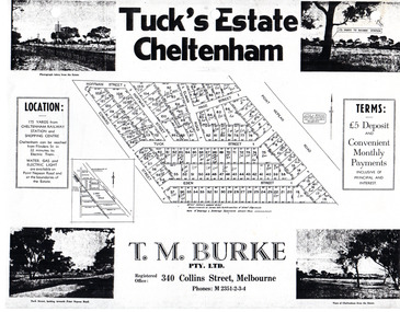 City of Moorabbin Historical Society (Operating the Box Cottage Museum)
Flyer - Tuck's Estate, Cheltenham, 1940
After WWII there was a decline in the market gardens in the City of Moorabbin, as the value of the land was more profitable than the crops.Example of the progress of the Municipality of MoorabbinPhotocopy of advertising flyer for sale of real estate sales - plan of building blocks for saleTuck's Estate Cheltenham - plan of subdivisionedward street, point nepean road, eden street, tuck street, hoffman street, elman road, page street, cheltenham, real estates, auction, tuck -
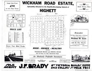 City of Moorabbin Historical Society (Operating the Box Cottage Museum)
Flyer - Wickham Road Estate, Highett, 1940
After WWII there was a decline in the market gardens in the City of Moorabbin, as the value of the land was more profitable than the crops.Example of the progress of the Municipality of MoorabbinAdvertising flyer for auction of real estate sales - plan of building blocks for saleWickham Road Estate, Highett 58 Home siteshillcrest ave, wickham road, spring road, grandview road, maroona road, highett, land sales, real estate -
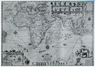 Ballarat Heritage Services
Map, Plancius's Map (Amsterdam), 1594, 1594
Copy of a Dutch map published in Amsterdam. showing a large stretch of outhern land called Terra sustralis Copy of a map from 'A Short HIstory of Australia' by Ernest Scott.map, plascius, placius's map, terra australis, dutch map -
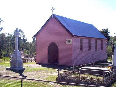 Ballarat Heritage Services
Photograph - Photograph - Colour, Clare Gervasoni, St Francis Xavier Chapel, Eganstown, 1999, 28/09/1999
The St Francis Xavier Chapel and Catholic Cemetery was established on land donated vby squatter John Egan.Three photographs of St Francis Xavier Chapel, the chapel in the Eganstown Catholic Cemetery. The grave stone at the front of the church is for John Egan. st francis xavier chapel, eganstown, 1999, eganstown catholic cemetery, eganstown, church, chapel, cemetery, john egan -
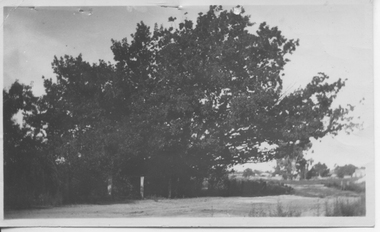 Tarnagulla History Archive
Photograph: Oak Tree, Llanelly, 1922
Not clear whether Annie Heffernan is the photographer or owner of the land where tree was situated. Donald Clark Collection. A monochrome photograph of a large oak tree in Llanelly, Victoria. Accompanied by a poem by John Hurford typed on a piece of paper. Title of poem is 'The Oak'. Dated 12/02/1922. The poem is catalogued separately.Written on reverse: 'Oak Tree Annie Heffernan Llanelly 1922'.llanelly, trees, tree -
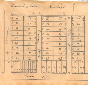
 City of Kingston
Pamphlet - Black and white, J. F. Brady, The Hill Estate, Highett, c. 1905
Sales plan for land in the suburb of Highett, bounded by Sandford Street, Turner Street and Point Nepean RoadThe developing urban area of Highett within the City of Kingston. This land sale pamphlet illustrates the subdivision of land within the municipality and the changing demographic of the district as new houses are constructed close to infrastructure.Black and white pamphlet advertising for sale the Hill Estate, Highett. Incorporates a map of the estate bordered by Sandford Street, Turner Street and Point Nepean Road.Handwritten in grey pencil on reverse: The Hillland sales, highett, estate -
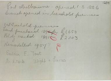 Port Melbourne Historical & Preservation Society
Document - purchase and building costs SSB, Public Records Office Victoria (PROV), 1886 - 1982
The State Savings Bank building was constructed c1891. This note outlines land purchase costa and building costsCOPYRIGHT Public records Office Victoria .03 - 1886 document built environment - commercial, business and traders, state savings bank of victoria -
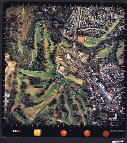
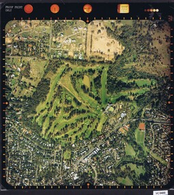 Heidelberg Golf Club
Photograph - Aerial Photograph, Heidelberg Golf Course 2000, 01/05/1980
Aerial photograph of Heidelberg Golf Club course in 1980, showing the course layout and surrounding land use.Aerial photograph, colour.Printed on edge of photo: "Colour proof", "LandSur756"aerial photographs, heidelberg golf club, lower plenty -
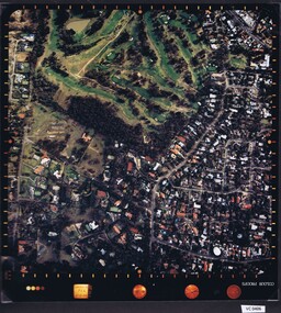 Heidelberg Golf Club
Photograph - Aerial Photograph, Heidelberg Golf Course 2000, 01/05/1980
Aerial photograph of Heidelberg Golf Club course in 1980, showing layout of course and surrounding land use.Aerial photograph, colour.Printed on edge of photo: "Colour proof", "LandSur756"aerial photographs, heidelberg golf club, lower plenty -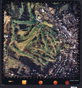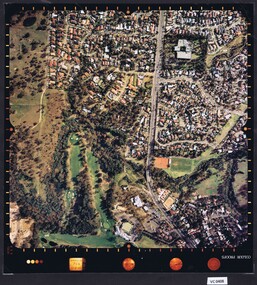
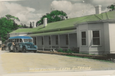 Lakes Entrance Historical Society
Postcard - Kalimna Hotel, 1955c
Kalimna Hotel built 1884 to 1885 by Thomas Laughton on land previously leased by Peter Egan FishermanTinted postcard of Kalimna Hotel showing a Pioneer Tourist Coach parked at the front with glimpse of Beer Garden on Western side of main building, Hotel Road Kalimna Victoriabusinesses, hotels -
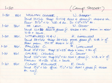 The Beechworth Burke Museum Research Collection
Card (Series) - Index Card, George Tibbits, Camp Street, Beechworth, 1976
George Tibbits, University of Melbourne. Faculty of Architecture, Building and Town & Regional PlanningIndex system that support the research for Beechworth : historical reconstruction / [by] George Tibbits ... [et al]Arranged by street names of BeechworthEach index card includes: street name and number of property, image of property, allotment and section number, property owners and dates of ownership, description of the property according to rate records, property floor plan with dimensions.beechworth, george tibbitsbeechworth, george tibbits -
 Kew Historical Society Inc
Plan, Melbourne & Metropolitan Board of Works : Borough of Kew : Detail Plan No.1581, 1904
The Melbourne and Metropolitan Board of Works (MMBW) plans were produced from the 1890s to the 1950s. They were crucial to the design and development of Melbourne's sewerage and drainage system. The plans, at a scale of 40 feet to 1 inch (1:480), provide a detailed historical record of Melbourne streetscapes and environmental features. Each plan covers one or two street blocks (roughly six streets), showing details of buildings, including garden layouts and ownership boundaries, and features such as laneways, drains, bridges, parks, municipal boundaries and other prominent landmarks as they existed at the time each plan was produced. (Source: State Library of Victoria)This plan forms part of a large group of MMBW plans and maps that was donated to the Society by the Mr Poulter, City Engineer of the City of Kew in 1989. Within this collection, thirty-five hand-coloured plans, backed with linen, are of statewide significance as they include annotations that provide details of construction materials used in buildings in the first decade of the 20th century as well as additional information about land ownership and usage. The copies in the Public Record Office Victoria and the State Library of Victoria are monochrome versions which do not denote building materials so that the maps in this collection are invaluable and unique tools for researchers and heritage consultants. A number of the plans are not held in the collection of the State Library of Victoria so they have the additional attribute of rarity.Original survey plan, issued by the MMBW to a contractor with responsibility for constructing sewers in the area identified on the plan within the Borough of Kew. The plan was at some stage hand-coloured, possibly by the contractor, but more likely by officers working in the Engineering Department of the Borough and later Town, then City of Kew. The hand-coloured sections of buildings on the plan were used to denote masonry or brick constructions (pink), weatherboard constructions (yellow), and public buildings (grey). The streets and built structures in this plan were surveyed in 1903 and released to contractors in 1904. In addition to the designation of building types by colour, the plan includes detailed descriptions of land use and ownership. While many buildings remain from this period, a number of the buildings represented have been demolished including the original Kew Town Hall, and the Congregational and Roman Catholic churches in Walpole Street. While the mansion ‘Illapa’ in Princess Street is still extant – now part of ‘Rylands’ – the neighbouring mansion ‘Elsmere’ was demolished some decades ago. Rivalling Illapa and Elsmere in size were two mansions in Walpole Street, one named on the plan as ‘Gnarlbine’. Over time, Kew Junction and the south side of High Street have been reconfigured and widened, so that the commercial buildings on the corner of Princess and High Street no longer exist. A surprising feature of this part of central Kew to the northwest of Kew Junction is the amount of vacant land. In a number of cases, this land is noted by the contractor as used for vegetable gardens.melbourne and metropolitan board of works, detail plans, maps - borough of kew, mmbw 1581, cartography -
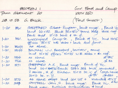 The Beechworth Burke Museum Research Collection
Card (Series) - Index Card, George Tibbits, Cnr Ford and Camp Streets (Ford St), Beechworth, 1976
George Tibbits, University of Melbourne. Faculty of Architecture, Building and Town & Regional PlanningIndex system that support the research for Beechworth : historical reconstruction / [by] George Tibbits ... [et al]Arranged by street names of BeechworthEach index card includes: street name and number of property, image of property, allotment and section number, property owners and dates of ownership, description of the property according to rate records, property floor plan with dimensions.beechworth, george tibbitsbeechworth, george tibbits -
 City of Moorabbin Historical Society (Operating the Box Cottage Museum)
Plan - Grandview Estate
The train line from the city to Frankston was electrified in 1922 which intensified the sale in the municipality of Moorabbin, particularly land which was in the vicinity of the railway stations.The train line from the city to Frankston was electrified in 1922 which intensified the sale in the municipality of Moorabbin, particularly land which was in the vicinity of the railway stations. The Grandview Estate was auctioned on Saturday 10 November 1922.Example of the progress of the Municipality of MoorabbinHand drawn map of subdivision Grandview Estate, Bentleighcentre road, evelyn street (now wilson street), lily street, bentleigh, realestate, auction -
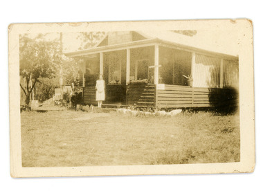 Mt Dandenong & District Historical Society Inc.
Photograph
Jim Keogh owned Lot 7 of the Village Settlement. When the new CRB road went through c1920 his block was cut through leaving a small triangle of land on the high side of the CRB road. He built a shop on this piece of land. The store burned down 31/12/1939. The woman on the step in this photo is Win Woodcock.Sepia image of a woman standing in front of a wooden store. Handwritten inscription on reverse by John Lundy-ClarkeJim Keogh's shop on the north west corner of Falls and Main Roads. Opposite diagonally from St Michael's Church of England. photo Nov 1926.jim keogh, keogh, store, shop, crb road, win woodcock -
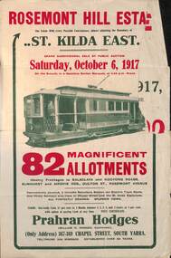 Melbourne Tram Museum
Ephemera - Real estate sale, Prahran Hodges, "Rosemont Hill Estate", Oct. 1917
Pamphlet advertising the sale of land at the "Rosemont Hill Estate", Balaclava Road, St Kilda East, 6-10-1917. On the front cover has a photo of PMTT tram No. 27. Gives terms of sale, the plan of the subdivision, and a general locality plan showing tram and rail lines. Land prices have been written in for some blocks on the pamphlet. Demonstrates the style of land sale pamphlet including the availability of tram services to prospective purchasers.Pamphlet - folded - printed in two colours of cream coloured paper with photographs and plans.has pencil notes re sale price and notes for some blocks.sale of land, trams, real estate, balaclava road, st kilda east, pmtt, tram 27, rosemont hill estate -
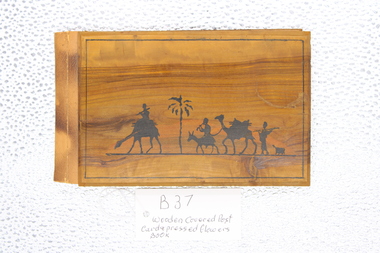 Shepparton RSL Sub Branch
Postcard and Pressed Flowers Book, Wooden Covered Postcard and Pressed Flower Book from Jerusalem 1941, approximately 1941
souvenirs from the middle Eastern Countries during WW2A wooden covered book; 10 pages with post card and on left hand side and pressed flower arrangements on opposite page. Pages separated by translucent tissue paperBlack inked drawing depicting camels , cameleers and palm tree on front cover; central back wooden cover 'Jerusalem' printed Inside cover in handwriting " To Mother From Dad 18th January 1941" Book title " Flowers and Views of the Holy Land - Fleurs et vues de la Terre Sainte" postcard pressed flower book -
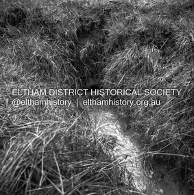 Eltham District Historical Society Inc
Negative - Photograph, J.A. McDonald, Fordhams Road, Eltham, 24 July 1962
Culvert discharging towards land owned by Holloway & Spicer about 3pm on 24 July 1962 Heavy rainRecord of various Shire of Eltham infrastructure works undertaken during the period of 1952-1962 involving bridge and road reconstruction projects, sometimes with Eltham Shire Council Project Reference numbers quoted. It was during this period that a number of significant improvements were made to roads and new bridges constructed within the shire that remain in place as of present day (2022). In many situations, the photos provide a tangible visible record of infrastructure that existed throughout the early days of the Shire. The album was put together by or under the direction of the Shire Engineer, J.A. McDonald.1962-07-24, culvert, eltham, fordhams road, infrastructure, shire of eltham -
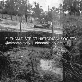 Eltham District Historical Society Inc
Negative - Photograph, J.A. McDonald, Fordhams Road, Eltham, 24 July 1962
Culvert discharging towards land owned by Holloway & Spicer about 3pm on 24 July 1962 Heavy rainRecord of various Shire of Eltham infrastructure works undertaken during the period of 1952-1962 involving bridge and road reconstruction projects, sometimes with Eltham Shire Council Project Reference numbers quoted. It was during this period that a number of significant improvements were made to roads and new bridges constructed within the shire that remain in place as of present day (2022). In many situations, the photos provide a tangible visible record of infrastructure that existed throughout the early days of the Shire. The album was put together by or under the direction of the Shire Engineer, J.A. McDonald.1962-07-24, culvert, eltham, fordhams road, infrastructure, shire of eltham