Showing 10433 items
matching sites
-
 City of Ballarat
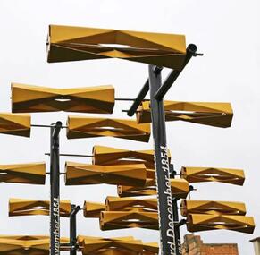
Artwork, other - Public Artwork, Aaron Robinson et al, Flow by Holly Grace and Aaron Robinson, 2014
Water is key to a thriving community and it is through the representation of water Flow enlivens the space at Bakery Hill. Historically ‘water races’ ran through the valleys of the Greater Ballarat area unearthing the minerals that forged prosperity and wealth. This water still flows today unearthing new possibilities for the community. Possibilities focusing on sustainability, ecology, health and prosperity. Flowing over the site a series of kinetic turbines flutter in the wind creating a contemporary water race. The interactive elements offer visual stimulation enticing people to connect with the artwork and in turn the surrounding spaces. Bakery Hill has great historical significance. It’s connection to the Eureka Stockade and the series of events that were to unfold during the 1850’s was to become the turning point in Australian political history. The placement of each turbine is to mirror a point of history in the timeline of events that occurred during the Eureka Stockade. The Water Race is a symbol of possibilities, the ones created by history and those of modern society. It is a visual timeline that can be read by traversing the site. The connecting turbines that flow and turn in sync are a representation of time passing and the interconnectedness of history with the community that surrounds it. The gateway to Bridge Mall is framed through the placement of each turbine allowing the sense of prosperity and wealth to flow through to the surrounding community. This gateway also references the significance of Bakery Hill reinvigorating the historical site by reconnecting it back to its town centre. The artwork is of aesthetic and historical significance to the people of BallaratTwelve steel turbines set on poles with dates attached and a large bronze 'timeline' plaqueFLOW/ Plotting the motion of Wind, Water, History and Time/ by Holly Grace and Aaron Robinson/ This site has great historical significance. It’s connection to the Eureka Stockade and the series of events that unfolded in the 1850’s was to become the turning point in Australian history. The placement of each turbine within this artwork mirrors a point of history in the events that led up to the Eureka Stockade. It is a visual timeline that can be read by traversing the site. The connecting turbines that flow and turn in sync are a representation of time passing. They are a symbol of the community’s connection to their history. 1851 June James Esmond makes the first discovery of gold in Victoria at Clunes./ 1st July The Port Phillip District separates from New South Wales and becomes the Colony of Victoria. It is still subject to British rule./ August Gold is discovered at Buninyong and at Golden Point, Ballarat. Lt-Governor La Trobe introduces the Gold Licence system in an attempt to reduce the colony’s debt./ 20th September First gold licences issued in Ballarat. / 1852 August/ Eureka Lead discovered on the Ballarat goldfields. December Charles La Trobe resigns as Lt-Governor but he is not relieved until 1854/ July – December/ Unrest builds on the various goldfields with protest meetings held in Bendigo and Castlemaine. Bendigo’s Red Ribbon Movement is active on the goldfields and the Bendigo Petition is presented to Lt-Governor./ December/ Charles Hotham is appointed Lt-Governor/ 1854 March/ A bill to extend the Elective Franchise is passed by the Legislative Council and sent to London for the assent of the British Parliament. 22nd June/ Lt-Governor Sir Charles Hotham arrives in Victoria. The colony faces mounting debt and Hotham orders weekly licence hunts in an attempt to increase income./ August/ Hotham is acclaimed during his visit to the Ballarat goldfield./ 13th September? Hotham orders twice-weekly licence hunts to further increase revenue./ September – October/ Miners are experiencing problems – no shafts bottomed on the Eureka Lead for five weeks./ 7th October/ James Scobie is murdered outside the Eureka Hotel. Many diggers believe that publican James Bentley is responsible./ 9th October/ At Scobie’s inquest, Bentley is acquitted, despite strong evidence of his guilt./ 10th October/ Father Smythe’s servant is beaten up by authorities and falsely arrested for not holding a licence./ 15th October/ Mass meeting of miners on Bakery Hill. Catholic miners meet after Mass. // 17th October/ A meeting of up to 10,000 Diggers is held near the Eureka Hotel to protest against Bentley’s acquittal. The meeting results in the burning of the hotel. Three diggers, Westerby, Fletcher and McIntyre, are arrested. Hotham dispatches 400 soldiers to Ballarat. 22nd October/ Another large meeting is held to address grievances. The Catholics send their leaders, Hayes, Kennedy and Manning to meet Rede. The Government Camp is under siege 11th November/ A public meeting on Bakery Hill results in the formal establishment of the Ballarat Reform League and adoption of the League’s proposals./ 21st November/ The enquiry into the Bentley affair is published. It recommends the dismissal of the judge and the establishment of a Royal Commission. 23rd November/ Westerby, Fletcher and McIntyre are convicted of burning the hotel. The Ballarat Reform League demands their release. 27th November/ A deputation from The Ballarat Reform League, including Humffray, Black and Kennedy, meet with Hotham to demand the release of the three prisoners. Hotham does not believe the diggers have the right to “demand anything”, Rede requests reinforcements in Ballarat. 28th November/ Miners attack the troop reinforcements and wagons passing near the Eureka diggings. A drummer boy is seriously wounded. 29th November/ A “Monster Meeting” attended by more than 10,000 diggers is held on Bakery Hill. The Southern Cross flag is flown for the first time. Peter Lalor addresses the miners and a number of diggers burn their licences. 30th November/ A licence hunt occurs in the morning at the order of Commissioner Rede. Another meeting of radical miners is held on Bakery Hill. Peter Lalor becomes leader of the diggers and calls for volunteers. Many diggers wear an oath to defend their rights and liberties under the Southern Cross flag. A number of diggers move to the Eureka Lead and start to erect a stockade. 3rd December In the early hours of Sunday morning 296 soldiers and police led by Captain Thomas proceed from the Government Camp to the Eureka Lead and attack the Stockade. 22 diggers and 7 military are officially listed as being killed. Many others are wounded. Approximately 120 diggers are arrested and marched to the Government Camp. 4th December/ Funeral of some of the fallen diggers and soldiers. Martial Law is proclaimed in Ballarat. Henry Seekamp, editor of the Ballarat Times is charged with seditious libel. 6th December/ Major General Sir Robert Nickle, commander-in-chief of the military forces in the Australian colonies, arrives in Ballarat. 9th December/ General Nickle repeals martial law. 14th December/ The Gold Fields Commission sits for the first time. 18th December/ The first Ballarat sitting of the Gold Fields Commission is held at Bath’s Hotel. 1855 23rd January/ Henry Seekamp is found guilt of sedition and sentenced to three months in prison. 22nd February/ The Eureka trials starts in Melbourne. February to March/ 13 prisoners are tried and acquitted amid great public rejoicing. 27th March Report of the Royal Commission recommends miners’ rights and significant reforms. 10th November/ Peter Lalor and John Basson Humffray are nominated for seats in the legislative Council. 31st December Sir Charles Hotham dies before his resignation takes effect. flow, aaron robinson, holly grace, public art, eureka stockade, bakery hill -
 Ringwood and District Historical Society
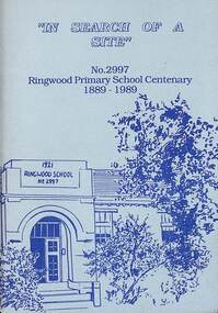
Booklet - Book, In Search of a Site, 1989
History of the Ringwood Primary School No 2997 from 1889 to 1989 Contents include List of Head Teachers/Principals, Finding a Site, Time Line, Reminiscences of Miss Daisy Paddock, Anecdotes From Former Pupils. Acknowledgement - In researching the history of Ringwood Primary School, we would like to acknowledge the valuable information obtained from the History of Ringwood Primary School compiled by Mr. J.A. Baines. -
 Kew Historical Society Inc
Print - Walmer Street Foot Bridge, 1901
Photographic print of the Walmer Street Bridge. The view of the Bridge is from the Abbotsford side of the Yarra. A section of pipe on the near side of the bridge is a remnant of the irrigation pipes that carried water from above Dight's falls to the Melbourne Botanic Gardens. The former bridge, constructed in 1896 was swept away in the 1901 Flood. It has two major brick piers while the remainder of the trestle supports are metal. The original photograph from which this copy was made was taken after 1901 as it shows the second bridge under construction. Houses in Young Street, Kew, can be seen on the far side of the river.Reverse: " Walmer St footbridge 1901 being repaired after flood / Constructed 1892 substantially renewed in 1901 and in 1928 / Rebuilt in 1977 by Kew Council aided by State funding. Won for designer Martin Aylard a New Zealand award presented by the timber Research & Development Assoc / Site of Simpsons Road passenger foot ferry". bridges - yarra river -- kew (vic.), walmer street bridge -- kew (vic.) -
 Greensborough Historical Society
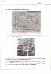
Article and Photograph, All Saints Anglican Church Greensborough, 2018_
Information and photographs of All Saints' Anglican Church Greensborough from the 1940s and 1950s. Includes a hand drawn map of the original site on the corner of Main Street and Grimshaw Street.This photograph and text was copied from a Facebook site. Members are people who lived in the Greensborough area and share their reminiscences of the area with others. The site is administered by a GHS member but is not officially affiliated with the Society. Any information is the opinion of the contributor. Article and photograph sourced from social media.all saints anglican church greensborough -
 Federation University Historical Collection
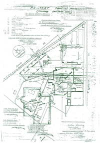
Plan, Plan Former Ballarat Gaol and Ballarat School of Mines Buildings, 1926/1927
After the closure or the Ballarat Gaol the space was taken over by the Ballarat SChool of Mines and the gaol building was demolished. The E.J. Tippett Library is now on the site of the former Gaol building.Copy of 1928 plans for the Ballarat Gaol, with two Ballarat School of Mines buildings marked on it - The Student Amenities building and the Learning Resource Centre (E.J. Tippett Library). It shows a 'future Teaching Building' which was never built.ballarat school of mines, ballarat gaol, plan, student amenities building, learning resource centre, e.j. tippett library, governor's residence, warden's residence -
 Eltham District Historical Society Inc
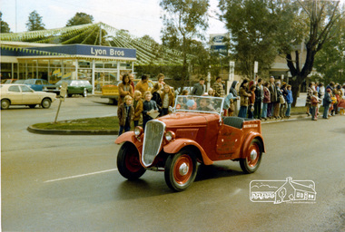
Photograph, Ruth H. Pendavingh, Eltham Festival, Main Road, Eltham, 1975c
Photo taken at corner of Arthur Street looking across to Lyon Bros. Ford dealership on site of original Lyons Garage. The new post office is visible to the right of the dealership.Two colour photographs looking diagonally across Main Road, Eltham towards Lyon Bros Ford dealership. One photo shows a 1935 Datsun driving past the gatherered crowd in the medium strip, the other shows a 1974 XB Ford Falcon utility with bunting and a sign on the side advertising ''Sausage Sizzle'eltham, festivals, main road, lyon bros ford, post office -
 Kew Historical Society Inc
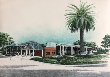
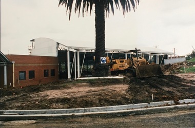
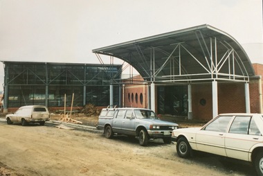
Photograph, City of Kew, Kew Recreation Centre, c.1986
The first Kew Municipal baths were built on a site in High Street (Kew) in 1925. Since then, various rebuilding have occurred, most involving extending or relocating the pool. Photograph of an architectural drawing of the proposed Kew Recreation Centrekew municipal baths, kew recreation centre -
 Kew Historical Society Inc
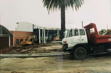
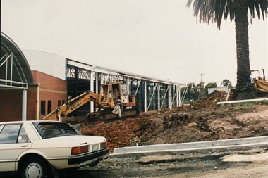
Photograph, City of Kew, Kew Recreation Centre, c.1987
The first Kew Municipal baths were built on a site in High Street (Kew) in 1925. Since then, various rebuilding have occurred, most involving extending or relocating the pool. Photograph of construction activities at the Kew Recreation Centre.kew recreation centre, public works -- kew (vic) -
 Kew Historical Society Inc
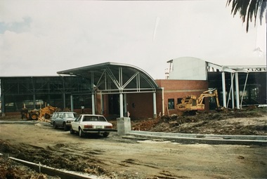
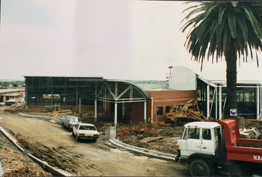
Photograph, City of Kew, Kew Recreation Centre, c.1987
The first Kew Municipal baths were built on a site in High Street (Kew) in 1925. Since then, various rebuilding have occurred, most involving extending or relocating the pool. Photograph of construction activities at the Kew Recreation Centre.kew recreation centre, public works -- kew (vic.) -
 Kew Historical Society Inc
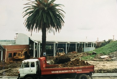
Photograph, City of Kew, Kew Recreation Centre, c.1987
The first Kew Municipal Baths were built on a site in High Street (Kew) in 1925. Since then, various rebuilding have occurred, most involving extending or relocating the pool. Photograph of construction activities at the Kew Recreation Centre.kew recreation centre, public works -- kew (vic.) -
 Kew Historical Society Inc
Photograph, City of Kew, Kew Recreation Centre, c.1987
The first Kew Municipal Baths were built on a site in High Street (Kew) in 1925. Since then, various rebuilding have occurred, most involving extending or relocating the pool. Photograph of construction activities at the Kew Recreation Centre.kew recreation centre, public works -- kew (vic.) -
 Tatura Irrigation & Wartime Camps Museum
Photograph - copy, D. Clark, Brown's Bakery and residence, 1989 copy
Photograph showing residence of Browns Bakery and part of shop and old palm tree on left. Also part of Collivers shop on right. Zappias Pharmacy now on bakery site.Black and white copy photograph of residence and part of Brown's bakery, Hogan Street, Tatura. Late 1940's.on back: Browns Bakery and residencebrowns bakery -
 Tatura Irrigation & Wartime Camps Museum
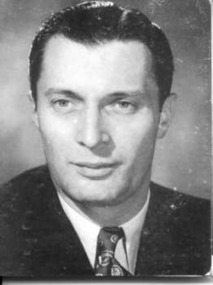
Photograph, Nicola Cua, c. 1950
Photo of Nic Cua who was, after the formation of the Tatura Historical Society, the first former internee to return from the U.K. to visit the Camp 2 site. Now deceased.Head and shoulders sepia photo of man with collar and tie, neatly combed hair.On back of photo- Nicola Cua; 6 Shirley Heights; Shirley Road; Wallington. SMG 9QD Surrey. 01 647 2719.camp 2, italian internee, "dunera", "arandora star", photography, photograph, slides, film -
 Uniting Church Archives - Synod of Victoria
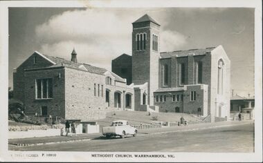
Photograph, 1939?
The Warrnambool Methodist Church (now the Uniting Church) was open on the 1st of April 1939. It was built on the site of two previous churches constructed in 1850 and 1857. (See H94-2)Postcard in "The Rose Series", glossy, of the Methodist Church in Warrnambool, its sanctuary, Sunday School, and KindergartenMethodist Church Warrnambool, Vic. P 10910warrnambool; methodist church; uniting church; koroit street; liebig street -
 Uniting Church Archives - Synod of Victoria
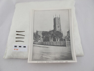
Nails
St Andrews Presbyterian Church which was established in Rathdowne Street Carlton in 1854. St Andrews Church was demolished on the site in 1938 and the stone was used to build a church in Gardiner. Square nails from St Andrew's Presbyterian Church, Carlton. -
 Hume City Civic Collection
Photograph, 1972
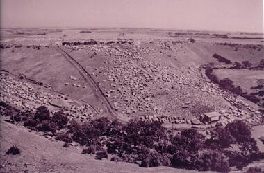
The photograph was taken during the 1972 Sunbury Pop Festival which was staged on a property owned by George Duncan. The site is on the banks of the Jacksons Creek between Sunbury and Diggers Rest.An aerial photograph of a crowd of people on a hillside and along a creek valley with a stage set up. On the LHS there is a large marquee surrounded by cars and pitched tents. There are trees around the creek and vast open paddocks in the distance.sunbury pop festival, jacksons creek, duncan, george, george evans collection -
 Hume City Civic Collection
Photograph, early 1980s
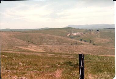
The Sunbury Tip was transferred from the end of Reservoir Road as housing development spread in that area to a site on the NW side of Mt. Holden near Riddell Road in the early 1980s.A landscape coloured photograph with rounded corners. It is a panoramic view of open country NW of Sunbury near Riddell Road. There is a fence post with barbed wire hanging from it in the immediate foreground and Macedon Ranges and part of the Western Highlands can be seen across the skyline.macedon ranges, mt. macedon, camel's hump, sunbury municipal tip, george evans collection -
 Uniting Church Archives - Synod of Victoria
Photograph, undated
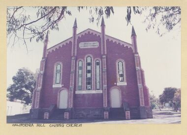
The red brick Wesleyan Methodist church was the third church building on the site. It was built to seat 500 people, at a cost of 2401 pounds. The church was opened on 11 July 1875. Colour photograph of the exterior of the California Hill Uniting Church (Bendigo).california hill, wesleyan methodist, bendigo -
 Uniting Church Archives - Synod of Victoria
Photograph, undated
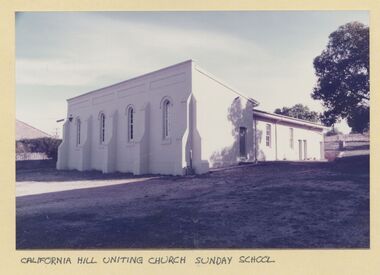
The red brick Wesleyan Methodist church was the third church building on the site. It was built to seat 500 people, at a cost of 2401 pounds. The church was opened on 11 July 1875. Colour photograph of the exterior of the California Hill Uniting Church Sunday School (Bendigo).california hill, wesleyan methodist, bendigo -
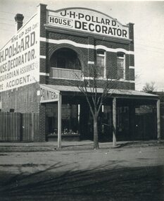 Surrey Hills Historical Society Collection
Photograph, Shop of J H Pollard, House Decorator, at 139 Union Road, Surrey Hills, 1930
This site was later occupied by Mitton's pharmacy. James Henry Pollard appears on the 1903 electoral roll as a painter in Canterbury Road (in one of the buildings that made up Hansen's Terrace.)The Union Road shops are covered by a City of Boroondara Heritage Overlay. This particular shop has changed very little with some alteration to the upper storey when it was repurposed for residential dwelling.Black and white photo of James Henry Pollard's shop at 139 Union Road, Surrey Hills in 1930. It is a 2 storey brick building with 2 glass display windows either side of the door and a corrugated iron roofed verandah supported on 3 posts. Above is a dwelling with 2 sash windows and an interior balcony within an arch. A wooden paling fence adjoins on the left. The side of the building and the front pediment carry advertising for the business. From this it appears that James Henry Pollard was an insurance agent for Guardian Assurance Company as well as being a house painter and decorator. There is a deciduous tree in the front of the shop.businesses, shops, mitton's pharmacy, guardian assurance company, union road shops, james henry pollard, painter, decorator -
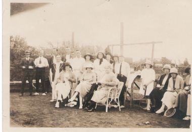 Sunbury Family History and Heritage Society Inc.
Photograph, c1930s
The group of tennis players were photographed on a court that was sited in Evans Street, adjacent to the post office. It was used by many residents before the tennis centre was built in Ligar Street.The tennis courts sited in Evans Street were one of the early sports venues set up and use by the residents in Sunbury.A sepia photograph with a cream frame of a group of people gathered on a tennis court. Some are seated and others a standing and a few in the group are holding tennis rackets. A high wire fence is behind the group.tennis, tennis courts, evans street -
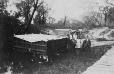 Halls Gap & Grampians Historical Society
Photograph - B/W, C 1932
A family on holiday in the Grampians. The deep wagon is an early form of caravan, which folded down and was ready to erect when a site was found. The man is Jack Diamond from Donald.The photo shows a family (a man, a woman, a girl and a boy) standing beside an old car pulling a deep, wooden wagon covered by a tarpaulin. A mans hat sits on the tarpaulin near the man's elbow.The wagon appears to be standing in water and there is a wooden slat surfaced bridge ortrestle to the right. A track with two signposts is in front of the car and there is thin bush in the background.recreation, camping, transport, cars -
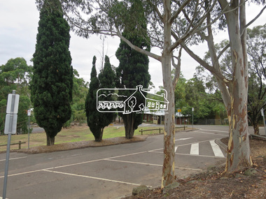 Eltham District Historical Society Inc
Photograph, Jim Connor, Main Road, Eltham, 14 Jan 2017
Eltham Gateway, Shilinglaw trees at 895 Main Road, Eltham, site of the former Eltham Shire Council offices. In distance is The Eltham Senior Citizens Hall on Library PlaceTomorrow's history documented todayeltham, jim connor collection, main road, eltham gateway, library place, senior citizen's hall, shillinglaw trees -
 Eltham District Historical Society Inc
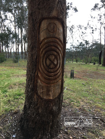
Photograph, Peter Pidgeon, Killeavey, Laughing Waters Road, Eltham 5 Nov 2016, 5 Nov 2016
This tree carving represents the ceremonial circle at the meeting place formed on the site of the original homestead. The replicating circles reflecting the life stories. Heriitage Excursion - Kileavey Walk and TalkBorn Digitalactivities, eltham district historical society, heritage excursion, kileavey, parks victoria, laughing waters road, eltham, wurundjeri -
Port Melbourne Historical & Preservation Society
Functional object - Brick, Auld Reekie Hotel, Rouse Street, Port Melbourne, c. 1850
Obtained from site of demolished hotel, believed to be named 'George Washington' on northwest corner of Nott and Rouse Streets. Believed to have been originally used as ship's ballast.Brick, made at 'Grange near Kirkcaldy', salvaged from demolished hotel, Rouse Street (originally the Auld Reekie Hotel)hotels, auld reekie hotel, george washington hotel -
 Churchill Island Heritage Farm
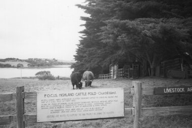
Photograph - Photograph of Highland Cattle
Churchill Island Heritage Farm has a large photograph collection dating from the nineteenth century. This series provides an insight into the early days of Churchill Island as a Conservation site.Black and White Photograph of two Highland Cattle grazing in a paddock enclosed by a wooden fence, behind a sign reading 'F.O.C.I.S. Highland Cattle Fold - Churchill Island.' Catalogue number written on reverse in pencilchurchill island