Showing 10390 items
matching plan
-
 Bendigo Historical Society Inc.
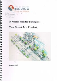
Book - CITY OF GREATER BENDIGO: MASTER PLAN FOR BENDIGO'S VIEW STREET ARTS PRECINCT AUGUST 2007, August 2007
City of Greater Bendigo Document ''A Master Plan for Bendigo's View Street Arts Precinct. August 2007. Don Goldsworthy - Architect and Urban Designer, Positive Solutions Arts Facilities and Business Planning, Cardno Grogan Richards Engineering and Traffic Management. Booklet 47 Pages.City of Greater Bendigobendigo, planning, view street arts precinct, http://www.bendigotourism.com/things-to-do/bendigo-arts-culture/view-street-arts-precinct -
 Bendigo Historical Society Inc.
Document - MARKS COLLECTION: PLAN OF FORTUNA VILLA ENTRANCE HALL
Copy of plan: Written on top: Proposed Entrance Hall, Fortuna Villa, for G. Lansell, Esq. Plan shows section of building, central staircase leading to front doors, double doors with side panels. Turret, with skylights on top. Signed on top: 'W. Beebe, Architect'.buildings, house, fortuna villa -
 Falls Creek Historical Society
Plan - Leases of part of Falls Creek Tourist Area, 1984
Bob (Herman) Hymans (a former member of the Royal Netherlands Navy was born in Bloemendaal, Holland on 30th September 1922. During World War II he fought against the Japanese in the Dutch East Indies (now Indonesia) and was imprisoned in Changi and on the Burma Railway. After gaining qualifications as a Ski Instructor, Bob arrived in Falls Creek in May 1950. Working as an Instructor and Supervisor at Bogong Lodge, Bob decided his future was in accommodation. He was successful in negotiating an indenture for land from the State Electricity Commission (SEC). It took Bob two years to build his Grande Coeur Chalet but, tragically, it was burned down in August 1961. Bob also built the first Chairlift in Australia. This was a single chairlift and the structure was built from wooden electricity poles. He was constantly full of new ideas and proposals for the village. Bob Hymans died on 7th May 2007. This Collection of documents and letters tells the story of Bob’s endeavours to develop Falls Creek into the ski village it is today. This map is significant because it documents boundaries of early leases in Falls Creek Tourist Area.This map is part of Bob Hymans documents. It is a large Surveyor's Plan of a section of the Falls Creek Tourist Area. It is endorsed by J Parker, Chief Surveyor of the State Electricity Commission of Victoria on 27-3-84. It shows streets, lot numbers and measurements. It was a compilation created from existing lease maps. Heading - PART OF FALLS CREEK TOURIST AREA PART OF CROWN ALLOTMENT 1 PARISH OF CARRUNO PART OF CROWN ALLOTMENT 1 PARISH OF DARBALANG COUNTY OF BOGONGmap of falls creek, falls creek leases, falls creek 1980s -
 Bendigo Historical Society Inc.
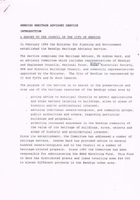
Document - BENDIGO HERITAGE ADVISORY SERVICE: REPORT TO COUNCIL, JAN 1987
Bendigo Heritage Advisory Service - Report to Council, Jan 1987, This appears to be a draft report as there are handwritten changes on a number of pages. Report is set out in the form of an Introduction and a Summary. Advisory Service comprised Heritage Advisor, Andrew Ward; Bendigo and Eaglehawk Councils; National Trust; Bendigo Historical Society; MPE and Historic Buildings Council; community representatives??; City of Bendigo - Cr Rod Fyffe, Mr Norm Cameron. Recommendations - Changes to Planning Scheme; Policy encouraging reuse of Buildings; Adoption of Action Plans; Council to encourage Heritage based Tourism; Appropriate development applications encouraged. Attached are seven short papers on specific aspects of heritage planning - 1. a Statement of Bendigo's Significance; 2. The economic importance of heritage planning; 3. Planning Scheme heritage provisions; 4. Procedures for permits; 5. Action plans for Bendigo precincts; 6. Reuse of buildings; 7. Government incentives for heritage conservation., (this last one not attached as ''Already Circulated''.Bendigo Heritage Advisory Servicebendigo, council, heritage advisory committee, bendigo and eaglehawk councils. national trust, bendigo historical society, historic building council. reuse of buildings. -
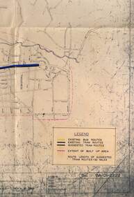 Ballarat Tramway Museum
Map - Map/s, State Electricity Commission of Victoria (SECV), Ballarat bus routes, 1971
Set of five maps prepared by the SEC/Transport Regulation Board? reviewing the option for Ballarat bus routes after the closure of the Ballarat tramway system. Based on SEC drawing No. BA-D1-2222, drawn at 1" = 20 chains. Shows streets in Ballarat and Sebastopol areas. 1775.1 - tram lines shown in heavy blue lines, with grey and yellow (actual operating bus routes at the time?) routes marked out. A red dashed line defines the general built up area. 1775.2 - "PLAN A" - shows various routes in different colours for Davis, Sproule, Hick ex Whkes, Lyons, Braybrooks and Witkins services and existing tram lines. 1775.3 - "Plan B" 1775.4 - "Plan C" 1775.5 - "Plan D" 1175.6 - Plan as above, but showing existing bus routes, tram routes and suggested tram routes. Has a small sheet of paper that was clipped to the drawing. Not dated. Not known exactly the basis that these plans were drawn up on. Drawings to be scanned.trams, tramways, closure, bus routes, tram replacement, sec, transport regulation board, ballarat, tram routes -
 Ringwood and District Historical Society
Newspaper, Scrapbook Clipping, Library Collection, Ringwood, Victoria
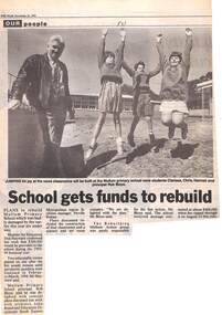
Newspaper Clipping from "The Mail", 16-11-1993. P 31 Our peoplePlans to rebuild Mullum Primary School which was badly damaged by fire earlier this year are under way. The Minster for Education, Don Hayward confirmed lasty week that $200,000 would be provided to the school during the 1993-1994 financial year. The Principal, Rob Bloye, said he was delighted with the concept plans discussed last week with architect John Brand. -
 Kew Historical Society Inc
Plan - Subdivision Plan, H C Crouch, Old Golf Links Estate, 1930s
The land in North Kew between the Outer Circle Railway and the River Yarra was released in sections. This release included 80 lots. Most of this area was released during the Depression years in the early 1930s.Subdivision plans are historically important documents used as evidence of the growth of suburbs in Australia. They frequently provide information about when the land was sold on which a built structure was subsequently constructed as well as evidence relating to surveyors and real estate and financial agents. The numerous subdivision plans in the Kew Historical Society's collection represent working documents, ranging from the initial sketches made in planning a subdivision to printed plans on which auctioneers or agents listed the prices for which individual lots were sold. In a number of cases, the reverse of a subdivision plan in the collection includes a photograph of a house that was also for sale by the agent. These photographs provide significant heritage information relating house design and decoration, fencing and household gardens.One part of a massive subdivision of the Old Golf Links Estate in North Kew of 80 allotments bordering Sutherland Avenue, Ramsay Avenue, Belford Road, Beresford Street and Coleman Avenue. Inset on the plan at the top left, the route of the Outer Circle Railway is clearly marked. The Kew Golf Links is identified in its current location. The land on which Greenacres Golf Club was to be constructed is at this time marked as ‘Recreation Ground’. The ‘new bridge’ over the Yarra at Burke Road is also marked on the inset map. The Plan identifies the surveyor (sic) H.C. Crouch BCE MVIS, 443 Little Collins St., Melbourne. The date of the subdivision auction sale in identified as Saturday September 25th at three o'clock.Annotations: "E" top left. "Golf Links" top right. Lots 73-76 ticked and listed as "6" poundssubdivisions -- kew (vic.), old golf links estate -
Glen Eira Historical Society
Plan - Nithsdale
This file contains one item about this property: Three postcard sized photographs of a flyer for the subdivision sale of the area incorporating this property for Saturday 22/11/1924. The flyer shows photographs (black and white) and plan of the area around 'Nithsdale'.nithsdale', caulfield north, hudson street, bambra road, kambrook road, centre way, oak court, caulfield railway station, balaclava road, glenhuntly road, caulfield racecourse -
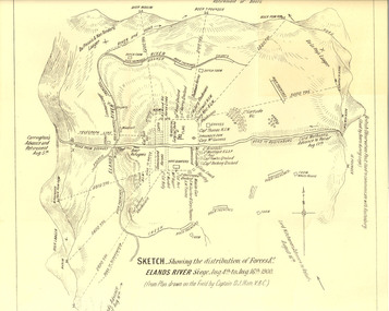 Federation University Historical Collection
Plan, Sketch of Elands River Siege, 1900
Plan based on the field notes of Captain David John Ham, V.B.C. For article written by Ham on the event, see http://trove.nla.gov.au/ndp/del/article/9542500 For obituary of Ham, see http://trove.nla.gov.au/ndp/del/article/11023251Sketched paper map of forces' distribution at the Elands River siege. Map details surrounding hills, roads, rivers, and names all soldiers involved in siege. boer war, map, sketch, victorian's bushmen contingent, hocking, fowles, methuens, david john ham -
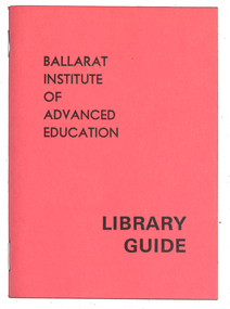 Federation University Historical Collection
Booklet, Waller & Chester, Ballarat Institute of Advanced Education and Ballarat College of Advanced Education Library Guides, c1975-1978
Ballarat Institute of Advanced Education and Ballarat College of Advanced Education is a predecessor institution of Federation University Australia. The small library guides published to assist users of the Mt Helen Library. .1) Yellow covered booklet of 31 pages, including Ballarat College of Advanced Education library plans and, photographs, c1976. .2) Salmon covered booklet of 31 pages, including Ballarat Institute of Advanced Education library plans and, photographs, c1975 .3) Green covered booklet of 31 pages, including Ballarat College of Advanced Education library plans and, photographs, c1978.mt helen library, e.j. barker library, ballarat college of advanced education, library, librarians, law collection, audio-visual collection, catalogues, card catalogue, loans, reciprocal borrowing, counter reserve, ballarat institute of advanced education, dewey classifications, fines, periodical collection, examination papers, conversation rooms -
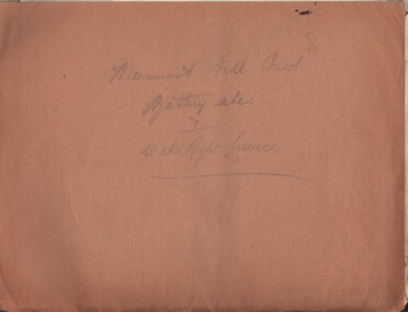 Bendigo Historical Society Inc.
Document - MCCOLL, RANKIN AND STANISTREET COLLECTION: MONUMENT HILL CONSOL. BATTERY SITES & WATER RIGHT LICENCE
Documents: Manilla folder - licences to treat tailings with various plans & notes attached. Various notes - tailings licences Central Nell Gwynne & Monument Hill. Plans for areas applied for on leases 10852, 10166,10423,10238. Plans - area applied for tailings licence applications for leases/water right licences. Prospectus Nell Gwynne(BML) Mines N/L. Various notes relating to above Monument Hill Consol. Battery sites & water right licence.MCCOLL RANKIN & STANISTREETorganization, business, gold mining, mccoll rankin & stanistreet -
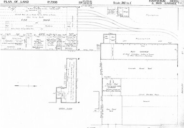 Melbourne Tram Museum
Drawing, Melbourne & Metropolitan Tramways Board (MMTB), "Footscray Depot and bus garage", c1937
Set of three photocopied plans or drawings on A3 sheet of "Footscray Depot and bus garage" c 1937 .1 - P7993 - Plan of land showing car shed, bus garage and offices dated 1-4-1937 - shows substation location. .2 - P? - Plan of land showing buildings and surrounding properties - dated 1-4-1937 .3 - P79821 - ditto but a wider area - dated 1-4-1937 - shows substation location.trams, tramways, drawings, depots, property, footscray depot, substation -
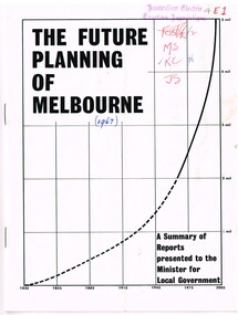 Melbourne Tram Museum
Document - Report, Commerce News, "The Future Planning of Melbourne - A summary of Reports - Minister for Local Government", 1967
Printed report or paper, 16 pages on gloss paper, centre stapled titled "The Future Planning of Melbourne - A summary of Reports presented to the Minister for Local Government" looking at the growth of Melbourne, water supply, metropolitan boundaries, 1966-67. Includes submissions from Town and Country Planning Association, MMBW, Regional planning, decentralisation, finance, commuter services. Process created by Rupert Hamer, the Local Government Minister at the time. Published as a supplement to "January Commerce News.""4E1" in ink on front cover, AETA stamp, the date "(1967)" and peoples initials on the front cover.trams, tramways, melbourne, victoria, development -
Port Melbourne Historical & Preservation Society
Plan - Montague Housing Development
COPYRIGHT PUBLIC RECORDS OFFICE Set of plans and documents relating to the State Savings bank, Montague Housing Development, in Gladstone St, Montague. This was an initiative of South Melbourne City Council to replace slum housing in Montague, 1935-40 .02 - 41 A4 pages including index, copies (some laminated)built environment - domestic, state savings bank of victoria -
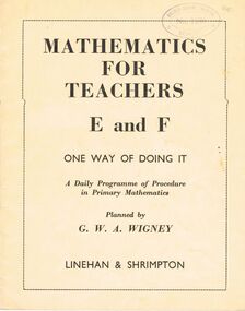 Bendigo Historical Society Inc.
Book - GOLDEN SQUARE LAUREL STREET P.S. COLLECTION: MATHEMATICS FOR TEACHERS
Two copies of Mathematics for Teachers, Covering Sections E and F, One Way of Doing It, planned by G.W.A.Wigney. Books have cream coloured covers with black printing. Book contains plans for lessons. 8800.17d bears what may be a signature that looks very like the surname Gotch.By G.W.A. Wigney, Registered at G.P.O Melbourne for transmission through the post as a book. Wholly set up and printed in Australia by Renown Press Pty Ltd., 16-20 Woorayl Street, Carnegie.education, primary, golden square laurel st p.s., golden square laurel street p.s. collection - mathematics for teachers e and f, g w a wigney, linehan & shrimpton, renown press pty ltd, education department -
Bendigo Historical Society Inc.
Map - CAMPBELL COLLECTION: BENDIGO AND DISTRICT MAPS, 18-6 29
Map. Longlea, Parishes of Axedale and Eppalock, scale 20 chains to 1 inch, total area 2372 acres. Prepared from Assessment Plan and Parish Plan by H.A. Darby18-6-29., Wondong, Heathcote and Sandhurst line (Railway). (number 386 in map cupboard 1)H.A.Darbymap, bendigo, agricultural lands -
Port Melbourne Historical & Preservation Society
Document - Submissions, Barak Road and Beacon Road developments, 1972
22 stapled pages regarding Barak & Beacon Roads development. Submissions to Minister of Lands from Cr TURNER and Cr JULIER 1972. MMBW planning map. Fishermens Bend Productivity Group working committee notes. Drawings and plans for housing, notes on developments 1955 -1972built environment - public housing, built environment - domestic, local government - city of port melbourne, leslie stanley turner, raymond frank julier, perce mcguire white, perce white, w a borthwick -
Bendigo Historical Society Inc.
Document - LANDS OFFICE: DISTRICT SURVEYORS SANDHURST INDEX OF PLANS, no date probably 19C
Document: dark green hard cover journal with buff spine and corners. Index in front A - Z. 400 pages, pages not indexed but numbered. Index lists places of various districts e.g. Bridgewater on page 7. Plan details give allotments, parish, sections, plan number.Lands Officecottage, miners, lands office, index of plans, plans -
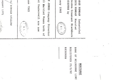 Whitehorse Historical Society Inc.
Document, Blackburn, 1/08/1995 12:00:00 AM
py of Certificate of Title Vol 8380 Fol 661, Lot 1 on Plan of Subdivision No 56619 fronting on Gordon Crescent near Central Road,Photocopy of Certificate of Title Vol 8380 Fol 661, Lot 1 on Plan of Subdivision No 56619 fronting on Gordon Crescent near Central Road, Blackburn to Finlay Urquhart, 7 November 1962; with plans from Vol 6839 Fol 696 from which title is derived.py of Certificate of Title Vol 8380 Fol 661, Lot 1 on Plan of Subdivision No 56619 fronting on Gordon Crescent near Central Road,land subdivision, gordon crescent, blackburn, central road, urquhart, finlay, newman, jeffrey william forbes, valerie, jones, ian edward swanson, joan mary, strickland, kenneth william, wilma dawn -
 Warrnambool and District Historical Society Inc.
Letter book 15, 1920s
This letter book contains letters, sketch maps and plans and dates from 1929 to 1934. It came from the office of John William Crawley Junior, an engineer, surveyor, and architect in private practice in Warrnambool and also the engineer for the Shire of Warrnambool from 1895 to 1935. His father, brother and son were also engineers, working in that capacity or as Shire Secretary for the Shire of Warrnambool, with the Crawley family recording a total of 132 years of service to the Shire. The Shire of Warrnambool existed from 1863 to 1994. The letter book was passed on to John Crawley’s son, Rolf who was the engineer for the Shire of Warrnambool from 1935 to 1968. It then came into the possession of Michael Hand who took over the private surveying business of Rolf Crawley in Warrnambool. The Warrnambool and District Historical Society acquired the letter book, along with several other Crawley ledgers, from the estate of Michael Hand. This letter book is of considerable importance as it contains letters and maps from the late 1920s and 1930s and was compiled by John Crawley Junior, an engineer in the Shire of Warrnambool for 40 years. It will be a useful research tool. This is a hard-cover letter book of 1005 pages. It contains an alphabetical index at the front, handwritten letters, sketch maps and plans and some loose sheets. It has brown leather binding on the corners of the cover and on the spine but the spine covering is completely detached. The gold lettering on the spine is now almost completely obliterated. The cover is scuffed and torn. ‘Private Book’ ‘1929 to 1934’ john william crawley junior, warrnambool, rolf crawley, warrnambool, shire of warrnambool -
 Kew Historical Society Inc
Plan - Subdivision Plan, Raheen Estate Subdivision, 1960
Subdivision plans are historically important documents used as evidence of the growth of suburbs in Australia. They frequently provide information about when the land was sold on which a built structure was subsequently constructed as well as evidence relating to surveyors and real estate and financial agents. The numerous subdivision plans in the Kew Historical Society's collection represent working documents, ranging from the initial sketches made in planning a subdivision to printed plans on which auctioneers or agents listed the prices for which individual lots were sold. In a number of cases, the reverse of a subdivision plan in the collection includes a photograph of a house that was also for sale by the agent. These photographs provide significant heritage information relating house design and decoration, fencing and household gardens.The Raheen Estate Subdivision of 1960 involved the creation of 36 residential allotments and the sale of 34 of these. The land on which the subdivision was created had until 1960 formed part of the grounds of the mansion Raheen in Studley Park Road. In 1917, the Catholic Church had purchased Raheen and its lands. It was to become the home of Archbishop of Melbourne, Daniel Mannix, for 46 years. The sale of the subdivision took place three years before the Archbishop’s death. Subsequent archbishops were to reside at Raheen until its sale to the Pratt family in 1981. When the sale of the Estate was reported in the newspapers in 1960, it was described as the last big subdivision near Melbourne. At the auction, 33 of the 36 allotments were sold. The auction realised £315,750. Purchasers were advised that the vendor intended to keep lots 22 and 23. The alllotments in the subdivision required the construction of new roads. These included Eamon Court and Raheen Drive. The justification provided by the Church for the sale was that the estate was being sold to finance school building projects.subdivision plans - kew, studley park, raheen estate, eamon court, studley park road, coombes avenue, raheen drive -
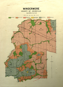 Federation University Historical Collection
Map, Windermere, County of Grenville
Coloured geological map of Windermere, County of Grenville. Scale is 40 chains to 1 inchwindermere, grenville, krause, plan, map -
Federation University Historical Collection
Map, City of Ballarat and Borough of Sebastopol Road Map
Road map of the City of Ballarat and the Borough of Sebastopol. WGS 85 Centroid 37 degrees 33 feet 56 inches south 143 degrees 51 feet 09 inches eat E-W- extent: 9 km N-S- extent: 11.5 kmballarat, sebastopol, map, plan, ballarat shire -
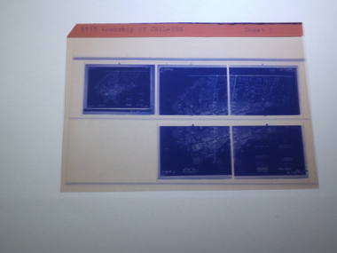 Rutherglen Historical Society
Microfiche of 5 Aperture Card sized microfilm, Victorian Land Tiltes Office, Township of Chiltern
Township layout of Chilterncard with a single microfilm insertplan, town, boundries, lots, roads -
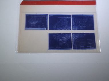 Rutherglen Historical Society
Microfiche of 5 Aperture Card sized microfilm, Victorian Land Tiltes Office, Township of Chiltern
Township layout of Chilterncard with a single microfilm insertplan, town, boundries, lots, roads -
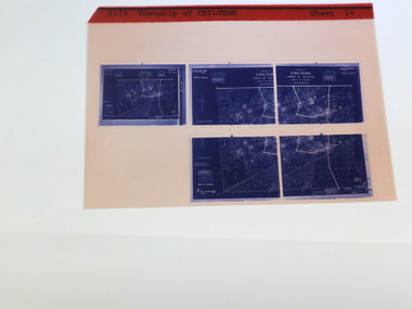 Rutherglen Historical Society
Microfiche of 5 Aperture Card sized microfilm, Victorian Land Tiltes Office, Township of Chiltern
Township layout of Chilterncard with a single microfilm insertplan, town, boundries, lots, roads -
 Rutherglen Historical Society
Microfiche of 5 Aperture Card sized microfilm, Victorian Land Tiltes Office, Township of Barnawartha
Township layout of Barnawarthacard with a single microfilm insertplan, town, boundries, lots, roads -
 Rutherglen Historical Society
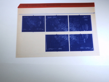
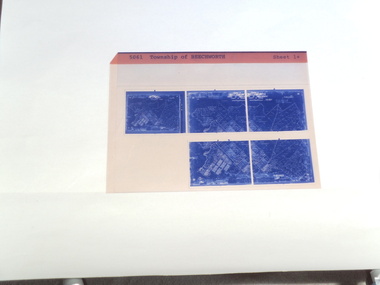
microfich sheet, Victorian Land Tiltes Office, Township of Beechworth
Town layout of Beechworth5 Aperture Sized microfilms on a single microfiche in a paper sleeve plan, town, boundries, lots, roads -
 Rutherglen Historical Society
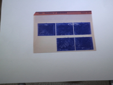
microfiche sheet, Victorian Land Tiltes Office, Township of Beechworth
Town layout of Beechworth5 Aperture Sized microfilms on a single microfiche in a paper sleeve plan, town, boundries, lots, roads -
 Rutherglen Historical Society
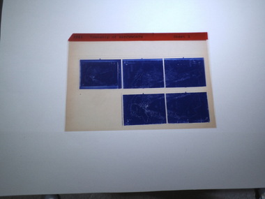
microfiche sheet, Victorian Land Tiltes Office, Township of Beechworth
Town layout of Beechworth5 Aperture Sized microfilms on a single microfiche in a paper sleeve plan, town, boundries, lots, roads