Showing 22294 items
matching parks
-
 Stawell Historical Society Inc
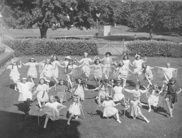
Photograph, Mrs Lindsay's Dancing Class in Central Park including the Langsford sisters
Mrs Lindsay's Dancing Class Central Park (includes the Langsford sisters)stawell -
 Stawell Historical Society Inc
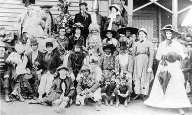
Photograph, Group in Fancy Dress taken near the Grand Stand at Central Park
Group in Fancy Dress taken near the Grand Stand Central Parkstawell -
 Stawell Historical Society Inc
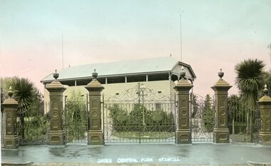
Photograph, Memorial Gates at Central Park Stawell with Gardens and Light behind Gates
Memorial Gates Central Park Stawell Garden and Light behind Gates.stawell -
 Stawell Historical Society Inc
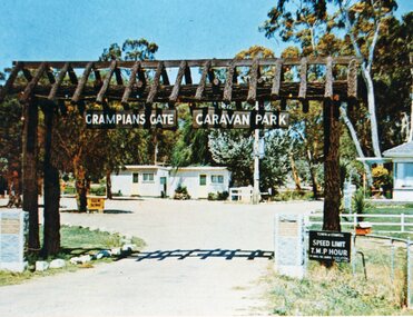
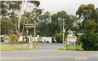
Photograph, Grampians Gate Caravan Park -- New entrance gates 1970/1971 -- 2 Photos -- Coloured
Grampians Gate Caravan Park. New entrance gates 1970/1971stawell -
 Stawell Historical Society Inc
Photograph, Grampians Gate Caravan Park -- Entrance c1966/1970 - 1970/75
Grampians Gate Caravan Park. Entrance c1966/1970 - 1970/75stawell -
 Stawell Historical Society Inc
Postcard, Cato Lake earlier called Victoria Park & a No Flies in Stawell Postcard -- 2 Photos -- Postcards -- Coloured
Cato Lake earlier called Victoria Park showing Two Rotundasstawell -
 Stawell Historical Society Inc
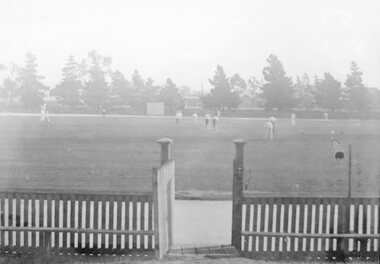
Photograph, Stawell Central Park Sports Oval with Cricketers & Gate in foreground
Central Park Sports Oval with Cricketers picket fence and Gate in foreground.stawell sport -
 Stawell Historical Society Inc
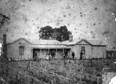
Photograph, “Cheshire Park” Homestead at Greens Creek -- Home of Mr Charles Frederick Proctor
“Cheshire Park” Homestead - Greens Creek. Home of Charles Frederick Proctor.stawell -
 Friends of Ballarat Botanical Gardens History Group
Work on paper - Director of Parks and Gardens, City of Ballarat, Interview with Bob WHITEHEAD by John Garner, 07 February 2007, 7th February 2007
Bob Whitehead, Director of Parks & Gardens for the City of Ballarat. 1978-1989The interview is valuable in terms of the development of new techniques in the Gardens and the establishment of the Friends of the Ballarat Botanical Gardens.All visible. Clear grey and white photograph of Bob Whitehead, front page. 2nd front page coloured photograph of Bob Whitehead.None.john garner collection, garner, whitehead, interview, ballarat botanical gardens, ballarat, gardens, doctor, horticulture, kevin heinze, melbourne city council, modern techniques, fernery, sequoias, conservatories, establishment of the friends of the ballarat botanical gardens -
 Wonga Park Community Cottage History Group
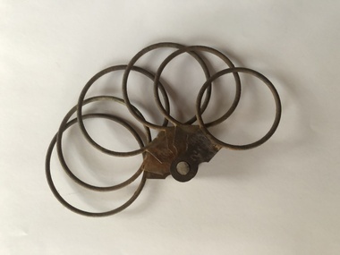
Fruit Grading Rings, Six rings to size fruit for packing, unknown
Used by R & J.M. Hooper of Homestead Road, Wonga Park on their Orchard Used in early orcharding to size fruit before packing. There are several different types of rings, but they all do the same thing, the numbers are inches of diameter, if the fruit sits on that ring and doesn’t drop through that is it’s size. Fruit of all the same diameter would be packed into a box in a pattern that didn’t move around. With apples and pears that was about 70 pieces of 3 inch fruit per bushel down to about 170 fruit of 2 inch fruit per box. The Trayrude 2 -
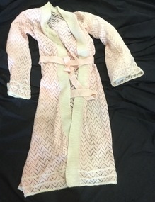 Mont De Lancey
Dressing gown, Myrtle Smith, 1934
Knitted by Myrtle Smith for her trousseau (1934). Formerly of Wonga Park.Pink hand knitted dressing gown. Has whitebands embroidered with floral motifs. Thin knitted pink belt.dressing-gowns, nightware -
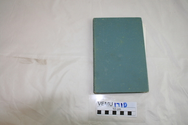 Emerald Museum & Nobelius Heritage Park
Book, On the Trail by Keith Winser, 1956
Caravanning Guide to Australia 1956. Emerald Lake Park is on page 79.Green hard cover, with 240 pages.caravaning, keith winser, 1956, motor manual -
 Lakes Entrance Historical Society
Photograph, Carpenter BBQ - John Daniel and Dorothy Callow, 1/06/1989 12:00:00 AM
at the Barbeque held at Carpenters Camp Park during the Entrance Centenary celebrations. Colour photograph of John Daniel and Dorothy Callow Lakes Entrance Victoria.1989 Also a colour photograph of Una Carpenter nee Chalmers and Gaye Pitt at the barbeque VTMH04375.7celebrations, genealogy -
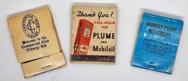 Wodonga & District Historical Society Inc
Functional object - Matchbook collection
This item is from a collection donated by Les Cole of Wodonga, who among several occupations in his life time, drove buses around the Wodonga and district for the Mylon bus company. In March 1952, Transport Parks Pty Ltd. purchased 20 acres of land from the Kelly Estate on the outskirts of Wodonga. The land sold at the record urban price for Wodonga of £300 an acre. They had plans to establish a transport park advertised as the first of its kind in Australia at a cost of £50,000. The park was to have accommodation for up to 1000 transports, caravans and cars, as well as all amenities ranging from showers to a cafeteria. It was to be known as "Twenty Acre Service Station” When the park first came into operation it was to have accommodation for up to 200 transports. Wodonga had been chosen for the site of the company's first park because it was a ''half-way house" between Sydney and Melbourne, and because transports had to stop there to obtain permits to proceed on crossing the border. The service station section of the Transport Park began operation in June 1954, with other facilities following. The business operated profitably until at least 1971 as the Transport Park, but perhaps never reached its aims of providing for 1,000 transports at any given time. The Vacuum Oil Company was the first oil company established in Australia. In 1916, Vacuum introduced its "Plume" brand to the Australian market. Vacuum replaced the famous Plume brand name with Mobilgas in 1954.A collection of 3 different match books representing a variety of businesses.match book collection, matches -
![Advertising Leaflet, Grace Park Electric Station Estate, Watsonia [1], 21/06/1924](/media/collectors/4f729f5697f83e03086015b8/items/5dcfb6fc21ea671434eb6c09/item-media/5dcfb72a21ea671434eb91fa/item-fit-380x285.jpg) Greensborough Historical Society
Greensborough Historical SocietyAdvertising Leaflet, Grace Park Electric Station Estate, Watsonia [1], 21/06/1924
Digital copy of auction leaflet for sale of land known as Grace Park Electric Station Estate, Saturday 21/06/1924. Auctioneer Knight & Harwood in conjunction with C. Jessop. This leaflet shows a home on the estate and a photograph of the proposed site of the 'Grace Park Railway Station'.Digital copy of auction leaflet 1 page. Black and red text on white paper.watsonia, grace park -
 Greensborough Historical Society
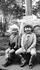
Photograph - Digital image, Lobb children at Greensborough War Memorial, 1950c
The Lobb children sitting on the base of the Fallen Soldier's Memorial Greensborough. The Memorial was moved from its original site in Main Street to Lower Park near Mrs Lobb's Kiosk (now Diamond Valley Learning Centre) before a final move to War Memorial Park.This photograph shows the Memorial at its Lower Park site.Digital copy of black and white photograph.Circa 1950fallen soldiers memorial greensborough, lobbs kiosk, lobbs tea rooms, lower park greensborough -
 Greensborough Historical Society
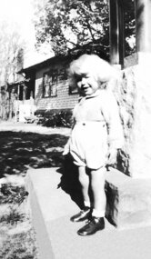
Photograph - Digital image, Lin Lobb sitting on the War Memorial, 1945c
Lin Lobb standing on the base of the Fallen Soldier's Memorial Greensborough. The Memorial was moved from its original site in Main Street to Lower Park near Mrs Lobb's Kiosk (now Diamond Valley Learning Centre) before a final move to War Memorial Park.This photograph shows the Memorial at its Lower Park site.Digital copy of black and white photograph.fallen soldiers memorial greensborough, lobbs kiosk, lobbs tea rooms, lower park greensborough -
Tatura Irrigation & Wartime Camps Museum
Photograph - copy, Mill House, 1986
Photograph of home of Mill House and upstairs extension and bullnose verandah added. Former home of George and Norma Parks and family. Nephew of Dr J. Park. House was connected with former flour mill, now demolished. Now home of Dr and Mrs C. Kerr and family.Black and white photograph of Mill House, Albert Street, Tatura. Exterioron back: Mill House with upstairs extension, home of Dr and Mrs Charles Kerr, Albert Street, Tatura 1986dr and mrs c. kerr, dr j. park, mill house tatura -
 Falls Creek Historical Society
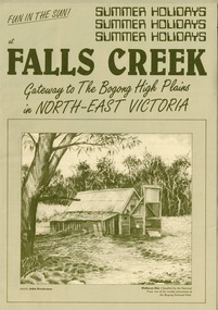
Booklet - Falls Creek: Gateway to the Bogong High Plains in North-East Victoria
A part of a yearly marketing and information material promoting Falls Creek region for the summer holidays. It focuses on Falls Creek's location in the High Plains and its connection to the Bogong National Park. Large amounts of information about activities, facilities and regulations for the use of Park facilities are included,This item is important because it documents seasonal activities at Falls Creek Alpine ResortGreen A4 size brochure for summer holiday program at Falls Creek 'Gateway to the Bogong High Plains'. Dark green printed text and images on lighter green card paper, with image of Wallaces Hut framed at bottom of page and titles above. Opens to A3 size with internal and back pages of images and information for Summer Holidays at Falls Creek. falls creek, bogong high plains, bogong national park, northeast victoria -
 Eltham District Historical Society Inc
Photograph - Digital Photograph, Alan King, Kinglake National Park, 27 March 2008
Fern gullies around Jehosaphat Gully Covered under National Estate. Published: Nillumbik Now and Then / Marguerite Marshall 2008; photographs Alan King with Marguerite Marshall.; p125 The magnificent Kinglake National Park, fringing Nillumbik’s north, is the largest national park close to Melbourne. Thanks to the vision and hard work of a band of local people, the park was created from what was rapidly becoming degraded land. Seeing a threat to Kinglake’s indigenous flora and fauna, several prominent local people campaigned for a national park, which was established in 1928.1 Since then, the park has grown through donations and acquisitions of land, from around 13,800 acres of land (5585ha) to 22,360 hectares. The Sugarloaf and Everard Blocks – of almost 8000 hectares – stand in Nillumbik and the park extends into Mitchell and Murrundindi Shires and the City of Whittlesea. Mt Everard commemorates William Hugh Everard, State member for Evelyn when the park was established. Before 1928, European settlers had degraded the Kinglake area, which was named after the celebrated English author and lawyer, Alexander William Kinglake. Remains of gold shafts and diggings in the park are reminders of Kinglake’s first settlers, who hoped to strike it rich at the gold diggings. But like other gold fields in this shire, they proved not very lucrative and soon timber cutting replaced mining in importance. However, before long, the accessible timber supply ran out, so in the 1920s agriculture took over – particularly potatoes and berry fruits – which involved large-scale clearing.2 The park’s instigator was retired Melbourne University Professor of Music, William Laver.3 As chair of the Kinglake Progress Association he began negotiations to have crown lands on the southern scarp of the Great Dividing Range reserved as a national park. Even before the park was proclaimed, from 1927, KPA members cut tracks to the major scenic points. Professor Laver was one of several people who gave land for the park, donating around 50 acres (20ha), including the Jehosaphat Gully.4 Laver chaired the park’s first Committee of Management, which raised money to employ a ranger and provide facilities, including tracks and roads for fire protection vehicles, toilets and shelters. The committee charged fees for firewood collection, some grazing of livestock, and visitor entrance, and obtained small State Government and Eltham Shire grants. In 1957 the State Government provided revenue for national parks. Then, in 1975, the State Government took over the management and the Committee of Management became an advisory committee, which disbanded in 1978. Originally, the park covered crown land in the Shires of Eltham and Whittlesea; then Wombelano Falls in Yea and other areas were added. In 1970 the park extended into the Shires of Eltham, Healesville, Whittlesea and Yea.5 Bush fires have been an ongoing problem. In 1939 hundreds of eucalypts and acacias had to be sown around the Jehosaphat Gully to rejuvenate the forest. To manage bushfires, the Committee of Management, then the State Government, worked closely with the Forestry Commission, shire councils and local fire brigades. Early national parks focussed on recreation. But by the 1980s, conservation, education and scientific research became more important, playing a vital role in preserving representative samples of the natural environment. Each year many thousands of people use the park’s extensive network of walking tracks amongst the protected plant and animal life as well as camping, cycling and horse riding. The park, along the slopes of the Great Dividing Range, has lookouts revealing magnificent views of the Melbourne skyline, Port Phillip Bay, the Yarra Valley and the You Yangs. Vegetation in the Masons Falls area includes messmate forest, Austral grass-trees, ferns and Hazel Pomaderris. In spring, orchids, lilies, everlasting daisies, correas, grevillea and heath appear. Around Jehosaphat Gully are wet and dry forest, fern gullies and banksia. Animal life includes wallabies, kangaroos, koalas, echidnas, possums, gliders and bandicoots. Male lyrebirds can be heard mimicking in the Jehosaphat Gully, particularly in the Everard Block in winter.This collection of almost 130 photos about places and people within the Shire of Nillumbik, an urban and rural municipality in Melbourne's north, contributes to an understanding of the history of the Shire. Published in 2008 immediately prior to the Black Saturday bushfires of February 7, 2009, it documents sites that were impacted, and in some cases destroyed by the fires. It includes photographs taken especially for the publication, creating a unique time capsule representing the Shire in the early 21st century. It remains the most recent comprehenesive publication devoted to the Shire's history connecting local residents to the past. nillumbik now and then (marshall-king) collection, kinglake national park, jehosaphat gully -
 Bendigo Military Museum
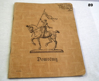
Booklet - NOTE BOOK, 6.12.1941
Book contains notes for physical training. Property belonged to Howard Maxwell DAY VX31282, 2nd AIF. Refer Reg No 92.2 for service details also 87, 88, 90, 91.2.Light brown cardboard cover; name & illustration of knight in armour on horseback on front. Inside, lined pages with margins & handwritten notes. Australian Comforts Fund loose sheet inside.Handwritten top right: VX31282 L/Cpl H.M Day 3 Corps Section 1st Aust Ord Fld Park Front centre: Domrémy Bottom left: No 4760documents - notebooks, records, training instructions -
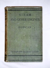 Bay Steamers Maritime Museum
Book, J. Duncan, Steam and Other Engines, 1932
Green cloth hard cover book of 537 pagesFirst page, handwritten in pencil "9/6 / William Jack T?leve / 45 Grand Avenue / Rose Park" Back cover homework instructions in same handwritting in pencilnon-fiction, engineering, steam, science, heat engines, engines, mechanics -
 Bendigo Historical Society Inc.
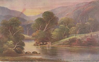
Postcard - Alice McGregor Postcard Collection, 1900 - 1920
Alice McGREGOR Born: 1908; unknown parents. Possibly adopted by the Salter family? Electoral Roll 1936: Highland Terrace Kangaroo Flat. Alice Mary Salter and William Robert Salter living together; presumed to be sister and brother. William Robert Salter was killed in a MVA in Bendigo in 1937 aged 26. In Victoria in 1938, Alice Mary Salter married James Thomas McGregor (born Victoria 1917, died Victoria 1983, buried Fawkner Cemetery) Lived: 1968; 22 Wade Street Golden Square Alice McGregor Died: 1999 aged 91 at Anne Caudle Centre, Bendigo Buried: Kangaroo Flat Cemetery See additional research. Postcard Album of Alice McGregor contained 86 post cards.Postcard Album of Alice McGregor contained 86 post cards. See 1400. Colour painting of a rural scene of 2 cows beside the Yarra at West Warburton. Addressed to Miss H G Shatford, Black Rock, Via Sandringham, Victoria Sender J G D, Emu Park, W East Dated 25 Oct 1906 postcard, collector, alice mcgregor -
 Stawell Historical Society Inc
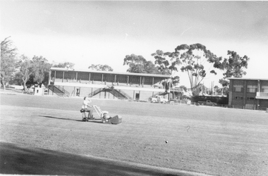
Photograph, Central Park Oval c 1980
c 1980 Parks and garden staff mowing Central Park Oval. No 2 Grandstand has its roof on. Also at the right end of the Grandstand is the Railway foot bridge which was demolished in 1991.. The Football Clubrooms built in mid 1960's is just in view on the right side. Photo of oval with garden staff mowing. No 2 Grandstand and just a section of the Football Clubhouse in view. c 1980'sstawell sports -
 Rutherglen Historical Society
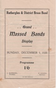
Documents, Sun Print, Grand Massed Bands Display, Sunday, December 3, 1939, 1939
The events of the afternoon included lunch for the bandsmen at the Memorial Hall, a street march to the Park, and performances at the Park, concluding with a massed march back to town. 10 bands from the surrounding districts participated. The donor was teaching at the Rutherglen Higher Elementary School at the time of this event, and boarded at the Star Hotel.Program for a massed bands display, held by the Rutherglen & District Brass Band, on December 1939. Also included is a letter from the donor.bands, rutherglen town band, wangaratta town band, mooroopna town band, corowa town band, albury town band, goulburn valley pipe band, yarrawonga brass band, finley district citizens band, beechworth town band, benalla citizens band, rutherglen higher elementary school, star hotel -
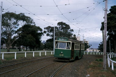 Melbourne Tram Museum
Slide - Y1 610 - Royal Park line, Warren Doubleday, August 1971
Set of two photos of Y1 class tram No. 610 on a tour on the Royal Park line August 1971. The second photo shows the tram reversing at the Royal Park crossover with the railway station in the background. Note the open ballast style track and railway style weighted point lever.Yields information about the Royal Park tram line.Set of two Kodachrome cardboard mounted slides.tramways, tramcars, y1 class, tram 610, royal park, railways -
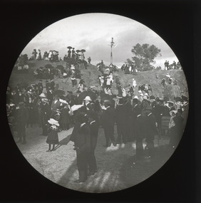 The Beechworth Burke Museum
Photograph - Lantern Slide, 1901
... parks ...This glass slide captures the unveiling of the two cannons at Queen Victoria Park which were secured by Sir Isaac Isaacs and presented to Beechworth in 1901. In the foreground, elegantly dressed ladies and dapper gentlemen can be seen gathering around the park's iconic rock, with excited children looking on from the sides. Atop of the rock stands an intricately designed gas lamp that has since been removed but evidence of its existence still remains. The unveiling of these two cannons would have been a celebratory affair for those in attendance, marking a momentous occasion for Beechworth residents that was captured in this lantern slide. Sir Isaac Isaacs was an influential figure in Beechworth, having grown up and studied there. He began his education at the Common school and eventually graduated as dux of the Beechworth Grammar School. His commitment to public service was evident early on and he was elected to the Legislative Assembly in 1892, representing Bogong, a district which included Yackandandah and Beechworth. During his time in office he pushed for better education, healthcare, employment opportunities and housing for the people of Beechworth. Lantern slides, sometimes called 'magic lantern' slides, are glass plates on which an image has been secured for the purpose of projection. Glass slides were etched or hand-painted for this purpose from the Eighteenth Century but the process became more popular and accessible to the public with the development of photographic-emulsion slides used with a 'Magic Lantern' device in the mid-Nineteenth Century. Photographic lantern slides comprise a double-negative emulsion layer (forming a positive image) between thin glass plates that are bound together. A number of processes existed to form and bind the emulsion layer to the base plate, including the albumen, wet plate collodion, gelatine dry plate and woodburytype techniques. Lantern slides and magic lantern technologies are seen as foundational precursors to the development of modern photography and film-making techniques.This glass slide captures social and historical significance as it represents a moment of celebration for Beechworth residents and symbolises an important milestone in the town's history. This lantern slide stands testament to a special moment in Beechworth’s history and its significance continues to be remembered today. It is also an example of an early photographic and film-making technology in use in regional Victoria in the time period.Thin translucent sheet of glass with a circular image printed on the front and framed in a black backing. It is held together by metals strips to secure the edges of the slide. burke museum, beechworth, lantern slide, slide, glass slide, plate, burke museum collection, photograph, monochrome, queen victoria park, rock, victoria, cannons, isaac isaacs, governor-general, politicians, judges, indigo shire, north-east victoria, 19th century, nineteenth century, parks -
 Bendigo Historical Society Inc.
Slide - Peter Ellis Collection, Kaweka Wildflower Reserve, Castlemaine, Lightning Hill Lookout Bendigo, One Tree Hill Lookout Tower Bendigo, Kamarooka Forest Area, c1970-1972
Kaweka Reserve is a a small reserve of approximately 8ha. The land was donated to the Castlemaine City to be a wildflower Reserve. A management committee was formed in 1966. The committee is still managing the park. Vicroads Edition 6: Map 59E2, 628 H4 Location. Turner St, Castlemaine. From the Castlemaine Post Office, drive north (towards Bendigo) and turn right along Turner Street to the park entrance. What to do: walk along some of the tracks through the park follow the nature trail bird watch have a picnic at the picnic tables. RUSH Dam is a basic free camping area sits alongside Rush Dam in the Greater Bendigo National Park, featuring a single picnic table and wood fire barbecue.Peter Ellis Collection: Seventeen slides of Kaweka Wildflower Reserve, Castlemaine, Lightning Hill Lookout Bendigo, One Tree Hill Lookout Tower Bendigo. Also the Rush Dam free camping area at Kamarooka. Also a slide of an unknown group having a meal or day out; perhaps also a working bee. In addition there are two slides of a house - location not specified; and a working bee clearing along a pipeline at Big Hill. Peter was a chemistry lecturer at the Bendigo Institute of technology.history, bendigo, peter ellis collection, whipstick bendigo, bendigo state forests, kaweka wildflower reserve castlemaine, one tree hill lookout bendigo, lightning hill lookout bendigo, kamarooka, rush dam kamarooka, greater bendigo national park -
 Glen Eira Historical Society
Photograph - Mayor Jack Campbell 1986-87 (1 of 2)
2 photographs of Remembrance Day ceremony at Caulfield Park memorial Nov 1986councillor, mayor, jack campbell, ron walters, hedley moore -
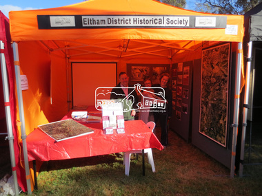 Eltham District Historical Society Inc
Photograph, Jim Connor, Eltham District Historical Society display, Eltham Festival, Alistair Knox Park, 10 Nov 2013
Eltham District Historical Society display, Eltham Festival, Alistair Knox ParkTomorrow's history documented todayeltham, jim connor collection, alison delaney, eltham district historical society, eltham festival, main road, russell yeoman, sue law