Showing 27535 items
matching yarra-river
-
 Eltham District Historical Society Inc
Photograph, Odyssey House Victoria, 28 Bonds Road, Lower Plenty, 6 March 1990
Odyssey House drug rehabilitation centre in Bonds Road, Lower Plenty is a distinctive landmark, especially when viewed from across the Yarra at Templestowe. It was built in the 1950’s as a seminary for the Blessed Sacrament Fathers. Because of the poor and circuitous road access, a suspension footbridge was built across the river. As well as providing easy access for the priests residents of Templestowe could attend services at the seminary. The bridge is now part of the Yarra Trails system.Colour photographlower plenty, bonds road, odyssey house -
 Bendigo Historical Society Inc.
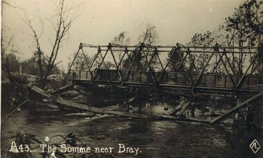
Postcard - ACC LOCK COLLECTION: THE SOMME NEAR BRAY, POSTCARD, 1914-1918
Postcard, WW1, B&W image of the River Somme near Bray showing a prefabricated steel bridge over the river with the remains of a wooden structure in the foreground. One copy number A43postcard, ww1, river somme, bray, france, bridge -
 National Vietnam Veterans Museum (NVVM)
Photograph
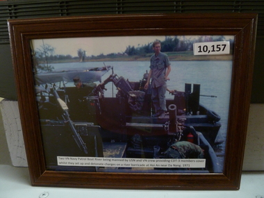
2 VN Navy river patrol boat. US & VN crew providing Audio, CDT3 members with cover while setting up detonator charges on river barricade. HOP AN 1971river patrol -
 Melbourne Tram Museum
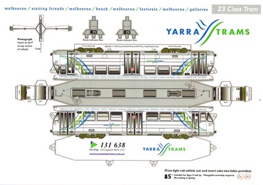
Leisure object - Cardboard Model Tram, Transit Graphics, 2005
Cardboard, punched out, folding model tram - Melbourne Z3 class tram 141 in Yarra Trams livery. Has separate parts for two route number boxes and pantograph. Has the Yarra trams info on the tram on the base of the model. Produced by Transit Graphics in 2005.trams, tramways, models, z3 class, yarra trams -
 Lakes Entrance Regional Historical Society (operating as Lakes Entrance History Centre & Museum)
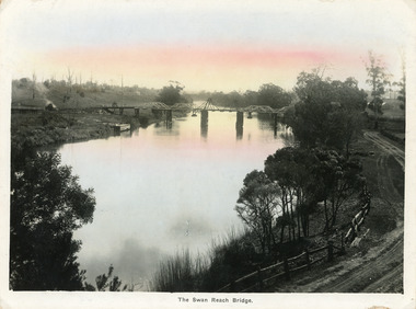
Postcard, Bulmer, H D, 1915
Colour tinted large format postcard showing lifting bridge over the Tambo River, at Swan Reach, Victoria. Bridge is closed to allow road traffic through. Rough gravel road to Metung on right. Landing on left near bridge. Vegetation on river bank right. Houses in distance on both sides of river.The Swan Reach Bridgeboats and boating, bridges -
 Eltham District Historical Society Inc
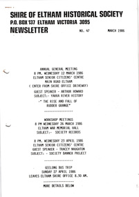
Newsletter, Newsletter, No. 47 March 1986
Contents: • Next meeting, guest speaker, Arthur Howard: Yarra River history – “The rise and fall of Rudder Grange” • Annual General Meeting • Arthur Howard • Records/Research workshops • Society Banner project • Geelong bus trip • Heritage Week • Society Calendar The Shire of Eltham Historical Society was formed in October 1967. The first newsletter of the Society was issued May 1978 and has been published continuously ever since on a bi-monthly basis. With the cessation of the Shire of Eltham in late 1994, the Society's name was revised to Eltham District Historical Society and this name first appeared with issue No. 103, July 1995. The collection of the Society's newsletters provides a valuable resource on the history of the Society's activities, office bearers and committee members, guest speakers and subjects of historical interest pertinent to the former Shire of Eltham and the Eltham District.A4 photocopied newsletter distributed to membersnewsletter, eltham district historical society, shire of eltham historical society -
 Melbourne Tram Museum
Postcard, Nucolorvue Publishing, "Melbourne - Interesting Aspects", mid 1970s
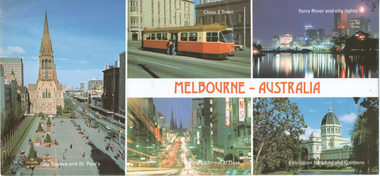
Series of five views of Melbourne - City Square (mid 1970s), with Swanston St and St Paul's Cathedral, Z class No. 2 (see item 73), Yarra River and city lights, Bourke St looking east at dusk and the Royal Exhibition buildings and gardens.Demonstrates a multi-view postcard of Melbourne.Colour postcard by Nu-Color-Vue No. NCV1316 postcards, city square, z class, tram 2, yarra river, bourke st, st paul's cathedral, swanston st, royal exhibition buildings -
 Flagstaff Hill Maritime Museum and Village
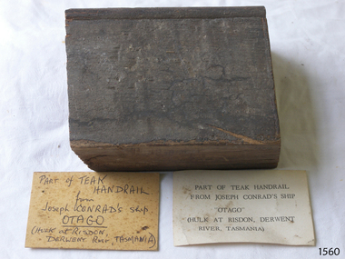
Souvenir - Wood Sample, 1869
This Teak wood sample has been taken from a handrail on the wreck of the ship Otago. The fully rigged iron-hulled sailing ship Otago was built in Glasgow for the New Zealand Government as an immigrant ship, launched in 1869. One of the captains of the Otago was Joseph Conrad. He was one of the captains of the Otago and it was the only ship that he had ever commanded. Joseph Conrad (1857-1927) Joseph Conrad was Polish-born and became a British subject in 1886. He was a renowned marine fiction writer and also, for a short time, a mariner and Captain. As a boy of 13 years old, Joseph Conrad’s desire was to be a sailor. At 19, he joined the British merchant marine, working in several roles. He eventually qualified as a captain but only served in this role once, from 1888-89, when he commanded the barque Otago sailing from Sydney to Mauritius. In 1889 he also began writing his first novel, Almayer’s Folly. He retired from life as a mariner in 1894, aged 36. Conrad’s visits to Australia from 1878 to 1982, and his affection for Australia, were later commemorated by a plaque in Circular Quay, Sydney. Conrad continued as an author. It is said that many of the characters in his books were inspired by his maritime experiences and the people he had met. By the end of his life, he had completed many stories and essays, and 19 novels, plus one incomplete novel titled ‘Suspense’ that was finished and published posthumously. Shortly before he passed away, in 1924, Conrad was offered a Knighthood by Prime Minister Ramsay MacDonald for his work but declined. The Otago: - The 1869 iron-hulled barque Otago changed hands several times in the late 19th century. In 1903 the Melbourne shipping company Huddart, Parko & Co., purchased the ship and it was converted to a coal hulk for use in Sydney. The Otago was later sent to Hobart in Tasmania where it was in use there until 1931. The ship was eventually left to lay on the banks of the Derwent River until destroyed by fire in 1957. The wood sample is significant for its association with the ship Otago, the only ship that author Josep Conrad had command of as Captain. It was known as Joseph Conrad's Otago. The sample of teak is significant as an example of materials used in the construction of the 1869 iron hulled sailing ship, bult in Glasgow, Scotland. The association with the Otago is also significant for its use in building an immigrant ship for New Zealand.Wood sample; a rectangular section of a teak wood handrail that has a bead planed along one side. Two cards with the sample have inscriptions, one handwritten and one typed. The sample is from the wreck of the barque Otago, once under the command of Captain Joseph Conrad. Handwritten card: "PART OF TEAK HANDRAIL / from / Joseph CONRAD'S ship / OTAGO / (HULK at RISDON, DERWENT River, TASMANIA) Typed card: "PART OF THE TEAK HANDRAIL / FROM JOSEPH CONRAD'S SHIP / "OTAGO" / (HILK AT RISDON, DERWENT / RIVER, TASMANIA)"flagstaff hill, flagstaff hill maritime museum and village, warrnambool, maritime museum, maritime village, great ocean road, shipwreck coast, joseph conrad, joseph conrad's ship, otago, ship's handrail, 1869 ship, migrant ship, immigrant ship, new zealand, sydney, newcastle, tasmania, iron hull, captain joseph conrad, author, mauritius -
 Warrnambool and District Historical Society Inc.
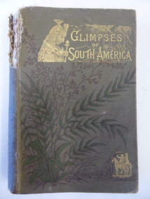
Book, Glimpses of South America, 1882
This book was given as a Sunday School prize to James Cassady. The donor was William Wines. The Wines families were pioneers in the Woodford district. James Cassady was the son of William and Elizabeth Cassady and the family lived at Boughton on the Merri River (near Cassady’s Bridge, Caramut Road today). This property was established about 1845. Charley and Joe, whose names have also been written in the book, were James’ brothers. This book is of interest because it belonged to James Cassady, the son of pioneer settlers in Cassadys’ Bridge/Woodford area. This is a hard cover book of 220 pages with 32 extra pages at the back of the book giving information on other books produced by the same publisher. The cover is grey-green with gold lettering, green and black floral decorations and gold images of two men on horseback and a South American Indian chief. The spine is torn away at the top and the cover and pages are stained and crumpled. There are many black and white illustrations throughout the text, with the frontispiece protected by a piece of tissue. The inscriptions are handwritten in black ink and pencil.‘Woodford Sunday School presented to James Cassidy (sic) by his well-wisher William Wines’ (this is re-written underneath in pencil with the correct spelling of ‘Cassady’) ‘Chaley cassady, boughton, merri river (sic) “Joe’ james cassady,, boughton, william wines, woodford sunday school, history of warrnambool -
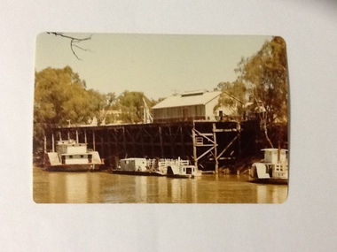 Port of Echuca
Colour Photograph, Approx.1979
P. S. PEVENSEY: Dimensions: 111ft 5 ins X 23 ft X 6ft 8 ins. Tonnage:130 tons Built: 1910 at Moama, N. S. W. References : Book: Murray river Paddle Steamers by D. Wardle Permewan , Wright & Co. : pp. 72, 129, 157 The P. S. PEVENSEY holds historical and social significance for the Port of Echuca, being the cornerstone of their paddlesteamer fleet. The PEVENSEY was renamed for the TV series All the Rivers Run, to P. S. Philadelphia , playing a staring role in the program, which has resulted in the PEVENSEY becoming a tourist attraction and has increased tourism to the Port of Echuca. The PEVENSEY was originally designed for use on the Murrumbidgee river, named after Pevensey station on that river. It was then owned by Permewan Wright & co operating out of Echuca for many years. She returned to Echuca in 1975 to begin another life as part of the Port of Echuca tourism operation.Colour photograph of the wharf and the back of the P. S. Pevensey, moored at the Port of Echuca wharf , c.1979. In front of her is a punt , a small paddle boat and to the right of the photograph part of the back of the P. S. Etona. The Cargo shed and the cranes can be seen on the wharf. Photograph taken looking south along the river.. Printed on reverse: This paper manufactured by Kodakriverboats, p.s.pevensey, echuca, port of, paddle steamers, echuca wharf -
 Kew Historical Society Inc
Photograph - The Boulevard at Kew, 1937
The Yarra Scenic Boulevard stretching from Hawthorn to the Chandler Highway was completed as a major project between 1933 and 1936 during a period of significant unemployment. Key dates in the construction this section the road include: 1933 when Kew Council supported the construction of the road from Studley Park to the Kew Asylum; and 1936 when the road from the Johnston Street Bridge to the Chandler Highway was opened. The inscription on the reverse of the photo 'Boulevard Fairfield' is misleading as there is no section of the Boulevard in Fairfield. A more likely interpretation is that it is a photograph of the Kew section of the Yarra Boulevard with the factories of Fairfield in the distance.Rare early photograph of the Yarra Boulevard, taken one year after the opening of the road. The photograph is an important historical record of the results of 'Susso' labor in the creation of major works in Melbourne by the Victorian Government. Original, black and white positive print of the Boulevard at Kew in 1937. Key aspects to note about the photograph is that the road is bituminised; that the gutters are concreted; that the kerb is constructed of concrete blocks; and that there is an unmade footpath on what appears to be the right hand side of the road. The landscape is sparsely treed, and those trees that remain are presumably remnant vegetation. At the right, the land is fenced. The land at the left falls away sharply to the river below. On the horizon, at left, there is an industrial complex including a tall chimney that is burning fuel creating smoke. "Boulevard Fairfield" great depression, susso projects, roads -- kew (vic.), yarra boulevard, yarra valley -
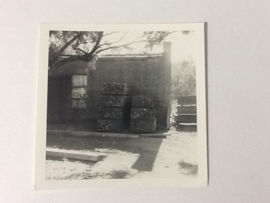 Port of Echuca
Black and white photograph, Approx. 1975
The old brick Murray River Sawmill office was demolished around 1975. This appears to be part of one of the office buildings associated with the sawmill, taken in shadow, with the building well back on the block, on the bridge side. There is a dirt driveway in front of the building and stacks of timber next to the chimney side of the building. Trees are visible behind these stacks of timber. Two stacks of timber (1x 4 blocks high, 1 X 3 blocks high) are in front of the building between the window and the chimney This relates to photographs P000106, P000105 Sawmills in the Echuca area were historically and socially significant being a large employer in the area. The Murray River sawmill was one of the biggest and longest operating sawmills in the area. Black and white photograph of an old Murray River Sawmill building with the chimney to the right and a door and window on the left. Two stacks of timber planks are against the wall between the window and the chimney. A dirt driveway is in front of the building with timber planks edging the driveway.On the reverse in pencil "Old M. R. S. Building well back on the block on the bridge side. Near old offices, also demolished about 1975??" Kodak, , in blue ink "0932"murray river sawmills, echuca, echuca, victoria, pullicino, j (unconfirmed) -
 Kew Historical Society Inc
Photograph, Floods in North Kew, 1934
Living with natural processes was frequently a challenge to early European settlers and later residents of what was in the 1850s administered by the Borondara Road Board. This was compounded by the area being bounded on three sides by rivers (Yarra River, Koonung Creek and Gardiner's Creek). In 1849, the historian James Bonwick recorded that "our district [Kew] suffered considerably. Mr Wade speaks of 80 acres, out of 100 acres of his cultivated paddock, covered by water." Newspapers continued to describe major flooding in Kew in 1863, 1869, 1878, 1880, 1889, 1891, 1916 and 1934. While the construction of the Upper Yarra dam in 1957 reduced the levels of flowing downstream, local and riverine floods continue.The Kew Historical Society's pictures and map collections testify to the impact of flooding in the district. They have historical importance in documenting the extent of flooding in the district and its affects on homes, services and recreation. Numerous photographs record flooding throughout the Twentieth Century.Floods in North Kew, 1934. Vicinity of Willsmere Park.floods (kew) -
 Kew Historical Society Inc
Photograph, Floods in North Kew, 1934
Living with natural processes was frequently a challenge to early European settlers and later residents of what was in the 1850s administered by the Borondara Road Board. This was compounded by the area being bounded on three sides by rivers (Yarra River, Koonung Creek and Gardiner's Creek). In 1849, the historian James Bonwick recorded that "our district [Kew] suffered considerably. Mr Wade speaks of 80 acres, out of 100 acres of his cultivated paddock, covered by water." Newspapers continued to describe major flooding in Kew in 1863, 1869, 1878, 1880, 1889, 1891, 1916 and 1934. While the construction of the Upper Yarra dam in 1957 reduced the levels of flowing downstream, local and riverine floods continue.The Kew Historical Society's pictures and map collections testify to the impact of flooding in the district. They have historical importance in documenting the extent of flooding in the district and its affects on homes, services and recreation. Numerous photographs record flooding throughout the Twentieth Century.Floods in North Kew, 1934. Chipperfield's Boat House under flood.floods (kew) 1934, yarra river, chipperfield's boat house -
 Kew Historical Society Inc
Photograph, Floods in North Kew, 1934
Living with natural processes was frequently a challenge to early European settlers and later residents of what was in the 1850s administered by the Borondara Road Board. This was compounded by the area being bounded on three sides by rivers (Yarra River, Koonung Creek and Gardiner's Creek). In 1849, the historian James Bonwick recorded that "our district [Kew] suffered considerably. Mr Wade speaks of 80 acres, out of 100 acres of his cultivated paddock, covered by water." Newspapers continued to describe major flooding in Kew in 1863, 1869, 1878, 1880, 1889, 1891, 1916 and 1934. While the construction of the Upper Yarra dam in 1957 reduced the levels of flowing downstream, local and riverine floods continue.The Kew Historical Society's pictures and map collections testify to the impact of flooding in the district. They have historical importance in documenting the extent of flooding in the district and its affects on homes, services and recreation. Numerous photographs record flooding throughout the Twentieth Century.Floods in North Kew, 1934. Flood near the lagoon (Billabong?)floods (kew) 1934, yarra river -
 University of Melbourne, Burnley Campus Archives
Plan - Coloured plan, Plan of Burnley Gardens, 1929?
Layout of gardens, farm buildings, orchard, etc. overlaid on part of Lands Department map. See paper catalogue for full descriptionPart of larger plan (Lands Department Parish Plan). Partly hand-drawn. Area bounded by Yarra River, Swan St, Glen Iris railway line. Shows Burnley Gardens layout, handwritten amendments and explanation of existing and proposed structures including: Pavilion, sketch of unbuilt Administrative Building, poultry yard, contours of old orchard, sketch for Plant Research Institute, ditch, silo, milking shed, laying pens. See aboveburnley gardens, pavilion, burnley school of horticulture, farm buildings, poultry -
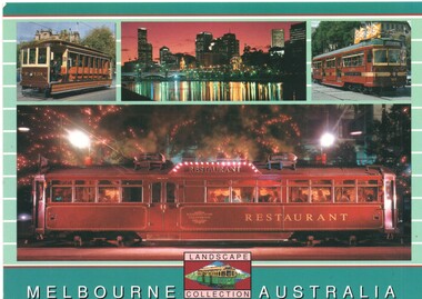 Melbourne Tram Museum
Postcard, Scancolor, Four images of Melbourne trams, mid 1970's
Colour postcard divided back - Scancolor - part of their Landscape collection featuring four photographs on one card - V214, view across the Yarra River, Circle car 909 and one of the Restaurant trams. Back has space for name and address, stamp and a message and details of the postcard. Produced by Scan colour, possibly early 2000's. Two copies held. See Reg Item 5446 for a larger photo of the Restaurant tramtrams, tramways, postcards, v class, restaurant tram, yarra river, melbourne, city circle, tram v214, tram 909 -
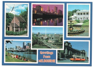 Melbourne Tram Museum
Postcard, Biscay Greetings, "Greetings from Melbourne" - 6 photos of Melbourne trams, mid 1990's
Colour postcard divided back - Biscay Greetings, series of 6 photographs of Melbourne, with the words "Greetings from Melbourne" on the lower edge. Features Cook's cottage, Banks of the Yarra River, Arts Centre, Como House and a Z class tram outside Parliament. Back has space for name and address, stamp and a message and details of the postcard. Produced by Biscay Greetings, possibly mid 1990's. Card No. BG 178.trams, tramways, postcards, yarra river, z class, melbourne -
 Vision Australia
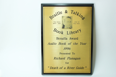
Photograph - Image, Benalla Award Audio Book of the Year 1996
This award was presented at an award night hosted by the Braille and Talking Book Library to Richard Flanagan for "Death of a River Guide". As Richard Flanagan did not receive his award on the night the Braille and Talking Book Library kept it for him, however it was not collected. To encourage the development of audio books, a series of awards were established by the National Library of Australia in 1988, and sponsored by TDK from 1991 until their demise in 2000. Open to both commercial and non-commercial publishers, it aimed to recognise the quality achievements by individuals and publishing houses and to promote the inclusion of audio books into the mainstream market.Wooden rectangle with metal plate inscribed with winners nameBraille and Talking Book Library Tilly Aston 1873 - 1947 ... that all may read Benalla Award Audio Book of the Year 1996 Presented to Richard Flanagan for "Death of a River Guide"awards, audio books -
 Port of Echuca
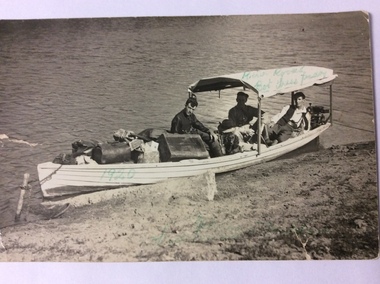
Postcard, February 1920
This is a photograph of three men in a heavily laden boat. The boat is tied up to a stick inserted into the bank. There is a black cocker spaniel dog also in the boat. The man in the middle back is believed to be John Trestrail Freeman. The card has been addressed to his wife. Dolly Freeman née Dolly Dean. The other two men , Bot and Paddy cannot be identified. The men are obviously travelling up the river. There is a motor on the back of the boat. The luggage includes a Gladstone bag, suit cases and boxes, indicating they have been travelling a long distance.This photograph is significant because it shows the type of transport available in the 1920's. Also it shows the conditions the three men travelled in. The boat was small, heavily laden with a simple motor. River traffic in 1920 would have been sparse. Also a journey from Echuca to Mildura would have taken weeks to complete.A rectangular black and white postcard showing three men and a dog in a heavily laden boat, which is tied up to the bank.On the back is printed W. GRIMWOOD/ POSTCARD/CORRESPONDENCE/ ADDRESS ONLY/KODAK AUSTRALIA . Handwritten in ink on the back are the words "To Doll from Bot, Tress, Paddy, River Rovers on Trip to Mildura Feb. 1920." Written on the front of the card in green ball point ink are the words "River Rovers Bot Tress Paddy 1920". In the bottom right hand corner in green pen is written "Echuca to Mildura. Tress Freeman."freeman, john trestrail (jr.), mildura, murray river, river rovers, freeman, dolly -
 Orbost & District Historical Society
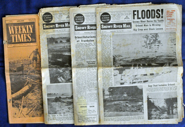
newspapers, February, March 1971
The 1971 flood was the the worst flood on record. At Jarrahmond it was at least 11 metres and up to one and a half kilometres wide on the flats causing enormous damage to the flood plain. Records say that "The brown floodwater stain in Bass Strait could be seen from passing airliners." Considerable damage was done to railway infrastructure, roads and farms. More information from the APRIL, 2008 newsletter by John Phillips. (see orbosthistory.com.au) These newspapers are contemporary records of a significant local event.Four newspapers relating to the floods in 1971. They contain news articles and photographs of the floods in Orbost in early 1971. 2556.1 is the Weekly Times dated 3.3.1971 and has an orange cover. 2556.2 is a Snowy River Mail dated 17.2.1971. 2556.3 is a Snowy River Mail dated 10.2.1971. 2556.4 is a Snowy River Mail dated 3.3.1971.floods-orbost-1971 snowy-river-mail weekly-times newspapers -
 Lakes Entrance Regional Historical Society (operating as Lakes Entrance History Centre & Museum)
Photograph, Cornell F, 1880 c
Also new sepia print 10 x 15 cm. See also Peter Synan's book 'Highways of Water'Sepia photograph showing paddle steamer Tanjil at Latrobe Wharf. Swan Hotel on left and Victoria Hotel on right. Timber stacked on wharf. People on wharf and in small boats on river on left, taken from opposite side of Latrobe River. This scene is immediately downstream of present swing bridge on Latrobe River. Sale Victoriaboats and boating, jetties, houses, disasters -
Eltham District Historical Society Inc
Document - Folder, Porter, John
John Porter owned land at the junction of the Plenty and Yarra Rivers, leased to Thomas Mundy. Contents Photocopies: Victorian Parliamentary Papers, 1864-1865, Vol, 3, No. 22, "Reports of Collectors of Agricultural Statistics", pp95-96. Handwritten notes: On George Porter, John Alfrey, Newspaper clippings, A4 photocopies, etcjohn porter, plenty river, yarra river, thomas mundy'henry stooks, john brown, diamons creek, aitken's creek, evelyn county, george porter, john alfrey -
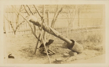 Kew Historical Society Inc
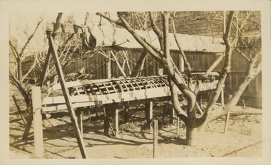
Photograph - Victorian Canoe Club, Steaming gear, 1920-30
Canoeing on the River Yarra at Melbourne was an important and widespread recreational pursuit for Melbournians, especially in the first half of the twentieth century. The Victorian Canoe Club was formed in 1912 at a meeting in Melbourne and its first committee elected in the same year. Records indicate that the Club continued into at least the 1950s .The album has historic and social significance as a record of recreational activities (as well as canoe making) in the early years of the twentieth century. It has local significance as the site of the headquarters of the Club was in Studley park. A number of photographs in the album provide vistas of Kew on the Yarra that are otherwise unavailable.One of 24 labelled photos in part album, originating from the Victorian Canoe Club, which had its headquarters in Studley Park, Kew. The album includes a photographic record of canoe construction and also locations in Studley Park and Kew where the canoes were used. The subject of this photograph is identified as 'Steaming gear' which was the equipment used in a backyard to heat and soften the wood used to make a canoe so that it would be pliable and could respond to a mould."Steaming gear"victorian canoe club, canoe making, river yarra, burke road, mornington, studley park, kew, steaming gear, canoe construction -
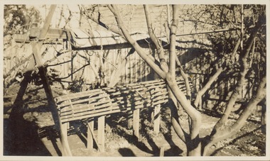 Kew Historical Society Inc
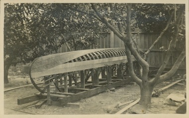
Photograph - Victorian Canoe Club, Mould for racer, 1920-30
Canoeing on the River Yarra at Melbourne was an important and widespread recreational pursuit for Melbournians, especially in the first half of the twentieth century. The Victorian Canoe Club was formed in 1912 at a meeting in Melbourne and its first committee elected in the same year. Records indicate that the Club continued into at least the 1950s .The album has historic and social significance as a record of recreational activities (as well as canoe making) in the early years of the twentieth century. It has local significance as the site of the headquarters of the Club was in Studley park. A number of photographs in the album provide vistas of Kew on the Yarra that are otherwise unavailable.One of 24 labelled photos in part album, originating from the Victorian Canoe Club, which had its headquarters in Studley Park, Kew. The album includes a photographic record of canoe construction and also locations in Studley Park and Kew where the canoes were used. The subject of this photograph is identified as 'Mould for racer' which was set up in a backyard to form the frame for manufacturing a racing canoe."Mould for racer"victorian canoe club, canoe making, canoe construction, canoe moulds -
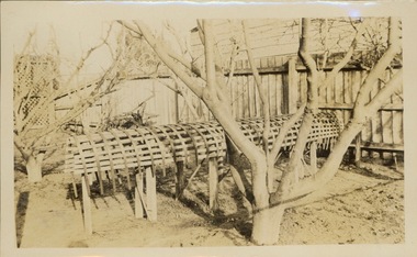 Kew Historical Society Inc
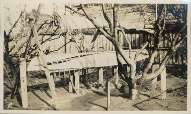
Photograph - Victorian Canoe Club, Ribs bent on mould, 1920-30
Canoeing on the River Yarra at Melbourne was an important and widespread recreational pursuit for Melbournians, especially in the first half of the twentieth century. The Victorian Canoe Club was formed in 1912 at a meeting in Melbourne and its first committee elected in the same year. Records indicate that the Club continued into at least the 1950s .The album has historic and social significance as a record of recreational activities (as well as canoe making) in the early years of the twentieth century. It has local significance as the site of the headquarters of the Club was in Studley park. A number of photographs in the album provide vistas of Kew on the Yarra that are otherwise unavailable.One of 24 labelled photos in part album, originating from the Victorian Canoe Club, which had its headquarters in Studley Park, Kew. The album includes a photographic record of canoe construction and also locations in Studley Park and Kew where the canoes were used. The subject of this photograph is identified as 'Ribs bent on mould' after being softened by steaming."Ribs bent on mould"victorian canoe club, canoe making, canoe construction -
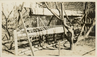 Kew Historical Society Inc
Photograph - Victorian Canoe Club, Planking, 1920-30
Canoeing on the River Yarra at Melbourne was an important and widespread recreational pursuit for Melbournians, especially in the first half of the twentieth century. The Victorian Canoe Club was formed in 1912 at a meeting in Melbourne and its first committee elected in the same year. Records indicate that the Club continued into at least the 1950s .The album has historic and social significance as a record of recreational activities (as well as canoe making) in the early years of the twentieth century. It has local significance as the site of the headquarters of the Club was in Studley park. A number of photographs in the album provide vistas of Kew on the Yarra that are otherwise unavailable.One of 24 labelled photos in part album, originating from the Victorian Canoe Club, which had its headquarters in Studley Park, Kew. The album includes a photographic record of canoe construction and also locations in Studley Park and Kew where the canoes were used. The subject of this photograph is identified as 'Planking' where the wooden planks forming the hull have been softened by steaming and bent to conform to the shape of the mould."Planking"victorian canoe club, canoe making, canoe construction -
 Kew Historical Society Inc
Photograph - Victorian Canoe Club, Planking racer, 1920-30
Canoeing on the River Yarra at Melbourne was an important and widespread recreational pursuit for Melbournians, especially in the first half of the twentieth century. The Victorian Canoe Club was formed in 1912 at a meeting in Melbourne and its first committee elected in the same year. Records indicate that the Club continued into at least the 1950s .The album has historic and social significance as a record of recreational activities (as well as canoe making) in the early years of the twentieth century. It has local significance as the site of the headquarters of the Club was in Studley park. A number of photographs in the album provide vistas of Kew on the Yarra that are otherwise unavailable.One of 24 labelled photos in part album, originating from the Victorian Canoe Club, which had its headquarters in Studley Park, Kew. The album includes a photographic record of canoe construction and also locations in Studley Park and Kew where the canoes were used. The subject of this photograph is identified as 'Planking racer' where the wooden planks forming the hull have been softened by steaming and bent to conform to the shape of the mould."Planking racer"victorian canoe club, canoe making, canoe construction