Showing 424 items
matching 'farm buildings
-
 Southern Sherbrooke Historical Society Inc.
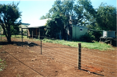
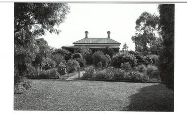
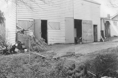
Information folder - Madigan Cottage
The buildings are probably rare remnant examples of their type in the local area and as such are significant to the settlement of Menzies Creek. The dwelling is significant as a longstanding marker of the Madigan family who were original settlers in the area. Its retention in its site close to the road boundary expresses and maintains a connection with early settlement and rural lifestyles in Menzies Creek over the last century. The old shed is of interest as a local example of bush construction, particularly in context with the cottage and farm environs. Without the life of the farm and other elements presumed now gone, its value is lessened.Folder containing information pertaining to the history of Madigan Cottage, Menzies Creek. NB: the shed was demolished in November 2001 and the cottage burned down sometime later. Contents:- Letter, Southern Sherbrooke Historical Society to Shire of Yarra Ranges, dated 9th March 2001, re. sale of property and need for it to be included in shire's Heritage Study. -Letter, shire to society, dated 20th March 2001, reply to above. -Letter, shire to society, dated 15th May 2001, follow-up to above, requesting more information. -Letter, society to shire, dated 30th May 2001, responding to above and including a copy of information previously sent to Chris Johnston, Heritage Study consultant. -Letter, society to shire, undated, noting intention to lodge an objection to proposed application for development on site. -Letter, shire to society, dated 22nd October 2001, advising of consultation meeting. -Yarra Ranges Shire Heritage Study Place Nomination form for Madigan Cottage, prepared by Marian Matta, includes nine colour photos and diagram showing where photos were taken from. -Black and white copies of photos. -A3 copy of real estate advertisement, "Mount Evergreen Estate" dated 21st April 1924. -A3 map showing proposed resubdivision boundary variation, drawn up for Mr. P. Melville, undated but 1990s. -Copy of application for a planning permit, dated 6th August 2001, including letter by Nick Jonkers describing proposed new buildings, site map showing current vegetation, letter re. proposed removal of vegetation, subdivision plan dated March 1998, and larger scale map printed from shire website on 10th August 2001. -5 A3 sheets showing site and house plans drawn up for Mr & Mrs N. Jonkers, dated July 2001.madigan cottage, menzies creek, madigan family, mount evergreen, patrick madigan -
 Southern Sherbrooke Historical Society Inc.
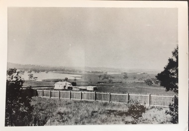
Photograph - Glen Park Farm, Selby
B&W photo showing Glen Park Farm, Selby, owned by the Johns family, as seen from the north-east corner. Photo shows the descent to the valley then up Black Hill in the background. Mostly cleared paddock apart from the cypress avenue to the farmhouse (which is glimpsed between the trees) a few single trees dotted about, and the heavily treed area on the top of Black Hill. There is a small building or shed or possibly a haystack in the centre of the photo. -
 Bendigo Historical Society Inc.
Photograph - HILDA HILL COLLECTION: BLACK AND WHITE PHOTO, 1919-1924
Hilda Hill Collection. Combination of Sepia and Black & White Photos. (Total 16.) two men with arms on each others shoulders, both with legs crossed, background shows large group of people and large trees, Hibernian Picnic November 19th 1919. Elderly lady holding two bird cages with birds therein standing in front of large flowering bush, the lady is dressed in all white and her hat lies on the ground in front of her, the hat appears to have flowers on the brim. Mrs Mc'Rosebower' October 1919. Hilda V. Standing with a background of shrubbery, wearing a dark dress, photo not very clear, 'The Ranche' March 1921. The Pinnacle One Tree Hill, people on the top lookout area and the wooden staircase for access, note the iron roof at the first level to provide shelter at ground level, April 1920. Lady on a ladies bicycle, dressed in geometric patterned dress, in front of an old shed with a corrugated iron roof. The bicycle has a front and rear mudguard, 'The Ranche' January 1920. Three ladies, the lady on the left is wearing a white dress with a black belt and holding in her right hand a small bag with a handle, the middle lady is wearing a dress of another colour with three strips of material at different levels on the front and holding her hands at her waist, also wearing lace up boots, lady to the right is wearing a white blouse and a dark skirt and her hands behind her back, background is garden, 'Durvol' December 1919. Photo of young girl dressed in black standing next to a small bush with her back to a house exterior wall, to the left is a white wall, NO Details.Three ladies standing beneath a large tree arm in arm, left girl is wearing a white top with a black belt and dark skirt, Centre girl is wearing a white top and dark skirt, girl at right wearing coloured? Dress with matching sash belt,'Durvol' December 19th 1919. Two men and three ladies in a rowing boat on lake Weeroona, both men are wearing dark suits and hats, the ladies are all in light coloured clothing and also wearing large brimmed hats. Kath wearing a black dress with a fox skin stole and holding a large bag in her right hand in garden setting, left background is a corrugated iron fence with wooden top rail, to the right is the wall of a building, September 1919 'the Ranche'. Jack wearing a black coat and jodhpurs with a white high neck jumper leaning on a wire and netting farm type fence, Mt. Buffalo July 1923. Photo of a 'Rosebower' in a garden corner, right shows part of a picket fence, wear and tear indicates that a gate may be in the fence accessible through the bower, October 1919. Two ladies holding tennis racquets, dressed in white blouses with one dark dress and the other a lighter shade sitting on stool inside a netted tennis court, both ladies are wearing large brimmed hats, background is a house with a water tank on the left end, three decorative chimneys, tiled roof, decorative panelling below the guttering, 'Kilmuir' October 1919. Lady on dark coloured horse, the lady is wearing a white blouse and jodhpurs and a large brimmed hat, background is house showing a bow window three chimneys and a small portion of the decorative fretwork below the gutter line of the verandah, 'Kilmuir' October 1919. Two young men dressing collar and tie one wearing a coat and three young ladies reclining on the ground, girl on the left is wearing a light coloured dress white blouse and cardigan, middle girl wearing a short sleeved top, right lady is wearing white blouse and dark coat, in foreground there appears to be a pudding meat and a wine bottle, left edge another male can be partially seen lying on the ground with a bottle in his left hand, at 'Monte Video' after dinner 18 July 1924. Ten people sitting and standing on a veranda, 'The Ranche', celebrating an event, small 4 wheel table with food, person front left holding a white cup and saucer, July 1924.australia, history, victoria post war touring boom, http://www.yourbrisbanepastandpresent.com/2012_02_01_archive.html -
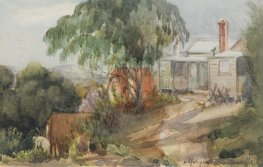 Bayside Gallery - Bayside City Council Art & Heritage Collection
Work on paper - watercolour, Margaret Baskerville, The farm shack, 1909
... farm building farm house landscape watercolour margaret ...watercolourfarm, building, farm house, landscape, watercolour, margaret baskerville, a-frame, mountain -
 Buninyong & District Historical Society
Photograph - B/W photograph, "Fassifern" Herriot St. Buninyong
Part of a series of photographs to record changes in Buninyong.B/W photograph an iron roofed brick building "Fassifern" in Herriott St. former home of David Kerr' of Kerr's Berry Farm, Somerville St.streetescape, garde, house herriott st, fassifern -
 Kew Historical Society Inc
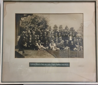
Photograph, Auburn Heights Bowling Club v Dairy Produce Salesmen, 1907
Sports Clubs in Kew in the final decades of the 19th century and in the early 20th century were often umbrella organisations with facilities for a number of sports. Typically in Kew, this included teams in lawn bowls, tennis and croquet. The Kew Bowling Club was formed in 1880 while the privately owned Auburn Heights Recreation Club was opened in 1904. By 1998, the two Clubs decided to amalgamate at the Auburn Heights site in Barkers Road, forming the Kew Heights Sports Club. The combined club was itself taken over by the Melbourne Cricket Club in 2012 becoming MCC Kew Sports Club. In 2017 MCC Kew closed and its landholding was subsequently sold to Carey Baptist Grammar School. Both the Kew and Auburn Heights Clubs assembled important collections. These historically significant and large collections were donated to the Society in 2020. The collections include manuscripts, pictures, trophies, plans, honour boards etc. References Barnard FGA 1910, 'Sports and Pastimes' in Jubilee History of Kew Victoria: Its origin & progress 1803-1910. Chapman J & C 1999, The history of the Auburn Heights Recreation Club, 1904 to 1908. Reeve S 2012, City of Boroondara: Thematic Environmental History, p.216.The combined collections of the four sporting clubs making up the collection number hundreds of items that are historically significant locally. They are also significant to the sporting history of the greater Melbourne area and to the sports of lawn bowls and tennis in Australia in the 19th and 20th centuries. The collection illuminates two of the Victorian historic themes - 'Building community life' through forming community organisations and 'Shaping cultural and creative life' by participating in sport and recreation.A framed and glazed large photograph of a tournament between members of the Auburn Heights Bowling Club and Dairy Produce Salesmen in 1907. While the match-up might seem odd, during this period, there were many diary farms and milk outlets in Kew. [The item forms part of the large historic Auburn Heights Recreation Club collection, with items relating to the sports of lawn bowls, tennis and croquet, gifted to the Kew Historical Society in 2020].clubs - lawn bowls - kew (vic), auburn heights recreation club - barkers road - kew (vic) -
 Kew Historical Society Inc
Journal, Kewriosity : July 1986
Folk dance festival in jeopardy? / p1. No [outdoor] burnings on Sundays or Mondays / p1. Rec Centre on hold - Library plans to be finalised [Kew Recreation Centre; Kew Library] / p1. Dates for July / p2. [Community] Notices / p2. Commentary - Local Government Restructure: options and issues for Kew / p3&5. Traffic Management: Works to commence in Area 5 / p3. In Brief [Grant for apprenticeship scheme; Focus on children; Kinder enrolments; Reprieve for Gatehouse; Aesthetics Advisory Panel; New City Building Surveyor - Greg Payne; New building regulations] / p4. Profile - Cr Moira Jeffreys / p4-5. Good gardening / Peter Davies p5. Lost [Woodbury Ladies' College badge] / p5. Kew Community House gearing up for busy term / Rhonda McCaw p6. Volunteers and workers wanted [Wurundjeri Industries] / p6. Keeping you informed [Citizens' Advice Bureau] / p6. Kew Band salutes Ian Mathers / p7. Calling old Deepdeners! [Deepdene Primary School] / p7. Of Ladies Loch and Brassey and their favourite drives / Nancy Noble p7. Ramblings of Kew's last cowboy: final of a series by Bill Stent [Kew dairy farms] / Bill Stent p8. Letter - More on the "pink monster" ['The Grip of Time'] / E. McCallum p8. Footy news [Kew Football Club]Kewriosity was a local newsletter combining Kew Council and community news. It was published between November 1983 and June 1994, replacing an earlier Kewriosity [broad] Sheet (1979-84). In producing Kewriosity, Council aimed to provide a range of interesting and informative articles covering its deliberations and decision making, together with items of general interest and importance to the Kew community and information not generally available through daily media outlets.non-fictionFolk dance festival in jeopardy? / p1. No [outdoor] burnings on Sundays or Mondays / p1. Rec Centre on hold - Library plans to be finalised [Kew Recreation Centre; Kew Library] / p1. Dates for July / p2. [Community] Notices / p2. Commentary - Local Government Restructure: options and issues for Kew / p3&5. Traffic Management: Works to commence in Area 5 / p3. In Brief [Grant for apprenticeship scheme; Focus on children; Kinder enrolments; Reprieve for Gatehouse; Aesthetics Advisory Panel; New City Building Surveyor - Greg Payne; New building regulations] / p4. Profile - Cr Moira Jeffreys / p4-5. Good gardening / Peter Davies p5. Lost [Woodbury Ladies' College badge] / p5. Kew Community House gearing up for busy term / Rhonda McCaw p6. Volunteers and workers wanted [Wurundjeri Industries] / p6. Keeping you informed [Citizens' Advice Bureau] / p6. Kew Band salutes Ian Mathers / p7. Calling old Deepdeners! [Deepdene Primary School] / p7. Of Ladies Loch and Brassey and their favourite drives / Nancy Noble p7. Ramblings of Kew's last cowboy: final of a series by Bill Stent [Kew dairy farms] / Bill Stent p8. Letter - More on the "pink monster" ['The Grip of Time'] / E. McCallum p8. Footy news [Kew Football Club] publications -- city of kew (vic.), kewriosity, council newsletters, community newsletters -
Kew Historical Society Inc
Journal, The Kewriosity Sheet Vol.2 No.6 : November 1980
Kew Voluntary Helpers Building Project Opportunity Shop [Kew Elderly Citizens; Hamer Court] / p1. Kew Philharmonic Society / p2. Kew City Bowmen / p2. Kew Women's Amateur Athletic Club / p2. What's doing in Kew for November / p2. Art, Craft & Home Produce Market [Kew High School] / p3. Fete [St Paul's Church] / p3. 100 years of bowling [Kew Bowling Club] / p3. A famous farm in Kew [William Wade; Belford Farm] / Elizabeth Mackie p3. Scrabble [Kew Scrabble Club] / p3. Primary School Fete [Kew Primary School] / p4. Invitation to an exhibition / p4. Council News [Report on the Development of Hay's Paddock by Landscape Architectural Consultants - Gerner, Sanderson, Faggetter Cheesman; Kew Traffic School] / p4.The Kewriosity Sheet (1979-83) was first published in the City of Kew (Victoria) in June 1979 as a two-sided 'community newssheet'. It aimed to: 'share news about Kew happenings and Kew people, and to exchange ideas about living in Kew'. Later issues gradually evolved into a 4-page, quarto sized publication. The Kewriosity Sheet was superseded by the Kew Council publication 'Kewriosity' (1983-1994).non-fictionKew Voluntary Helpers Building Project Opportunity Shop [Kew Elderly Citizens; Hamer Court] / p1. Kew Philharmonic Society / p2. Kew City Bowmen / p2. Kew Women's Amateur Athletic Club / p2. What's doing in Kew for November / p2. Art, Craft & Home Produce Market [Kew High School] / p3. Fete [St Paul's Church] / p3. 100 years of bowling [Kew Bowling Club] / p3. A famous farm in Kew [William Wade; Belford Farm] / Elizabeth Mackie p3. Scrabble [Kew Scrabble Club] / p3. Primary School Fete [Kew Primary School] / p4. Invitation to an exhibition / p4. Council News [Report on the Development of Hay's Paddock by Landscape Architectural Consultants - Gerner, Sanderson, Faggetter Cheesman; Kew Traffic School] / p4. community publications --- kew (vic.), the kewriosity sheet, newsletters - kew (vic.) -
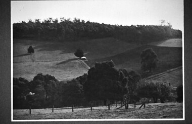
 Kew Historical Society Inc
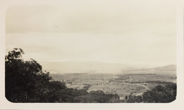
Photograph - Panoramic landscape, c.1926
Henry Beater Christian (1886-1962) , was a descendant of one of the earliest settler families in Kew. Employed at the Kew Asylum as a 'public servant', he was a skilled amateur photographer, photographing numerous scenes in Kew and on his travels around Victoria. The majority of his photographs date from 1916 to 1929. His finest photographs are housed in two photograph albums. Digital copy of a photograph from page 30 of the 47-page photograph album containing 261 gelatinous silver images, loaned by Diane Washfold with permission given to digitise and hold a copy in our collection. John Chapman has written in 'Bushwalking Clubs - A Brief History', about the establishment in Victoria of the first bushwalking club in 1888, and the popularisation of bushwalking during the interwar period. Henry Christian's 'walks' appear to have been undertaken solely or with a companion/s. This black and white panoramic photo is untitled, but follows a page of photos taken on a walking trip between Cockatoo and Gembrook in Victoria. The view selected by the photographer is of a farmed and settled valley with roads and scattered buildings.[Untitled]henry beater christian (1886-1962), landscape photography, christian-washfold collection, photograph albums, bushwalking -
 Kew Historical Society Inc
Plan - Subdivision Plan, Violet Farm Estate, 1927
Pru Sanderson, in her groundbreaking ‘City of Kew Urban Conservation Study : Volume 2 - Development History’ (1988), summarised the periods of urban development and subdivisions of land in Kew. The periods that she identified included 1845-1880, 1880-1893, 1893-1921, 1921-1933, 1933-1943, and Post-War Development. These periods were selected as they represented periods of rapid growth or decline in urban development. An obvious starting point for Sanderson’s groupings involved population growth and the associated economic cycles. These cycles also highlighted urban expansion onto land that was predominantly rural, although in other cases it represented the decline and breakup of large estates. A number of the plans in the Kew Historical Society’s collection can also be found in other collections, such as those of the State Library of Victoria and the Boroondara Library Service. A number are however unique to the collection.The Kew Historical Society collection includes almost 100 subdivision plans pertaining to suburbs of the City of Melbourne. Most of these are of Kew, Kew East or Studley Park, although a smaller number are plans of Camberwell, Deepdene, Balwyn and Hawthorn. It is believed that the majority of the plans were gifted to the Society by persons connected with the real estate firm - J. R. Mathers and McMillan, 136 Cotham Road, Kew. The Plans in the collection are rarely in pristine form, being working plans on which the agent would write notes and record lots sold and the prices of these.The subdivision plans are historically significant examples of the growth of urban Melbourne from the beginning of the 20th Century up until the 1980s. A number of the plans are double-sided and often include a photograph on the reverse. A subdivision plan for nineteen ‘bonny, airy building blocks’ on either side of Violet Grove, Kew East. Violet Grove runs between High Street and Harp Road. Like many other subdivisions in Kew and East Kew, older houses (Lots 1 and 13) were often included in the subdivision. Such houses were in some instances the original properties that were subdivided, or in the case of the Violet Grove subdivision, new houses such as the weatherboard villa on lot 13. This villa is advertised as having a tiled roof, 5 rooms, panelled hall, double doors (Rooms 14 x 12 ft. 6 in. (2) 14 x 12, 12 x 11, 13 x 11). A bricked front verandah, a tiled stove recess and existing sewerage connection added to its saleable potential. Water, electric light and power, and gas were all offered as part of the deal. Violet Grove now has about 35 houses, which indicates that the 19 lots of the subdivision were to be further subdivided by purchasers. [A similar plan is in the Batten & Percy Collection of the State Library of Victoria.]subdivision plans - east kew, violet farm estate, violet grove -- kew (vic.), boorool road -- kew (vic.), harp road -- kew east (vic.) -
 Kew Historical Society Inc
Plan, Melbourne & Metropolitan Board of Works : Borough of Kew : Detail Plan No.1296, 1904
The Melbourne and Metropolitan Board of Works (MMBW) plans were produced from the 1890s to the 1950s. They were crucial to the design and development of Melbourne's sewerage and drainage system. The plans, at a scale of 40 feet to 1 inch (1:480), provide a detailed historical record of Melbourne streetscapes and environmental features. Each plan covers one or two street blocks (roughly six streets), showing details of buildings, including garden layouts and ownership boundaries, and features such as laneways, drains, bridges, parks, municipal boundaries and other prominent landmarks as they existed at the time each plan was produced. (Source: State Library of Victoria)This plan forms part of a large group of MMBW plans and maps that was donated to the Society by the Mr Poulter, City Engineer of the City of Kew in 1989. Within this collection, thirty-five hand-coloured plans, backed with linen, are of statewide significance as they include annotations that provide details of construction materials used in buildings in the first decade of the 20th century as well as additional information about land ownership and usage. The copies in the Public Record Office Victoria and the State Library of Victoria are monochrome versions which do not denote building materials so that the maps in this collection are invaluable and unique tools for researchers and heritage consultants. A number of the plans are not held in the collection of the State Library of Victoria so they have the additional attribute of rarity.Original survey plan, issued by the MMBW to a contractor with responsibility for constructing sewers in the area identified on the plan within the Borough of Kew. The plan was at some stage hand-coloured, possibly by the contractor, but more likely by officers working in the Engineering Department of the Borough and later Town, then City of Kew. The hand-coloured sections of buildings on the plan were used to denote masonry or brick constructions (pink), weatherboard constructions (yellow), and public buildings (grey). This area was once known as O’Shaughnessy’s Paddock. O’Shaughnessy was the licensee of the Kew Hotel. The ‘Paddock’ or farm was for many years the closest farm to Melbourne. By 1903, when this plan was surveyed and lithographed, little of the farm remained. The area is dominated by a ‘clay hole’, on the site of the current Foley Reserve. It was used by Smart’s Brickyard from the 1880s until 1911, when the Council purchased it for a rubbish dump. It is notable as the site is one of the few industrial operations to have existed in Kew. By 1903, urban development was characterised by larger houses fronting Barkers Road and brick and weatherboard villas in Foley Street. Nearer the pit, weatherboard houses predominated. Foley Street bisected the triangular block and continued right to Denmark Street. At this stage, a house impeded the through road, only allowing access via a right of way to High Street.melbourne and metropolitan board of works, detail plans, mmbw 1296, cartography -
 Kew Historical Society Inc
Photograph, Wade's Farm, Kilby Road, Nineteenth Century
""The public trial of reaping machines, under the auspices of the Port Phillip Farmers' Society, advertised to take place on Friday, last, but postponed on account of the weather, came off December 27. The place selected (Mr. Wade's farm, Belford, near Kew) is undulating ground, with a remarkably heavy crop of wheat upon it. This, taken in connection with, the state of the ground, still soft from the recent rains, made the trial an uncommonly severe one. ..."(South Australian Advertiser, 15 January 1859) Some bricks used in Kew buildings came from the brickworks on Wade's Farm at the end of Belford Road near the Yarra River (now part of the Kew Golf Club). (History of RSL by John Torpey)Wade's Farm, Kilby Road, Kew.wade's farm, farming (kew), kilby road, north kew, belford road, kew, kew golf club -
RMIT GSBL Justice Smith Collection
Book, Dean, Arthur, The law relating to estate agents and auctioneers : being a concise statement of the law governing the rights, duties and liabilities of auctioneers, estate agents, business agents and farm produce agents and the functions ordinarily performed by them, 1941
Previous owners: T. H. Smith, T. W. SmithSecond editionreal estate business -- law and legislation -- victoria, vendors and purchasers -- victoria, agency (law) -- victoria -
Kew Historical Society Inc
Archive (Sub-series) - Subject File, Latrobe Golf Club
Kew Historical SocietySince its foundation in 1958, members of the Kew Historical Society have been compiling and storing information about subjects relating to the history of Kew and its environs, of which this file is an example. Arranged by Secondary Values (value of records to users)Subject file containing information about the Latrobe Golf Club and course. The file contains a copy of a 1959 newspaper account of the building of the clubhouse on part of the former Lucern Farm which Thomas Wills established 120 years previously. The farm was later owned by Perce Lay, a Gallipoli veteran who progressively sold off parts until only 24 aces of the original 176 acres was left. The file also has a typescript of the back of Lucern Farm sale brochure for the auction on 14/4/1956. suggesting possible uses. Also gives an account of Thomas Wills' life and the improvements he made to the land. thomas wills, lucern farm, perce lay, latrobe golf coursethomas wills, lucern farm, perce lay, latrobe golf course -
 Kew Historical Society Inc
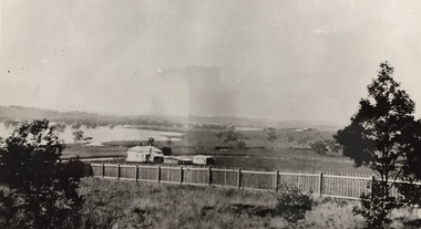
Photograph - Yarra in Flood - Belford & Kilby Farms, 1903
The Yarra Valley in what was previously called North Kew, but is now East Kew, was frequently subjected to flooding. Apart from some development on higher ground, the City of Kew regularly introduced restrictions on development and the building of housing in the area because of flood levels. Panoramic photographic positive of North Kew where the Belford and Kilby Farms were located on the south side of the Yarra River. This photo is a copy of the original photo in the collection.floods -- yarra -- 1903, kew golf course, greenacres golf course -
 Kew Historical Society Inc
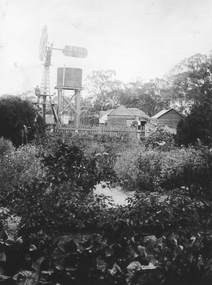
Photograph - Yarra Flats near Burke Road Bridge, 1937
Land along the Yarra River in Kew is now either designated open space, parkland or public golf links. By the 1930s much of this area remained open farmland, bought at auction for dairy farming in the 1840s.Original, black and white positive print of what is said to be the Yarra Flats near Burke Road Bridge. On the horizon, building can be seen, whereas in the middle ground, farm fencing and a windmill are the main features as well as remnant Eucalypts. Inscribed verso: "Yarra Flats near Burke Rd Bridge 1937" studley park -- kew (vic.) -
 Friends of Westgarthtown
Painting, John Borrack, Ziebells, German Lane, South View
Painted from Gardenia Road. The extensive farm complex on the right. (Western side of Gardenia Road). was demolished in 1972 for housing development. Buildings shown are cowshed, hay barn, engine shed and stables. Painted in the late afternoon, the lengthening shadows and lowering sky, could presage the ominous fate awaiting the farm with development. The Ziebell Farm was known as “The Pines†and sadly none of the many that proliferated there remain. Today they would be equivalent to those at the cemetery, having been planted at the same time. Provenance: John Borrack CollectionWatercolour depicting Ziebell Farmhouse from the north, Thomastown and Mernda. In gold frame with cream border.Artist signature: John Borrack; 70's Ziebells German Lane South Viewillustrations, watercolours, john borrack, ziebell, watercolour, painting -
 Stawell Historical Society Inc
Photograph - Yard Scenes at 'Whitehall', Hutchings Farm “Whitehall” -- 3 Photos
Hutchings family property “Whitehall” 3 Scenes Shows large Haystacks Sheds Cows extensive Garden. Avenue of trees. These copies were taken from the Hutchings Family album.Three (3) Sepia Photographs. 204 Titled Whitehall Avenue: An avenue with wooden fences including people on on left three on right including one woman. 204.1 Titled Yard at Whitehall: 4 Men with herd of cows in foreground, man in front holding a metal bucket. Large Hay stacks behind. wooden shed with metal roof on right. 204.2 Part of Whitehall: Windmill and wooden buildings behind Wooden Picket fence in background. 204: Whitehall Avenue 204.1 Yard at Whitehall 204.2: Part of Whitehall All enclosed in a box, which is above a line of solid triangles over a thin linestawell -
 Stawell Historical Society Inc
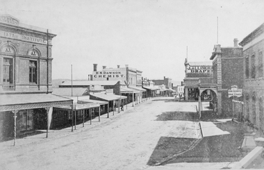
Photograph, Upper Main Street Stawell looking West with the Mechanics institute built in 1875 1878
Upper Main Street looking West from Mechanics Institute built in 1875. Mechanics Institute, Joseph Dawe Stawell Meat Market, D.B. O'Callaghan, Boot & Shoe Warehouse, Stawell Potato Depot, Ben S. Dawson Chemist, R.H. Wadsworth Jewler Watchmaker, English Scottish & Australian Bank, Bone Saddler, Hunter Bull & Mouth Hotel. On North side of street is J. Allingham Draper, Chadwick & Co Draper, D. Telford Farm Produce, Bank of Victoria. Photo taken 1878The "Top End" of Main Street. looking west. The Mechanics Insitute on the Left dates the photo about 1880. Some of the larger buildings have been restored.Victorian Views. C. Herbert, Photo. Stawell 1878stawell business streetscape -
 Surrey Hills Historical Society Collection
Photograph, Coach house at 'St Abbs', 33 York Street, Mont Albert
The photo is of the coach house at 'St. Abbs', 33 York Street. John Inglis Lothian, publisher, bought St Abbs in 1903 and lived here with his family until 1908. Prior to this the property had been part of Isiah Ainger's farm. The San Miguel family lived there from 1911-1923 and in 1926 Thomas Lothian bought 'St Abbs' and his family lived there until 1974. As the donor was Miss Jean Lothian it is assumed that the photo was taken during one of the periods the Lothian family occupied the property and more likely during the earlier period. A black and white photograph of a wooden building with a number of doors and windows with lattice work in place of glass. There is a concrete area in front of the building and a ladder leaning up against the building at the right hand end.york street, surrey hills, 'st abbs', house names, san miguel family, ainger farm, lothian family, coach house, isiah ainger, thomas lothian, john inglis lothian -
 Surrey Hills Historical Society Collection
Compact disc, Melbourne Directory 1884 (Sands & McDougall)
The Sands and McDougall directories are amongst the most comprehensive. You can find out more details about places in which people lived, the other residents in the area, the services available in the region...all of which help to paint a picture of your ancestors' life. Apart from the Street, Alphabetical, Trade and Professional directories, this volume also contains Government and Official, Ecclesiastical, Legal, Municipal, Colonial, Societies and Institutions directories. A fascinating feature in this volume is a Universal Building Societies Supplement which includes 15 pages of architectural house plans of the day - layouts and elevations - with the house price for each.The Sands and McDougall directories are amongst the most comprehensive. You can find out more details about places in which people lived, the other residents in the area, the services available in the region...all of which help to paint a picture of your ancestors' life. Apart from the Street,Alphabetical, Trade and Professional directories, this volume also contains Government and Official, Ecclesiastical, Legal, Municipal, Colonial, Societies and Institutions directories. A fascinating feature in this volume is a Universal Building Societies Supplement which includes 15 pages of architectural house plans of the day- layouts and elevations- with the house price for each.streets, trade, agriculture, government, legal, ecclesiastical, farmers, farm workers, clergy, plans, timber houses, brick dwellings, buildings, structures and establishments -
 Vision Australia
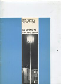
Administrative record - Text, 76th Annual Report 1971 Association for the Blind of Victoria, 1972
Articles in annual report include: branch committees, President's report, finance report, balance sheet, auxiliaries, volunteer service groups, in answer to your questions, senior staff, life governors, building of Katharine Rose wing at Bendigo, donation by G.W. Vowell of a 20 acre farm at Mt Eliza, new auxiliaries formed at Brighton, Kooyong, Bendigo and Mt Eliza with Guiding Light Group comprised of solely men, thanks to Flora Douglas for use of her home at Frankston and Audrey Moffat accepting responsibility for volunteer recruitment, and John Watson, a resident of Elanora, turned 100. 1 volume of text, photographs and illustrationsassociation for the blind, john watson, sir rohan delacombe, h.m. lightfoot, mirridong home (bendigo), kelaston home (ballarat), elanora home (brighton), annual reports -
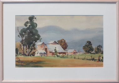 Federation University Art Collection
Watercolour, 'Valley Farm' by E. Vogel, 1956
This item was acquired for the Ballarat Teachers' College Collection in 1956. The Federation University Art Collection features over 1000 works and was listed as a 'Ballarat Treasure' in 2007.Framed watercolour landscape showing building structures surrounded by paddocks.art, artwork, vogel, e. vogel, available, landscape, farm -
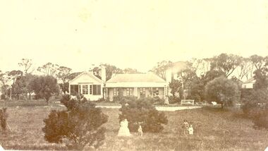 Port Fairy Historical Society Museum and Archives
Photograph
... by Horace Flowers Esq leura h flowers esq House station farm princes ...Leura Station homestead owned by Horace Flowers EsqBlack and white photograph of Leura station homestead with several women and children standing outsideleura, h flowers esq, house, station, farm, princes highway, building, horace -
 University of Melbourne, Burnley Campus Archives
Plan, Hilda Marriott ( Dance), Garden Plans by Hilda Marriott (Dance), 1947-1981
Set of 8 plans, including blue-prints, of various gardens, dated c. 1947 - 1981. See paper catalogue for complete list.Plans by Hilda Marriott Dance (1) Sketch plan and 2 blueprint copies of School of Horticulture Burnley. Garden Alterations New Building Area, Working Drawing by H. Dance, Scale ⅟₂₀"=1', 2/4/47, on reverse handwritten,"Proposed Garden Lay-out for New School Building (H. Dance-plan)." (NB Emily Gibson was also involved in the planning of this site.) (2) Tracing paper, paper and blueprint copies of Ararat & District Hospital Garden Plan - MacDonald Memorial & Court, Landscape Architect - H. Dance, Scale 1 inch=8 feet. Includes handwritten note, "Replacement for Ararat Hospital Nov. 1979," list of plants. (3) Blueprint Proposed Design for Garden Watermill Farm, Newbury for Norman Gadsden Esq., Scale ⅟₄₀"=1 ft. (4) Sketch Plan for Garden, Barcombe, Buangor - January 1981 by Hilda Marriott, Scale - Approximate Only - 1:40. (5) Tracing paper copy of plan of Garden at Plumhill, Templestowe, for Mr. & Mrs. Colin Smith. Hilda Dance, Designer 26/4/47, Scale ⅛"=1'. (6) Blueprint Garden House - Sketch. (7) Tracing paper and paper copies Ararat Medical Centre Courtyard Garden, Landscape Architect - Hilda Marriott, Scale - 1:25, Date 8.5.79. (8) Tracing paper copy National Trust of Australia (Victoria) The Heights, Newtown, Geelong Garden Plan, Scale 1:250, Drawn by - Hilda Marriott, Date 12.10.79.(1): on reverse handwritten,"Proposed Garden Lay-out for New School Building (H. Dance - plan)." (2): Includes handwritten note, "Replacement for Ararat Hospital Nov. 1979," list of plants.hilda marriott ( dance), burnley school of horticulture, students -
 Port Fairy Historical Society Museum and Archives
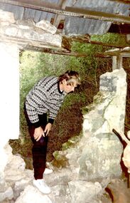
Photograph, Arthur Hoey Albert Rd 1992, 1992
Arthur Hoey, a Port Fairy Builder inspecting the ruins of a cottage on Albert Road. Arthur went on to restore the cottage. Research done by family found that the house a t one stage belonged at one time to Chidley a photographer . Further information also to hand mentions the area being used by Stan Chidley for a "scent farm". Several types of herbs and flowers were being grown thereColoured photograph of Arthur Hoey standing in a hole in the wall of the cottagecottage, building, home, house, albert road, scent farm -
 Port Fairy Historical Society Museum and Archives
Photograph, Albert Rd NS Section house removed c1995
This house in Albert Road Port Fairy North was bought and removed by the Victorian Government to make way for a new section of the Princes Highway that was to loop around and bypass the town. It was last owned and farmed by Claude and Katrine Brown. Katrine was the library teacher at the Consolidated School in the 1960's.coloured photographcottage, building, home, house, port fairy north, albert road -
 Mrs Aeneas Gunn Memorial Library
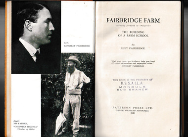
Book, Paterson Press, Fairbridge Farm : the building of a farm school, 1948
... Fairbridge Farm : the building of a farm school.... Fairbridge Farm : the building of a farm school Book Paterson Press ...A tale of the troubles, trials and vicissitudes of the Fairbridge Farm SchoolIll, p.189.non-fictionA tale of the troubles, trials and vicissitudes of the Fairbridge Farm Schoolchild migrants, school farms - western australia -
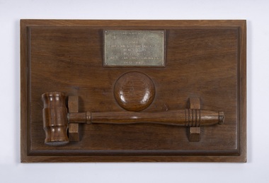 Bacchus Marsh & District Historical Society
Ceremonial object, Presentation Gavel and Sound Block presented to Shire of Bacchus Marsh in Memory of Alec William Bond, 1968
Alec William Bond was Secretary and Engineer for the Shire of Bacchus Marsh from 1924 until his death in 1968. The position of Secretary was similar to a Chief Executive Officer in contemporary terminology. Mr Bond was a prominent figure in the Bacchus Marsh community for nearly 50 years and as Shire Engineer was responsible for the design of a number of local infrastructure projects including the buildings and water scheme at the Lady Northcote Children's Farm at Glenmore and the public swimming pool in Grant Street, A physical memento that recognises the long and notable contributions of an important local government official and their service to the Bacchus Marsh Shire and community.A sound block with a green felt base and inscribed brass plaque with accompanying small hardwood mallet in a cradle.Engraved text on a brass plaque which reads: Presented by May Bond and Family to the Shire of Bacchus Marsh in memory of Alec William Bond Shire Secretary & Engineer 1924 – 1968.alec william bond, bacchus marsh shire council, gavel and sound blocks, local officials and employees, local government -
 Melton City Libraries
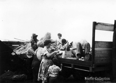
Photograph, Harvest, 1961
At harvest time farmers had relied on itinerant teams of workers descending on the district looking for work. The three Barrie brothers on their adjoining farms combined forces to cut their crop at its optimum time while the weather was in their favour. Up to many 20 workers at times formed a team in earlier times. Agricultural university students were also keen to gain practical experience in the field. Each of the brothers had a particular skill, and Tom Barrie was the expert on stack building. The district haystacks had a distinctive shape and could be recognised by their builder. Harvesting at Ferris Road, Meltonpioneer families, local identities, agriculture