Showing 1135 items matching " east kew"
-
 Kew Historical Society Inc
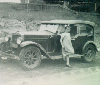
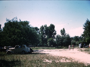
Photograph - Jane Coade and the Family Car, 1953
... 52 Frater Street -- Kew East(Vic.)..., outside 52 Frater Street, Kew East. The photographer was Mrs Doris... the house built for them. 52 Frater Street -- Kew East(Vic.) Coade ...52 Frater Street was the home of the Coade family who had the house built for them. Photograph of Jane Coade and 'Gert', the family car, outside 52 Frater Street, Kew East. The photographer was Mrs Doris Coade. Verso: "Jane & Gert / Nov. 1953"52 frater street -- kew east(vic.), coade family, jane coade -
 Kew Historical Society Inc
Plan - Subdivision Plan, Kewdene Estate, 1937-1939
... belmore road -- kew east (vic.)... of the City of Melbourne. Most of these are of Kew, Kew East ...Pru Sanderson, in her groundbreaking ‘City of Kew Urban Conservation Study : Volume 2 - Development History’ (1988), summarised the periods of urban development and subdivisions of land in Kew. The periods that she identified included 1845-1880, 1880-1893, 1893-1921, 1921-1933, 1933-1943, and Post-War Development. These periods were selected as they represented periods of rapid growth or decline in urban development. An obvious starting point for Sanderson’s groupings involved population growth and the associated economic cycles. These cycles also highlighted urban expansion onto land that was predominantly rural, although in other cases it represented the decline and breakup of large estates. A number of the plans in the Kew Historical Society’s collection can also be found in other collections, such as those of the State Library of Victoria and the Boroondara Library Service. A number are however unique to the collection.The Kew Historical Society collection includes almost 100 subdivision plans pertaining to suburbs of the City of Melbourne. Most of these are of Kew, Kew East or Studley Park, although a smaller number are plans of Camberwell, Deepdene, Balwyn and Hawthorn. It is believed that the majority of the plans were gifted to the Society by persons connected with the real estate firm - J. R. Mathers & McMillan, 136 Cotham Road, Kew. The Plans in the collection are rarely in pristine form, being working plans on which the agent would write notes and record lots sold and the prices of these. The subdivision plans are historically significant examples of the growth of urban Melbourne from the beginning of the 20th Century up until the 1980s. A number of the plans are double-sided and often include a photograph on the reverse. The advertisement for the ‘Kewdene Estate’ subdivision is pasted over a photograph of a property for sale. This is typical of the reuse of promotional materials in the period during, and subsequent to World War I. The subdivision included 14 lots bordered by Belmore Road, Birtles Street and Giles Street. On the other side of the subdivision [Glass] Creek is noted. The subdivision plan also shows part of the Outer Circle Railway and Deepdene Railway Station.subdivision plans - east kew, kewdene estate, belmore road -- kew east (vic.), giles street -- kew east (vic.) -
 Kew Historical Society Inc
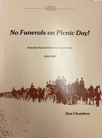
Book, Don Chambers, No funerals on picnic day! : Victorian funeral industry associations, 1890-1990, 1990
... East Kew, Vic. : Australian Funeral Directors Association... undertakers and undertaking -- victoria -- history. East Kew, Vic ...East Kew, Vic. : Australian Funeral Directors Association Victorian Division, 1990. xiv, 157 p. : ill. ; 28 cm. Includes index. Available from The Association, 722 High St, East Kew Vic 3102. Bibliography: p. 135.non-fictionundertakers and undertaking -- victoria -- history. -
 Kew Historical Society Inc
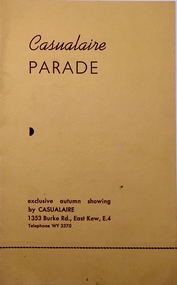
Programme, Casualaire Parade, Undated
... , 1353 Burke Road, East Kew, compered by Gwynne Harrison... Road, East Kew, compered by Gwynne Harrison Casualaire Parade ...The Kew Recreation Hall (1880-1960 was a major venue for civic events, exhibitions, theatre, concerts and in this case a commercial fashion parade.Arthur Henry Dear was an employee of the City of Kew, acting as Hall Keeper of the Kew Recreation Hall in Wellington Street, and later the new Kew City Hall in Cotham Road. The Arthur Dear Collection contains memorabilia - tickets, programmes, invitations - as well as his identification badge. Items in the collection dates from the 1940s to the 1970s. The Kew Recreation Hall (Wellington Street) and later the Kew City Hall (Cotham Road) were major locations in suburban Melbourne in the postwar period for civic and private events including theatre productions and exhibitions. The Arthur Dear Collection (in conjunction with the scrapbooks compiled by Marion Tilley) provide a comprehensive snapshot of performing arts in Kew during the 1940s, 1950s and 1960s. The collection includes valuable data about performances, performers, directors etc., during this period. Programme for an exclusive Autumn showing by Casualaire, 1353 Burke Road, East Kew, compered by Gwynne Harrisonfashion - kew, casualaire, gwynne harrison, valerie jacobson, lyle sampson, joan heathfield, mary rose campbell, marie johnson, arthur dear collection, kew recreation hall -- wellington street -- kew (vic.) -
 Kew Historical Society Inc
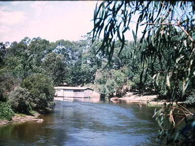
Photograph - Chipperfield's floating 'Pontoon' on the Yarra River, Ron Setford, 1960
... Yarra River -- Kew East (Vic.)... Avenue, East Kew, from c.1946 to c.1995. A keen photographer, he... Avenue, East Kew, from c.1946 to c.1995. A keen photographer, he ...Ron Setford and his wife Grace Setford lived in Tanner Avenue, East Kew, from c.1946 to c.1995. A keen photographer, he recorded the changing face of Kew over a 20 year period. Apart from 30 photographs of built structures and places in Kew dating from 1960 and 1961, 145 of his 35mm colour slides chronicle the development of the Eastern Freeway through the Yarra Valley over a five year period from c.1972 to c.1977. This important collection was donated to the Society by his granddaughter in 2025.This collection of 175 35mm slides is of local and statewide significance, owing to its subject matter, particularly the major development of road transport infrastructure during the 1970s with the construction of the Eastern Freeway. The photographer also took care to annotate and date most of his slides which enable the researcher to pinpoint temporal and spatial locations.Nilron setford, photographs -- kew (vic.) -- 1960s, yarra river -- kew east (vic.), chipperfield's boat house, chipperfield's floating pontoon -
 Kew Historical Society Inc
Photograph - Beach near Chipperfield's floating 'Pontoon', Ron Setford, 1960
... Yarra River -- Kew East (Vic.)... Avenue, East Kew, from c.1946 to c.1995. A keen photographer, he... Avenue, East Kew, from c.1946 to c.1995. A keen photographer, he ...Ron Setford and his wife Grace Setford lived in Tanner Avenue, East Kew, from c.1946 to c.1995. A keen photographer, he recorded the changing face of Kew over a 20 year period. Apart from 30 photographs of built structures and places in Kew dating from 1960 and 1961, 145 of his 35mm colour slides chronicle the development of the Eastern Freeway through the Yarra Valley over a five year period from c.1972 to c.1977. This important collection was donated to the Society by his granddaughter in 2025.This collection of 175 35mm slides is of local and statewide significance, owing to its subject matter, particularly the major development of road transport infrastructure during the 1970s with the construction of the Eastern Freeway. The photographer also took care to annotate and date most of his slides which enable the researcher to pinpoint temporal and spatial locations.Nilron setford, photographs -- kew (vic.) -- 1960s, yarra river -- kew east (vic.), chipperfield's boat house, chipperfield's floating pontoon -
 Kew Historical Society Inc
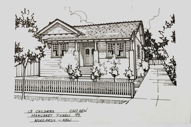
Drawing - Property Illustration, Margaret Picken, 13 Childers Street, Kew, 1989
... 13 CHILDERS EAST KEW / MARGARET PICKEN '89 / WOODARDS ~ KEW... EAST KEW / MARGARET PICKEN '89 / WOODARDS ~ KEW Pen and ink ...After training as a Cartographic Draftsman within the mining industry, I worked as a property illustrator for real estate firms in the eastern suburbs of Melbourne for 23 years from 1983. I initially photographed houses with a Polaroid camera and made a 'thumbnail' sketch while there. The photos were used to scale off a sketch in pencil and then that sketch was overlaid with drafting film and the 'pen and ink' completed. The pens I used were the Rotring ‘Rapidigraph’ drafting pens. The ink was also made by Rotring (German).The film was ‘Rapidraw’, polyester drafting film, double matte. It takes a very fine line and doesn’t bleed. As well as house sketches, there were often floor plans and site plans ordered. Aerial sketches were ordered when the property needed an overall view. (Margaret Picken, 2020)This drawing is one of a series created by Margaret Picken for real estate agents in Melbourne between 1983 and 2006. Each work is signed and dated by the artist.Gift of Margaret Picken, 2020Pen and ink drawing on drafting film of 13 Childers Street, Kew by Margaret Picken.13 CHILDERS EAST KEW / MARGARET PICKEN '89 / WOODARDS ~ KEWartist -- margaret picken 1950-, property illustrations — buildings — kew (vic.), 13 childers street - kew (vic) -
 Kew Historical Society Inc
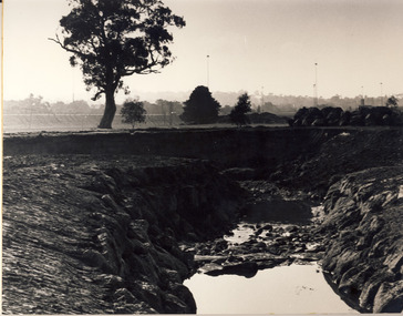
Photograph - Flooding of the Yarra Valley at Kew, 1974
... of the Yarra bordering Kew and Kew East in the north and west... land at East Kew under floodwater on 16 May 1974... bordering Kew and Kew East in the north and west of the municipality ...Flooding of the Yarra Valley, including that section of the Yarra bordering Kew and Kew East in the north and west of the municipality, was a regular occurrence. Extreme flood events of the Yarra River are recorded to have occurred in 1891, 1901, 1916, 1923 and 1934. The Municipality of Kew's response to these floods was to enact planning decisions restricting residential development in flood prone areas following the floods of 1916, 1921 and 1934. While floods continued after the development of the Upper Yarra Reservoir (construction 1948-57), the regularity and extent of these inundations diminished. During the nineteenth century, the land abutting the south side of the Yarra in Kew was devoted to dairy farming. In the twentieth century, before and after the construction of the Eastern Freeway, much of this low-lying area was used as golf courses and public parks.Late example of the capacity of the Yarra Valley at Kew to flood, even though drainage works and the Upper Yarra Reservoir had reduced their regularity.Original black and white print photograph of the low-lying land at East Kew under floodwater on 16 May 1974. The photograph is taken from 43 Kellett Grove.Annotation verso: "Kellett Gve No.43 / Flood Level / 16 May 1974 11.40am"floods, yarra river, kellett grove -
 Kew Historical Society Inc
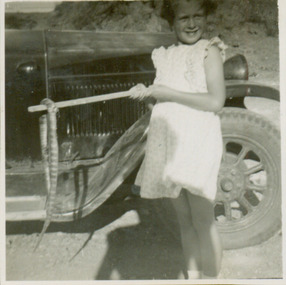
Photograph - Jane Coade and a Tiger Snake, 1950
... 52 Frater Street -- Kew East(Vic.)...Photograph of Jane Coade outside 52 Frater Street, Kew East... the house built for them. 52 Frater Street -- Kew East(Vic.) Coade ...52 Frater Street was the home of the Coade family who had the house built for them. Photograph of Jane Coade outside 52 Frater Street, Kew East. She is standing by the family car with a dead tiger snake on a stick. The photographer was Mrs Doris Coade. Verso: "Jane / March 1952 / Aged 6 yrs 11 mths"52 frater street -- kew east(vic.), coade family -
 Bendigo Historical Society Inc.
Photograph - WES HARRY COLLECTION: STUDIO PHOTOGRAPH OF ROY PRINCE WITH CHINESE WOODEN CHAIR
... East Kew Undated Photo by Irving Harry, Melbourne..., of Clyde Street East Kew Undated Photo by Irving Harry, Melbourne ...black & white photograph of Roy Prince, of Clyde Street East Kew Undated Photo by Irving Harry, MelbourneIrving Harry, Melbourne -
 Kew Historical Society Inc
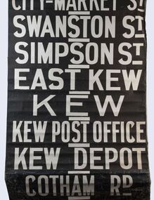
Functional object - Destination Roll, Melbourne & Metropolitan Tramways Board, 1960s
... East Kew, Kew, Kew Post Office, Kew Depot, and Cotham Road.... / Swanston St / Simpson St / East Kew / Kew / Kew Post Office / Kew... / East Kew / Kew / Kew Post Office / Kew Depot / Cotham Rd / Malv ...In an era predating the computerisation of equipment on public transport, where trams in Melbourne were driven by drivers and conductors sold fares, destinations were shown at the front and rear of the tram within a glazed box. A driver adjusted the roll to select each new trip destination. Given the length of rolls, in this case approximately nine metres, this could be a time consuming process. In addition to the named destination roll, each tram included a separate roll listing the route numbers.The roll was purchased at a Leski Auction in Armadale as part of a large group of tramways memorabilia including tram 'rolls' from New South Wales, Victoria, South Australia and Tasmania. The auction house described the collection as "The collection of destination blinds or rolls that forms the core of the Railways Trams & Buses Section (Lots 655 – 732) is the best we have ever offered and represents a life-time of collecting by an Adelaide enthusiast, now deceased." Melbourne & Metropolitan Tramways Board Tramways Destination Roll. Black and white paint on linen roll. Forty-eight named destinations including four depots - Camberwell, Hanna Street, Hawthorn, Kew. Multiple destinations in what is now the City of Boroondara (Kew, Hawthorn and Camberwell); including East Kew, Kew, Kew Post Office, Kew Depot, and Cotham Road.Named destinations beginning to end: “Olympic Park / Special / Football / Racecourse / Richmond / Burnley / Riversdale / Wattle Park - Warragul Rd / Wattle Park - Elgar Rd / City / Burwood / Hartwell / Bowen St / Camberwell Depot / Camberwell Jucn / Leura Grove / Gardener / Glenferrie Rd / Chapel St / St Kilda Rd / Camberwell / City / Lonsdale St / University / City via William St / Domain Rd / Hanna St Depot / South Melb & St Kilda Beach / Prahran / North Richmond / Windsor / Hawthorn Depot / Hawthorn / Spencer St / Toorak Rd / Swan & Church St Cnr / North Balwyn / City Flinders & Spencer Sts Corner / City - Market St / Swanston St / Simpson St / East Kew / Kew / Kew Post Office / Kew Depot / Cotham Rd / Malv Tn Hall"melbourne & metropolitan tramways board -
![Photograph - Construction of the F19 [Eastern Freeway], Ron Setford, 1971](/media/collectors/550653872162f11fb04854aa/items/67cbd1c0494c4da380441bb3/item-media/67cbd350494c4da380442242/item-fit-380x285.jpg) Kew Historical Society Inc
Kew Historical Society IncPhotograph - Construction of the F19 [Eastern Freeway], Ron Setford, 1971
... Avenue, East Kew, from c.1946 to c.1995. A keen photographer, he..."Royal Talbot, left to Kew East, right to Alphington"... Avenue, East Kew, from c.1946 to c.1995. A keen photographer, he ...Ron Setford and his wife Grace Setford lived in Tanner Avenue, East Kew, from c.1946 to c.1995. A keen photographer, he recorded the changing face of Kew over a 20 year period. Apart from 30 photographs of built structures and places in Kew dating from 1960 and 1961, 145 of his 35mm colour slides chronicle the development of the F19 (later renamed Eastern) Freeway through the Yarra Valley in Kew over a five year period from c.1972 to c.1977. This important collection was donated to the Society by his granddaughter in 2025.This collection of 175 35mm slides is of local and statewide significance, owing to its subject matter, particularly the major development of road transport infrastructure during the 1970s with the construction of the Eastern Freeway. The photographer also took care to annotate and date most of his slides which enable the researcher to pinpoint temporal and spatial locations."Royal Talbot, left to Kew East, right to Alphington"ron setford, eastern freeway, f19 freeway -
 Kew Historical Society Inc
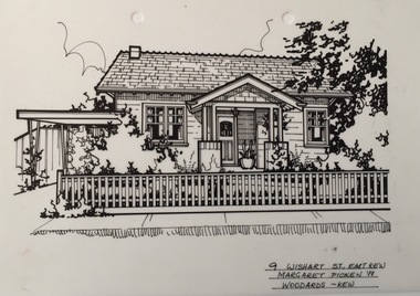
Drawing - Property Illustration, Margaret Picken, 9 Wishart Street, Kew, 1988
... 9 WISHART ST., EAST KEW / MARGARET PICKEN ~88 / WOODARDS...., EAST KEW / MARGARET PICKEN ~88 / WOODARDS ~ KEW Pen and ink ...After training as a Cartographic Draftsman within the mining industry, I worked as a property illustrator for real estate firms in the eastern suburbs of Melbourne for 23 years from 1983. I initially photographed houses with a Polaroid camera and made a 'thumbnail' sketch while there. The photos were used to scale off a sketch in pencil and then that sketch was overlaid with drafting film and the 'pen and ink' completed. The pens I used were the Rotring ‘Rapidigraph’ drafting pens. The ink was also made by Rotring (German).The film was ‘Rapidraw’, polyester drafting film, double matte. It takes a very fine line and doesn’t bleed. As well as house sketches, there were often floor plans and site plans ordered. Aerial sketches were ordered when the property needed an overall view. (Margaret Picken, 2020)This drawing is one of a series created by Margaret Picken for real estate agents in Melbourne between 1983 and 2006. Each work is signed and dated by the artist.Gift of Margaret Picken, 2020Pen and ink drawing on drafting film of 9 Wishart Street, Kew, by Margaret Picken.9 WISHART ST., EAST KEW / MARGARET PICKEN ~88 / WOODARDS ~ KEWartist -- margaret picken 1950-, property illustrations — buildings — kew (vic.), 9 wishart street -- kew (vic.) -
 Kew Historical Society Inc
Photograph, Stewart West, Kew Junction Looking West along High Street, 1995
... High Street, Kew, looking east from Kew Junction. c. 1995... High Street, Kew, looking east from Kew Junction. c. 1995 Kew ...Photo created for a display about Kew comparing old (19th) and new (20th century) photographsProvides a picture of High Street Kew in the decade following the second widening of High Street in the 1950s.High Street, Kew, looking east from Kew Junction. c. 1995high street (kew), kew junction, stewart west -
 Glen Eira Historical Society
Document - Murrumbeena State School No. 3449
... East Kew Primary School... Carnegie State School East Kew Primary School Andrew Ward ...This file contains a photocopy of entry for Murrumbeena Primary School from a Caulfield Conservation Study by Andrew Ward, March 1995, noted in study are site address, a description of the building’s structure, history, references and statement of significance. Also in this file is a typed history of Murrumbeena Primary School with added hand – written notations. There is not author and it is undated.murrumbeena primary school, rosstown state school, multi – purpose hall, murrumbeena state school, gippsland railway, enrolment, hobart road murrumbeena, presbyterian church hall, out of school hours., statement of significnace, carnegie state school, east kew primary school, andrew ward., victorian public works department, staff and administration, maintenance. -
Glen Eira Historical Society
Document - Bakewell Family
... . Kilda Elsternwick Inkerman Street St. Kilda East Kew Memoirs ...There are 3 items about this family of early European settlers in Victoria: 1/A photocopy of an extract “Early Pioneer Families of Victoria and Riverina” – Henderson Page 441-442 The Bakewell Family of Burnewang and Tooradin”. It includes a photo of John Bakewell (1807-1888). It contains two pages and describes Bakewell’s property expansion. 2/An original copy of handwritten, unsigned undated research notes on John Bakewell property holdings taken from St Kilda Rate Book (1859-1873). It describes the land allotment. 3/A typed, unsigned, undated extract from 'The Howitts in Australia by Mary Howitt' - Mary Howitt, Vic Hist Mag 1913 Vol 3 No. 1. Reference – Memoirs of a Stockman, Harry Peck, 1853 Map, Foot Plot CCXLVI at Kooyong & Glen Eira Road. It provides a brief outline of the lives of brothers Robert and John Bakewell.the bakewell family, early pioneer families, henderson, bakewell john, port phillip, burnewang, bakewell robert, howitt godfrey dr, lord goderich, tooradin, phoebe, friends' school ackworth, yorkshire, nottingham, shaw john wyberg, plenty river, businesses, goldsbrough richard, goldsbrough mort and company ltd., glaziers, squatters, burnewang, mantons, tooradin, red bluff, torbinurruck, great swamp, brenanah, westernport, numerella, snowy river, orbost, green hills b, caramut, lyall william, mickle john, buckland john, notts, england, balderton, weddings, jane emily, howitt emanuel, farnsfield, lever mary, howitt thomas, heanor, derbyshire, howitt godfrey, scales john, exeter college oxford, downing college cambridge, guerard von, wayne john, south warnborough manor, harrison robert, lord john, jamaica, mary alice, dr. miller, miller john francis compton, emmie joan, mary emily, clifton hotel welbeck street, phoebe alice, anne edith, british museum, land values, settlements, st. kilda, elsternwick, inkerman street, st. kilda east, kew, memoirs of a stockman, harry peck -
Canterbury History Group
Document - Re-opening the Outer Circle Railway Line, J.Kemp Government Printer, 1909
... East Kew... railway Victorian Railways Deepdene East Kew Victorian Government ...Report by the Parliamentary Standing Committee on Railways on the question of Re-opening the Outer Circle Railway LIne.canterbury, railways standing committee, outer circle railway, victorian railways, deepdene, east kew, victorian government -
 Melbourne Tram Museum
Photograph - Burke Road and High Street, North Balwyn Trackwork, The Met, c1980
... East Kew... Reconstruction East Kew MMTB Tower Trucks On rear of photograph in ink ...Photograph of the intersection of Burke Road and High Street, North Balwyn, looking back towards Kew and the city. Shows the inbound section of track being rebuilt, using a temporary track deviation method. Two trams can be seen on this track. Also note the additional temporary overhead lighting install above the track relay. Photo c1980. Has Kevin Donnellan tyre and a Mobil service station in the view. The overhead work being done by two bucket trucks.Yields information about High St North Balwyn and track reconstruction.Black and White Photograph with notes on rear.On rear of photograph in ink "High St Balwyn ?"trams, tramways, high st, north balwyn, burke rd, tram track, reconstruction, east kew, mmtb, tower trucks -
 Kew Historical Society Inc
Certificate, Victorian Federation of Mothers Clubs, 1943-44, 1944
... kew east central mothers club... of Kew East Central Mothers Club listing her 11 years of service... by Members of Kew East Central Mothers Club listing her 11 years ...This work forms part of the collection assembled by the historian Dorothy Rogers, that was donated to the Kew Historical Society by her son John Rogers in 2015. The manuscripts, photographs, maps, and documents were sourced by her from both family and local collections or produced as references for her print publications. Many were directly used by Rogers in writing ‘Lovely Old Homes of Kew’ (1961) and 'A History of Kew' (1973), or the numerous articles on local history that she produced for suburban newspapers. Most of the photographs in the collection include detailed annotations in her hand. The Rogers Collection provides a comprehensive insight into the working habits of a historian in the 1960s and 1970s. Together it forms the largest privately-donated collection within the archives of the Kew Historical Society.Certificate presented by the Victorian Federation of Mothers Clubs. A bound certificate given to Mrs Rogers by Members of Kew East Central Mothers Club listing her 11 years of service. The bound certificate includes the autographs of the members of the club in 1943-44Signatureskew east central mothers club, victorian federation of mothers clubs, dorothy rogers -
 Kew Historical Society Inc
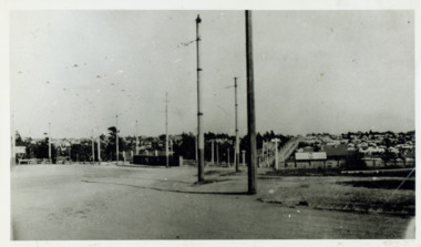
Photograph - Looking towards Kew from Strathalbyn Street and High Street, c.1916
... trams -- kew east..., about 1916. Courtesy Mrs E Bennett, Kew East / Property of Miss.... trams -- kew trams -- kew east mmtb M&MTB tramways harp junction ...An electrified tram route from Melbourne along High Street replaced an original Horse Tram that terminated at the Kew Cemetery. This new tram only reached the bridge over the Outer Circle railway at the Harp Junction. The line was later extended to North Balwyn.Black and white print positive showing the view west along High Street, Kew (formerly Bulleen Road). In the centre distance is the Boroondara General (Kew) Cemetery. In the foreground, the road crosses the Outer Circle railway. The photograph reflects the level of urbanisation in Kew during the First World War. "Looking towards Kew from Strathalbyn St / High St corner, about 1916. Courtesy Mrs E Bennett, Kew East / Property of Miss Foley"trams -- kew, trams -- kew east, mmtb, m&mtb, tramways, harp junction -
 Kew Historical Society Inc
Photograph - Kew City Council Rubbish Cart, 1940-1950
... driven garbage cart in East Kew owned by the City of Kew... positive of a horse driven garbage cart in East Kew owned ...The photo was taken in a period before motorised Council vehicles became commonplace. The 'wagon' predates the metal garbage trucks emblazoned with KCC, copies of which are in our collection.Small black and white photographic positive of a horse driven garbage cart in East Kew owned by the City of Kew. A council worker stands in front of the cart"Kew City Council Rubbish Cart / from E. Bentley"garbage collection -- kew (vic.), city of kew workers -
 Kew Historical Society Inc
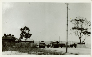
Photograph - Harp of Erin Tram Terminus, c.1916
... trams - kew east..., Kew East / Property of Miss Foley."... trams - kew trams - kew east "Harp of Erin Tram Terminus about ...An electrified tram route from Melbourne along High Street replaced an original Horse Tram that terminated at the Kew Cemetery. This new tram only reached the bridge over the Outer Circle railway at the Harp Junction. The line was later extended to North Balwyn.Black and white print positive of the Tram Terminus in High Street, Kew at the Harp of Erin hotel. "Harp of Erin Tram Terminus about 1916. House on left still standing behind delicatessen [in 1978]. / Courtesy Mrs E Bennett, Kew East / Property of Miss Foley."tramways, mmtb, tram terminus, no 48 tram route, harp of erin hotel, trams - kew, trams - kew east -
 Kew Historical Society Inc
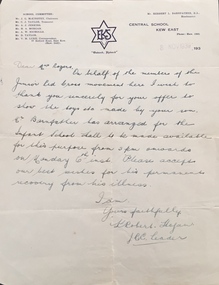
Document, Letter, to Mrs Rogers / from Junior Red Cross, 1939, 1939
... central school kew east.... The letter is on Central School Kew East letterhead.... red cross central school kew east dorothy rogers Letter ...This work forms part of the collection assembled by the historian Dorothy Rogers, that was donated to the Kew Historical Society by her son John Rogers in 2015. The manuscripts, photographs, maps, and documents were sourced by her from both family and local collections or produced as references for her print publications. Many were directly used by Rogers in writing ‘Lovely Old Homes of Kew’ (1961) and 'A History of Kew' (1973), or the numerous articles on local history that she produced for suburban newspapers. Most of the photographs in the collection include detailed annotations in her hand. The Rogers Collection provides a comprehensive insight into the working habits of a historian in the 1960s and 1970s. Together it forms the largest privately-donated collection within the archives of the Kew Historical Society.Letter to Dorothy Rogers from the Junior Red Cross. Letter to Mrs Rogers written in 1939 by Robert Hogan on behalf of the Junior Red Cross movement thanking her for the loan of toys made by her son and wishing him a permanent recovery from his illness. The letter is on Central School Kew East letterhead.junior red cross, central school kew east, dorothy rogers -
 Kew Historical Society Inc
Photograph, Burke Road Bridge, 1930s
... East Kew and Ivanhoe. The previous bridge, constructed in 1926... Bridge linking East Kew and Ivanhoe. The previous bridge ...Without bridges, Kew remained cut off from the City of Melbourne, only being accessible by Punt. Private and public bridges were constructed from the 1850s, beginning with the Hawthorn Bridge linking Bridge and Burwood Roads. A bridge across the Yarra at Burke Road was created as early as 1873. Since that first wooden bridge, a number of later bridges, typically on concrete pylons have been built, in 1926 and again during the 1970s.Sepia, faded photograph of the Burke Road Bridge linking East Kew and Ivanhoe. The previous bridge, constructed in 1926 was submerged beneath the flood waters in the 1934 mega-flood of the Yarra.burke road bridge (kew), bridges -- river yarra -
 Kew Historical Society Inc
Photograph, City of Kew, Glass' Creek, Hays Paddock, Kew, c.1980
... glass' creek - kew east (vic)...' creek - kew east (vic) hays paddock - kew east (vic) Enlarged ...One of a series of photos created for an exhibition by the City of Kew of notable locations. The photos represent a snapshot in time.Enlarged photograph mounted on board, donated to the Kew Historical Society by the City of Kew on 10 April 1991.glass' creek - kew east (vic), hays paddock - kew east (vic) -
Kew Historical Society Inc
Plan - Willsmere Park Estate, Kew, 1926
... subdivisions -- kew east (Vic.)... (Vic.) subdivisions -- kew east (Vic.) willsmere park -- Kew ...Subdivision plans and real estate flyers/brochures reveal a number of aspects of urban development and history. The Kew Historical Society's collection of these plans, as well as advertisements extracted from magazines, cover key aspects of community development and architectural history of Kew and Kew Eat as well as surrounding suburbs. While most of the plans in the collection were gifted to the Society by the former City of Kew, a number of other plans and advertisements have been donated by individuals, of which this is an example.Original 4-page, bifold subdivision plan of the Willsmere Park Estate, Kew. The 1926 land sale advertised '40 superb villa allotments' on the 'Yarra Heights'. Streets within the subdivision included: Willow Grove, Kilby Road, Elm Grove and Belford Road. The double page spread on pages 2 and 3 shows the detailed plan of the 40 lots, surrounded by public parkland [Willsmere Park] and the Kew Golf Links. By the time that this version of the plan was released, only the lots on Willow Grove and Kilby Road remained. willsmere park estate -- kew (vic.), subdivisions - kew (vic.), subdivisions -- kew east (vic.), willsmere park -- kew east (vic.) -
Kew Historical Society Inc
Plan - 30 Choice Home Sites in Kilby Road, Meldrum Street and Fairway Drive, 1965
... Subdivisions -- Kew East (Vic.)... this is an example. Subdivisions -- Kew East (Vic.) Subdivisions -- Kew (Vic ...Subdivision plans and real estate flyers/brochures reveal a number of aspects of urban development and history. The Kew Historical Society's collection of these plans, as well as advertisements extracted from magazines, cover key aspects of community development and architectural history of Kew and Kew Eat as well as surrounding suburbs. While most of the plans in the collection were gifted to the Society by the former City of Kew, a number of other plans and advertisements have been donated by individuals, of which this is an example.Original 4-page, bifold brochure, one of two in the collection, of home sites created following the creation of the Eastern Freeway which separated a section of land owned by the Kew Golf Club from the main course. The new estate featured 30 lots in Meldrum Street, Kilby Road and Fairway Drive. subdivisions -- kew east (vic.), subdivisions -- kew (vic.), kew golf club -
Kew Historical Society Inc
Plan - 30 Choice Home Sites in Kilby Road, Meldrum Street and Fairway Drive, 1965
... subdivisions -- kew east (vic.)... this is an example. subdivisions -- kew east (vic.) subdivisions -- kew (vic ...Subdivision plans and real estate flyers/brochures reveal a number of aspects of urban development and history. The Kew Historical Society's collection of these plans, as well as advertisements extracted from magazines, cover key aspects of community development and architectural history of Kew and Kew Eat as well as surrounding suburbs. While most of the plans in the collection were gifted to the Society by the former City of Kew, a number of other plans and advertisements have been donated by individuals, of which this is an example.Original 4-page, bifold brochure, one of two in the collection, of home sites created following the creation of the Eastern Freeway which separated a section of land owned by the Kew Golf Club from the main course. The new estate featured 30 lots in Meldrum Street, Kilby Road and Fairway Drive.subdivisions -- kew east (vic.), subdivisions -- kew (vic.), kew golf club -
Kew Historical Society Inc
Archive (Series) - Schools [Kew]
... Kew East Primary School – Kew (Vic.)... School – Kew (Vic.) Kew East Primary School – Kew (Vic ...Various PartiesReference, Research, InformationArranged by Secondary Values (value of records to users)Kew is home to many different education institutions, many longstanding with extensive histories. The oldest still running school, the Kew State Primary School, began in 1872, with many influential private schools such as Xavier College and Methodist Ladies College being built and established within the next decades. Kew (and Boroondara by extension) is well-known for its quality of schooling compared with the rest of Melbourne, as well as it’s priciness as many private schools compete for students in such a small area. Kew is also home to Preshil, the first school of its experimental kind in the state. The file includes: Advertisements for many of the schools in Kew through newspapers, multiple newspaper articles, and a history of schools in Kew.schools – kew (vic.), xavier college – kew (vic.), methodist ladies college – kew (vic.), kew primary school – kew (vic.), kew high school – kew (vic.), kew east primary school – kew (vic.), genazzano college – kew (vic.), carey baptist grammar – kew (vic.), preshil – kew (vic.)schools – kew (vic.), xavier college – kew (vic.), methodist ladies college – kew (vic.), kew primary school – kew (vic.), kew high school – kew (vic.), kew east primary school – kew (vic.), genazzano college – kew (vic.), carey baptist grammar – kew (vic.), preshil – kew (vic.) -
 Kew Historical Society Inc
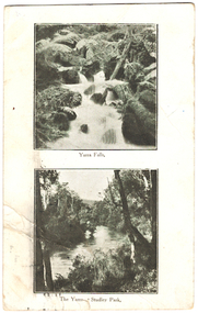
Postcard, Yarra Falls, The Yarra at Studley Park, 1920-1950
... "Mrs Clark, Harp Road, East Kew / Wishing Mother a very... postcards "Mrs Clark, Harp Road, East Kew / Wishing Mother a very ...The Yarra River was a major subject for the producers of postcards in Melbourne. This dual image postcard shows images of the Yarra in two locations. Studley Park in Kew was a major location for recreation activities by the people of Melbourne.Image of the Yarra at Sudley Park shows remnant vegetation preserved on the banks of the Yarra in this part of Kew.Monochrome postcard with two images of the Yarra River, the lower image showing the Yarra at Studley Park. The reverse has a handwritten birthday greeting from Eileen to her mother Mrs Clark. Original postage stamp has been removed and slight tearing in top right corner. Two ink stamps KEW HISTORICAL SOCIETY have been added."Mrs Clark, Harp Road, East Kew / Wishing Mother a very happy Birthday and many returns / from Eileen"yarra falls, dual image postcards, yarra river -- studley park -- melbourne (vic.), monochrome postcards