Showing 1076 items
matching eastern road.
-
 Ringwood and District Historical Society
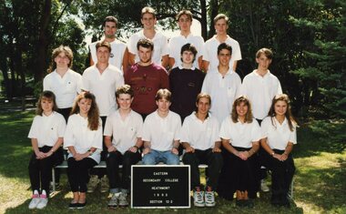
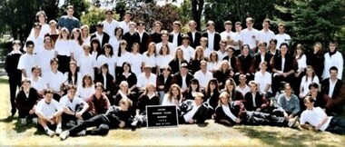
Photograph - Group, Eastern Secondary College 1992 Section 12.2, c 1992
Colour Photographrts, ringwood tech, esc -
 Ringwood and District Historical Society
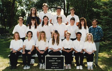
Photograph - Group, Eastern Secondary College 1992 Section 12.3, c 1992
Colour Photographrts, ringwood tech, esc -
 Ringwood and District Historical Society
Photograph - Group, Eastern Secondary College 1992 Section 12.4, c 1992
Colour Photographrts, ringwood tech, esc -
 Ringwood and District Historical Society
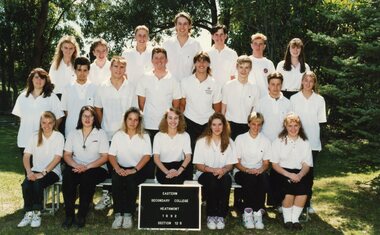
Photograph - Group, Eastern Secondary College 1992 Section 12.5, c 1992
Colour Photographrts, ringwood tech, esc -
 Ringwood and District Historical Society
Photograph - Group, Eastern Secondary College 1992 Section 12-ALL, c 1992
Colour Photographrts, ringwood tech, esc -
 Ringwood and District Historical Society
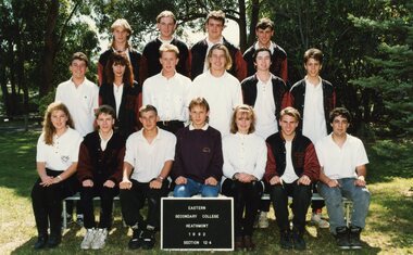
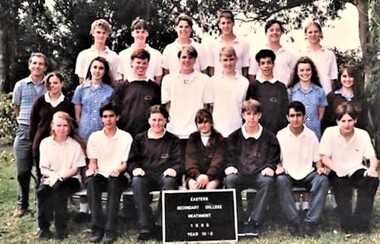
Photograph - Group, Eastern Secondary College 1993 Section 10.3, c 1993
Colour Photographrts, ringwood tech, esc -
 Ringwood and District Historical Society
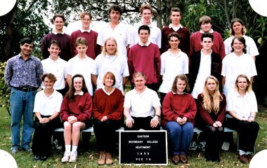
Photograph - Group, Eastern Secondary College 1993 Section VCE 1A, c 1993
Colour Photographrts, ringwood tech, esc -
 Ringwood and District Historical Society
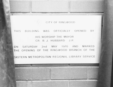
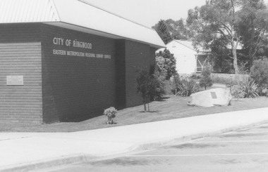
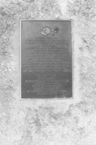
Photograph, Library plaque of official opening inscribed "City of Ringwood" 1970
This building was officially opened by His Worship The Mayor - Cr. B.J. Hubbard J.P. on Saturday 2nd May 1970 and marked the opening of the Ringwood branch of the Eastern Metropolitan Regional Library Service."Written on back of photograph, "Library plaque". -
 Ringwood and District Historical Society
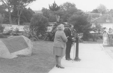
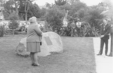
Photograph, Plaque unveiling at Ringwood Eastern Metropolitan Regional Library, Warrandyte Road, Ringwood on 26/10/1974, marking the Golden Jubilee of Ringwood's severance from Lilydale. Mrs. E Pullin, Ringwood Historical Group President (left), and Mayor, Cr. Stan Morris
Catalogue card reads, 'Library. Unveiling stone outside library to commemorate Matthew Flinders explorers and early graves of settlers, 1970'. Back of photograph reads, 'Unveiling of plaque, 1970. Cr. Stan Norris and E. Pullin'. -
 Ringwood and District Historical Society
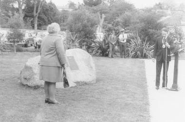
Photograph, Plaque unveiling at Ringwood Eastern Metropolitan Regional Library, Warrandyte Road, Ringwood on 26/10/1974, marking the Golden Jubilee of Ringwood's severance from Lilydale
Catalogue card reads, 'Library - unveiling stone outside library to commemorate Matthew Flinders explorers and early graves of settlers, 1970'. Written on back of photograph, '1970 - Rock and plaque, Cr. Stan Morris, Mayor'. -
 Ringwood and District Historical Society
Photograph, Plaque unveiling at Ringwood Eastern Metropolitan Regional Library, Warrandyte Road, Ringwood on 26/10/1974, marking the Golden Jubilee of Ringwood's severance from Lilydale
Catalogue card reads, 'Library unveiling stone outside library to commemorate Matthew Flinders explorers and early graves of settler, 1970'. Written on back of photograph, 'Library 1970'. -
 Ringwood and District Historical Society
Photograph, Plaque unveiling at Ringwood Eastern Metropolitan Regional Library, Warrandyte Road, Ringwood on 26/10/1974, marking the Golden Jubilee of Ringwood's severance from Lilydale
Written on back of photograph, 'Plaque and rock 1970. Ringwood Library'. Catalogue card reads, 'Library - Unveiling stone outside library to commemorate Matthew Flinders, explorers and early graves of settlers, 1970.' -
 Ringwood and District Historical Society
Photograph, Plaque unveiled at Ringwood Eastern Metropolitan Regional Library, Warrandyte Road, Ringwood on 26/10/1974, marking the Golden Jubilee of Ringwood's severance from Lilydale
Written on back of photograph, 'Plaque, 1970'. -
 Ringwood and District Historical Society
Photograph, Plaque unveiling at Ringwood Eastern Metropolitan Regional Library, Warrandyte Road, Ringwood on 26/10/1974, marking the Golden Jubilee of Ringwood's severance from Lilydale. Mrs. E Pullin, Ringwood Historical Group President (left), and Mayor, Cr. Stan Morris
Written on catalogue card, 'Library. Unveiling stone outside library to commemorate Matthew Flinders explorers and early graves of settlers, 1970.' Written on back of photograph, 'Mayor Cr. Stan Morris dedication rock plaque outside library 1970'. -
 Orbost & District Historical Society
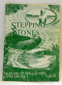
book, Stepping Stones, 1986
This book was compiled in 1983 by Chris Smyth, Isabel Baltvilks, Lorelle Roberts and Maurice Roberts for the Friends of Mallacoota as a guide to Victoria's eastern corner. Friends of Mallacoota is a group of volunteers, established in 1983, aiming to sustain the character of Mallacoota and its surrounds by protecting and caring for the natural environment. This book is a useful guide to Mallacoota's history and environment.A stapled, 40 pp, paperback book, titled "Stepping Stones A Guide to Mallacoota". The cover is green with a background drawing of a beach and river at Mallacoota. It is priced at $2.50. It contains descriptions, history, maps, black/white photographs and drawings.Stamped on inside cover - MAREEBA LODGE 59 MIRRABOOKA ROAD MALLACOOTA 3983 It has telephone details. mallacoota friends-of-mallacoota stepping-stones -
 Orbost & District Historical Society
book, Vic Roads Centenary 1913 -2013, 2013
... of major projects, which includes the Great Ocean Road, Hume... of major projects, which includes the Great Ocean Road, Hume ...The publication, VicRoads Centenary: Keeping Victorians Connected for 100 Years, looks at the people and projects that define VicRoads’ history. Written by current and former VicRoads’ employees, the publication details the organisation’s portfolio of major projects, which includes the Great Ocean Road, Hume Highway and Eastern Freeway. Other sections report on Victoria’s world-first road safety initiatives, VicRoads’ use of technology and sustainability measures. (ref VicRoads) This item is one of several books donated by David Jellie at a presentation to Orbost Historical Society. He was a contributor to the book and was the engineer for the Snowy River Bridge (Princes Highway) at Orbost 1974-1976.This book is a useful reference tool on the history of road construction in Victoria including East Gippsland.A thick, bound paperback book, titled "VicRoads Centenary Keeping Victorians Connected for 100 Years". On the front cover is a black/white photograph of two men working on a road. One has a pick. The book contains the history of VicRoads, photographs, maps and advertisements. Some are b/w. Others are coloured.vicroads book roads snowy-river-bridge jellie-david -
 Orbost & District Historical Society
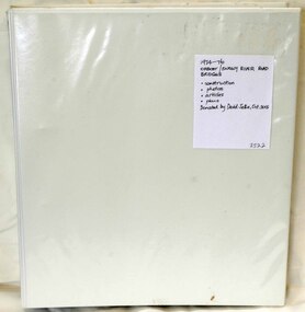
folder, Orbost Bridges - Snowy River Road Bridges, 1974 1976
This folder was compiled in October 2015 from documents, magazines. papers and photographs donated by David Jellie, engineer in charge 1974 - 1976. In early 1974, as an Engineer with the Country Roads Board, David came to Orbost as the Supervising Engineer for the construction of the new bridges which were part of an 8.4km Orbost bypass road design. This was a major project involving not only a new bridge over the Snowy River (including Lochiel Lagoon), but other bridges over Ashby’s Gulch and Watt’s Gulch. These new bridges were opened in November 1976 with the unveiling of a plaque on the eastern end of the $2.4M Snowy River Bridge. (ref. May Leatch)This item is a useful reference tool on the construction history of the Snowy River Road bridges.A white plastic folder - Orbost Bridges - Snowy River Road Bridges. it contains newspaper articles, booklets, photographs and documents relating to the construction of the Snowy River Road Bridge in 1974 -1976.on front cover - 1974 - 76 ORBOST / SNOWY RIVER ROAD BRIDGES * construction * photos * articles * plans Donated by David Jellie Oct 2015snowy-river-bridges jellie-david -
 Orbost & District Historical Society
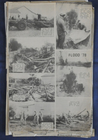
newspaper clippings, June 1978
Orbost has been subject to major floods throughout its history, such as those which left the town isolated in 1934, 1952, 1971 and 1978. It is recorded that the Snowy River broke its banks and flooded the flats 104 times between 1884 and 1978. Extensive flooding in Eastern Victoria during June 1978, caused widespread damage to roads, road closures and hazards to traffic, particularly over the Queen's Birthday holiday weekend. These newspaper articles are contemporary records of a significant event in Orbost history.A collection of black/white newspaper clippings relating to the 1978 flood in Orbost. Some are original articles. others are photo-copies. They appear to be from the Snowy River Mail newspaper.floods-orbost-1978 newspaper-articles -
 Orbost & District Historical Society
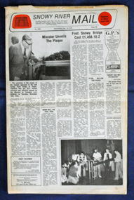
newspaper, Snowy River Mail, 1.12.1976
In early 1974, as an Engineer with the Country Roads Board, David came to Orbost as the Supervising Engineer for the construction of the new bridges which were part of an 8.4km Orbost bypass road design. This was a major project involving not only a new bridge over the Snowy River (including Lochiel Lagoon), but other bridges over Ashby’s Gulch and Watt’s Gulch. These new bridges were opened in November 1976 with the unveiling of a plaque on the eastern end of the $2.4M Snowy River Bridge. The new bridge, built by the CRB at a cost of $2.4 million, is 1.6 metres above the record flood levels of 1971. (ref. May Leatch) This newspaper contains contemporary reports of a significant event in Orbost.A Snowy River Mail newspaper, dated 1.12.1976. It contains news articles, photographs and advertisements. The main article relates to the official opening of the Snowy River Bridge and the unveiling of a plaque on the eastern approach. It also contains a history of the first Snowy River Bridge.snowy-river-bridge orbost-bridges snowy-river-mail -
 Orbost & District Historical Society
magazine, CRB News, August 1976
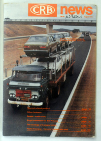
By 1910 it had become apparent that there was a need for a central roads authority to take over responsibility from the Board of Lands and Works for the care and management of the main roads of the state of Victoria. Because there was no consistent and systematic policy for road maintenance Victorian roads were in a deplorable condition. At this time the use of the motor car accentuated the demands for better roads. As a result of these needs the Country Roads Act 1912 was proclaimed in 1913 providing for the establishment of the Country Roads Board as a central road authority with responsibility for those roads within the State considered to be main roads. the C.R.B. was responsible for the construction of roads and bridges including the Snowy River road bridges in Orbost. This was a major project involving not only a new bridge over the Snowy River (including Lochiel Lagoon), but other bridges over Ashby’s Gulch and Watt’s Gulch. These new bridges were opened in November 1976 with the unveiling of a plaque on the eastern end of the $2.4M Snowy River Bridge. (ref. May Leatch) This is a useful reference tool on the history of the construction of the Snowy River road bridges.A journal, titled "CRB News" . On the front cover the title is in orange print with No. 33 August 1976 above a coloured photo of a truck carrying two tiers of new vehicles along a main sealed road. It contains information and photos of the construction of the Snowy River road bridges.on front cover - handwritten in black - "M. I. Gilbert"crb-news country-roads-board snowy-river-road-bridges -
 Marysville & District Historical Society
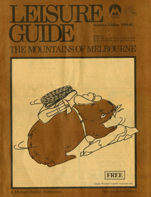
Magazine (Item) - Leisure guide, Michael Cheshire, LEISURE GUIDE THE MOUNTAINS OF MELBOURNE, 1984
A leisure guide to the mountains of Melbourne beginning in the eastern suburbs, going through the Yarra Valley and into the Great Dividing Range. This was produced by Michael Cheshire as a free publication to promote Melbourne tourism. The magazine featured Healesville, Marysville, Warburton, Eildon, Alexandra, the Upper Yarra area, and includes information on wineries in the district. It was released in the summer of 1984-1985.A leisure guide to the mountains of Melbourne beginning in the eastern suburbs, going through the Yarra Valley and into the Great Dividing Range.Summer Edition 1984-85 Featuring:/ Healesville, Marysville, Warburton, Eildon,/ Alexandra, Wineries and Upper Yarra Area.healesville, warburton, eildon, alexandra, upper yarra, marysville, victoria, australia, leisure guide, michael cheshire, blackwood holiday flats, black spur motel and caravan park, tudor lodge road house, nanda binya lodge, marysville caravan park, marysville recreation and fun park, scenic motel, the tower motel, the cumberland, cathedral restaurant, cathedral restaurant gallery, taggerty golf course, taggerty holiday units, marylyn guest house -
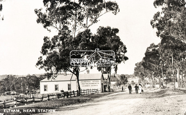 Eltham District Historical Society Inc
Negative - Photograph, Eltham, Main Road near station, c.1910
View looking north along Main Road, Eltham from near present day Dudley Street. On the immediate left is the railway station. The large weatherboard building on the bend (opposite present-day Arthur Street) with signs for General Store, Refreshments and Summer Drinks painted on the side is Luther and Ada Haley’s General Store and Bakery, built 1902. This was the first building in what is now Eltham’s present shopping town centre. Haley previously ran the General Store and Bakery on the corner of Main Road and York Street until his lease expired and the premises were bought by Mrs Sarah Burgoyne in 1902. The store later was known as Staff's Store. Followed by the saleyards, entrance to station, slaughter yard and William J Capewell’s butcher shop. Contained within the saleyards facing the street, a small shelter with the name H.H. Clark upon it. Horace Harold Clark was the son of Eltham State School’s first Head Teacher, David George Clark. As well as being a farmer, he was an Estate Agent and conducted auction sales, presumably from this shelter. On the eastern (right) side of Main Street is Haley’s Paddock, which was used on occasions for community picnics. Capable of holding 10,000 people, with ample shade and hilly surroundings it was an ideal place for any community gathering such as the State Schools’ Picnic in 1904. A worker from the bakery store is standing in the gateway at the rear of the store observing the photographer. People in the ‘Sunday Best’ are milling in front of the bakery or strolling down the centre of Main Road. The picture was most likely taken on a Sunday. With the opening of the railway to Eltham in 1902, Melbourne residents would regularly enjoy a Sunday excursion journey on the train to Eltham for a day’s outing to the countryside or beyond to Hurstbridge from 1912 when the railway was extended. Picture dated as c.1910 based on similar picture published in the Weekly Times, Feb. 1912. Cross Ref: 609 (looking south), 612, 611 (later stage), 613.Negative black and white film 120 6x9 format 2 stripsAgfa APX 100baker, butcher, eltham, eltham railway station, eltham sale yards, eltham slaughter yard, eltham town centre, general store, haley's paddock, hot water, luther haley, luther haley general store, m.m. clark, main road, railway station, shire of eltham pioneers photograph collection, shops, sign, staffs general store, summer drinks, w.j. capewell -
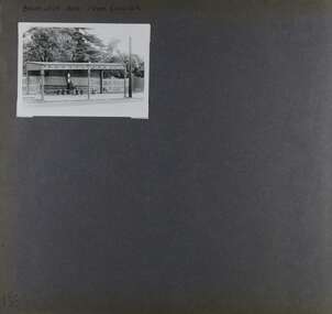 Glen Eira Historical Society
Album - Album page, Balaclava Road Tram Shelter, Circa 1972
This photograph is part of the Caulfield Historical Album 1972. This album was created in approximately 1972 as part of a project by the Caulfield Historical Society to assist in identifying buildings worthy of preservation. The album is related to a Survey the Caulfield Historical Society developed in collaboration with the National Trust of Australia (Victoria) and Caulfield City Council to identify historic buildings within the City of Caulfield that warranted the protection of a National Trust Classification. Principal photographer thought to be Trevor Hart, member of Caulfield Historical Society. Most photographs were taken between 1966-1972 with a small number of photographs being older and from unknown sources. All photographs are black and white except where stated, with 386 photographs over 198 pages. From Victorian Heritage Database citation H0174 TRAM VERANDAH SHELTER CORNER BALACLAVA AND ORRONG ROADS CAULFIELD NORTH - Vic Heritage Register https://vhd.heritagecouncil.vic.gov.au/places/2721 (as at 28/10/2020) The waiting shelter at the corner of Balaclava Road and Orrong Road, Caulfield was constructed in 1916/17 for the Prahran and Malvern Tramways Trust and is one of only three remaining tram shelters in Melbourne designed in the form of a verandah. The shelter has a corrugated iron roof fixed to an angle iron roof frame. The roof, which extends in the form of a skillion over the pavement, is supported on three squared, chamfered timber posts at the rear and three cast iron reeded columns with round bases and Corinthian capitals at the front. (The columns are hollow and function as downpipes, with rainwater discharging from the verandah roof, through the columns and under the ground). The shelter has a rinceau pattern frieze along the road frontage with centrally placed shield motif (which does not contain a coat of arms). The side and rear panels are lined with ripple iron and the upper panel at the rear is lattice work. The shelter has two timber slatted bench seats.From Victorian Heritage Database citation for H0174 TRAM VERANDAH SHELTER CORNER BALACLAVA AND ORRONG ROADS CAULFIELD NORTH - Vic Heritage Register https://vhd.heritagecouncil.vic.gov.au/places/2721 (as at 28/10/2020) How is it significant? The waiting shelter at the corner of Balaclava Road and Orrong Road, Caulfield is of historical and architectural significance to the State of Victoria. Why is it significant? The waiting shelter is of historical significance for its association with the development of the suburban (electric) tram network which assisted the expansion of Melbourne as a suburban metropolis. It is also of historical significance for its connection with the Prahran & Malvern Tramways Trust. The Prahran & Malvern Tramways Trust (1907-1920) was the first municipal electric tramway in Melbourne, becoming the largest and most successful of all the municipal tramway trusts. Its services played a key role in facilitating suburban expansion and the development of the southern and eastern suburbs. The growth of tramways was one of the greatest municipal developments in Victoria during the first decade of the twentieth century. The waiting shelter is an important remnant of this period of Melbourne's transport history and a tangible reminder of the Prahran & Malvern Tramways Trust. The shelter indicates the extent of the Prahran & Malvern tram network. The waiting shelter at corner of Balaclava Road and Orrong Road, Caulfield is one of only three remaining tram shelters in Melbourne designed in the form of a verandah. The waiting shelter is of architectural significance for the distinctive design and construction which is unique to the Prahran & Malvern Tramway Trust tram network. The shelter was designed by notable Melbourne architect Leonard J. Flannagan (1864-1946). Flannagan was responsible for a number of buildings for the Prahran and Malvern Tramways Trust including the early waiting shelter at the junction of Dandenong Road and Hawthorn Road, Caulfield, and sections of the tram depot at Malvern, and also designed a depot for the Hawthorn Tramways Trust. The waiting shelter, a conservative design influenced by Victorian architecture, is based on the Melbourne City Council late 19th century standard cast iron verandah. It is of significance as an intact example of the cast iron type shelter and for its detail, including Corinthian columns and a 'rinceau' pattern cast-iron frieze. The shelter is largely in keeping with the original design and retains its integrity. The cast iron waiting shelter is also of significance as an unusual example of early twentieth century street architecture. Page 155 of Photograph Album with one landscape photograph of a tram shelter on Balaclava Road.Handwritten: BALACLAVA ROAD TRAM SHELTER [top] / 155 [bottom left]trevor hart, verandah, garden, grimwade house, grimwade, orrong road, balaclava road, melbourne grammar, melbourne grammar junior school, mgs, m.g.s, school, tram shelter, waiting shelter, prahran & malvern tramway trust, leonard j. flannagan, cast iron verandah, cast iron type shelter, corinthian columns, 'rinceau' pattern cast-iron frieze, rinceau, cast iron frieze, victorian style, caulfield north, leonard flanagan, cast iron work, prahran and malvern tramways trust, trams -
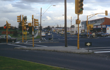 Glen Eira Historical Society
Album - Page 8 of folder D-F, Caulfield Municipality Photo Slide Collection, c.1976 - c.1994
The photographs for the slides are believed to have been taken by the inaugural Editor for the Caulfield Contact - the official newspaper of the former City of Caulfield from 1976-1994. The Editor was also Council's Community Liaison Officer and she (and her successor) took many photographs of official events and Council-related services and locations in connection with both these official roles. The City of Caulfield was the Municipal Council for an area of the South Eastern suburbs of Melbourne, including Brighton East, Carnegie, Caulfield, Elsternwick, Gardenvale, Glen Huntly, McKinnon, Murrumbeena, Ormond and St Kilda East. Credit: Glen Eira Historical Society - This item was digitised and made available through the Glen Eira Heritage Digitisation Strategy 2019-2023. Glen Eira Historical Society acknowledges the support of Glen Eira City Council. Page 8 of slide album D to F, in a polypropylene slide sleeve containing 20 x 35mm colour slides. A sample of 7 images from this page is included. glen eira city council, local government, caulfield city council, caulfield council, city of caulfield, caulfield contact, council services, brighton east, carnegie, caulfield, elsternwick, gardenvale, glen huntly, mckinnon, murrumbeena, ormond, st kilda east, caulfield municipality photo slide collection, roads and streets, north road, murrumbeena road, neerim road, queens avenue, sports and recreations, tennis, petrol stations, alma road, orrong crescent, caulfield north, east boundary road -
 Glen Eira Historical Society
Document - CUMBERNAULD
This file contains nine pages about people related to this property: 1/Copy and pasted eight pages taken from Census Records and Trove items. Articles include the death of Thomas Livingstone Cleland during WWI. Various social notes regarding his family up to 1953. There are articles on the W.J. Mathieson family, who also resided there, as well as residing in Benalla. 2/Print from Trove of an article from the 23/11/1934 edition of The North Eastern Ensign (Benalla, Vic) about the wedding anniversary of Mr and Mrs W.J. Mathieson, held at Cumbernauld on 27/10/1934.cumbernauld, thornleigh grange, house names, cleland thomas livingstone, cleland annie, gardeners market, clayton road, ‘hillside’, caulfield, anderson street, cleland sydney, cleland margaret, cleland james, cleland adelaide, cleland robert, cleland bessie adelaide, cleland agnes, cleland lily, cleland alick douglas milkman, cleland aggie, cleland tom h.s. draftsman, cleland kenneth malcolm, cleland ethel, cleland hector, cleland edna may, mathieson w.j., mathieson isabel, burrows f.a. lieut., east st. kilda, hawthorn road, ‘thornleigh grange’, south caulfield progress association, south caulfield junction, caulfield court, jenkins harry, giles alfred, grafton street, elsternwick, dawes john, chloris crescent, st. john’s presbyterian church, mathieson evelyn mary, marks theodore leslie, mathieson kitty, masonic hall, st. george’s road, haverfield frank, haverfield mrs, haverfield robert ross, rynn mary buckley, cyclists, cycling, donald alexander, martin lottie, whitelaw joan, trinity hall, brighton road, gilmore patricia phyllis, brooklyn ave., point nepean road, north road, brighton court, cleland nora, seaview drive, cleland john stuart, mathieson isabella cristina, kalymna grove, mathieson catherine m., tailor, mathieson william james, councillors, social events and activities, births deaths and marriages, anniversaries, world war 1914-18, soldiers -
Glen Eira Historical Society
Document - GLEN HUNTLY (HISTORY OF)
This file contains one item: 1/A loose-leaf, 23-page document titled ‘The History of Glen Huntly’, by Alfred R. Jones, dated 20/06/1991, describing the history of the suburb. The author has drawn heavily from the 4 sources noted in the bibliography. Subjects covered include the ship the suburb is named after, the suburb’s State School, the suburb’s churches, the Rosstown Railway and Sugar Mill, the origin of the name of Carnegie, the suburb’s aerodrome, and the beautification of the Glen Huntly Shopping Centre. The final 12 pages consist of 9 appendices relating to the aforementioned subjects. Appendix A is a typewritten letter from Ron McLeod, secretary of the Place Names Committee, to Mr. D. R. Aylen, CEO of the City of Caulfield, notifying the latter of the alteration of the name ‘Glenhuntly’ to ‘Glen Huntly’. Appendix B is a list of the ministers of St. David’s Uniting Church from its formation in 1916 to the present. Appendix C identifies the persons portrayed in St. David’s stained glass windows. Appendix D is a poster announcing the auction of 41 blocks of land between Hawthorn and Bambra Road formerly owned by William Ross, plus a map identifying said land blocks and anither fir locality. Appendix E is an A4 plan of the Rosstown Railway. Appendix F is a drawing of the Rosstown Sugar Mill. Appendix G is a poem titled ‘The Swagman’s Retreat’, by Herb Arnott, about the failure of the Mill. Appendix H is a map of Caulfield’s horse tramways plus a list of opening and closing dates. Appendix J is a list of streets explaining the meanings of their names.glen huntly, glenhuntly, local history, ‘glen huntly’ (ship), ‘glen huntlely’ (ship), quarantine stations, glen huntly road, lake street, mernda avenue, glen huntly state school no. 3703, ormond francis, ormond, garden avenue, grange road, churches, congregational church, glen huntly presbyterian church, st. david’s, st. david’s uniting church, anglican church, jenkin william ‘boss’, methodist church, wattle avenue, smith a. w. mr., glen huntly post office, glen huntly road, king f. l. mr., uniting church, child care centre, presbyterian church of eastern australia, glen huntly methodist church, sun aria, miller mary, stained glass, phrenologists, trinity congregational church, primitive methodists, ‘the victorian independent’, mercy mr., greek orthodox original old calendar church, wanalta road, salvation army, halls, myrtle street, catholic church, st. anthony’s roman catholic church, foundation stones, neerim road, mannix archbishop, st. agnes’ anglican church, booran road, sunday schools, clergy residences, ‘see’ anglican news magazine, lees archbishop, booth archbishop, glen huntly presbyterian church, el nido grove, tennis courts, bollard v. w. right rev., waratah avenue, royal avenue, munster avenue, james street, rothschild street, peace memorial organ, singers, bremner marie, scotland betty, carden joan, rosstown railway, south caulfield, plants, marata road, curraweena road, bambra road, ross william murray, ross leila, ross constance, vautin constance, ‘the grange’, north road, leila road, wild cherry road, caulfield roads board, elsternwick, land sales, sugar mills, koornang road, woornack road, elsternwick railway station, riddell parade, clarence street, dover street, oakleigh road, murrumbeena crescent, carlisle crescent, railways, trains, parks and reserves, caulfield council, sussex street, caulfield city council, swamps, rosstown sugar mill, rosstown estate, ‘the swagman’s retreat’, arnott herb, rosstown, carnegie, ‘ross’s folly’, carnegie andrew, rosstown hotel, dandenong road, rosstown road, rosstown plate horse race, caulfield racecourses, ames avenue, rosstown court, hostels, murrumbeena, cinemas, innovations (cabinetry film), films, music, pianos, manchester grove, safeway store, squash courts, airports, lord reserve, aeroplanes, air navigation act 1921, neville street, larkin sopwith aviation company of australasia, lyons street, morgan street, bookmakers, nightsoil, poultry, weatherboard buildings, glen huntly railway station, rosedale avenue, rifle clubs, scout groups, 1st glen huntly troop, ana, dowding jack mr., glen huntly infant welfare and family planning clinic, vermador private hospital, watson grove, rowlands (drapers), bones plant nursery, caulfield railway station, bridges, trams, horse tramways, glen eira road, elsternwick railway station, kooyong road, aboriginal peoples, truganini road, hannan lyn mrs. (urban planning officer), glen huntly shopping centre, sculptures, street beautification scheme, “flying the yellow flag”, moore olive, “return to rosstown”, jowett d. f., weickhardt i. s., “from sand swamp and health”, murray peter r., wells john c., caulfield historical society, newsletters, place names committee, mcleod ron, aylen d. r. mr., jones hugh rev., king joseph, scarfe james, vertigan sidney, vertigan earle, rance victor, flavell cameron, denholm robin, moorhead ken, taliai siupeli, eccles james leslie, little agnes, hutchins william r., dickie may a., gordon ivey agnes, theobald a. a. mrs., brownbill lloyd norman, ash georgette, land sales, auctions, messrs. crews & arkle, street names -
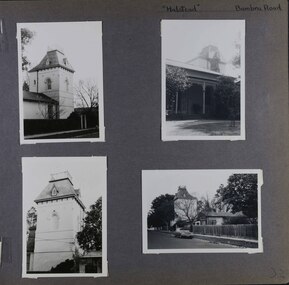 Glen Eira Historical Society
Album - Album page, Halstead, Bambra Road, Circa 1972
This photograph is part of the Caulfield Historical Album 1972. This album was created in approximately 1972 as part of a project by the Caulfield Historical Society to assist in identifying buildings worthy of preservation. The album is related to a Survey the Caulfield Historical Society developed in collaboration with the National Trust of Australia (Victoria) and Caulfield City Council to identify historic buildings within the City of Caulfield that warranted the protection of a National Trust Classification. Principal photographer thought to be Trevor Hart, member of Caulfield Historical Society. Most photographs were taken between 1966-1972 with a small number of photographs being older and from unknown sources. All photographs are black and white except where stated, with 386 photographs over 198 pages.From the Victorian Heritage Register Database - Citation for Halstead, 23 Bambra Road as at (as at 12/10/2020) https://vhd.heritagecouncil.vic.gov.au/places/276 Halstead is believed to be the oldest standing residence in Caulfield constructed in 1857 with subsequent additions during the 19th Century. The house was built for and owned by James Dickson, a stock agent, until his death in 1880. Although on a much reduced parcel of land, Halstead is one of the few remaining remnants of Caulfield when it was an area of mansion houses occupied by town residing squatters, professional and business men. It is important for its place in the socio-economic history of south eastern suburban Melbourne, the inland pattern of development stretching from Malvern through Murrumbeena. Architecturally the single storey building displays a history of alteration and addition. Its main front presents with a single storey cast iron verandah across the full width, including the two pavilion wings at each end. Located towards the rear on the Halstead Street side is the substantial three storey tower with its Mansard roof and cast-iron balustrade which makes the house clearly visible from Halstead Street and Bambra Road. Because of internal alteration the importance of the building relates to the exterior only of the main house. Halstead is believed to be the oldest standing residence in the city of Caulfield. https://vhd.heritagecouncil.vic.gov.au/places/43645 "Halstead" is regionally important as a surviving large villa from the early Victorian (1850's) period, offering insights into the lifestyles of the privileged in Caulfield at that time. The later tower is of architectural interest for its use of Medieval Romanesque enrichment.Page 32 of Photograph Album with four photographs of the exterior of this double storey house, focussing on different angles for the house's tower.Hand written: "Halstead" Bambra Road [top right] / 32 [bottom right] trevor hart, caulfield north, bambra road, 1850's, halstead, james dickson, mansion, villa residence, cast iron verandah, pavillion wings, halstead street, victorian, tower, balustrading, decorative brackets, mansard roof, brick, cast iron, slate roof, curved windows, single storey mansions, streetscapes, medieval romanesque style, slate roofs, gardens, cast iron work -
 Glen Eira Historical Society
Album - Album page, Halstead, Bambra Road, Circa 1972
This photograph is part of the Caulfield Historical Album 1972. This album was created in approximately 1972 as part of a project by the Caulfield Historical Society to assist in identifying buildings worthy of preservation. The album is related to a Survey the Caulfield Historical Society developed in collaboration with the National Trust of Australia (Victoria) and Caulfield City Council to identify historic buildings within the City of Caulfield that warranted the protection of a National Trust Classification. Principal photographer thought to be Trevor Hart, member of Caulfield Historical Society. Most photographs were taken between 1966-1972 with a small number of photographs being older and from unknown sources. All photographs are black and white except where stated, with 386 photographs over 198 pages.From the Victorian Heritage Register Database - Citation for Halstead, 23 Bambra Road as at (as at 12/10/2020) https://vhd.heritagecouncil.vic.gov.au/places/276: Halstead is believed to be the oldest standing residence in Caulfield constructed in 1857 with subsequent additions during the 19th Century. The house was built for and owned by James Dickson, a stock agent, until his death in 1880. Although on a much reduced parcel of land, Halstead is one of the few remaining remnants of Caulfield when it was an area of mansion houses occupied by town residing squatters, professional and business men. It is important for its place in the socio-economic history of south eastern suburban Melbourne, the inland pattern of development stretching from Malvern through Murrumbeena. Architecturally the single storey building displays a history of alteration and addition. Its main front presents with a single storey cast iron verandah across the full width, including the two pavilion wings at each end. Located towards the rear on the Halstead Street side is the substantial three storey tower with its Mansard roof and cast-iron balustrade which makes the house clearly visible from Halstead Street and Bambra Road. Because of internal alteration the importance of the building relates to the exterior only of the main house. Halstead is believed to be the oldest standing residence in the city of Caulfield. https://vhd.heritagecouncil.vic.gov.au/places/43645: "Halstead" is regionally important as a surviving large villa from the early Victorian (1850's) period, offering insights into the lifestyles of the privileged in Caulfield at that time. The later tower is of architectural interest for its use of Medieval Romanesque enrichment.Page 33 of Photograph Album with one landscape photograph of the exterior of Halstead, taken from the street.Hand written: 33 [bottom left] trevor hart, caulfield north, bambra road, 1850's, halstead, james dickson, mansion, villa residence, cast iron verandah, pavillion wings, halstead street, victorian, tower, balustrading, decorative brackets, mansard roof, brick, slate roof, curved windows, single storey mansions, cast iron work, medieval romanesque style, slate roofs, gardens -
 Federation University Historical Collection
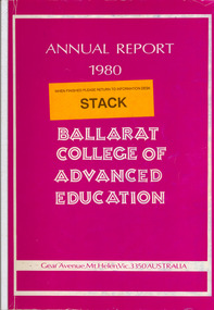
Book, Ballarat College of Advanced Education Annual Report, 1980
In 1980 M.B.John was Council President. In 1980 the School of Arts moved into their new building, 1870 Founders Hall was financed - at a cost of $800,000 - from the proceeds of the SMB Centenary Appeal, and was completed late in 1980. Extensive work was carried out on the Student Residences and the former Education Department Hostel in Victorian Street. The amphitheatre adjacent to the eastern side of the Education Buildings was constructed, together with the nearby disabled ramp. Negotiations with the Shire of Buninyong were continued for access to the campus from the Green Hill Road. Following the creation by Act of Parliament in 1978 of the Victorian Post-Secondary Education Commission (VPSEC) amendments to the same Act early in 1980 made provision for the repeal of the VIC and SCV Acts. From mid-December 1980 these latter two bodies ceased to exist when the provisions for repeal of their Acts were proclaimed. The Victorian Institute of Colleges had been set up in 1965 to aid in the co-ordination and development of a number of non-university tertiary institutions that affiliated with it from 1965 on to become Colleges of Advanced Education. In taking up this role which had been spelt out in 1964 by the martin Committee, the VIC broke new ground in a whole range of operations. It became responsible for the physical development of new building programmes and new campuses from many of its colleges, for the procurement of operating funds from the Commonwealth, for the accreditation of new courses of study, for the first non-university degrees to be awarded in Australia and so on. The Former Ballarat Institute of Advanced Education (the tertiary division of the School of Mines) was affiliated with the VIC from the outset and its progress towards a new status, rapid growth and vastly improved physical resources was closely linked to and dependent upon the efforts of the VIC. The similar co-ordinating authority - The State College of Victoria - was established in 1973 to similarly foster the autonomous development of the former teachers colleges. its early work was highly influential in the transition of the Ballarat Teachers' College into the State College of Victoria at Ballarat. On the merging of the BIAE and the SCVB in 1976, the new college continued under the co-ordination of the Victorian Institute of Colleges. The major contribution made to the progress and stature of became the Ballarat College of advanced Education by both the VIC and SCV, and their Councils and officers, over the formative years of rapid change and evolution is acknowledged and recorded with appreciation. Such efforts by the two central authorities have markedly assisted in bringing the College to the present point where its accumulated experiences and traditions provide a sound basis on which it can confidently and responsibly exercise the greater autonomy gradually passing it. Purple soft covered book of 47 pages. Contents include: development of a Nurse education course, College organisational Structure, Role of Head of School, resignation of Norman Baggaley, appointment of R. Macgowan, opening of Business Resource Centre, Librarianship, resignation of M.J. Sandow-Quirk, E.A. Widdop, J. Leeuwenburg, Thelma Rungkat, Erica Myers, former Acting Head of School John Mildren elected to the Federal seat of Ballarat, Ray Watson, Resignation of A.C. Burrow, return of W.J. Vermeend, P.L. McCarthy, P.R. Calder, J.A. Fulcher, L.E. Taylor, L.J. McGrath, Teaching Resource Centreballarat college of advanced education, bcae, mt helen, mount helen, sandow-quirk, widdop, leeuwenburg, rungkat, myers, burrow, vermeend, mccarthy, calder, fulcher, taylor, victoria street -
 Federation University Historical Collection
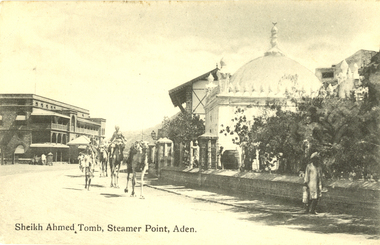
Postcard - black and white, Sheikh Ahmed Tomb, Steamer Point, Aden, c1914
Aden is a seaport city in Yemen, located by the eastern approach to the Red Sea (the Gulf of Aden), some 170 kilometres east of Bab-el-Mandeb. Aden was the capital of the People's Democratic Republic of Yemen until that country's unification with the Yemen Arab Republic. On that occasion, the city was declared a free trade zone.[citation needed] Aden gives its name to the Gulf of Aden. (Wikipedia)Black and white postcard showing Sheikh Ahmed's Tomb at Steamer Point, Aden. A number of camels are walking down the road. chatham-holmes family collection, aden, sheikh ahmed tomb, postcard, hotel de l'europe