Showing 969 items
matching homestead
-
 Linton and District Historical Society Inc
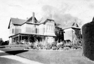
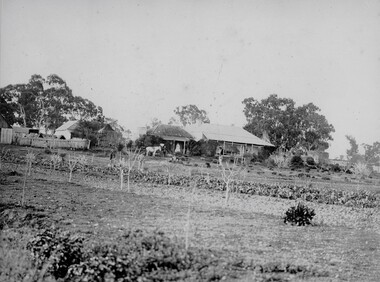
Photograph, Langi Willi Homestead, Pittong, circa 1911
Langi Willi pastoral station was one of several grazing properties owned by the Russell family of Carngham. After the death of Philip Russell, the property was inherited by his son George Russell.Small sepia photograph of large two-storey residence.On back: "Langi Willi / Pittong"langi willi homestead, buildings, houses, russell family -
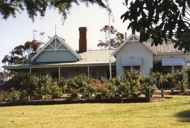
 Ringwood and District Historical Society
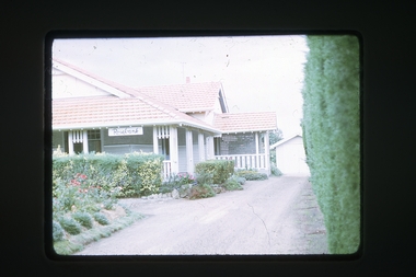
Photograph, Rosebank homestead at 149-151 Warrandyte Rd, Ringwood North, circa 1960s
-
 Darebin Art Collection
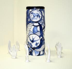
Sculpture, Vipoo Srivilasa, Bundoora Homestead, 2006
bundoora homestead -
 Darebin Art Collection
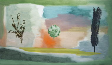
Painting, John Sheehan, Portrait of Three Trees (Outside Bundoora Homestead), 2010
-
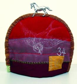 Darebin Art Collection
Textile, Tara Badcock, Teacosy Number 34, Bundoora Homestead, 2007
bundoora homestead -
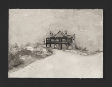 Darebin Art Collection
Drawing, Paul Compton, Homestead on a Hill, 2010
-
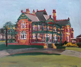 Darebin Art Collection
Painting, Stephen Armstrong, Bundoora Homestead I, 2007
bundoora homestead, queen anne style, federation -
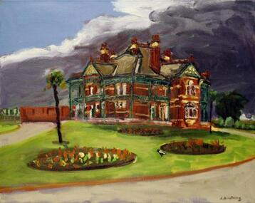 Darebin Art Collection
Painting, Stephen Armstrong, Bundoora Homestead II, 2007
bundoora homestead, queen anne style, federation -
 Buninyong & District Historical Society
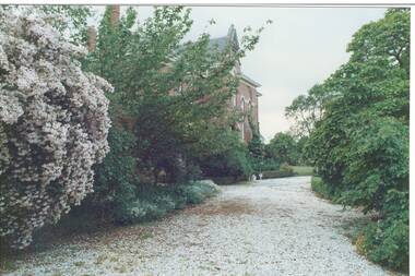
Photograph - Part of gravel path and garden of Buninyong Homestead and gardens in November 1991, View showing part of the gardens of Mount Buninyong Homestead taken by Ann Beggs-Sunter on 21/08/1997
Former rural landscape being alteredGood condition, but slightly fadedNoneerection of steel framed building on former rural landscape., photograph taken on 26/05/1968. -
 Buninyong & District Historical Society
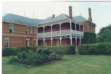
Photograph - Rear of Buninyong Homestead and gardens on November 1991, View showing the rear of Mount Buninyong Homestead taken by Ann Beggs-Sunter on 21/08/1997
Former rural landscape being alteredGood conditionNoneerection of steel framed building on former rural landscape., photograph taken on 26/05/1968. -
 Darebin Art Collection
Painting, Sharon West, Bundoora Homestead Welcome, 2003
bundoora homestead -
 Darebin Art Collection
Print, Sharon West, The Frilled-neck Filly of Bundoora Homestead, 2011
bundoora homestead -
![Work on paper, Ju-Yuen Merran Chew, Living History [Bundoora Homestead], 2007](/media/collectors/5f20fa7a21ea670b2cb4258e/items/60bdb91a6c312a58ab6c7a24/item-media/60bdb9626c312a58ab6c7eae/item-fit-380x285.jpg) Darebin Art Collection
Darebin Art CollectionWork on paper, Ju-Yuen Merran Chew, Living History [Bundoora Homestead], 2007
-
 Whitehorse Historical Society Inc.
Article, Have your say in Strathdon House, 2015
Whitehorse Council is inviting community feedback.Whitehorse Council is inviting community feedback on the draft report for conservation of the Strathdon Homestead and orchard in Springvale Road, Forest Hill.Whitehorse Council is inviting community feedback. strathdon homestead, springvale road, forest hill, city of whitehorse -
 Phillip Island and District Historical Society Inc.
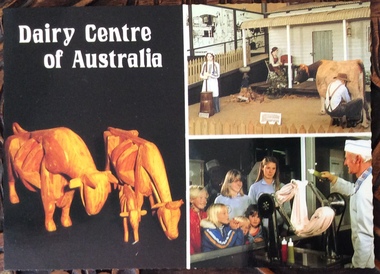
Postcard, Scancolor Australia et al, Dairy Centre and Rhylstone Park, Phillip Island, C. 1980s
Two coloured postcards. One of displays at the Dairy Centre, Newhaven. The second of Rhylston Park homestead, Cowes and it’s display of antiques and clocks.Dairy Museum, Phillip Island Road, Newhaven. Victoria 3925. Phone (059)567583 All Hours Rhylston Park Homestead Thompson Ave Cowes 3922 Phone (059)59522856. Rhylston Park(1886) features a display of over 380 antique clocks and watches. This unique collection is enhanced by the original homestead with beautiful lead light, ornate metal ceilings and marble fireplaces.the dairy centre, newhaven, homes, postcards -
 Mt Dandenong & District Historical Society Inc.
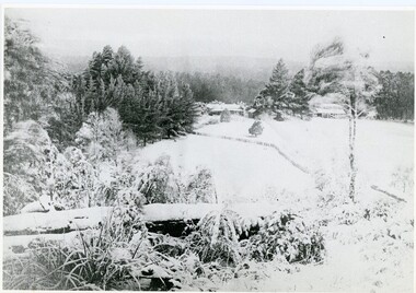
Photograph, A View Over Mountain Grange 1921, 1921
A view of Mountain Grange Homestead built by Thomas Hand with buildings and ground covered in snow. The photograph has historical information on the back handwritten by John Lundy-Clarke in 1976.1921 A view over “Mountain Grange” from the side of Mt Kalorama above where Grange Road is now. On the left of the homestead is the avenue of pine trees under which the annual Sunday School picnic was held. On the right is the giant pine that still stands (1976) and the great barn. The separate kitchen of the homestead can be clearly seen. mountain grange, snow, john lundy-clarke, thomas hand -
 Sunbury Family History and Heritage Society Inc.
Postcard, John Sands Pty. Ltd, Emu Bottom
The homestead featured on the postcard is 'Emu Bottom', which is claimed to be Victoria's oldest homestead, although over the years sections of the homestead have had to be rebuilt as result of fires so little of the original materials remain in the building. The homestead was built by George Evans in the 1830s when he squatted on a tract of land in the Jacksons Creek valley in Sunbury. A non-digital coloured photograph in post card format of a single storey homestead with a timber shingle roof. A timber post and rail fence is across the front of the property. The post card has a crinkled edge.'emu bottom', george evans, homesteads, jacksons creek, sunbury -
 Bendigo Historical Society Inc.
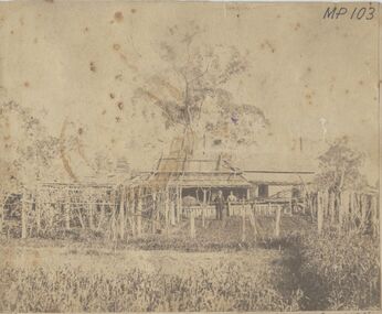
Photograph - HOMESTEAD, BENALLA, 1876, 1876
sepia photo: homestead, shingle roofed with couple standing in front. Garden and trellacing in foregound. On front MP 103/41 Mr. Jonathan Harris, Senr. And Mary his wife, his residence, Benalla, Victoria, Year 1876.buildings, residential, homestead -
 Lakes Entrance Historical Society
Photograph - Nyerimilang, 1999
Nyerimilang Homestead is in public ownership, managed by Parks Victoria.Colour photograph of Nyerimilang Homestead showing front view, including rose garden. Situated off Kalimna West Road, Nungurner, it is a large white painted timber homestead, corrugated iron roof of hips and gables, painted green, five internal brick chimneys. Situated above the lake with views of Fraser Island and Flannagan Island, outer barrier and distant ocean. Nungurner Victoriahistoric buildings, local history -
 Stawell Historical Society Inc
Photograph, "Allanvale" Home Station in Great Western 1866
Allanvale Home Station. Part of a collection of Photographs by Mr. O.G. Armstrong as commissioned by the Shire of Stawell for the Inter-colonial and Paris Exhibition in Melbourne in 1866. Allanvale was taken up about 1841 by John Allen, who was the son of George Allan of Allanvale, near Launceston in Van Diemen's Land. He selected 80,000 acres between present day Stawell and Ararat. The property was gradually reduced in size, with the first split occurring in the 1840s with the annexation of Concongella Selection due to a land dispute. J.S. Davidson was the occupier of Allanvale at the time this photograph was taken. The homestead pictured here was destroyed by fire at the end of the First World War and replaced by a new building around 1923. The present owners of Allanvale are the Kilpatrick family A note on the Allan family. On the 15th of March 1845, John Allen's 26 year old wife died at the birth of their third child, a daughter, who also died several weeks later. Elizabeth Allen had been a dear friend of Mrs Horatio Wills of neighbouring Lexington station. Eliza and her daughter were buried side by side in the garden of Lexington homestead. She was said to have been the first white woman to have died in the district. Homestead and stables on left with people on verandah and orchard in foreground.stawell great western -
 Phillip Island and District Historical Society Inc.
Photograph, 1978/9
The Homestead was probably built about 1872 when Samuel Amess became the owner of Churchill Island. A large weatherboard construction with bay windows and corrugated iron roofing.Coloured photograph showing the homestead on Churchill Island. Bay windowed rooms projecting forward on either side of the verandah. Not the sundial in the foreground.local history, photographs, buildings - historical, rural industry, coloured photograph, john cook, churchill island -
Lakes Entrance Historical Society
Photograph - Strathfieldsaye Homestead, 1/12/1987 12:00:00 AM
Also another colour photographs taken at same time of Strathfieldsaye Homestead 05049.1 10 x 15 cmColour photograph showing the front verandah wisteria vine and garden at Strathfieldsaye Homestead taken up by William O'Dell Raymond in 1942 on Lake Wellington Gippsland Victoriaagriculture, houses -
 Old Gippstown
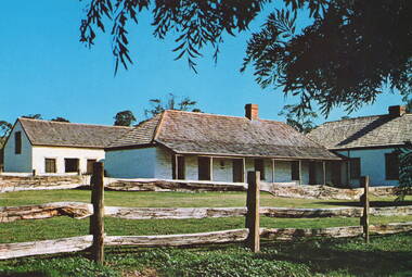
Building - Bushy Park
13 August 1843 First application for the Bushy Park run appeared in the “Port Phillip Gazette”. It was taken up by Angus McMillan, who took up the Boisdale run across the Avon River at the same time, for his employer Lachlan Macalister. This house was built in 1848. March 1844 Licence to Bushy Park granted to McMillan. It consisted of 16,000 acres. Late 1840s Bushy Park homestead built for McMillan by Andrew Martin and Matt McCraw. High local historic significance as associated with major pioneer and a very old white settlement in Gippsland.A square shaped timber house, with a corrugated iron roof over shingles. It has a verandah that covers both the front and sides of the house. The house is contructed of redgum timber, and internally has four rooms.National Trust of Australia Plaque - Bushy Park Homestead - Class 'C'mcmillan, angus, old gippstown, west gippsland, gippsland, gippsland heritage park, goldfields, victorian era, moe, historical village, wellington shire, avon river, boisedale, briagolong, dargo, murdoch mackintosh, national trust, andrew martin and matt mccraw., latrobe valley, old gippstown heritage park, gunaikurnai, latrobe city council -
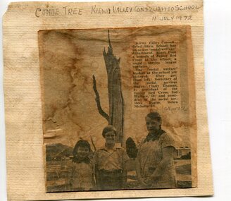 Kiewa Valley Historical Society
Newspaper clipping 11/7/72 Canoe tree in Kiewa & Photo-Tawonga Homestead
1. Kiewa Valley Consolidated School was established in 1953 combining Dederang North, Kergunyah, Gundowring, Kiewa, Gundowring Upper, Red Bluff, Charleroi and Gundowing North schools on a 10 acre site with 11 rooms at Kiewa. The bark was cut from the canoe tree, by aboriginal craftsmen, to produce a canoe for fishing in the rivers running through the Kiewa Valley either before or just after the 1800's. The tree trunk, located at Kiewa, would have been used at the beginning of European settlement in the Kiewa Valley or just before contact was made. 2. Pictorial record of the graves of early pioneers C Ibbotson, Mrs Elizabeth Eyre and John Eyre who died between 1858 – 1904, all located at Tawonga Homestead 1. The above schools are in the Kiewa Valley. The date and number of combined schools give insight into the change in population and families in the Kiewa Valley before and after 1953. The tree was found along the Kiewa River and indicates that Aborigines lived by the river and used tree bark to craft canoes to cross rivers and to fish in the deeper sections of the river. 2. Pictorial record of the early history of Kiewa Valley pioneers whose descendants have lived and worked in the Kiewa Valley for many years 1. Newspaper article of local school children visiting a canoe tree in Kiewa July 11, 1972. mounted on buff card 2. Black and white photo of pioneer graves at old Tawonga Homestead. Mounted on buff card 1. Handwritten in black ink above newspaper clipping ‘Canoe Tree Kiewa Valley Consolidated School. 11 July, 1972’ Handwritten in pencil at bottom of article ’10 Nov. ‘72’ 2. Handwritten in black ink above photo ‘Tawonga Homestead graves’ Handwritten below photo ‘T Ibbotson D. 1858, Elizabeth Eyre D. 1879, John Eyre D 1879, John Eyre D. 1904 tawonga homestead, canoe tree at kiewa, tawonga graves -
 Phillip Island and District Historical Society Inc.
Photograph
This homestead was situated next to the Lagoon Ventnor. The McHaffie brothers leased the Island from 1842 to 1863. Sepia photograph believed to be the McHaffie Homestead, Ventnor, Phillip Island. NB by C Grayden 6/7/2015. The envelope that these photos were stored in has a typed note "Cumloden", St. Kilda.phillip island, mchaffie homestead, mchaffie brothers -
 Port Fairy Historical Society Museum and Archives
Photograph, Leura
Leura homestead owned by Dick and Mary Fry. They appear on the verandah in this photoSepia Photographhomestead, building, home, house, leura -
Whitehorse Historical Society Inc.
Document, Archaeology Assessment, 1/11/2002 12:00:00 AM
City of Whitehorse archaeology assessment citing 4 properties identified.City of Whitehorse archaeology assessment citing 4 properties identified: The Burwood Uniting Church, Burwood East; The Wattles, Vermont South; Strathdon Homestead; Montana, Mitcham. Prepared by Biosis Research Pty. LtdCity of Whitehorse archaeology assessment citing 4 properties identified. city of whitehorse, uniting church, burwood east, wattles, vermont south, strathdon homestead, montana, mitcham -
 Bendigo Historical Society Inc.
Photograph - RAVENSWOOD HOMESTEAD
Black and white image : Ravenswood Homestead, Ravenswood, south of Bendigo. Image shows two storey brick building, verandah surrounding, single storey section with curved inserts in brickwork, on RH side.house, heritage, ravenswood, ravenswood, pastoral, farming, homestead -
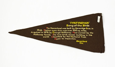 National Wool Museum
Pennant
TYNTYNDYER HOMESTEAD TYNTYNDYERtyntynder homestead, beverford, victoria -
Pyrenees Shire Council
painting, The Firs, Raglan Road, Beaufort by Sue Jarvis, 1993
significant as a work of art by local Pyrenees artist, locally significant to the Central Highlands Region of Victoria as a representation of local landscape and/or culture painting of homestead"Signed: JARVIS Verso: THE FIRS, RAGLAN ROAD, BEAUFORT SUE JARVIS 1993 55 BRANTOME ST GISBORNE 3437 PH 054282674 OR BLACKWOOD LANE STUDIO 24 BLACKWOOD LANE GENBROOKN3738 PH 059 681 567 $525"