Showing 560 items
matching land sales.
-
 Bendigo Historical Society Inc.
Map - PARISH OF SANDHURST 1961, 1961
... Land sales...BHS Collection BENDIGO Land sales parish map Dept of Lands ...BHS CollectionAt Bendigo Parish of Sandhurst. Sheet 13Dept of Lands and Surveybendigo, land sales, parish map -
 Bacchus Marsh & District Historical Society
Map, Plan of the second portion of the property of Messers Atkins and Clarke situate at Bacchus Marsh 1856
... Land Sales... for sale. This is a very early land sales plan for agricultural ...This plan of land allotments for sale indicates part of the property once owned by the Bacchus family in and around the township area of Bacchus Marsh. The Bacchus family sold their property in Bacchus Marsh to John Aitkins and Robert Nalder Clarke in March 1851. Aitkins and Clarke kept the property for a number of years until April 1856 when these allotments were put up for sale.This is a very early land sales plan for agricultural land close to the township of Bacchus Marsh. It therefore provides some clues as to how the early urban development of the township and agricultural development of the nearby area took place. Upon seeing the map in 1911 Bacchus Marsh Express newspaper editor Christopher Crisp wrote "The sale appears to have created the present township, which had a nucleus in earlier times further east", Express, 30 September, 1911, page 3.A single page paper plan showing allotments of land for sale. The subdivided land shown was owned by John Aitkins and Robert Nalder Clarke, but previously owned by the Bacchus Family and was in and around their Manor House (Mansion) property in Bacchus Marsh. This plan shows allotments in the second portion of land to be sold which was located east of the Manor House on the eastern side of the Lerderderg River. The land for sale was made up of 15 allotments. The plan is pasted into a bound volume containing 76 maps or plans in total. BMDHS Loc: AR/B12/S4 Bacchus Marsh Township and Nearby Districts Maps Volume In-house Digital copies: BMDHS, Computer Network: Maps\Bacchus Marsh Township and Nearby Districts Maps Volumebacchus marsh victoria maps, bacchus family, land sales, manor house bacchus marsh -
 Bacchus Marsh & District Historical Society
Map, Plan of the property of Messers Atkins and Clarke to be sold at the Mansion, Bacchus Marsh 19th April 1856. Copy 1
... Land Sales... points. This is a very early land sales plan for the township ...This plan of land allotments for sale indicates the property once owned by the Bacchus family in and around the township area of Bacchus Marsh. The Bacchus family sold their property in Bacchus Marsh to John Atkins and Robert Nalder Clarke in March 1851. Atkins and Clarke kept the property for a number of years until April 1856 when these allotments were put up for sale.This plan is almost identical to another copy held by the Bacchus Marsh and District Historical Society, VC Record 452, BMDHS collection). This plan, VC Record 707 Copy 1, contains a little more detail overall than VC Record 452 Copy 2, such as who did the survey work for the plan (R.C. Bagot) and who the selling agents were, (W.M. Tennent), and on the right side of the plan near the Lerderderg River is indicated the general area for a second parcel of land from this sale which is to be sold. There is also a compass illustration indicating north and south compass points.This is a very early land sales plan for the township of Bacchus Marsh and it therefore provides some clues as to how the early urban development of the township took place. Upon seeing the map in 1911 Bacchus Marsh Express newspaper editor Christopher Crisp wrote "The sale appears to have created the present township, which had a nucleus in earlier times further east", Express, 30 September, 1911, page 3.A single page paper plan showing allotments of land for sale. The subdivided land shown was owned by John Atkins and Robert Nalder Clarke, but previously owned by the Bacchus Family and was in and around their Manor House (Mansion) property in Bacchus Marsh.There are 5 portions of land further divided into numerous small portions. The land for sale is bounded by the present day streets of Main Street, Young Street, McFarland Street, Morton Streets, Crook Street, and part of the eastern section extends to the Lerderderg River. Scale: 8 chains to 1 inch The plan is pasted into a bound volume containing 76 maps or plans in total. BMDHS Loc: AR/B12/S4 Bacchus Marsh Township and Nearby Districts Maps Volume In-house Digital copies: BMDHS, Computer Network: Maps\Bacchus Marsh Township and Nearby Districts Maps VolumeHeading: Plan of the first portion of land. The property of Messers Atkins and Clarke situate at Bacchus Marsh. To be sold by W.M. Tennent & Co. at the Mansion on the Ground on Saturday the 19th April 1856. Below heading: Jas Ferguson, Lithographer On upper right side: Subdivided by R.C. Bagot London and Liverpool Chambers, Melbourne. 'Thos Taubman'. Post Office Stamp: BACCHUS MARSH VICTORIA MY 6, 63bacchus marsh victoria maps, bacchus family, land sales, manor house bacchus marsh -
 Bendigo Historical Society Inc.
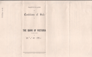
Legal record - ELLIS Edward Woodrow Tregenza - Land sale records, Watson, James & Rogers, Rogers Collection, 1907
... Land sales... Putnam Land sales Signatures * Particulars, conditions of sale ...In the early 1980s the firm of Watson, James & Rogers merged with the partnership of Every & Every and became the iconic “Rogers & Every” as known today. The firm is still located on Bull Street. https://rogersevery.com.au/about/* Particulars, conditions of sale and contract from bank of Victoria to Louisa Mary Ellis. 1907. * Plan of subdivision of crown allotments 20, 22, 23 Parish of Sandhurst, County of Bendigo * Agreement between Rupert Noyes Putnam of Williamson St. Bendigo and Edward Woodrow Tregenza Ellis of High St Bendigo for Crown allotments 18 and 19, Parish of Sandhurst County of bendigo.Signaturesrupert noyes putnam, land sales -
 Mont De Lancey
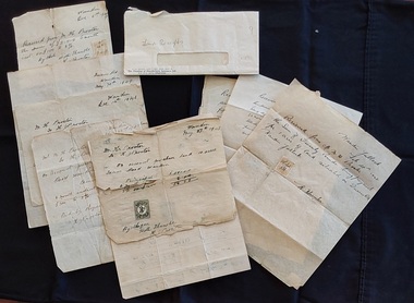
Document - Land Receipts, M. H. Proctor, H. Proctor & W Hunter, 1946 - 1951
... Land sales... Documents Land sales Contracts All letters are handwritten ...These are handwritten land receipt documents between Maxwell Proctor and W. Hunter (owner) 1946 - 1951 and between M.H. Proctor and H. Proctor 1947, 1948 and 1949.Two sets of handwritten land receipts in a used envelope with blue type at the bottom: Chamber of Manufactures Insurance Ltd. The first set of three receipts are written in copperplate handwriting for Mr. M. H. Proctor and are for the purchase of land, from W. Hunter (owner of the land). They are dated Feb 28th 1946, 17th April 1951 and an indecipherable date o the last one. The second set of six handwritten receipts are from M. H. Proctor to H. Proctor for land purchased: May 27th 1947, Dec 7th 1947, June 22nd 1948, Dec 14th 1948, May 30th 1949 and Dec.6th 1949. All letters are handwritten with a small green or yellow 3d. official Stamp Of Victoria glued to them. They are all signed by W Hunter or H. J. Proctor.legal documents, documents, land sales, contracts -
 Bendigo Historical Society Inc.
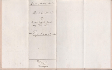
Legal record - FOGGITT JONES & CO. Land sale notes, Watson, James & Rogers, Rogers Collection, 1.7.1913
... Land sales... on Bull Street. https://rogersevery.com.au/about/ Land sales ...In the early 1980s the firm of Watson, James & Rogers merged with the partnership of Every & Every and became the iconic “Rogers & Every” as known today. The firm is still located on Bull Street. https://rogersevery.com.au/about/Sale notes to sell land in (Residence Areas), Wade St. Golden Square to Foggitt Jones & Co. Sold all Rights to Titles and Interests. Typed on light brown paper. 1. Joseph Mitchell and Mary Ann Roberts (10317 and 10318) 2. Elizabeth Roberts (10319) 3. Alice Emily Ann Roberts (13126) 4. John Frances Roberts (10363) 5. William Davies Osborne (9805) Release by Mrs Irene Catherine Orrock for Foggitt Jones & Co. handwritten on cream coloured paper.Signatures.land sales, foggitt jones and co. -
 Bendigo Historical Society Inc.
Administrative record - Mallee Index
... relating to land sales. Date unknown. ... to land sales. Date unknown. Administrative record Mallee Index ...Blue and red Index book. The book contains list of names in alphabetical order, next to the names a series of numbers. Possibly relating to land sales. Date unknown. Mallee index on the spineledger, name index, mallee -
 Kew Historical Society Inc
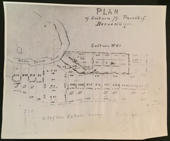
Print - Subdivision Plan (copy), Plan of Section 79 Parish of Boroondara (Clifton Estate), Nineteenth Century
... represent the first land sales in Kew in the area north of Studley... of Victoria. The numbered lots represent the first land sales in Kew ...This work forms part of the collection assembled by the historian Dorothy Rogers, that was donated to the Kew Historical Society by her son John Rogers in 2015. The manuscripts, photographs, maps, and documents were sourced by her from both family and local collections or produced as references for her print publications. Many were directly used by Rogers in writing ‘Lovely Old Homes of Kew’ (1961) and 'A History of Kew' (1973), or the numerous articles on local history that she produced for suburban newspapers. Most of the photographs in the collection include detailed annotations in her hand. The Rogers Collection provides a comprehensive insight into the working habits of a historian in the 1960s and 1970s. Together it forms the largest privately-donated collection within the archives of the Kew Historical Society.A photographic reproduction of a plan in the Vale Collection of the State Library of Victoria. The numbered lots represent the first land sales in Kew in the area north of Studley Park Road.maps (kew), plan of section 79 parish of boroondara -
 Ringwood and District Historical Society
Flyer, Land Sale Advertisement - East Ringwood Township Estates, East Ringwood, Victoria - circa 1920
... land sales in East Ringwood Township including maps showing.... Advertisement for three retail and residential allotment land sales ...The date of the flyer as circa 1920 can be estimated from the references to the (decision on) "electrification of the Croydon Railway Line" which eventually occurred in 1923, letting of tenders for the state school building which opened in 1924, and the "proposed new railway station" (East Ringwood) which opened in 1925, Advertisement for three retail and residential allotment land sales in East Ringwood Township including maps showing layout of subdivisions. Township Estate, State School Estate, and East Ringwood Station Estate.Subdivision plans include Mount Dandenong Road, Grey Street, Eastfield Road, King Street, Everard Road, Holland Road, Purser Avenue, and Charles Street. (Agents) Spencer Jackson, Subdivider & Homebuilder, 341 Collins Street, Melbourne, Phones: M2327 (3 lines), also at Dromana, Phone 65. -
 Bendigo Historical Society Inc.
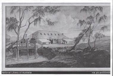
Photograph - BENDIGO POST OFFICE 1854
... in first land sales. Source of information: Dr. Ralph Birrell... Pyke, land purchased for 1800 pounds in first land sales ...Photo: copy of photo of first Bendigo Post Office and Survey Office, located corner of Mitchell and Pall Mall. Building constructed by John Pyke, land purchased for 1800 pounds in first land sales. Source of information: Dr. Ralph Birrell. This reproduction is the property of the National Library of Australia, and is not for reproduction in any form apart from for research.bendigo, buildings, post office and survey office -
 Kilmore Historical Society
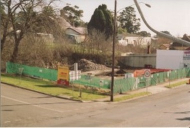
Photograph, Mobil Garage, 2006
... . Sign for the Willowmavin Estate is visible advertising land... Estate is visible advertising land sales. Multiple photographs ...Previously Mobil Garage owned by Danny and Pat D'Elia until 2001. Then demolished in 2006.15cm x 10cm colour photograph of the corner of Lancefield Road and Sydney Street. Printed on matte photographic paper (Kodak brand) Recent demolished building with rubble piled up and green security fencing around the perimeter of the property. Sign for the Willowmavin Estate is visible advertising land sales. Multiple photographs with multiple views available.Printed on back: Development information: Premier service station, construction sites -
 Kilmore Historical Society
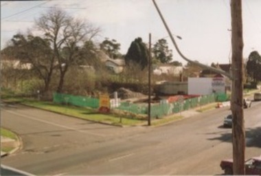
Photograph, Mobil Garage, 2007
... . Sign for the Willowmavin Estate is visible advertising land... for the Willowmavin Estate is visible advertising land sales. Multiple ...Previously Mobil Garage owned by Danny and Pat D'Elia until 2001. Then demolished in 2006.15cm x 10cm colour photograph of the corner of Lancefield Road and Sydney Street. Printed on matte photographic paper (Kodak brand) Recent demolished building with rubble piled up and green security fencing around the perimeter of the property. Sign for the Willowmavin Estate is visible advertising land sales. Multiple photographs with multiple views available.Printed on the back: Development information: PREMIER service stations, construction sites -
 Ringwood and District Historical Society
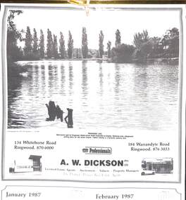
Souvenir - Complimentary A.W.Dickson Real Estate Agents calendars, Complimentary A.W.Dickson Real Estate Agents calendars - 1987 and 1988.1987 calendar with photographic images of local Ringwood features and 1988 calendar featuring local Ringwood land sale promotional images from early 20th Century
... early 20th century land sales in Ringwood, Heathmont... early 20th century land sales in Ringwood, Heathmont ...A.W.Dickson was a Real Estate Agent in Ringwood for many years. These calendars show the local buildings of the day. For example the original Eastland 's building of 1967, Maroondah Hospital 1976 and the Civic Centre now the Karralyka Centre.1 1987 calendar with six black and white photos of buildings and vistas around Ringwood with monthly dates in lower quarter of page. 2 1988 calendar with six posters advertising early 20th century land sales in Ringwood, Heathmont and Ringwood East with dates in lower quarter of page Compiled by A.W.Dickson Pty. Ltd. Real Estate Agent. Photographed by C.M.S. Photographers - 725 9441 (January February 1987) RINGWOOD LAKE - Ideal picnic spot for Ringwood Model power boats frequently on display. Barbecue area, playground, resting place for old steam engine. Yabbie netting is a favourite pastime here. (March April 1987) CLOCK TOWER - Moved from its former site on Warrandyte Road corner in 1967 and re-built in its present location, brick by brick. A wreath laying ceremony is held here on Anzac day each year. (May June 1987) RINGWOOD AQUATIC CENTRE - A world class swimming facility opened in 1986 at a cost of $3 million. Featuring the latest ozone water treatment techniques. In summer folding doors can be opened to give access to existing outdoor pools and sunbathing area. (July August 1987) MAROONDAH HOSPITAL - Opened in 1976 after many years of fund raising efforts by local people. The opening of casualty facilities was welcomed by locals as previously Box Hill Hospital catered for the entre area. (September October 1987) EASTLAND - Opened October 1967. Built on a former football oval. Now about to undergo major extensions to cater for Ringwood's population growth into the 21st Century. November December 1987 CIVIC CENTRE - Built on the site of a former antimony mine behind the council offices. Now the venue for many activities and a local point for Ringwood's Cultural Life. -
Kew Historical Society Inc
Archive (series) - Subject File, Kew Historical Society et al, 'Iveagh', Studley Park Road, 1993
... the history of Iveagh in Studley Park Road, Kew from the earliest land... from the earliest land sales to the ownership of the house ...Various partiesReference, Research, InformationSecondary Values (KHS Imposed Order)Subject file containing a 16-page manuscript recording the history of Iveagh in Studley Park Road, Kew from the earliest land sales to the ownership of the house by the Pallottine Fathers. Jean-Marie Labdanum and Dorothy Lyons created the manuscript in 1993 as part of a school research project. [There is also an article in KHS Newsletter 107, June 2014 by Kerry Fairbank on the history of the building].kew historical society - archives, kew - history, pallotine fathers, iveagh - 169 studley park road - kew (vic), john bakewell, richard goldsborough, william de graves, john mckenzie, john miller, thomas greenwood, thomas nankivell, george ramsden, patrick mcginnis, studley heights estatekew historical society - archives, kew - history, pallotine fathers, iveagh - 169 studley park road - kew (vic), john bakewell, richard goldsborough, william de graves, john mckenzie, john miller, thomas greenwood, thomas nankivell, george ramsden, patrick mcginnis, studley heights estate -
 City of Moorabbin Historical Society (Operating the Box Cottage Museum)
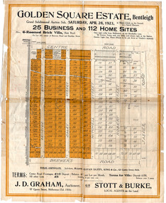
Flyer - Golden Square Estate, Bentleigh, 1923
... Land sales in the Municipality of Moorabbin increased when... Cottage Museum) Joyce Park Jasper Road Ormond melbourne Land sales ...Land sales in the Municipality of Moorabbin increased when the train line from the City to Frankston was electrified.Example of the progress of the Municipality of MoorabbinThe train line from the city to Frankston was electrified which intensified the sale in the municipality of Moorabbin, particularly land which was in the vicinity of the railway stations.Golden Square Estate, Bentleigh - J. D. Graham, Stott & Burke - 25 business sites and 112 home sitescentre road, brewers road, jasper road, robert street, mitchell street, daley street, bendigo avenue, auction, real estate, moorabbin, bentleigh -
 City of Moorabbin Historical Society (Operating the Box Cottage Museum)
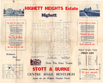
Flyer - Highett Heights Estate, Highett
... Land sales in the Municipality of Moorabbin increased when... Cottage Museum) Joyce Park Jasper Road Ormond melbourne Land sales ...Land sales in the Municipality of Moorabbin increased when the train line from the City to Frankston was electrified.Example of the progress of the Municipality of MoorabbinAdvertising flyer for auction of real estate sales - plan of building blocks for saleHighett Heights Estate, Highett - Stott & Bourke 58 home siteswickham road, hillcrest avenue, grandview road (now seaton road), maroona road, spring road, real estate, highett, moorabbin -
 City of Moorabbin Historical Society (Operating the Box Cottage Museum)
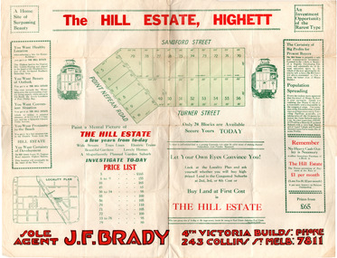
Flyer - Hill Estate, Highett
... Land sales in the Municipality of Moorabbin increased when... Cottage Museum) Joyce Park Jasper Road Ormond melbourne Land sales ...Land sales in the Municipality of Moorabbin increased when the train line from the City to Frankston was electrified.Example of the progress of the Municipality of MoorabbinAdvertising flyer for auction of real estate sales - plan of building blocks for saleThe Hill Estate, Highett - 24 Housing Blocks - J. F. Bradypoint nepean road (nepean highway), turner street, sanford street, real estate, highett -
 City of Moorabbin Historical Society (Operating the Box Cottage Museum)
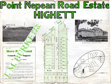
Flyer - Point Nepean Road Estate, Highett, 1937
... Land sales in the Municipality of Moorabbin increased when... Cottage Museum) Joyce Park Jasper Road Ormond melbourne Land sales ...Land sales in the Municipality of Moorabbin increased when the train line from the City to Frankston was electrified.Example of the progress of the Municipality of MoorabbinAdvertising flyer for auction of real estate sales - plan of building blocks for sale, pictures of landmarks.Point Nepean Road Estate, Highett T.M. Bourkepoint nepean road (nepean highway), alison street, william street -
 City of Moorabbin Historical Society (Operating the Box Cottage Museum)
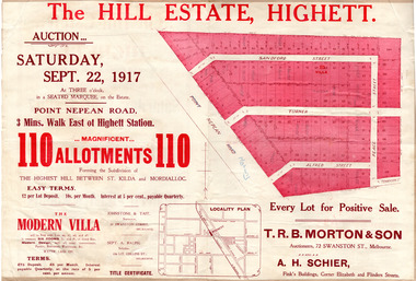
Flyer - The Hill Estate, Highett, 1917
... The land sales in the area stopped due to the 1890s... Cottage Museum) Joyce Park Jasper Road Ormond melbourne The land ...The land sales in the area stopped due to the 1890s depression. For the next 20 years real estate sales virtually stopped until after WWI.Example of the progress of the Municipality of MoorabbinAdvertising flyer for auction of real estate sales - plan of building blocks for saleThe Hill Estate, Highett - 110 allotments - Auction Saturday September 22, 1917 T.R.B. Morton & Sonpoint nepean road (nepean highway), turner street, sanford street, alfred street, peace street, highett, real estate, moorabbin -
 City of Moorabbin Historical Society (Operating the Box Cottage Museum)
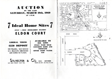
Flyer - Eldon Court, Moorabbin
... In the mid 1900's land sales in Moorabbin began... 1900's land sales in Moorabbin began of the remaining market ...In the mid 1900's land sales in Moorabbin began of the remaining market gardens which were being sub divided. Eldon Court was auctioned off in 1960Example of the progress of the Municipality of MoorabbinPhotocopy of advertising flyer for auction of real estate sales - plan of building blocks for saleEldon Court, Moorabbin - 7 Home sites - Saturday March 19 1960eldon court, moorabbin, real estate, auction -
 Bendigo Historical Society Inc.
Legal record - Land Register
... contains plans of Land sales for a broad area of Central Victorian... (!!). Register contains plans of Land sales for a broad area of Central ...Land register for duration 1924 to 1951 (!!). Register contains plans of Land sales for a broad area of Central Victorian Parish / Counties. Register has a stiff blue card cover originally bound with light brown leather spine and corners, presently in a dire condition with cover damaged and loose; plans also folded and damaged. Plans inserted as drawn plans within the register, later plans are included on tracing, paper and linen - in various degrees of condition / damage.land register, central victoria -
 Kew Historical Society Inc
Photograph - Yarra River, Kew, 1925
... at Kew. From the 1840s, at the Crown Land Sales, lots adjacent... Land Sales, lots adjacent to the river were sold and developed ...Henry Beater Christian (1886-1962) , was a descendant of one of the earliest settler families in Kew. Employed at the Kew Asylum as a 'public servant', he was a skilled amateur photographer, photographing numerous scenes in Kew and on his travels around Victoria. The majority of his photographs date from 1916 to 1929. His finest photographs are housed in two photograph albums. Digital copy of a photograph from page 3 of the 47-page photograph album containing 261 gelatinous silver images, loaned by Diane Washfold with permission given to digitise and hold a copy in our collection. A photograph of a stretch of the Yarra River at Kew. From the 1840s, at the Crown Land Sales, lots adjacent to the river were sold and developed as dairy farms, hence the presence of cattle until the land was subdivided or created into golf courses during the twentieth century. "Yarra Rvr / Kew / 1925"henry beater christian (1886-1962), landscape photography, kew (vic.) — yarra river, christian-washfold collection, photograph albums, dairying -- kew (vic.) -
 Bendigo Historical Society Inc.
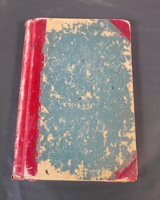
Book - LANDS OFFICE: INDEX LANDS AND SURVEY
... , White Hills, And Nerring. Land Sales, Beginning April 17, 1854..., Kangaroo Flat, Eaglehawk, White Hills, And Nerring. Land Sales ...Index lands and Survey. Sandhurst, Kangaroo Flat, Eaglehawk, White Hills, And Nerring. Land Sales, Beginning April 17, 1854. The last entry is dated 23.9.74. markings on spine of book are at top 04 in black, in gold lettering index lands and Survey, in black Bendigo, Eaglehawk, Kangaroo Flat White Hills and Nerring, near the bottom is the letter B in black, a white sticker with the letters VV. Read in conjunction with 2239 (a to g), located in Box 77.lands office, index, survey -
 Ringwood and District Historical Society
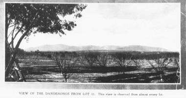
Photograph, Mullers orchard, Heathmont. Looking east from cnr. Canterbury and Dickasons Rds. "Charm View Estate" - 1926
... on back of a photograph, "Photo taken from sub. div. plan land... land sales. Charm View Estate, Heathmont, 1926?" Another copy ...Printed below photograph, "View of the Dandenongs from Lot 11. This view is observed from almost every lot". Written on back of a photograph, "Photo taken from sub. div. plan land sales. Charm View Estate, Heathmont, 1926?" Another copy reads, "Mullers orchard, Heathmont. Taken from cnr. Canterbury and Dickasons Rds. Looking east - 1926". -
Port Melbourne Historical & Preservation Society
Audio - PMHPS Meeting, Frank Callaghan, Frank Gordon & Co, Estate agents, Glen Stuart, 25 May 1998
... from Estate Agents Frank Gordon & Co. Discussing land/property... land/property sales in Port. Recording duration 49:36. Audio ...Recording of PMHPS Meeting on 25.05.1998. Recording done by Glen STUART at Port Town Hall. Speaker was Frank CALLAGHAN from Estate Agents Frank Gordon & Co. Discussing land/property sales in Port. Recording duration 49:36.business and traders, frank gordon & co, frank callaghan, built environment - domestic -
 City of Moorabbin Historical Society (Operating the Box Cottage Museum)
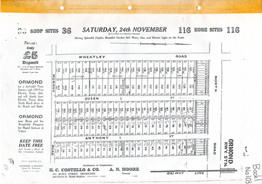
Flyer - Brennan's Estate, Ormond - H. C. Costello & Co, 1923 - 1924
... Land sales in the Municipality of Moorabbin increased when... Cottage Museum) Joyce Park Jasper Road Ormond melbourne Land sales ...Land sales in the Municipality of Moorabbin increased when the train line from the City to Frankston was electrified. Brennan's Real Estate, Ormond 116 home sites and 36 Shop sites was auctioned on three occasions in order to sell building lots that had failed to sell at the previous action.Example of the progress of the Municipality of MoorabbinAdvertising flyers for auction of real estate sales - plan of building blocks for saleBrennan's Real Estate, Ormond 116 home sites and 36 Shop sites was auction on three occasionsnorth road, wheatley road, queen street, anthony street, murray road, h. c. costello & co, a. n. moore, ormond, real estate, auctions -
 Kew Historical Society Inc
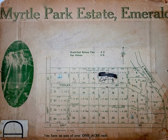
Plan - Subdivision Plan, Myrtle Park Estate, Emerald, 1915
... to land sales in Emerald, Victoria, rather than to the subdivision...’ relates to land sales in Emerald, Victoria, rather than ...This subdivision plan for the ‘Myrtle Park Estate’ relates to land sales in Emerald, Victoria, rather than to the subdivision of the same name in East Kew (1913-16). The subdivision in Emerald included 32 one-acre lots facing Torley Road, Government Road (now Rawhiti and Wong Hee Roads) Beaconsfield Road (now Old Beaconsfield Road). On the plan, an unnamed creek flows through allotments 8-12 on the east side of the Estate. The photograph of a waterfall and the advertised price of Day Return and Weekend Return Fares provide an indication of who the prospective purchasers were likely to be.subdivision plans - emerald, myrtle park estate, torley road -- emerald (vic.) -
 Ringwood and District Historical Society
Photograph, Club Hotel, Mount Dandenong Road, Ringwood East in 1924, 1924
... the "Ringwood East Electric Station Estate" land sales brochure dated... the "Ringwood East Electric Station Estate" land sales brochure dated ...Black and white photograph of the Club Hotel on Mount Dandenong Road, East Ringwood. The image was copied from the "Ringwood East Electric Station Estate" land sales brochure dated 1st November 1924. Refer to #5132. The hotel has a long association with the Reddish family, thus given the name of "Daisy's Hotel". Included 2 copies of the photograph. Ryman Healthcare bought the site in 2019, including the garden supply business next door, making up a 2.2ha area. The proposal was for a $220 million retirement village to be built. The location is next to Ringwood Lake with the old hotel being knocked down in the early 2020s.Was item H7 in the previous numbering system. -
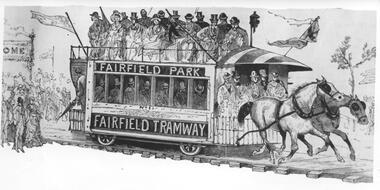 Melbourne Tram Museum
Photograph - Black & White Photograph/s, c1890
... . The drawing is from a series of sketches at one of the Saturday land... of sketches at one of the Saturday land sales. The tramcar is numbered ...Black and white photograph of an illustration of the Fairfield Horse Tram. The illustration is from The Australasian Sketcher with Pen and Pencil (Melbourne, Vic. : 1873 - 1889), No 188 Vol XIIL, 14/1/1885. The magazine was owned by the Argus. The drawing is from a series of sketches at one of the Saturday land sales. The tramcar is numbered 1 and has signage Fairfield Park and Fairfield Tramway. The tramway was operated by Charles Henry James in an attempt to sell land developed by him north of the Fairfield railway station. The tramway operated from 20/12/1884 until its closure in 1890. Stamped on the back "...The Argus...negative No X2656"trams, tramways, argus, fairfield, horse trams, tram 1 -
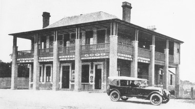
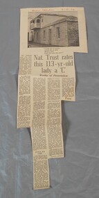 Bendigo Historical Society Inc.
Newspaper - Lydia Chancellor collection: Specimen cottage
... land sales in 1854. It is possibly the earliest building still... land sales in 1854. It is possibly the earliest building still ...Specimen Cottage in Hargreaves Street Bendigo was built by stonemason James Brierley in 1856. He purchased the land at the first land sales in 1854. It is possibly the earliest building still standing in Bendigo. Further information "Written in Stone - The Story of pioneer Bendigo Stonemason James Brierley and his family" Written by Barbara Poustie. Published in 2017. Printed by Bendigo Historical Society.Bendigo advertiser from 04/10/1969. Article titled: Nat. Trust rates this 113 years old lady a "C" details the history of Specimen cottage. In red pen Bendigo Advertiser 4-10-69bendigo building, specimen cottage, james brierly, national trust