Showing 11577 items matching " maps"
-
 Anglesea and District Historical Society
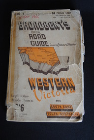
Road Directory, Broadbent's Official Road Guides Company, Broadbent's Official Road Guide Western Victoria, 1956
... Maps ...Contains maps and advertisements for Western Victoria in 1956 as well as some of South-East of South Australia. 240 pages. Fold out maps included.Circa 1956maps, advertisements, broadbent -
 Whitehorse Historical Society Inc.
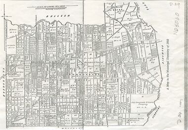
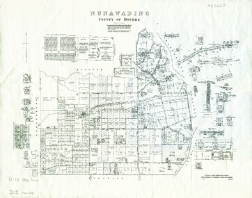
Map, Shire of Nunawading, 1892
... maps ...Map of the Shire of Nunawading in the Municipal Directory of 1892e of NunawadingPhotocopy of a map of the Shirew of Nunawading in the Municipal Directory of 1892 showing land owners.Map of the Shire of Nunawading in the Municipal Directory of 1892e of Nunawadingmaps, shire of nunawading -
 Whitehorse Historical Society Inc.
Map, Map of Mont Albert, Box Hill, Surrey Hills and Blackburn, c 1933
... Maps ...Map of Box Hill and Surrounds, showing location of Box Hill Grammar School.Map of Box Hill and Surrounds, showing location of Box Hill Grammar School.Map of Box Hill and Surrounds, showing location of Box Hill Grammar School.maps, box hill grammar school -
Whitehorse Historical Society Inc.
Map, Map of City of Nunawading, n.d
... Maps ...Hand drawn map of City of Nunawading showing heights above sea level.city of nunawading, maps -
Stawell Historical Society Inc
Map - Electoral Map, Victorian Government, Map of North - Western ( Country) Electoral Province Legislative Council 1939, 1939
Electoral MapMap Overprinted with Provinces In RedScale 8 Miles to 1 Inchgovernment -
 Halls Gap & Grampians Historical Society
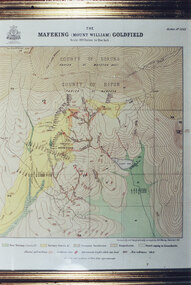
Photograph - Coloured, C 1900
... MAPS ...Colour photo of framed map of Mafeking Goldfield.mining, mafeking, maps -
 Running Rabbits Military Museum operated by the Upwey Belgrave RSL Sub Branch
Map
... Maps ...Viet Cong Map of Nui Dat Areamaps, vietnam, general -
 Bacchus Marsh & District Historical Society
Map, Village allotments, Parish of Myrniong, County of Bourke
Myrniong is a village 9 kilometers west of Bacchus Marsh. Prior to 1863 the area was known as Blow's Flat. This map which was produced in 1903 and according to the catalogue record of this map held at the State Library of Victoria was based on an earlier map created in 1861. The early layout of streets for the village of Myrniong can be seen on this map. The streets shown are, Main Street, Hardy Street, Blow Street, Myrniong Street, Shuter Street, and Blackwood Street. An area marked as a reserve for a school can be seen between Hardy Street and Main Street.A single page paper map. A cadastral parish map of Myrniong in Victoria, showing numbered land allotments. Photo-lithographed at the Department of Lands & Survey, Melbourne, in 1903. Based on an original map created in 1861. The map is pasted into a bound volume containing 76 maps or plans in total. High resolution digital image stored on BMDHS computer network. Surveyed by John Hardy, Surveyor ; photo-lithographed at the Department of Lands & Survey, Melbourne by T.F. McGauran, 24.12.03myrniong parish plan, myrniong parish maps -
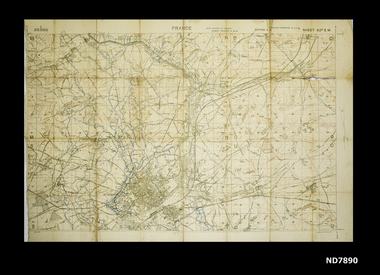 Whitehorse Historical Society Inc.
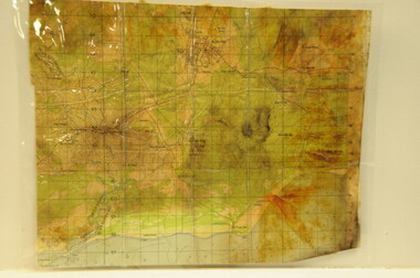
Map, Area map of France trench map, 03/02/1918
... Maps ...Coloured trench map of part of France Sheet 62B S.W. Scale 1 : 20,000non-fictionColoured trench map of part of France Sheet 62B S.W. Scale 1 : 20,000maps, world war 1914 - 1918 -
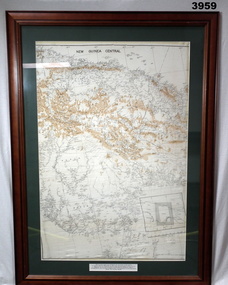 Bendigo Military Museum
Map - MAP, NEW GUINEA FRAMED, C. 1941 onwards
Map of central section of New Guinea. Black print on white background with mountain ridges in tan. Map is mounted with green border. Brown wooden frame, glass front, white cardboard backing with wire hanging strap on back. Map prepared under the direction of RAAF Headquarters.Printed in black top centre: “NEW GUINEA CENTRAL” Printed on border under map: “These escape maps were carried in the zip pocket of life jackets by fighter pilots in WW2. This map was presented to A.S.R. on 12.7.79 by Councillor Ian McKenzie, Mayor of Eaglehawk, who served as a fighter pilot in 78th SDN in the SW Pacific area during 1943-44.”map, new guinea, central, raaf -
Clunes Museum
Pamphlet - TOUR AND MAP, RICHARD AITKEN, TALBOT WALKING TOUR, 1988
PUBLISHED FOR BICENTENNIAL COMMEMORATION 1988TALBOT WALKING TOUR AND MAP. PUBLISHED BY TALBOT AND CLUNES HERITAGE PROJECT. WRITTEN BY RICHARD AITKEN, 1988PHOTO OF TALBOT TOWN HALL; HISTORY; DESCRIPTIONS OF BUILDINGS AND MAPtalbot, tour, map, 1988, aitken -
Clunes Museum
Map - MAP OF CLUNES, CHARLES FENTON
THESE MAPS WERE SOLD IN CLUNES MUSEUM PRIOR TO TH REDEVELOPMENTOF THE WAREHOUSE BY HEPBURN SHIRE COUNCIL. MAPS WERE SOLD FOR $ 1.504 COPIES OF MAP OF CLUNES 1987map, clunes 1987, charles fenton, map of clunes -
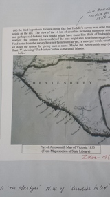 Peterborough History Group
Document - Peterborough survey, Heytesbury District
About Peterborough town and the surrounding Council districts, coastal survey and mapshistory of the development of the townMaps, photocopiesflaxman hill, peterborough history, heytesbury, peterborough 3270 -
Whitehorse Historical Society Inc.
Map, Shire of Blackburn and Mitcham, 1928
... Maps ...Combination of two sheets of detailed map.Combination of two sheets of detailed map. Many subdivisions shown in details with lot numbers.Combination of two sheets of detailed map. maps, shire of blackburn and mitcham -
Whitehorse Historical Society Inc.
Map, City of Nunawading, n.d
... maps ...Map of the City of Nunawading with streets and railway stations namedMap of the City of Nunawading with streets and railway stations named Scale 1 mile = 3.75 inMap of the City of Nunawading with streets and railway stations named city of nunawading, maps -
Whitehorse Historical Society Inc.
Map, City of Nunawading, 21/10/1994 12:00:00 AM
... Maps ...Map showing streets in the City of Nunawading, prep. by M. Day Scale 1:15,000Map showing streets in the City of Nunawading, prep. by M. Day Scale 1:15,000Map showing streets in the City of Nunawading, prep. by M. Day Scale 1:15,000city of nunawading, maps -
 Kiewa Valley Historical Society
Map of the Ovens and Murray District of Victoria
The map features Beechworth and its history.This map features the north-east and in particular, Beechworth where residents of the Kiewa Valley may have shopped or visited for appointments.Black and white map with references to roads and gold. The centre of the map is Beechworth and in the bottom left side of the map is the heading Beechworth with 12 lines of print of information regarding Beechworth. The Kiewa Valley is not identified.beechworth -
Clunes Museum
Map - CLUNES MT GREENOCH TALBOT GOLDFIELDS
... maps ...MAP OF CLUNES GOLDFIELDS CIRCA 1883 .1 PAPER UNMOUNTED, SEPIA, .2 BORDER MOUNTED, COLOURED .3 COPY OF MAP BLACK ANDWHITE .4 ORIGINAL MAP, COLOURED, HAS CANVAS BACKINGCLUNES MT GREENOCK TALBOT GOLDFIELDS local history, document, maps, mining -
 Bacchus Marsh & District Historical Society
Map, Coimadai Parish Map, County of Bourke. Circa 1890s-1900s
The cadastral Parish of Coimadai, a subdivision of the County of Bourke, lies directly north of the township of Bacchus Marsh. The date of this map is uncertain. T.F. McGauran the person who made a photo-lithographic copy of the map was in charge of photo-lithography at the Victorian Department of Lands and Survey in the late 19th century until about 1910.A single page paper map showing the map for the Parish of Coimadai in the County of Bourke. A cadastral map showing parish boundaries and land ownership. A rectangle shaped area is missing from the centre of the map due to a tear or deliberate excision. The map is pasted into a bound volume containing 76 maps or plans in total. High resolution digital image stored on BMDHS computer network. Photo-lithographed at the Department of Lands and Survey, Melbourne by T.F. McGauran 26.8.[??] NOTE. Photo litho from L.P showing temporary surveys and occupation of land prepared for departmental use onlybacchus marsh region parish plans, coimadai parish maps, coimadai parish plan -
 Whitehorse Historical Society Inc.
Map, Nunawading, 1970
... maps ...Reprint of original map of Shire of NunawadingReprint of original map of Shire of Nunawading with various update but mostly showing 19th century landholders.Reprint of original map of Shire of Nunawadingmaps, shire of nunawading -
Whitehorse Historical Society Inc.
Pamphlet, Exploring your sanctuary, 2005
... Maps ...Long and short walks around Blackburn Lake Sanctuary, incl. map. Rev. ed. 2005.Long and short walks around Blackburn Lake Sanctuary, incl. map. Rev. ed. 2005.Long and short walks around Blackburn Lake Sanctuary, incl. map. Rev. ed. 2005.blackburn lake sanctuary, maps -
 Greensborough Historical Society
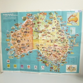
Map, International Harvester, Australia. Land of tomorrow, 1965_
This 1960s map of Australia shows areas of economic development at that time.Colour map of Australiaaustralia economic development, international harvester -
 Creswick Campus Historical Collection - University of Melbourne
Map, Creswick, 1943
Dept of Lands and Survey map of Creswick and county of Talbot. 2 linen backed sheets rolled into white cardboard cylinderMaps -
 Federation University Historical Collection
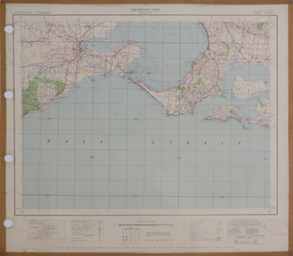
Map, Queenscliff, 1942, 1942
Two copies of printed colour map on paper showing Queenscliff and surrounds"This map in an official document, if found, it must be handed in to the nearest military headquarters or police station."queenscliff, portsea, point nepean, point lonsdale, barwon heads, geelong, corio bay, port phillip bay -
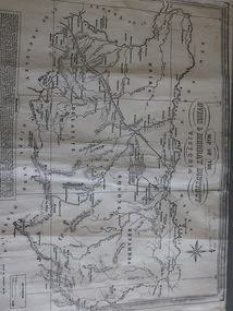
Federation University Historical Collection
Plan (copy), Frederick Proeschel, Map of the Roads to all the Gold Mines in Victoria, 1853
The map was pirated from Frederick Proeschel's "Pocket Map of the Roads to all the Gold Mines in Victoria" issued earlier in 1853.Digital file of the Map of the Roads to all the Gold Mines in Victoria. The map has been coloured to show routes to the Victorian goldfields from Melbourne and Geelong.frederick proeschel, proeschel, gold, mining, philp -
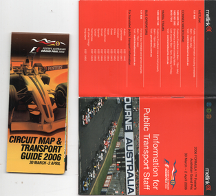 Melbourne Tram Museum
Booklet, Metlink, "Information for public transport staff - 2006 Formula 1 Australian Grand Prix", 2006
Gives details of event for train, tram and bus crews, event program and transport map, including shunting details, announcements, bus replacement services, electric or automatic points, route alterations. On the back cover has contact telephone numbers and web addresses - Published by Metlink. Fold out map gives a detail map of the course, locations for transport and details of the event - published by the Grand Prix corporation. Yields information the 2006 Grand Prix event at Albert Park.Set of 2 items - both within a clear plastic envelope. 1 - booklet 40 pages with foldout map centre stapled 2 - 16 fold map - circuit map and transport guide tramways, grand prix, metlink, formula 1, albert park -
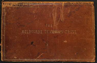 Melbourne Tram Museum
Document - Folder, Kemp & Boyce Printers, "Melbourne Tramways Trust - Cable Tramways", March 1889
... maps ...Plans and documents prepared by George Duncan for the Melbourne Tramways Trust showing details of the track construction, drainage and costs for the construction of the Melbourne cable tram and horse tram system for the Melbourne and Tramway Omnibus Co. Part 1 - track cross sections for both cable and horse trams and various rail weights - lbs/yard part 2 - details costs and mileages for each liine, report from George Duncan and remnant part of a printed map missing the lower half. part 3 - drainage report detailing the works and cost for each line. part 4 - continuation of drainage report - and last part of the book Map printed on cloth - blue print - showing the various lines. Note the Windsor to St Kilda line shown as a horse tram line, but was built as a cable line - the last to be opened.Yields information about the construction of the cable tram system by the Melbourne Tramway TrustFolder - heavy card leather covered covers with gold lines around the edges and gold blocked title. Has marbled glued end papers, containing 9 cloth backed blue print drawings, 22 printed sheets and two foldout maps. The lower half of the first fold out map has been torn out and lost. The second fold out map, a cloth backed blue print.Date stamped in two places with "The Melbourne Tramways Trust Engineers 9 Mar 89" (1889), in two places.tramways, trams, cable trams, mtt, mtoco, melbourne tramway trust, construction, drainage, maps, george duncan, track work, costs -
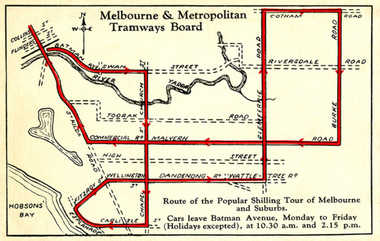 Melbourne Tram Museum
Drawing - Digital Image, Shilling Tour Map, 1927
Map shows the route of the Shilling Tour Map, using Y469 - shows the direction of travel and departure times from Batman Ave. Destination City 5th Edition notes that the services with the tram commenced in June 1927.Yields information about the MMTB's 1927 Shilling tour of Melbourne.Digital Image of an MMTB Map.trams, tramways, y class, tours, tourist trams, tourist trips, tram 191 -
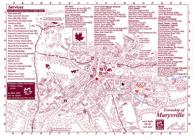 Marysville & District Historical Society
Map (Item) - Information map, Michael Hampton, 2000
An information map of the township of Marysville. This map was produced by McNamara Country Real Estate in 2000. The artist who drew the map was named Michael Hampton.An information map of the township of Marysville.MICHAEL HAMPTON/ 2000 VERSION 1:2/ 01/01marysville, victoria, australia, tourist map, information map, mcnamara country real estate, michael hampton -
B-24 Liberator Memorial Restoration Australia Inc
Map - Silk Map of South West Pacific Ocean, Ocen Currents and Surface winds of the West pacific Area May-October
These maps were carried by air crew flying in the Pacific Ocean areas.Square silk mapOCEAN CURRENTS AND SURFACE WINDS FOR THE WEST PACIFIC AREA MAY- OCTOBER COMPILED BY THE 2ND AND 3RD OPERATIONS ANALYSIS SECTIONS,HQ, FEAF, FROM OCEAN CURRENT CHARTS DEIGNED BY THE SCRIPTS INSTITUTE OF OCEANOGRAPHY, AND FROM WIND CHARTS PREPARED BY THE U.S. WEATHER BUREAU. REPRODUCED BY R.A.A.F HEADQUARTERS [cartographic section] OCTOBER 1944 RESTRICTED