Showing 1329 items
matching parks and reserves
-
 Eltham District Historical Society Inc
Photograph, Hans Gregory, Original 1860s William West house, Fabbro's Farm, Falkiner Street, Eltham, c.1990
Photos taken by Hans Gregory who along with partner Pauline Steele, rented the original old 1860s William West Cottage situated behind the Fabbro family home. Hans was employed as a Youth officer with the Shire of Eltham at the time and was the last tennant on the property. The property was sold and in 1995 was developed for residential housing as the Riverview Park estate. Guido Quarto Fabbro was born 21 August 1891 at Treppo Grande in the far northeast of Italy, the son of Giacomo Fabbro and Anna Geruzzi. Regina Moretti was born 6 March 1893 at Treppo Grande, Italy, the daughter of Giovanni Battista Moretti and Maria Teresa Coletti. Guido and Regina married about 1917 and they had two sons, Giacomo (John c.1918) and Maurie (c.1920). In 1925 Guido Fabbro departed his homeland from Genoa, arriving in Fremantle, Western Australia in June, travelling 3rd class aboard the ship, Caprera. Regina and their two boys followed a year later along with other family members arriving in Fremantle from Genoa 4 July 1926 aboard the Moncalieri. The Fabbros arrived in Eltham in 1933 and purchased a block of land from William West on the western side of Falkiner Street, extending to Ely and Porter Streets which had formerly been part of the West family orchard and dairy farm. As there was no fencing dividing the two properties, West served notice on Guido in December 1934 to bear half of the cost of £6. When payment was not forthcoming, West sued Guido in the Eltham Court in January 1935. Guido failed to appear and was not represented, and costs were ordered in West’s favour. Guido and Regina built a large Italianesque house on their property. The original 1860s cottage was relocated to the back of the block and was rented out (once to Alistair and Margot Knox). Guido also purchased land extending to the Diamond Creek on the eastern side of Falkiner Street and on the eastern side of Bell Street (opposite Eltham High School). The riparian soil was suitable for market gardening: Guido grew mainly tomatoes, but also pumpkins, cauliflowers, cabbages, peas, beans, lettuce, beetroot and zucchinis. Even the land surrounding the house was used. The produce was carted to Melbourne overnight for sale at the market. Guido died in 1970 and is buried in Eltham cemetery. Regina died 1986. She and their son John Patrick (Giacomo) Fabbro who died in 1984 are also buried at Eltham Cemetery. Guido’s son Maurie continued in his father’s footsteps until 2007, principally growing artichokes in later years. He died in 2009. The land on the eastern side of Falkiner Street now forms part of a Council reserve called “Barak Bushland”, the land on the western side having been sold off for residential subdivision. The Bell Street land is now public open space managed by Nillumbik Shire Council and called “Fabbro Fields”. There have been recent proposals to develop the site for sporting purposes or as a dog park or community garden. Provides an insight into early settler's farmhouses and farming property of the Eltham district.guido quarto fabbro, regina fabbro (nee moretti), william west, maurie fabbro, fabbro's farm, hans gregory, west family orchard, west dairy farm -
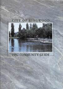 Ringwood and District Historical Society
Book, City of Ringwood, City of Ringwood 1992 Community Guide, 1992
Community information book issued by City of Ringwood for 1992 - covering the facilities and activities of the Ringwood Council and other local organisations and associations. Includes two Aquatic Centre entry vouchers valid until June 30th, 1992.CONTENTS: (page no.) 1991/92 COUNCIL REPRESENTATIVES 4 1992 CALENDAR 51 AQUATIC CENTRE 8 AQUATIC CENTRE VOUCHERS 49 CHIEF EXECUTIVE'S REPORT 6 CIVIC CENTRE TELEPHONE INDEX — DIRECT DIALLING 53 COMMUNITY DIRECTORY 35-47 COMMUNITY SERVICES 17-19 COUNCIL & COMMITTEE CYCLES 4 COUNCIL FINANCES & 1991/92 RATES 16 COUNCILLORS 3 FUNCTIONAL RESPONSIBILITIES 15 HISTORY OF RINGWOOD 5 HOUSING & RESIDENTIAL DEVELOPMENT 29-30 INFRASTRUCTURE 34 LOCAL, STATE & FEDERAL GOVERNMENT ELECTIONS 32 MANAGEMENT TEAM 14 MAYORAL MESSAGE – Cr. Max Williams 1 NEIGHBOURHOOD MAP 26-27 NOTES 52 PAPER & CARDBOARD COLLECTION SERVICE 22 PARKS & RESERVES — PUBLIC FACILITIES 31 PROTECTING OUR COMMUNITY 23-24 PROTECTING THE ENVIRONMENT 20-21 RINGWOOD FESTIVAL & HIGHLAND CARNIVAL 13 RINGWOOD GOLF COURSE 7 STRATEGIC BIKE PLAN 11 STREET INDEX A-L 25 STREET INDEX L-Z 28 THE LIBRARY 12 THE RINGWOOD CONVENTION & PERFORMING ARTS CENTRE 10 TRAFFIC MANAGEMENT 33 YOUR PERSONAL DIRECTORY 50 rinx -
 Bendigo Historical Society Inc.
Map - GUIDE MAP OF BENDIGO & EAGLEHAWK, Late 1920's
Map. Guide Map of Bendigo & Eaglehawk. Light brown coloured booklet containing folded map of Bendigo and Eaglehawk. Outer cover is printed in blue and red ink and states - With compliments of J H Curnow & Son, Auctioneers, Real Estate Agents, Farm & Dairy Produce Merchants, Bendigo. Printed by J B Young, Lithographer. Map shows tramways & bus routes. Map shows Agricultural Showgrounds located between Park Street, Water Street, Barnard Street and Bridge Lane. Also shows Acclimitization Reserve located behind The Botanical Gardens at White Hills. Shows the location of Sailors Gully, Peg-Leg Gully, Jobs Gully, California Gully, Long Gully, Ironbark Gully, Golden Gully, Poverty Gully, Sheepshead Gully, Charcoal Gully, Eaglehawk Creek, Bendigo Creek and Back Creek. Contains interesting facts about Bendigo - Area 7,900 acres. Population - 26,000. First Council elected - 1855. Proclaimed a Borough - 1863. Proclaimed a City - 1871. Gold Rush broke out - 1851. For first 10 years gold yield averaged 8,600 ozs. per week . Total gold yield to 1923 - 572 tons valued at 82,000,000 pounds. Deepest mines - Victoria Quartz 4,614 ft., New Chum Railway 4,318 ft. 13 mines over 3.000 ft. deep. 53 mines over 2,000 ft. deep. Sewering of City commenced 1922, all principal buildings now sewered. Map printed by Arnall & Jackson, General Printers, Stationers & Engravers, 476 Collins Street. Map displays advertisement for J H Curnow & Son, Bendigo's leading Auctioneer and Estate Agents, Mitchell & Queen Sts. Bendigo. Map Scale 20 chs. = 1 in.cottage, miners, guide map of bendigo and eaglehawk -
 Bendigo Historical Society Inc.
Map - GUIDE MAP OF BENDIGO & EAGLEHAWK, Late 1920's
Map. Guide map of Bendigo & Eaglehawk. Folded map of Bendigo & Eaglehawk with blue outer cover booklet. Map is compiled by E E Parker, Eaglehawk. Map shows tramways, bus routes and cost one shilling. Map shows Agricultural Showgrounds located between Park Street, Water Street, Barnard Street and Bridge Lane. Also shows Acclimitization Reserve located behind the Botanical Gardens at White Hills. Shows the location of Sailors Gully, Peg-Leg Gully, Jobs Gully, California Gully, Long Gully, Ironbark Gully, Golden Gully, Poverty Gully, Sheepshead Gully, Charcoal Gully, Eaglehawk Creek, Bendigo Creek and Back Creek.Contains interesting facts about Bendigo:- Area - 7,900 acres, Population - 26,000, First Council elected - 1855, Proclaimed a City - 1871. Gold Rush broke out - 1851. For first 10 years gold yield averaged 8,600 ozs. Per week. Total gold yield to 1923 - 572 tons valued at 82,000,000 pounds. Deepest mines - Victoria Quartz 4,614 ft., New Chum Railway 4,318 ft., 13 mines over 3,000ft. deep, 53 mines over 2,000 ft. deep. Sewering of City commenced 1922. All principal buildings now sewered. Map printed by Arnall & Jackson, General Printers, Stationers & Engravers, 476 Collins Street. Outer map blue cover printed in red and blue ink by J B Young, Lithographer. Map displays advertisement for Bendigo Timber Co. Outer blue cover displays advertisement for Campbell Connelly & Co. Pty. Ltd, Ironmongers, Timware Manufacturers, Plumbers, Sewerage Contractors, High and Forest Sts, Bendigo 9outside back cover) and for Hartleys ( J L Shoosmith) Bendigo, displaying Indian Motor Cycles (inside back cover).map, bendigo, township, guide map of bendigo & eaglehawk -
 Eltham District Historical Society Inc
Document, Russell Yeoman, Tour of Historic Buildings and Locations, 1978
Self guided heritage tour information produced by the Shire of Eltham Historical Society for 1978 Eltham Community Festival of 36 locations each numbered on accompanying map. Locations and detail provided current to 1978: 1. ELTHAM SHOPPING CENTRE Whilst very little remains in the centre of historical importance, this area has interest as the "village" which developed over many years following the opening of the railway from Melbourne in 1902. Previously the shopping centre had been spread out over a long length of Main Road to the south. Shops have been continuously demolished or remodelled and the majority of buildings date from the 1950's or later. The recently erected Post Office replaced the "old" Post Office opened on the same site only in 1958. 2. WOOLWORTHS ELTHAM VILLAGE Part of the site of this modern shopping development was occupied by the former Eltham Shire Offices and Hall. The hall was paid for by public subscription whilst the Council raised a loan for the offices. The combined building was opened in 1941. It served as office and Council meeting place until 1965 and as the hall until its demolition in 1970. 3. ELTHAM WAR MEMORIAL The complex of buildings adjoining the present Shire Offices were financed by public subscription as a Memorial following World War II. Their construction and for many years their operation was organised by the now disbanded Eltham War Memorial Committee. The original buildings were the; Infant Welfare Centre, Children’s Library (now War Memorial Hall and Dental Clinic) and Kindergarten. In later years the Elderly Citizens Club was built at the rear. 4. ELTHAM SHIRE OFFICES These offices were opened in 1965 and extended in 1971 to provide additional office accommodation and the Eltham Library. They represent the last of a long line of offices and meeting places of the Eltham Shire Council and its predecessor the Eltham District Road Board. The building occupies the former site of Shillinglaw Cottage. The three tall cypress trees which stood in front of the Cottage have been retained as a feature of the office surrounds. 5. OUR LADY'S CHURCH AND SCHOOL The Catholic Church and School complex opposite the Shires Offices shows a number of stages in the development of Eltham township. The recently constructed church adjoins its predecessor (now the parish centre). Many years ago the Catholic Church was located opposite Wingrove Park and the present central site follows the northerly drift of the township. 6. SHILLINGLAW COTTAGE The Cottage was built in 1859 by George Stebbing, a local builder who was responsible for a number of other prominent buildings in the area. Its removal from the site of the Shire Offices and re-erection on the present site was financed by public subscription. It is built of handmade bricks laid in Flemish Bond with an unusual design featuring burnt "leader" bricks over the whole facade. The Cottage is occupied by Eltham Fleececrafts and will be open during the Festival and at other times during weekends. It is classified by the National Trust. 7. RAILWAY BRIDGE The timber trestle bridge over the Diamond Creek was built in 1901. Whilst all of its timbers have been replaced at various times over the years the only change to its character has been the addition of pylons and wiring for electric trains in 1923. It is one of very few similar bridges remaining in the metropolitan area. In 1976 a proposal to replace the bridge with an earth embankment and large culvert pipes was abandoned following community protests. The bridge, however, remains under threat because of the necessity for future deuplication of the railway line. 8. ELTHAM CENTPAL PARK The area between the railway and the creek has for many years been used as a park which included Eltham' s main football oval. The access road, Panther Place is named after Eltham's team playing in the Diamond Valley League. In recent years a large area extending to Bridge Street and locally known as the Town Park has been landscaped and added to the area. The excellent blending of the park with the natural landscape of the creek valley has earned a National Trust Landscape Classification. 9. OLD BAKERY On the southern corner of York Street and Main Road is an old house with a shop front which was for many years the local baker's shop. The brick bakery at the rear is of somewhat later vintage than the house. 10. BRIDGE STREET CUTTING Before reconstruction of Main Road this intersection had deep cutting embankments on all four corners, forming a distinctive feature of the entrance to Eltham. Roadworks and private development have levelled the land on the low side of the road. A memorial to the Eltham soldiers of World War I which was located at the north-western corner is now situated at the Eltham R.S.L. 11. HILLTOP MILK BAR For many years this was the site of the Eltham Post Office under the control of the Hunniford family and later their descendants the Burgoynes. It was transferred to this site in 1855, although at that time the building apparently fronted Bridge Str e et. The site contained Eltham's first telephone exchange. The post office was relocated in 1954 but the shop was operated until recently by the Burgoyne family who still own the surrounding land. 12. UNITING CHURCH and former C.B.A. BANK The former Methodist Church was built in 1880 by George Stebbing. The Sunday School extension was built in 1929 and there have been more recent extensions. The adjoining opportunity shop was built as a bank in 1874 and purchased by the Methodist Church in 1954. 13. R.S.L. HALL, TELEPHONE EXCHANGE These relatively recent buildings occupy the site of a row of shops forming part of the early ribbon of business development along Main Road. In front of the R.S.L. building is the World War I Memorial relocated from the corner of Bridge Street and Main Road. 14. ELTHAM COMMUNITY CENTRE Australia's first mudbrick "community building" was opened in April this year. Part of the site of the building was purchased in 1856 by Henry Dendy (of Brighton fame). At the rear of the land near the creek was a steam flour mill whilst Dendy's house was at the Main Road frontage of the land. His purchase totalled about 2 Ha (5 acres) and included land on the opposite side of Maria Street (Main Road). Dendy became a prominent member of the Eltham community and served one term as President of the Eltham District Road Board. In 1867 Dendy sold his land and business to William Ford of Malmsbury and shifted to Walhalla. The avenue of trees leading past the Community Centre to the creek may well have bordered the track to the mill. 15. ELTHAM HOTEL The original part of this hotel was built in 1927 following the burning of the former Watson's Eltham Hotel on the same site. The car park on the opposite side of Main Road was also the site of a hotel variously known over the years as; the Fountain of Friendship, the Fountain and the Evelyn Arms. As the Fountain of Friendship it was the first meeting place of the Eltham District Road Board in 1856. 16. ST. MARGARET'S CHURCH, PITT STREET In 1860 Henry Dendy was appointed Chairman of a committee to establish a church of England in Eltham. He donated part of his land in Pitt Street and in 1861 the church was opened. It was built by George Stebbing and remains in a well preserved state today. Th adjoining old vicarage is now named Dendy Hou se. A new mudbrick church hall is under construction on the site. The church and Dendy House are now listed on the Register of Historic Buildings. 17. NO. 86 PITT STREET Cottage built by George Stebbing and believed to be his home for some years in the 1850s. 18. LIVING AND LEARNING CENTRE The house was built in the 1850s with the kitchen at the front being added about 40 years later. By the creek below the house a number of early Eltham industries were located. These included a tannery and a brewery. 19. ELTHAM COURT HOUSE A Court of Petty Sessions was established in Eltham in 1858 and the present building dates from 1860. It is the oldest public building remaining in Eltham. In its early days the building was used as the meeting place and office of the Eltham District Road Board and as an overflow classroom for the local school. The Court House has been classified by the National Trust. The citation states that it is an example of the simple form of early brick Court House with gabled roof and porch. 20. LANDS DEPARTMENT OFFICE This building is the former police station and is probably of about the same age as the Court House. The lockup at the rear has been demolished but the old stables remain as garages. A licence was first granted for a police station at Eltham in 1856. 21. JARROLD COTTAGE The old Cottage opposite Dalton Street was formerly owned by the Jarrold family. Early records indicate that this was the building leased from the Jarrolds as a temporary police station prior to construction of the building on the corner of Brougham Street. The small building on the corner of the property was used as a boot repairer's shop. The elevated studio at the rear is a more recent construction by the present owners. 22. STATE SCHOOL RESIDENCE Erected in 1891 23. WINGROVE COTTAGE This building fills an important place in the history of Eltham and is now used as a medical clinic. It was built in 1858 for Charles S. Wingrove who was Secretary to the Eltham District Road Board and Shire Council from 1858 to 1904. During part of this period he was also Shire Engineer and was Secretary to the Heidelberg Road Board. The house was used as the office of the Board and Council for many years. Wingrove is buried in the cemetery at St. Helena. 24. WINGROVE PARK The parkland opposite Wingrove Cottage has been named after Charles Wingrove. The old Manna Gums are an outstanding feature of the park. 25. ELTHAM FRI.MARY SCHOOL NO. 209 The school first opened in the slab building in 1855 and operated from the present site since 1857. The oldest part of the present school is the stone building erected in 1876. The first school teacher, David Clark remained at the school until 1888. This school is the government township and has always been known as the Eltham School. An earlier school (no.371) known as Little Eltham School operated in Swan Street from 1853 to 1872. 26. "SHOESTRING" This house was built for school teacher David Clark. It has been extensively extended in recent years but the extensions do not detract from the character of the older part of the building. 27. ELTHAM CEMETERY The cemetery contains the graves of many of the district's pioneers . 28. MONTSALVAT This unique complex of buildings was commenced in 1935 by the late Justus Jorgensen and its development has extended over many years. Montsalvat has exerted a significant impact on Eltham The earth and stone construction of many of the buildings has influenced local architecture to a great extent and it has served as a "nerve centre" of the local artistic community. Montsalvat is open to the public for a small charge. 29. MAIN ROAD BRIDGE This location has been the main crossing of Diamond Creek since the earliest days of settlement. The present concrete bridge was erected in 1925 .and was preceded by a number of timber bridges. 30. ELTHAM LOWER PARK This park, being an unusually large flat area for Eltham, was originally the local racecourse. Horse races were held here from 1855 and the area was gazetted as a reserve for a racecourse and recreation reserve in 1857. The park is well known as a venue for school "bird days" and more recently as the site of the Diamond Valley Railway. This miniature railway features scale models of modern and old locomotives and rolling stock and has operated on this site since 1961 . Before that the railway operated at Chelsworth Park, Ivanhoe. 31. FALKINER HOUSE Frederick Falkiner was one of the earliest settlers in the Eltham township area and occupied a substantial leasehold prior to the first land sales. Early records show that Falkiner was the subject of a number of complaints from his neighbours but he has nevertheless been considered a prominent enough citizen to have a street named for him. This house was the home of Evelyn (Ely) Falkiner a member of Frederick's family. 32. WEST HOUSE Behind the large house on the hill is an early house built by the West family. This was relocated from a site near the front of the land by the present owner Mr. Fabbro. 33. FALKINER HOUSE This very old house is believed to have been the home of Frederick and may have been Eltham's first post office. Falkiner was the first post master for a short period. in 1854/55. 34. WITHERS HOUSE This house was the home of famous artist Walter Withers who shifted here from Heidelberg in 1903. 35. ELTHAM HIGH SCHOOL This school celebrated its jubilee this year, having commenced as the Eltham Higher Elementary School 50 years ago. 36. DIAMOND CREEK FOOTWAY If returning from the High School to the town centre the footpath by the bank of the Diamond Creek provides a pleasant route to finish your walk. The creek is a major tributary of the Yarra River. Together with its own major tributaries Arthurs Creek and Running Creek it commences on the southern slopes of the Dividing Range at Kinglake. It gives the name Diamond Valley to an area extending well beyond its actual drainage catchment.Recognition of the significance of various landmarks to the history of the Eltham community as of 1978‘shoestring’, 1978, bridge street cutting, burgoyne store, c.b.a. bank, diamond creek trail, eltham cemetery, eltham central park, eltham community centre, eltham community festival, eltham court house, eltham festival, eltham high school, eltham hotel, eltham lower park, eltham primary school, eltham railway trestle bridge, eltham shire offices, eltham shopping centre, eltham state school no. 209, eltham village, eltham war memorial, falkiner house, heritage trail, hilltop milk bar, jarrold cottage, lands department office, living, living and learning centre, main road bridge, montsalvat, old bakery, our eltham artistic recollections, our lady help of christian’s church, our lady help of christian’s primary school, pitt street, post office, r.s.l. hall, shillinglaw cottage, st margaret’s church, state school residence, stebbing cottage, telephone exchange, uniting church, west house, wingrove cottage, wingrove park, withers house, woolworths -
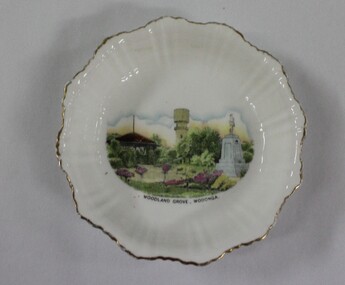
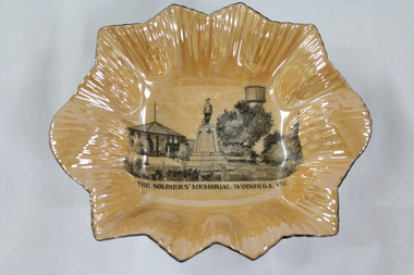 Wodonga & District Historical Society Inc
Memorabilia - Woodland Grove Souvenir dish made by RKG under licence for Royal Sydney China, Czechoslovakia, c. 1920, RKG, c. 1921 - 1938
A wide range of souvenirs have been produced to commemorate Wodonga and its landmarks over time. These items document key changes in Wodonga and its heritage. The producers mark on the plate was used by the company RKG Czechoslovakia between 1921 and 1938 This plate depicts three key landmarks in Wodonga. THE SOLDIERS' MEMORIAL in Wodonga was unveiled on Tuesday 18th November 1924. It was designed by Messrs. Hosken & Co., of Hawthorn, Victoria. The monument is all of Australian workmanship. The pedestal is made of Harcourt granite, 9ft x 9ft at the base, and rising in seven courses to a height of 10ft 2in. The emblems (rising sun and wreath) are of bronze, and the lettering of the inscription and names of fallen soldiers are in raised lead letters. Originally the Memorial was completed with a full life size, 6ft in height, sculpture of an Australian soldier in Sicilian marble. The memorial bore the inscriptions: ERECTED BY THE RESIDENTS OF WODONGA AND DISTRICT IN MEMORY of the Men of this Town and District who fell in the Great War, 1914-1919, Also in grateful recognition of the men who served and returned. “Lest We Forget.” In 1982, due to frequent vandalism and high cost of materials to repair, the soldier statue was removed and later installed at the RSL Rooms. THE WATER TOWER is a major landmark of High Street, Wodonga. It began operation from 1924 until it ceased operation in 1952. It stood unused for a decade until the lower section was modified and put to use as “ The Tower’s Cobbler’s Inn” in 1962. In 1972 Wodonga City Council proposed to demolish the Tower. Their suggestion received an unfavorable response from the city’s citizens, so the Tower still stands today. THE BAND ROTUNDA was officially opened on Sunday 5th September 1920 at the naming of the triangular reserve at the corner of High and Hovell Streets as Woodland Grove. The Wodonga Band gave a public performance on this occasion. The tri-coloured ribbon, which stretched across the entrance to the Rotunda was cut by Mrs R.H Murphy, daughter of Mr. John Woodland, secretary of the Wodonga Shire Council for 35 years, after whom the area was named. The rotunda has since been moved to Martin Park, Wodonga. Small china pieces carrying scenic views of holiday destinations were a popular kind of souvenir during much of the 20th century. These items have local and social significance as they reflect the landmarks or local features valued by the community over time. An apricot irregular shaped dish made from lustre ware with a drawing of the Wodonga Soldiers Memorial, Water Tower and Rotunda. The manufacturer's mark is imprinted on the base. Text under the image says 'THE SOLDIERS' MEMORIAL. WODONGA. VICManufacturer's trademark printed on base, in orange paint, in a circular formation 'ROYAL SYDNEY CHINA / MADE IN / CZECHOSLOVAKIA', within circular formation '(crown) / RK / G' ('RK / G' within circle with handles).porcelain, wodonga, royal sydney china, soldier memorial, wodonga souvenirs -
 Glen Eira Historical Society
Article - CAULFIELD LITTLE ATHLETICS
... Parks ...This file contains 5 items: 1/1Newspaper article from the Standard Times, dated 03/11/1971, describing the results from the Saturday athletics competitions held by Caulfield Little Athletics Association. Results range from under eights age group to under fifteens age group both girls and boys. 2/1 article from the Caulfield/Port Phillip Leader on the success of the Caulfield Little Athletics Club at the Little Athletics State Track and Field Championship, dated 29/03/2011. 3/1 article from the Caulfield/Port Phillip Leader, dated 11/10/2011, describing the ‘Bring a Friend Day’ event at Duncan Mackinnon Reserve, and promoting the Caulfield Little Athletics Association. 4/1 article from the Glen Eira/Port Phillip Leader on the success of the Caulfield Little Athletics Club at the Southern Metro Region Championship, dated 12/03/2013. 5/I article from the Glen Eira/Port Phillip Leader on Caulfield Little Athletics Clubs success at the Little Athletics Southern Metro Region Cross Country and Walks Challenge, dated 30/07/2013.foley roy, arden cr., arden mrs, gunn e cr., walters r cr., gunn e mrs., blair cr., poolan g cr., foley kath, russell geoff, caulfield, caulfield south, sports clubs, ladson mandy, sanders neil, ‘bring a friend day’, duncan mackinnon reserve, caulfield little athletics centre, harper russell, bendigo bank murrumbeena, sporting clubs, caulfield little athletics, sports, recreations, competitions, entertainment, sports grounds, parks, reserves, leisure, cultural events, cultural activities, athletics, ovals, clubs, associations, thompson riley, montag jemima, watson sasha, mouratch daniel, montag piper, brammer bridget, nakase taishi, macdonald georgie, mckenzie charlotte, edwards nicholas, kolokythas keelan, kelart oliver, davis nicola, o’brien genevieve, montag andie, o’connor aisling, catalano maggie, jayesena dinesh, glew liam, menara lachlan, meysztavicz james, miller samantha, williams elinor, pickering jasper, caulfield/port phillip leader, glen eira/port phillip leader, standard times -
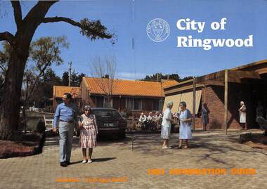 Ringwood and District Historical Society
Booklet, City of Ringwood 1985 Information Guide, 1985
Community information booklet issued by City of Ringwood for 1985 - covering the facilities and activities of the Ringwood Council and other local organisations and associations. Cover photograph: Lionsbrae - Frail Aged Hostel.CONTENTS: (page no.) By-Laws/Traffic Regs. 35 Chief Executive 10 Children's Service 12, 13 & 40 Churches 41 City Map 32 & 33 Committees of Council 7 Community Services 38 Community Services Officer 43 Council Finances 24 Councillors 4 & 5 Council Meeting Dates 6 Council Representatives 8 Cultural Centre 23 Disabled Persons Facilities 44 Eastern Corridor 18 East Ringwood Shopping Centre 22 Emergency Telephone Nos. 63 Garbage Collection 20 Golf Course 15 Health 26 Historical Research Croup 47 Home Help 30 Hospitals 48 Immunisations 27 Incinerators 21 Infant Welfare Centres49 J.P.'s and Commissioners 37 Library 28 & 29 Lionsbrae 17 Management Executive 11 Mayoral Message – Cr. R. Gardini, J.P. 3 Meals on Wheels 34 North Ringwood Senior Citizens 16 Opportunity Shops 53 Parks and Reserves 53 Parliamentary Representatives 9 Playgroups 55 Pre-schools 56 Public Toilets 56 Rates 25 Ringwood Croydon Advisory Service 37 Schools 58 Senior Citizens Centres 60 Swimming Pool 14 Unemployment 62 Victoria's 150th Anniversary 36 Works Programme 18 & 19 Youth Outreach Worker 62 rinx -
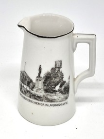 Wodonga & District Historical Society Inc
Souvenir - Souvenir Cream Jug - Soldiers' Memorial, Wodonga, 1921 - 1938
This item is from a collection donated by descendants of John Francis Turner of Wodonga. A wide range of small china pieces carrying scenic views of holiday destinations or key locations were a popular kind of souvenir during much of the 20th century. Several different items have been produced to commemorate Wodonga and its landmarks over time. These items document key changes in Wodonga and its heritage. This plate depicts three key landmarks in Wodonga. THE SOLDIERS' MEMORIAL in Wodonga was unveiled on Tuesday 18th November 1924. It was designed by Messrs. Hosken & Co., of Hawthorn, Victoria. The monument is all of Australian workmanship. The pedestal is made of Harcourt granite, 9ft x 9ft at the base, and rising in seven courses to a height of 10ft 2in. The emblems (rising sun and wreath) are of bronze, and the lettering of the inscription and names of fallen soldiers are in raised lead letters. Originally the Memorial was completed with a full life size, 6ft in height, sculpture of an Australian soldier in Sicilian marble. The memorial bore the inscriptions: ERECTED BY THE RESIDENTS OF WODONGA AND DISTRICT IN MEMORY of the Men of this Town and District who fell in the Great War, 1914-1919, Also in grateful recognition of the men who served and returned. “Lest We Forget.” In 1982, due to frequent vandalism and high cost of materials to repair, the soldier statue was removed and later installed at the RSL Rooms. THE WATER TOWER is a major landmark of High Street, Wodonga. It began operation from January 1924 until it ceased operation in 1952. It stood unused for a decade until the lower section was modified and put to use as “ The Tower’s Cobbler’s Inn” in 1962. In 1972 Wodonga City Council proposed to demolish the Tower. Their suggestion received an unfavorable response from the city’s citizens, so the Tower still stands today. THE BAND ROTUNDA was officially opened on Sunday 5th September 1920 at the naming of the triangular reserve at the corner of High and Hovell Streets as Woodland Grove. The Wodonga Band gave a public performance on this occasion. The tri-coloured ribbon, which stretched across the entrance to the Rotunda was cut by Mrs R.H Murphy, daughter of Mr. John Woodland, secretary of the Wodonga Shire Council for 35 years, after whom the area was named. The rotunda has since been moved to Martin Park, Wodonga.This item comes from a collection used by a prominent citizen of Wodonga. It is also an excellent example of souvenir items created featuring landmarks to represent the city of Wodonga.White glazed porcelain cream jug with grooved square handle. The base is unglazed. The rim and outer face of the handle are outlined in black paint. On one side of the jug is a black transfer print of a the Wodonga Soldiers' Memorial. Text underneath the scene reads "THE SOLDIERS' MEMORIAL, WODONGA, VIC."'. The manufacturer's trademark is printed on the base of the jug. RKG stood for Rudolf Kampf of Grunlas. The mark with the initials under the crown was used from 1921 to 1938.Beneath the image: 'THE SOLDIERS' MEMORIAL WODONGA VIC" Under the jug Manufacturer's trademark printed in orange paint, in a circular formation '(crown) / RK / G' ('RK / G' within circle with handles) above the words "Made in Czechoslovakia"domestic items, souvenir wodonga, woodland grove wodonga -
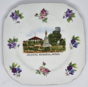 Wodonga & District Historical Society Inc
Souvenir - China Souvenir Plate Soldiers' Memorial. Wodonga, Victoria China, c1924 - 1939
This item is from a collection donated by descendants of John Francis Turner of Wodonga. A wide range of small china pieces carrying scenic views of holiday destinations or key locations were a popular kind of souvenir during much of the 20th century. Several different items have been produced to commemorate Wodonga and its landmarks over time. These items document key changes in Wodonga and its heritage. This plate depicts three key landmarks in Wodonga. THE SOLDIERS' MEMORIAL in Wodonga was unveiled on Tuesday 18th November 1924. It was designed by Messrs. Hosken & Co., of Hawthorn, Victoria. The monument is all of Australian workmanship. The pedestal is made of Harcourt granite, 9ft x 9ft at the base, and rising in seven courses to a height of 10ft 2in. The emblems (rising sun and wreath) are of bronze, and the lettering of the inscription and names of fallen soldiers are in raised lead letters. Originally the Memorial was completed with a full life size, 6ft in height, sculpture of an Australian soldier in Sicilian marble. The memorial bore the inscriptions: ERECTED BY THE RESIDENTS OF WODONGA AND DISTRICT IN MEMORY of the Men of this Town and District who fell in the Great War, 1914-1919, Also in grateful recognition of the men who served and returned. “Lest We Forget.” In 1982, due to frequent vandalism and high cost of materials to repair, the soldier statue was removed and later installed at the RSL Rooms. THE WATER TOWER is a major landmark of High Street, Wodonga. It began operation from January 1924 until it ceased operation in 1952. It stood unused for a decade until the lower section was modified and put to use as “ The Tower’s Cobbler’s Inn” in 1962. In 1972 Wodonga City Council proposed to demolish the Tower. Their suggestion received an unfavorable response from the city’s citizens, so the Tower still stands today. THE BAND ROTUNDA was officially opened on Sunday 5th September 1920 at the naming of the triangular reserve at the corner of High and Hovell Streets as Woodland Grove. The Wodonga Band gave a public performance on this occasion. The tri-coloured ribbon, which stretched across the entrance to the Rotunda was cut by Mrs R.H Murphy, daughter of Mr. John Woodland, secretary of the Wodonga Shire Council for 35 years, after whom the area was named. The rotunda has since been moved to Martin Park, Wodonga.This item comes from a collection used by a prominent citizen of Wodonga. It is also an excellent example of souvenir items created featuring landmarks to represent the city of Wodonga.A china plate depicting the Soldiers' Memorial Wodonga. The central coloured image is surrounded by a 8 representations of a variety of flowers and a silver edge trim. The makers mark underneath the dish was used between 1918 - 1939 so assists in establishing provenance of the irem.Beneath image: "SOLDIERS' MEMORIAL WODONGA On back of dish, Beneath a crown " VICTORIA CHINA CZECHOSLAVAKIA"victoria china, souvenir wodonga, wodonga soldiers memorial, woodland grove wodonga -
 Wodonga & District Historical Society Inc
Memorabilia - China Souvenir Bowl Woodland Grove Wodonga, c. 1920 - 1940
A wide range of small china pieces carrying scenic views of holiday destinations or key locations were a popular kind of souvenir during much of the 20th century. Several different items have been produced to commemorate Wodonga and its landmarks over time. These items document key changes in Wodonga and its heritage. This plate depicts three key landmarks in Wodonga. THE SOLDIERS' MEMORIAL in Wodonga was unveiled on Tuesday 18th November 1924. It was designed by Messrs. Hosken & Co., of Hawthorn, Victoria. The monument is all of Australian workmanship. The pedestal is made of Harcourt granite, 9ft x 9ft at the base, and rising in seven courses to a height of 10ft 2in. The emblems (rising sun and wreath) are of bronze, and the lettering of the inscription and names of fallen soldiers are in raised lead letters. Originally the Memorial was completed with a full life size, 6ft in height, sculpture of an Australian soldier in Sicilian marble. The memorial bore the inscriptions: ERECTED BY THE RESIDENTS OF WODONGA AND DISTRICT IN MEMORY of the Men of this Town and District who fell in the Great War, 1914-1919, Also in grateful recognition of the men who served and returned. “Lest We Forget.” In 1982, due to frequent vandalism and high cost of materials to repair, the soldier statue was removed and later installed at the RSL Rooms. THE WATER TOWER is a major landmark of High Street, Wodonga. It began operation from 1924 until it ceased operation in 1952. It stood unused for a decade until the lower section was modified and put to use as “ The Tower’s Cobbler’s Inn” in 1962. In 1972 Wodonga City Council proposed to demolish the Tower. Their suggestion received an unfavorable response from the city’s citizens, so the Tower still stands today. THE BAND ROTUNDA was officially opened on Sunday 5th September 1920 at the naming of the triangular reserve at the corner of High and Hovell Streets as Woodland Grove. The Wodonga Band gave a public performance on this occasion. The tri-coloured ribbon, which stretched across the entrance to the Rotunda was cut by Mrs R.H Murphy, daughter of Mr. John Woodland, secretary of the Wodonga Shire Council for 35 years, after whom the area was named. The rotunda has since been moved to Martin Park, Wodonga. This item has local historic and social significance as it depicts which features of the city the community valued in the past. It has artistic significance as an example of the kinds of souvenirs used widely across Australia to represent communities and the landscape.A white glazed china souvenir bowl. Frilled edge. Includes a painted representation of Woodland Grove, Wodonga, VictoriaBeneath the painted central image "WOODLAND GROVE, WODONGAwodonga, souvenirs, woodland grove, ceramics -
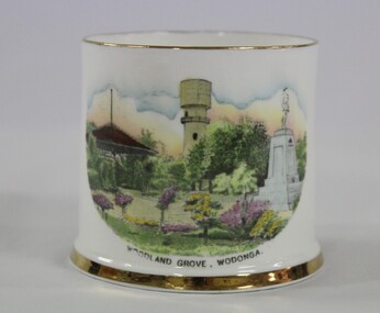 Wodonga & District Historical Society Inc
Memorabilia - China Souvenir Cup Woodland Grove Wodonga, c. 1925 - 1940
A wide range of small china pieces carrying scenic views of holiday destinations or key locations were a popular kind of souvenir during much of the 20th century. Several different items have been produced to commemorate Wodonga and its landmarks over time. These items document key changes in Wodonga and its heritage. This cup depicts three key landmarks in Wodonga. THE SOLDIERS' MEMORIAL in Wodonga was unveiled on Tuesday 18th November 1924. It was designed by Messrs. Hosken & Co., of Hawthorn, Victoria. The monument is all of Australian workmanship. The pedestal is made of Harcourt granite, 9ft x 9ft at the base, and rising in seven courses to a height of 10ft 2in. The emblems (rising sun and wreath) are of bronze, and the lettering of the inscription and names of fallen soldiers are in raised lead letters. Originally the Memorial was completed with a full life size, 6ft in height, sculpture of an Australian soldier in Sicilian marble. The memorial bore the inscriptions: ERECTED BY THE RESIDENTS OF WODONGA AND DISTRICT IN MEMORY of the Men of this Town and District who fell in the Great War, 1914-1919, Also in grateful recognition of the men who served and returned. “Lest We Forget.” In 1982, due to frequent vandalism and high cost of materials to repair, the soldier statue was removed and later installed at the RSL Rooms. THE WATER TOWER is a major landmark of High Street, Wodonga. It began operation from 1924 until it ceased operation in 1952. It stood unused for a decade until the lower section was modified and put to use as “ The Tower’s Cobbler’s Inn” in 1962. In 1972 Wodonga City Council proposed to demolish the Tower. Their suggestion received an unfavorable response from the city’s citizens, so the Tower still stands today. THE BAND ROTUNDA was officially opened on Sunday 5th September 1920 at the naming of the triangular reserve at the corner of High and Hovell Streets as Woodland Grove. The Wodonga Band gave a public performance on this occasion. The tri-coloured ribbon, which stretched across the entrance to the Rotunda was cut by Mrs R.H Murphy, daughter of Mr. John Woodland, secretary of the Wodonga Shire Council for 35 years, after whom the area was named. The rotunda has since been moved to Martin Park, Wodonga. This item has local historic and social significance as it depicts which features of the city the community valued in the past. It has artistic significance as an example of the kinds of souvenirs used widely across Australia to represent communities and the landscape.A white souvenir cup made from china with a water colour image of Woodland Grove, Wodonga which incorporates the Soldier Memorial, Water Tower and the Rotunda."WOODLAND GROVE, WODONGA."souvenirs, wodonga, woodland grove, soldiers memorial, wodonga landmarks -
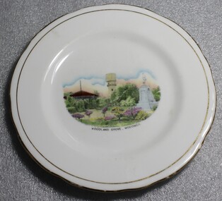 Wodonga & District Historical Society Inc
Memorabilia - Souvenir Plate Woodland Grove, Wodonga, Victoria, Royal Stafford China
A wide range of small china pieces carrying scenic views of holiday destinations or key locations were a popular kind of souvenir during much of the 20th century. Several different items have been produced to commemorate Wodonga and its landmarks over time. These items document key changes in Wodonga and its heritage. This plate depicts three key landmarks in Wodonga. THE SOLDIERS' MEMORIAL in Wodonga was unveiled on Tuesday 18th November 1924. It was designed by Messrs. Hosken & Co., of Hawthorn, Victoria. The monument is all of Australian workmanship. The pedestal is made of Harcourt granite, 9ft x 9ft at the base, and rising in seven courses to a height of 10ft 2in. The emblems (rising sun and wreath) are of bronze, and the lettering of the inscription and names of fallen soldiers are in raised lead letters. Originally the Memorial was completed with a full life size, 6ft in height, sculpture of an Australian soldier in Sicilian marble. The memorial bore the inscriptions: ERECTED BY THE RESIDENTS OF WODONGA AND DISTRICT IN MEMORY of the Men of this Town and District who fell in the Great War, 1914-1919, Also in grateful recognition of the men who served and returned. “Lest We Forget.” In 1982, due to frequent vandalism and high cost of materials to repair, the soldier statue was removed and later installed at the RSL Rooms. THE WATER TOWER is a major landmark of High Street, Wodonga. It began operation from 1924 until it ceased operation in 1952. It stood unused for a decade until the lower section was modified and put to use as “ The Tower’s Cobbler’s Inn” in 1962. In 1972 Wodonga City Council proposed to demolish the Tower. Their suggestion received an unfavorable response from the city’s citizens, so the Tower still stands today. THE BAND ROTUNDA was officially opened on Sunday 5th September 1920 at the naming of the triangular reserve at the corner of High and Hovell Streets as Woodland Grove. The Wodonga Band gave a public performance on this occasion. The tri-coloured ribbon, which stretched across the entrance to the Rotunda was cut by Mrs R.H Murphy, daughter of Mr. John Woodland, secretary of the Wodonga Shire Council for 35 years, after whom the area was named. The rotunda has since been moved to Martin Park, Wodonga. This bone china plate features an image of Woodland Grove. Wodonga, Victoria. The image incorporates landmarks in Woodland Grove, including the Soldiers' Memorial, the Rotunda and the Water Tower. There is a makers' mark imprinted on the underside of the plate."ROYAL STAFFORD/BONE CHINA/ MADE IN ENGLAND/ 423" . A crown is in the centre of the textmemorabilia, woodland grove, wodonga victoria -
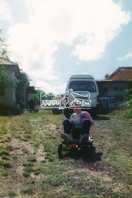
 Eltham District Historical Society Inc
Photograph, Upper Yarra Dam, Spring Tour, 22 Oct 1995, 22/10/1995
EXPLORING THE UPPER YARRA (Newsletter No. 105, November 1995, by Bettina Woodburn) We enjoyed the Spring Excursion, this year "Exploring the Upper Yarra" - in spite of the constant rain and the countryside under the cloud cover, especially in the valleys, being mainly shiny shades of green. The occasional fields of buttercups, clumps of arum lilies and splendid rhododendron and other flowering bushes became very special. The Cobb and Co coach was warm and a cosy retreat as we zig-zagged on the highways and byways to glimpse the Yarra River, upstream and down, its secret places, and particularly the many bridges. Russell excelled as 'Poet Laureate', reading from Dacre Smyth's book. This 1979 publication includes paintings of all the bridges along the river with poems and brief descriptions of each one. Some of the bridges are in out of the way places and are not very well known. We looked forward to hearing the poetry as much as seeing the ' constructions'…Big Pat (was he short or tall, lean or fat? He did win the two hundred pound reward for discovering gold and had the creek named after him), about the 'Eddies'?, and the disliked 'meccano' bridge in Warburton, etc. etc. The hot roast lunch in the old Reefton Hotel was also most welcome. It was easy to imagine it peopled by miners and early settlers. Starting by crossing the new (1974) concrete bridge at Warrandyte we headed through Wonga Park with views to the Christmas Hills and to the escarpment of the Yering Gorge, which causes flood waters to back up through the Yarra Glen plain, so avoiding disasters downstream. At the end of a long driveway we found the wooden, privately owned Henley Bridge (1935 after the 1934 floods). This facilitates access to different parts of Henley Farm and to Lilydale. Everard Park, named after Blanche Shallard's father, a State Member for 17 years, below the Highway Yarra crossing was in need of care. It is 10 miles from Yarra Glen by road but, as "Yarra Marra” canoeists well know, 32 winding miles down by water. After more delightful countryside scenes we joined the Warburton Highway at Woori Yallock. From the old Railway Station at Launching Place the Centennial Trail for walkers, cyclists and ' horse riders has replaced the rails. The line from Lilydale was opened in 1901, and the last diesel freight train ran to Warburton in 1965. It continued to rain as we had morning tea in Warburton in a shelter between footbridges. From here we continued upstream past the Bridge to O'Shannasy Lodge and Reservoir, Starvation Creek, and the Peninsular tunnel (miners dug it as at Pound Bend) which we visited (scrambling down those steps!) on our return after lunch. Our furthermost point was the Upper Yarra Dam Reserve (and vast catchment area). Finished in 1957 after ten years work and 100 years after Yan Yean, it supplies much of Melbourne's water. After crossing the 30m Launching Place Bridge to the Eltham side of the Yarra and Healesville, we saw in the distance the Yarra Glen Timber Trestle Bridge over the river flats "the longest for years in the land it was said!" Harry's dream of "better weather over the Divide" unfortunately didn't come true, but I'm sure we 36 members will retain happy memories of a day that was wet and green and filled with Bridges. Bettina Woodburn - October 1995 Record of the Society's history of activities - Spring 1995 excursionColour photographshire of eltham historical society, activities, upper yarra dam, henley bridge -
 Eltham District Historical Society Inc
Photograph, Upper Yarra Dam, Spring Tour, 22 Oct 1995, 22/10/1995
EXPLORING THE UPPER YARRA (Newsletter No. 105, November 1995, by Bettina Woodburn) We enjoyed the Spring Excursion, this year "Exploring the Upper Yarra" - in spite of the constant rain and the countryside under the cloud cover, especially in the valleys, being mainly shiny shades of green. The occasional fields of buttercups, clumps of arum lilies and splendid rhododendron and other flowering bushes became very special. The Cobb and Co coach was warm and a cosy retreat as we zig-zagged on the highways and byways to glimpse the Yarra River, upstream and down, its secret places, and particularly the many bridges. Russell excelled as 'Poet Laureate', reading from Dacre Smyth's book. This 1979 publication includes paintings of all the bridges along the river with poems and brief descriptions of each one. Some of the bridges are in out of the way places and are not very well known. We looked forward to hearing the poetry as much as seeing the ' constructions'…Big Pat (was he short or tall, lean or fat? He did win the two hundred pound reward for discovering gold and had the creek named after him), about the 'Eddies'?, and the disliked 'meccano' bridge in Warburton, etc. etc. The hot roast lunch in the old Reefton Hotel was also most welcome. It was easy to imagine it peopled by miners and early settlers. Starting by crossing the new (1974) concrete bridge at Warrandyte we headed through Wonga Park with views to the Christmas Hills and to the escarpment of the Yering Gorge, which causes flood waters to back up through the Yarra Glen plain, so avoiding disasters downstream. At the end of a long driveway we found the wooden, privately owned Henley Bridge (1935 after the 1934 floods). This facilitates access to different parts of Henley Farm and to Lilydale. Everard Park, named after Blanche Shallard's father, a State Member for 17 years, below the Highway Yarra crossing was in need of care. It is 10 miles from Yarra Glen by road but, as "Yarra Marra” canoeists well know, 32 winding miles down by water. After more delightful countryside scenes we joined the Warburton Highway at Woori Yallock. From the old Railway Station at Launching Place the Centennial Trail for walkers, cyclists and ' horse riders has replaced the rails. The line from Lilydale was opened in 1901, and the last diesel freight train ran to Warburton in 1965. It continued to rain as we had morning tea in Warburton in a shelter between footbridges. From here we continued upstream past the Bridge to O'Shannasy Lodge and Reservoir, Starvation Creek, and the Peninsular tunnel (miners dug it as at Pound Bend) which we visited (scrambling down those steps!) on our return after lunch. Our furthermost point was the Upper Yarra Dam Reserve (and vast catchment area). Finished in 1957 after ten years work and 100 years after Yan Yean, it supplies much of Melbourne's water. After crossing the 30m Launching Place Bridge to the Eltham side of the Yarra and Healesville, we saw in the distance the Yarra Glen Timber Trestle Bridge over the river flats "the longest for years in the land it was said!" Harry's dream of "better weather over the Divide" unfortunately didn't come true, but I'm sure we 36 members will retain happy memories of a day that was wet and green and filled with Bridges. Bettina Woodburn - October 1995 Record of the Society's history of activities - Spring 1995 excursionRoll of 35mm colour negative film, 3 stripsKodak Gold 200-4shire of eltham historical society, activities, upper yarra dam, henley bridge -
 Eltham District Historical Society Inc
Photograph, Upper Yarra Dam, Spring Tour, 22 Oct 1995, 22/10/1995
EXPLORING THE UPPER YARRA (Newsletter No. 105, November 1995, by Bettina Woodburn) We enjoyed the Spring Excursion, this year "Exploring the Upper Yarra" - in spite of the constant rain and the countryside under the cloud cover, especially in the valleys, being mainly shiny shades of green. The occasional fields of buttercups, clumps of arum lilies and splendid rhododendron and other flowering bushes became very special. The Cobb and Co coach was warm and a cosy retreat as we zig-zagged on the highways and byways to glimpse the Yarra River, upstream and down, its secret places, and particularly the many bridges. Russell excelled as 'Poet Laureate', reading from Dacre Smyth's book. This 1979 publication includes paintings of all the bridges along the river with poems and brief descriptions of each one. Some of the bridges are in out of the way places and are not very well known. We looked forward to hearing the poetry as much as seeing the ' constructions'…Big Pat (was he short or tall, lean or fat? He did win the two hundred pound reward for discovering gold and had the creek named after him), about the 'Eddies'?, and the disliked 'meccano' bridge in Warburton, etc. etc. The hot roast lunch in the old Reefton Hotel was also most welcome. It was easy to imagine it peopled by miners and early settlers. Starting by crossing the new (1974) concrete bridge at Warrandyte we headed through Wonga Park with views to the Christmas Hills and to the escarpment of the Yering Gorge, which causes flood waters to back up through the Yarra Glen plain, so avoiding disasters downstream. At the end of a long driveway we found the wooden, privately owned Henley Bridge (1935 after the 1934 floods). This facilitates access to different parts of Henley Farm and to Lilydale. Everard Park, named after Blanche Shallard's father, a State Member for 17 years, below the Highway Yarra crossing was in need of care. It is 10 miles from Yarra Glen by road but, as "Yarra Marra” canoeists well know, 32 winding miles down by water. After more delightful countryside scenes we joined the Warburton Highway at Woori Yallock. From the old Railway Station at Launching Place the Centennial Trail for walkers, cyclists and ' horse riders has replaced the rails. The line from Lilydale was opened in 1901, and the last diesel freight train ran to Warburton in 1965. It continued to rain as we had morning tea in Warburton in a shelter between footbridges. From here we continued upstream past the Bridge to O'Shannasy Lodge and Reservoir, Starvation Creek, and the Peninsular tunnel (miners dug it as at Pound Bend) which we visited (scrambling down those steps!) on our return after lunch. Our furthermost point was the Upper Yarra Dam Reserve (and vast catchment area). Finished in 1957 after ten years work and 100 years after Yan Yean, it supplies much of Melbourne's water. After crossing the 30m Launching Place Bridge to the Eltham side of the Yarra and Healesville, we saw in the distance the Yarra Glen Timber Trestle Bridge over the river flats "the longest for years in the land it was said!" Harry's dream of "better weather over the Divide" unfortunately didn't come true, but I'm sure we 36 members will retain happy memories of a day that was wet and green and filled with Bridges. Bettina Woodburn - October 1995 Record of the Society's history of activities - Spring 1995 excursionRoll of 35mm colour negative film, 2 stripsKodak Gold 100-4shire of eltham historical society, activities, upper yarra dam, henley bridge -
 Eltham District Historical Society Inc
Photograph, Upper Yarra Dam, Spring Tour, 22 Oct 1995, 22/10/1995
EXPLORING THE UPPER YARRA (Newsletter No. 105, November 1995, by Bettina Woodburn) We enjoyed the Spring Excursion, this year "Exploring the Upper Yarra" - in spite of the constant rain and the countryside under the cloud cover, especially in the valleys, being mainly shiny shades of green. The occasional fields of buttercups, clumps of arum lilies and splendid rhododendron and other flowering bushes became very special. The Cobb and Co coach was warm and a cosy retreat as we zig-zagged on the highways and byways to glimpse the Yarra River, upstream and down, its secret places, and particularly the many bridges. Russell excelled as 'Poet Laureate', reading from Dacre Smyth's book. This 1979 publication includes paintings of all the bridges along the river with poems and brief descriptions of each one. Some of the bridges are in out of the way places and are not very well known. We looked forward to hearing the poetry as much as seeing the ' constructions'…Big Pat (was he short or tall, lean or fat? He did win the two hundred pound reward for discovering gold and had the creek named after him), about the 'Eddies'?, and the disliked 'meccano' bridge in Warburton, etc. etc. The hot roast lunch in the old Reefton Hotel was also most welcome. It was easy to imagine it peopled by miners and early settlers. Starting by crossing the new (1974) concrete bridge at Warrandyte we headed through Wonga Park with views to the Christmas Hills and to the escarpment of the Yering Gorge, which causes flood waters to back up through the Yarra Glen plain, so avoiding disasters downstream. At the end of a long driveway we found the wooden, privately owned Henley Bridge (1935 after the 1934 floods). This facilitates access to different parts of Henley Farm and to Lilydale. Everard Park, named after Blanche Shallard's father, a State Member for 17 years, below the Highway Yarra crossing was in need of care. It is 10 miles from Yarra Glen by road but, as "Yarra Marra” canoeists well know, 32 winding miles down by water. After more delightful countryside scenes we joined the Warburton Highway at Woori Yallock. From the old Railway Station at Launching Place the Centennial Trail for walkers, cyclists and ' horse riders has replaced the rails. The line from Lilydale was opened in 1901, and the last diesel freight train ran to Warburton in 1965. It continued to rain as we had morning tea in Warburton in a shelter between footbridges. From here we continued upstream past the Bridge to O'Shannasy Lodge and Reservoir, Starvation Creek, and the Peninsular tunnel (miners dug it as at Pound Bend) which we visited (scrambling down those steps!) on our return after lunch. Our furthermost point was the Upper Yarra Dam Reserve (and vast catchment area). Finished in 1957 after ten years work and 100 years after Yan Yean, it supplies much of Melbourne's water. After crossing the 30m Launching Place Bridge to the Eltham side of the Yarra and Healesville, we saw in the distance the Yarra Glen Timber Trestle Bridge over the river flats "the longest for years in the land it was said!" Harry's dream of "better weather over the Divide" unfortunately didn't come true, but I'm sure we 36 members will retain happy memories of a day that was wet and green and filled with Bridges. Bettina Woodburn - October 1995 Record of the Society's history of activities - Spring 1995 excursionRoll of 35mm colour negative film, 4 of 5 stripsKodak Gold 400-5shire of eltham historical society, activities, upper yarra dam, henley bridge -
 Eltham District Historical Society Inc
Photograph, Upper Yarra Dam, Spring Tour, 22 Oct 1995, 22/10/1995
EXPLORING THE UPPER YARRA (Newsletter No. 105, November 1995, by Bettina Woodburn) We enjoyed the Spring Excursion, this year "Exploring the Upper Yarra" - in spite of the constant rain and the countryside under the cloud cover, especially in the valleys, being mainly shiny shades of green. The occasional fields of buttercups, clumps of arum lilies and splendid rhododendron and other flowering bushes became very special. The Cobb and Co coach was warm and a cosy retreat as we zig-zagged on the highways and byways to glimpse the Yarra River, upstream and down, its secret places, and particularly the many bridges. Russell excelled as 'Poet Laureate', reading from Dacre Smyth's book. This 1979 publication includes paintings of all the bridges along the river with poems and brief descriptions of each one. Some of the bridges are in out of the way places and are not very well known. We looked forward to hearing the poetry as much as seeing the ' constructions'…Big Pat (was he short or tall, lean or fat? He did win the two hundred pound reward for discovering gold and had the creek named after him), about the 'Eddies'?, and the disliked 'meccano' bridge in Warburton, etc. etc. The hot roast lunch in the old Reefton Hotel was also most welcome. It was easy to imagine it peopled by miners and early settlers. Starting by crossing the new (1974) concrete bridge at Warrandyte we headed through Wonga Park with views to the Christmas Hills and to the escarpment of the Yering Gorge, which causes flood waters to back up through the Yarra Glen plain, so avoiding disasters downstream. At the end of a long driveway we found the wooden, privately owned Henley Bridge (1935 after the 1934 floods). This facilitates access to different parts of Henley Farm and to Lilydale. Everard Park, named after Blanche Shallard's father, a State Member for 17 years, below the Highway Yarra crossing was in need of care. It is 10 miles from Yarra Glen by road but, as "Yarra Marra” canoeists well know, 32 winding miles down by water. After more delightful countryside scenes we joined the Warburton Highway at Woori Yallock. From the old Railway Station at Launching Place the Centennial Trail for walkers, cyclists and ' horse riders has replaced the rails. The line from Lilydale was opened in 1901, and the last diesel freight train ran to Warburton in 1965. It continued to rain as we had morning tea in Warburton in a shelter between footbridges. From here we continued upstream past the Bridge to O'Shannasy Lodge and Reservoir, Starvation Creek, and the Peninsular tunnel (miners dug it as at Pound Bend) which we visited (scrambling down those steps!) on our return after lunch. Our furthermost point was the Upper Yarra Dam Reserve (and vast catchment area). Finished in 1957 after ten years work and 100 years after Yan Yean, it supplies much of Melbourne's water. After crossing the 30m Launching Place Bridge to the Eltham side of the Yarra and Healesville, we saw in the distance the Yarra Glen Timber Trestle Bridge over the river flats "the longest for years in the land it was said!" Harry's dream of "better weather over the Divide" unfortunately didn't come true, but I'm sure we 36 members will retain happy memories of a day that was wet and green and filled with Bridges. Bettina Woodburn - October 1995 Record of the Society's history of activities - Spring 1995 excursionRoll of 35mm colour negative film, 4 of 5 stripsKodak Gold 400-5shire of eltham historical society, activities, upper yarra dam, henley bridge