Showing 9791 items matching " plenty road"
-
 Eltham District Historical Society Inc
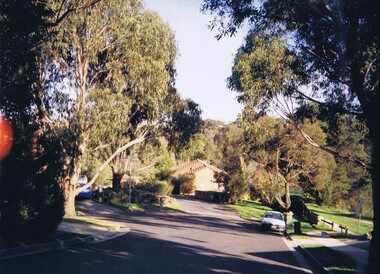
Slide, Post drainage repairs on Bonds Road near Martin property and Montpelier Drive, Lower Plenty, c.July 1972, 1972
... in Bonds Road, Lower Plenty outside the Martin property opposite... in Bonds Road, Lower Plenty outside the Martin property opposite ...Water drainage work undertaken by Eltham Shire Council in Bonds Road, Lower Plenty outside the Martin property opposite Montpelier Drive, July 1972 35 mm colour positive transparency Mount - Agfacolor Service (Blue)Bonds Road (Martin property) 12.10 pm 18.7.72bonds road, drainage works, eltham shire council, infrastructure, lower plenty, martin property, montpelier drive -
 Greensborough Historical Society
Photograph - Digital image, Ivy Barnett, 1945c
... 122 main road lower plenty...Ivy Barnett taken at 122 Main Road Lower Plenty... Plenty Lower Plenty melbourne Ivy Barnett taken at 122 Main Road ...Ivy Barnett taken at 122 Main Road Lower Plenty. Photographs from the collection of Peter Blackbourn, a descendant of the Chapman Stock family. Annotations to photos by Peter Blackbourn.Digital copy of black and white photograph.peter blackbourn, ivy barnett, 122 main road lower plenty -
 Greensborough Historical Society
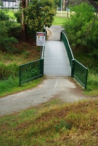
Photograph - Digital Image, Marilyn Smith, Willinda Park bridge to Simms Road, 06/11/2017
... . It has an athletics track and field and is adjacent to the Plenty... across the Plenty River to Simms Road Reserve. willinda park ...Willinda Park is situated in Beatrix Street Greensborough. It has an athletics track and field and is adjacent to the Plenty River. This photograph shows the footbridge across the Plenty River to Simms Road Reserve.Digital copy of colour photographwillinda park, beatrix street greensborough, athletics, plenty river -
 Eltham District Historical Society Inc
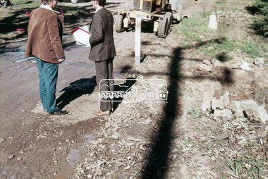
Slide, Looking south along Bonds Road towards intersection of Montpelier Drive, Lower Plenty, 18 July 1972, 1972
... in Bonds Road, Lower Plenty outside the Martin property opposite... in Bonds Road, Lower Plenty outside the Martin property opposite ...Water drainage work undertaken by Eltham Shire Council in Bonds Road, Lower Plenty outside the Martin property opposite Montpelier Drive, July 1972 Note blocked table drains.35 mm colour positive transparency Mount - Agfacolor Service (Blue)Bonds Road (Martin property) 12.10 pm 18.7.72bonds road, drainage works, eltham shire council, infrastructure, lower plenty, martin property, montpelier drive -
 Greensborough Historical Society
Photograph - Digital Image, Willis Vale site, 2014_
... in 1964 when a fire originating from North Plenty Gorge - Kurrak... originating from North Plenty Gorge - Kurrak Road - was lit by two ...Photograph of the site of the 'Willis Vale' homestead, home of the Partington family. The derelict Willis Vale house was destroyed in 1964 when a fire originating from North Plenty Gorge - Kurrak Road - was lit by two teenage boys and made its way several kilometres down to Partington's Flat Greensborough.Digital copy of colour photograph."This house is where Willis Vale homestead was on Partingtons Flat"partington family, willis vale -
 Greensborough Historical Society
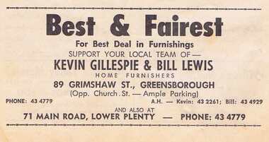
Advertisement - Digital Image, Gillespie and Lewis 1968, 25/08/1968
... main road lower plenty... Greensborough and Main Road Lower Plenty. Proprietor: Kevin Gillespie... lewis grimshaw street greensborough main road lower plenty ...Advertisement for Gillespie and Lewis of Grimshaw Street Greensborough and Main Road Lower Plenty. Proprietor: Kevin Gillespie and Bill Lewis. Copied from a Diamond Valley Football League football record from 1968.Digital copy of advertisement from booklet.diamond valley football league, gillespie and lewis, kevin gillespie, bill lewis, grimshaw street greensborough, main road lower plenty -
 Greensborough Historical Society
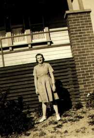
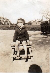
Photograph - Digital image, John Blackbourn, 1940_
... at 122 Main Road Lower Plenty. Photographs from the collection... Hospital 1936; taken at 122 Main Road Lower Plenty. Photographs ...John Blackbourn, born Greensborough Hospital 1936; taken at 122 Main Road Lower Plenty. Photographs from the collection of Peter Blackbourn, a descendant of the Chapman Stock family. Annotations to photos by Peter Blackbourn.Digital copy of black and white photograph.peter blackbourn, john blackbourn -
 Greensborough Historical Society
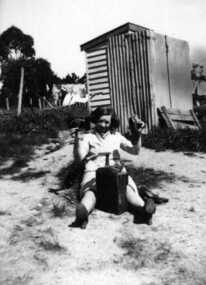
Photograph - Digital image, Kathleen Barnett, 1939c
... was taken in the backyard of 122 Main Road Lower Plenty. Photographs...; this photograph was taken in the backyard of 122 Main Road Lower Plenty ...Kathleen Barnett was born in 1917; this photograph was taken in the backyard of 122 Main Road Lower Plenty. Photographs from the collection of Peter Blackbourn, a descendant of the Chapman Stock family. Annotations to photos by Peter Blackbourn.Digital copy of black and white photograph.peter blackbourn, kathleen barnett -
 Greensborough Historical Society
Photograph - Digital image, Reg and Jean Huggett, 1930c
... 122 main road lower plenty... Main Road Lower Plenty. Photographs from the collection...), photograph taken at 122 Main Road Lower Plenty. Photographs from ...Reg and Jean Huggett (1913-2004), photograph taken at 122 Main Road Lower Plenty. Photographs from the collection of Peter Blackbourn, a descendant of the Chapman Stock family. Annotations to photos by Peter Blackbourn.Digital copy of black and white photograph.peter blackbourn, jean huggett, reg huggett, 122 main road lower plenty -
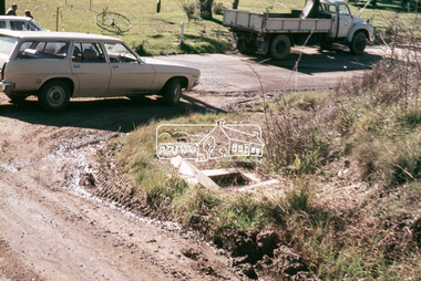
![Newspaper Clipping - Digital Image, 2000 [pounds] for public open space 1965, 05/11/1965](/media/collectors/4f729f5697f83e03086015b8/items/5eb3933621ea670b94e21892/item-media/5eb3938a21ea670b94e2e147/item-fit-380x285.jpg) Greensborough Historical Society
Greensborough Historical SocietyNewspaper Clipping - Digital Image, 2000 [pounds] for public open space 1965, 05/11/1965
... that it had purchased 1 1/2 acres of land adjoining the Plenty River... adjoining the Plenty River off Para Road zoned for public open space ...In 1965, the Board of Works advised Eltham Council that it had purchased 1 1/2 acres of land adjoining the Plenty River off Para Road zoned for public open space and offered the land to Council.An example of developments in the Greensborough area during the 1960sNews clipping, black and white text.shire of diamond valley, para road greensborough, melbourne and metropolitan board of works, plenty river, shire of eltham -
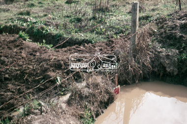
 Eltham District Historical Society Inc
Slide, In Bonds Road south of the northern arm of Montpelier Drive, Lower Plenty, 18 July 1972, 1972
... in Bonds Road, Lower Plenty outside the Martin property opposite... in Bonds Road, Lower Plenty outside the Martin property opposite ...Water drainage work undertaken by Eltham Shire Council in Bonds Road, Lower Plenty outside the Martin property opposite Montpelier Drive, July 1972 Note the blocked pit full of water and water circumnavigating the pit.35 mm colour positive transparency Mount - Agfacolor Service (Blue)Bonds Road (Martin property) 12.10 pm 18.7.72bonds road, drainage works, eltham shire council, infrastructure, lower plenty, martin property, montpelier drive -
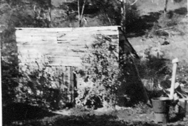 Greensborough Historical Society
Photograph - Digital image, Outhouse, Willis Vale, 1920c
... in 1964 when a fire originating from North Plenty Gorge - Kurrak...Greensborough Historical Society 34A Glenauburn Road Lower ...This photograph shows one of the out buildings at 'Willis Vale', a property owned and farmed by the Partington family from the 1870s. The derelict Willis Vale house was destroyed in 1964 when a fire originating from North Plenty Gorge - Kurrak Road - was lit by two teenage boys and made its way several kilometres down to Partington's Flat Greensborough.The hoe of a pioneer Greensborough family.Digital copy of black and white photograph.willis vale, partington family -
 Greensborough Historical Society
Photograph - Digital image, Caroline and Ferdinand Barnett and sister, 1940c
... 122 main road lower plenty... from Northcote. Taken at 122 Main Road Lower Plenty... Road Lower Plenty. Photographs from the collection of Peter ...Caroline and Ferdinand Barnett and his sister Emily Barnett from Northcote. Taken at 122 Main Road Lower Plenty. Photographs from the collection of Peter Blackbourn, a descendant of the Chapman Stock family. Annotations to photos by Peter Blackbourn.Digital copy of black and white photograph.peter blackbourn, caroline barnett, ferdinand barnett, emily barnett, 122 main road lower plenty -
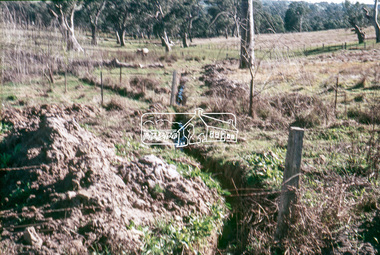 Eltham District Historical Society Inc
Slide, Looking westerly into Martins property, Lower Plenty, 18 July 1972, 1972
... in Bonds Road, Lower Plenty outside the Martin property opposite... in Bonds Road, Lower Plenty outside the Martin property opposite ...Water drainage work undertaken by Eltham Shire Council in Bonds Road, Lower Plenty outside the Martin property opposite Montpelier Drive, July 1972 Note natural gully conditions and open drain cleared through property with owner's consent.35 mm colour positive transparency Mount - Agfacolor Service (Blue)Bonds Road (Martin property) 12.10 pm 18.7.72bonds road, drainage works, eltham shire council, infrastructure, lower plenty, martin property, montpelier drive -
 Greensborough Historical Society
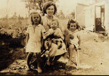
Photograph - Digital image, Blackbourn family 1936, 1936_
... 122 main road lower plenty... and Margaret Blackbourn with mother Jean; taken at 122 Main Road Lower...; taken at 122 Main Road Lower Plenty. Photographs from ...Black bourn family 1936 (left to right) Audrey, John and Margaret Blackbourn with mother Jean; taken at 122 Main Road Lower Plenty. Photographs from the collection of Peter Blackbourn, a descendant of the Chapman Stock family. Annotations to photos by Peter Blackbourn.Digital copy of black and white photograph.peter blackbourn, margaret balckbourn, john blackbourn, audrey blackbourn, 122 main road lower plenty -
 Greensborough Historical Society
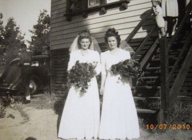
Photograph - Digital image, Bridesmaids at wedding of Marjory Barnett to Arthur Mountford, 1945c
... taken at 122 Main Road Lower Plenty. Photographs from... Brown. Photograph taken at 122 Main Road Lower Plenty ...Bridesmaids at wedding of Marjory Barnett to Arthur Mountford (left to right) Dorothy Brown, Audrey Brown. Photograph taken at 122 Main Road Lower Plenty. Photographs from the collection of Peter Blackbourn, a descendant of the Chapman Stock family. Annotations to photos by Peter Blackbourn.Digital copy of black and white photograph.peter blackbourn, marjory barnett, arthur mountford, dorothy brown, audrey brown -
 Greensborough Historical Society
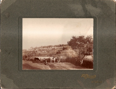
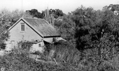
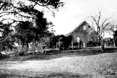
Photograph, Willis Vale 1906, taken from the hill, 1906_
... a fire originating from North Plenty Gorge - Kurrak Road - lit...Greensborough Historical Society 34A Glenauburn Road Lower ...'Willis Vale' home of the Partington family is shown in this photograph as well as the area now known as Partington's Flat. The area was owned and farmed by the Partington family from the 1870s. The derelict Willis Vale house was destroyed in 1964 when a fire originating from North Plenty Gorge - Kurrak Road - lit by two teenage boys - made its way several kilometres down to Partington's Flat Greensborough.Photograph shows an early view of Greensborough in 1906.Professional photograph in sepia mounted on dark green card. Shows Greensborough township in background with Willis Vale homestead in centre. On back: A.M.Partington Greensborough 1906.willis vale, partington family, greensborough, alan partington -
 Greensborough Historical Society
Photograph - Digital Image, Willis Vale, 1950c
... originating from North Plenty Gorge - Kurrak Road - was lit by two...Greensborough Historical Society 34A Glenauburn Road Lower ...House built by Edward Maygar, Robert Whatmough lived there mid 19th century and later sold to Partington family. It was located on the Plenty River at Partington's Flat Greensborough. The derelict Willis Vale house was destroyed in 1964 when a fire originating from North Plenty Gorge - Kurrak Road - was lit by two teenage boys and made its way several kilometres down to Partington's Flat Greensborough.Willis Vale was one of the earliest homes built in the area.Black and white digital photograph.willis vale, partington family -
 Greensborough Historical Society
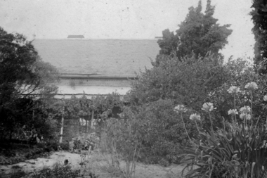
Photograph - Digital image, Willis Vale, 1939c
... originating from North Plenty Gorge - Kurrak Road - was lit by two...Greensborough Historical Society 34A Glenauburn Road Lower ...Willis Vale: House built by Edward Maygar, Robert Whatmough lived there mid 19th century and later sold to Partington family. It was located on the Plenty River at Partington's Flat Greensborough. The derelict Willis Vale house was destroyed in 1964 when a fire originating from North Plenty Gorge - Kurrak Road - was lit by two teenage boys and made its way several kilometres down to Partington's Flat Greensborough.Home of the Partington family.Digital copy of black and white photograph.willis vale, partington family, maygar family, whatmough -
 Greensborough Historical Society
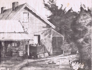
Drawing, Willis Vale by Sharyn Partington, 1983_
... a fire originating from North Plenty Gorge - Kurrak Road... Plenty Gorge - Kurrak Road - was lit by two teenage boys and made ...Drawn in 1983 by Sharyn Partington (age 15). Sharyn is the daughter of Trevor and granddaughter of Alan and Wyn Partington. The artwork would have been drawn from photos of the Partington home. The derelict Willis Vale house was vandalized in 1964 destroyed when a fire originating from North Plenty Gorge - Kurrak Road - was lit by two teenage boys and made its way several kilometres down to Partington's Flat Greensborough.An original artwork of the Partington home created by a descendant of the occupants.Pencil drawing on cream art paper. Depicts a view of Willis Vale. In black frame under glass.Signed "Sharyn P. 1983"partington, sharyn partington, willis vale, greensborough -
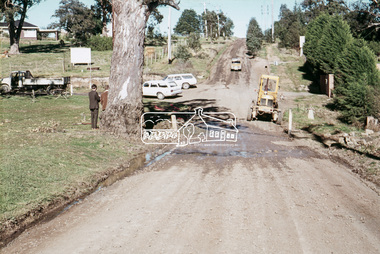
 Eltham District Historical Society Inc
Slide, In Bonds Road looking north at intersection with Montpelier Drive, Lower Plenty, 18 July 1972, 1972
... in Bonds Road, Lower Plenty outside the Martin property opposite... in Bonds Road, Lower Plenty outside the Martin property opposite ...Water drainage work undertaken by Eltham Shire Council in Bonds Road, Lower Plenty outside the Martin property opposite Montpelier Drive, July 1972 Note water flooding across Bonds Road and pile of material removed from the pit on the east side of Bonds Road.35 mm colour positive transparency Mount - Agfacolor Service (Blue)Bonds Road (Martin property) 12.10 pm 18.7.72bonds road, drainage works, eltham shire council, infrastructure, lower plenty, martin property, montpelier drive -
 Eltham District Historical Society Inc
Slide, West side of Bonds Road at culvert end wall, Lower Plenty, 18 July 1972, 1972
... in Bonds Road, Lower Plenty outside the Martin property opposite... in Bonds Road, Lower Plenty outside the Martin property opposite ...Water drainage work undertaken by Eltham Shire Council in Bonds Road, Lower Plenty outside the Martin property opposite Montpelier Drive, July 1972 Pitchers in foreground were part of the end wall which was eroded out due to water crossing the road and not going through the culvert. 35 mm colour positive transparency Mount - Agfacolor Service (Blue)Bonds Road (Martin property) 12.10 pm 18.7.72bonds road, drainage works, eltham shire council, infrastructure, lower plenty, martin property, montpelier drive -
![Photograph - Digital image, Willis Vale [house from distance], 1932c](/media/collectors/4f729f5697f83e03086015b8/items/54fd54082162f10d30c05b8a/item-media/54fd54392162f10d30c05f8f/item-fit-380x285.jpg) Greensborough Historical Society
Greensborough Historical SocietyPhotograph - Digital image, Willis Vale [house from distance], 1932c
... North Plenty Gorge - Kurrak Road - was lit by two teenage boys... originating from North Plenty Gorge - Kurrak Road - was lit by two ...Willis Vale: House built by Edward Maygar, Robert Whatmough lived there mid 19th century and later sold to Partington family. It was located on the Plenty River at Partington's Flat Greensborough. Land use included farming and orchards. The derelict Willis Vale house was destroyed in 1964 when a fire originating from North Plenty Gorge - Kurrak Road - was lit by two teenage boys and made its way several kilometres down to Partington's Flat Greensborough.Home of the Partington familyDigital copy of black and white photograph.willis vale, partington family, whatmough, maygar -
 Greensborough Historical Society
Photograph - Digital Image, Willis Vale, 1920c
... North Plenty Gorge - Kurrak Road - was lit by two teenage boys... originating from North Plenty Gorge - Kurrak Road - was lit by two ...Willis Vale: House built by Edward Maygar, Robert Whatmough lived there mid 19th century and later sold to Partington family. It was located on the Plenty River at Partington's Flat Greensborough. Land use included farming and orchards. The derelict Willis Vale house was destroyed in 1964 when a fire originating from North Plenty Gorge - Kurrak Road - was lit by two teenage boys and made its way several kilometres down to Partington's Flat Greensborough.Home of the Partington familyDigital copy of black and white photograph.willis vale, partington family, maygar, whatmough -
 Greensborough Historical Society
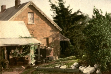
Photograph - Digital image, Willis Vale in Colour, 1940c
... North Plenty Gorge - Kurrak Road - was lit by two teenage boys... originating from North Plenty Gorge - Kurrak Road - was lit by two ...Willis Vale: House built by Edward Maygar, Robert Whatmough lived there mid 19th century and later sold to Partington family. It was located on the Plenty River at Partington's Flat Greensborough. Land use included farming and orchards. The derelict Willis Vale house was destroyed in 1964 when a fire originating from North Plenty Gorge - Kurrak Road - was lit by two teenage boys and made its way several kilometres down to Partington's Flat Greensborough.Home of the Partington familyDigital copy of colour photograph.willis vale, partington, whatmough, maygar -
![Photograph - Digital image, Willis Vale [front door], 1900c](/media/collectors/4f729f5697f83e03086015b8/items/55029fb42162f11024c2fdd5/item-media/55029fe62162f11024c300cd/item-fit-380x285.jpg) Greensborough Historical Society
Greensborough Historical SocietyPhotograph - Digital image, Willis Vale [front door], 1900c
... North Plenty Gorge - Kurrak Road - was lit by two teenage boys... originating from North Plenty Gorge - Kurrak Road - was lit by two ...Willis Vale: House built by Edward Maygar, Robert Whatmough lived there mid 19th century and later sold to Partington family. It was located on the Plenty River at Partington's Flat Greensborough. Land use included farming and orchards. The derelict Willis Vale house was destroyed in 1964 when a fire originating from North Plenty Gorge - Kurrak Road - was lit by two teenage boys and made its way several kilometres down to Partington's Flat Greensborough.Home of the Partington familyDigital copy of black and white photograph.willis vale, partington -
 Melbourne Tram Museum
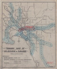
Drawing, H. S McComb, "Tramway Map of Melbourne & Suburbs", mid 1930's
... Road and Plenty Road .18 - 1921 - Footscray lines .19... of Camberwell station .17 - 1920 - FNPTT - St Georges Road and Plenty ...Set of 19 drawings showing the development of the Melbourne tramway system between 1885 and 1921. Based on MMTB drawing "Tramway Map of Melbourne & Suburbs" P4609, 18 sheets showing year by year development of the cable and electric tram system, printed on off white paper. Mr. McComb had intended it would appear to do further work - with some 20 sheets printed on brown card paper but not used (.19 - same drawing) Each sheet has the year in red at the bottom right hand corner of the sheet. .1 - 1885 - with the Richmond line and main rail lines coloured in showing a catchment area. .2 - 1886 - shows the new cable line in Collins St and has a note that no suburban line constructed in 1886 .3 - 1887 - Bourke and northern lines and Brighton Beach to Sandringham and Hawthorn to Kew .4 - 1888 - Swanston St, Domain Road, Chapel and inner circle and towards Hurstbridge.\ .5 - 1889 - Rathdown St and Toorak Road .6 - 1890 - South and Port Melbourne, North Melbourne and Northcote. Rail lines - Ashburton and parts of the outer circle to Oakleigh. .7 - 1891 - St Kilda Esplanade and northern section of the outer circle. .8 - 1906 - NMETL .9 - 1910 - PMTT - High St and Wattletree Road .10 - 1911 - PMTT Dandenong Road .11 - 1913 - Glenferrie Road, Cotham Road, Balaclava and Glenhuntly Road .12 - 1914 - small extension in High St .13 - 1915 - Malvern Road and High St Kew .14 - 1916 - HTT and MBCTT lines and Whitehorse Road .15 - 1917 - Burke Road .16 - 1918 - Burke Road north of Camberwell station .17 - 1920 - FNPTT - St Georges Road and Plenty Road .18 - 1921 - Footscray lines .19 - base drawing only. Does not show the VR tramlines. See Reg Item 2154 for associated notes.See individual sheets.trams, tramways, times, cable trams, railways, tramways, melbourne, maps -
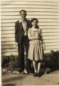
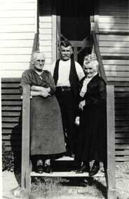
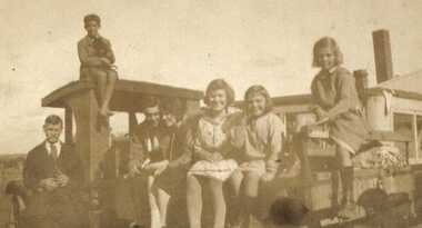 Greensborough Historical Society
Photograph - Digital image, Barnett and Blackbourn circa 1922, 1922c
... of 122 Main Road Lower Plenty. On roof: Laurie Barnett. On ground... and Blackbourn families at rear of 122 Main Road Lower Plenty. On roof ...Members of the Barnett and Blackbourn families at rear of 122 Main Road Lower Plenty. On roof: Laurie Barnett. On ground left to right: Ferdinand Barnett, Ted and Jean Blackbourn, Myrtle, Marjory, Ivy Barnett. Photographs from the collection of Peter Blackbourn, a descendant of the Chapman Stock family. Annotations to photos by Peter Blackbourn.Digital copy of black and white photograph.peter blackbourn, barnett family, blackbourn family -
![Photograph - Digital image, Willis Vale [3], 1878c](/media/collectors/4f729f5697f83e03086015b8/items/54fd5aeb2162f10d30c0aed5/item-media/54fd5b042162f10d30c0b12d/item-fit-380x285.jpg) Greensborough Historical Society
Greensborough Historical SocietyPhotograph - Digital image, Willis Vale [3], 1878c
... and later sold to Partington family. It was located on the Plenty... North Plenty Gorge - Kurrak Road - was lit by two teenage boys ...Ellen and Charles Partington at Willis Vale: House built by Edward Maygar, Robert Whatmough lived there mid 19th century and later sold to Partington family. It was located on the Plenty River at Partington's Flat Greensborough. Land use included farming and orchards. The derelict Willis Vale house was destroyed in 1964 when a fire originating from North Plenty Gorge - Kurrak Road - was lit by two teenage boys and made its way several kilometres down to Partington's Flat Greensborough.Home of the Partington familyDigital copy of black and white photograph.charles partington, willis vale, ellen partington -
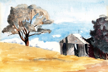 Greensborough Historical Society
Painting - Digital image, Barn at Willis Vale, 1920c
... from North Plenty Gorge - Kurrak Road - was lit by two teenage... a fire originating from North Plenty Gorge - Kurrak Road ...Painting of a barn at Willis Vale. 'Willis Vale' was owned and farmed by the Partington family from the 1870s. The derelict Willis Vale house was destroyed in 1964 when a fire originating from North Plenty Gorge - Kurrak Road - was lit by two teenage boys and made its way several kilometres down to Partington's Flat Greensborough. Gary Partington thought the barn was probably associated with the bull yard. (Note: Only some abandoned stumps existed when Gary was very young in the mid to late 1940s) Digital copy of painting.willis vale, partington family