Showing 7613 items matching " road development"
-
 Ringwood and District Historical Society
Pamphlet, Subdivisional Auction Sale, Bedford Park, Ringwood - 1924
Bedford Park subdivisional development did not eventuate. The land adjoining the railway line became parkland with provision for sporting facilities and the remainder was purchased by the Education Department as the site for Ringwood High School/Secondary College. Double sided bifolded auction sale advertisement including subdivision features and local facilitiesSubdivision plan includes Bedford Road, Graham Road, Joyce Street, Anderson Street, and Adams Street -
 Ringwood and District Historical Society
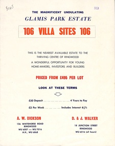
Flyer, Land Sale Brochure, Glamis Park Estate (Wantirna, Vic.) - 1959
Street name Carnarvon Avenue on the subdivision plan became Selkirk Avenue at some stage during or subsequent to development of the Estate.Bi-folded advertisement for sale of residential allotments, including summary of subdivision features and local facilities.Subdivision includes Wantirna streets - Wantirna Road, Carnarvon Avenue, Inchcape Avenue, St Thomas Avenue, St Davids Drive, Dudley Avenue, Angus Avenue. Agents - A.W. Dickson, 136 Whitehorse Road, Ringwood, Telephone WU 6007, WU 7016, A.H. WU 6868. D. & J. Walker, 18 Junction Street, Ringwood, Telephone WU 6516 (all hours). -
 Ringwood and District Historical Society
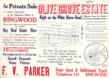
Flyer, Land Sale Advertisement, Olive Grove Estate, Ringwood, Vic. - 1926
Further development of 9 shop sites took place along Whitehorse Road (later street numbers 58 to 64 Whitehorse Road) between New Street and Olive Grove around 1950 - See Victorian Collections reference 5227.Single sided page with red and blue print advertising Olive Grove Estate business and residential allotments, including subdivision plan and summary of local services.Subdivision includes Whitehorse Road, New Street, and Olive Grove. Agent - F.V. Parker, Telephone 131, Ringwood. -
 Ringwood and District Historical Society
Photographs, Suda and Khassa Ave Ringwood, Before and after Ringwood Bypass Construction 1993
B&W photograph taken by Ringwood Historical Research Group. Also added extract from Melways showing the roads before the Bypass (1987) showing the planned Bypass cutting these two roads, and Melways (2018) showing new alignment with Bypass11063A: 17.1.93 Suda Ave Still intact towards Maroondah Hwy. Taken near Khassa Pde 11063B: 17.1.93 Suda Ave. House gone. Near Khassa Pde 11063C: 17.1.93 Ringwood Bypass from cnr Khassa Pde and Suda Ave towards Mt Dandenong Rd 11063D: 17.2.93 Suda Ave. House gone. 11063E: 21.2.93 cnr Khassa Pde and Suda Ave. Direction of next cut for the Ringwood Bypass. Trees to go. 11063F: 21.2.93 Connection from ??? St to North end of Suda Ave 11063G: 22.2.93 Adelaide St to right (closed). Mile Ave in front and turning left. Note the grey wall along Miles St to support the new car park development. Shrub on left is in the bowling club. -
 Ringwood and District Historical Society
Photographs, Eastland Car park Construction, Ringwood, 1992-93
... 11064A: 21.2.92 Eastland car park development from near... development from Warrandyte Road from Op. Bond St. 11064D: 4.1.93 New ...B&W photograph taken by Ringwood Historical Research Group. Also added extract from Melways showing the roads before the Bypass (1987) showing the planned Bypass cutting these two roads, and Melways (2018) showing new alignment with Bypass11064A: 21.2.92 Eastland car park development from near Safeway 11064B: 21.2.92 Eastland car park development from Adelaide St 11064C: 4.1.93 Eastland car park development from Warrandyte Road from Op. Bond St. 11064D: 4.1.93 New Myer Eastland car park viewed from Safeway's Roof 11064E: 17.1.93 Eastland car park near where Esso Garage was 11064F: 21.2.92 Eastland car park from cnr of Adelaide St and Eastland -
 Ringwood and District Historical Society
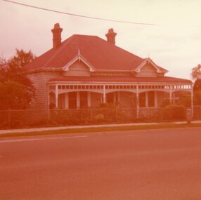
Photograph, "Lyndhurst" 26 Wantirna Rd, Ringwood, May 1979
3 colour photographs taken by Richard Carter, May 1979, of "Lyndhurst", 26 Wantirna Rd, Ringwood, shortly after the property was sold by "Booty" Goodwin for unit development. (NW corner of Arlington St). -
 Ringwood and District Historical Society
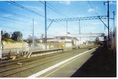
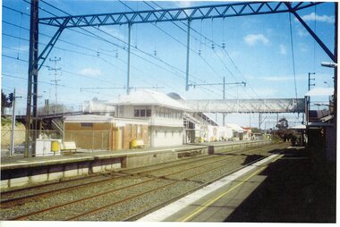
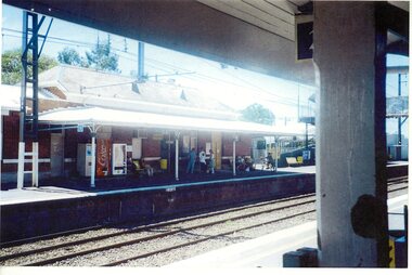
Photograph, Ringwood Railway Station before development- circa 2000
Coloured photograph"Written on back of photograph" Ringwood station before development. Platform 2 -
 Ringwood and District Historical Society
Photograph, Ringwood Railway Station before development- circa 2000
Coloured photograph"Written on back of photograph" Ringwood station before development. Platform 2 -
 Ringwood and District Historical Society
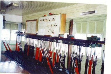
Photograph, Ringwood Railway Station before development- circa 2000
Coloured photograph"Written on back of photograph" Ringwood station before development. Signal box -
 Ringwood and District Historical Society
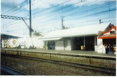
Photograph, Ringwood Railway Station before development- circa 2000
Coloured photograph"Written on back of photograph" Ringwood station before development. Platform 1 -
 Ringwood and District Historical Society
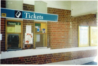
Photograph, Ringwood Railway Station before development- circa 2000
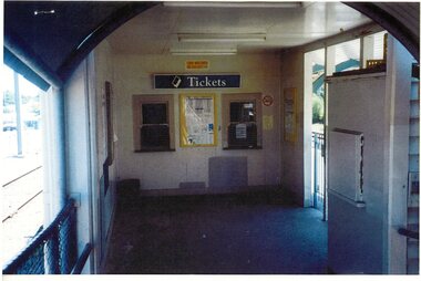
Coloured photograph"Written on back of photograph" Ringwood station before development. Ticket Office -
 Ringwood and District Historical Society
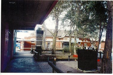
Photograph, Ringwood Railway Station before development- circa 2000
Coloured photograph"Written on back of photograph" Ringwood station before development. Front Entrance -
 Ringwood and District Historical Society
Photograph, Ringwood Railway Station before development- circa 2000
Coloured photograph"Written on back of photograph" Ringwood station before development. Platform 2 -
 Ringwood and District Historical Society
Photograph, Ringwood Railway Station before development- circa 2000
Coloured photograph"Written on back of photograph" Ringwood station before development. Ticket Office -
 Ringwood and District Historical Society
Photograph, Ringwood Railway Station before development- circa 2000
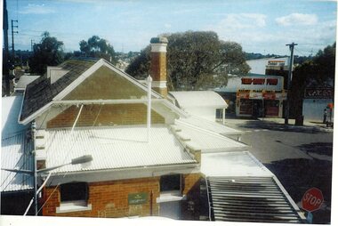
Coloured photograph"Written on back of photograph" Ringwood station before development. Roof view -
 Ringwood and District Historical Society
Photograph, Ringwood Railway Station before development- circa 2000
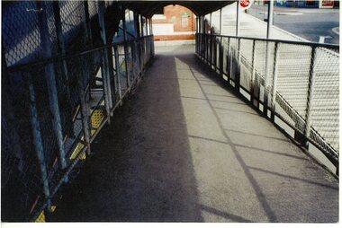
Coloured photograph"Written on back of photograph" Ringwood station before development. Ramp over track -
 Bendigo Military Museum
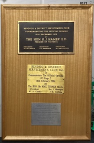
Plaque - BDSC, BDRSLINC REDEVELOPEMENT, C.1979, 1994, 2014
The Bendigo & District Servicemen's Club became the Bendigo District RSL Sub Branch Inc in the year 2000 hence the difference in the name titles on the plaques. Refer Cat No 8073PLight coloured timber frame with 3 plaques different colours, shapes and sizes. 1. Top plaque re the opening of the Bendigo & District Servicemen's Club in Havilah Road Bendigo on 19.12.1979. 2. Centre plaque re stage 2 re development of the above building on 18.12.1994. 3. Bottom plaque re the re development of the Bendigo District RSL Entertainment Complex on 27.7.2014.brsl, smirsl, bdsc, bdrslinc, plaques -
 Warrnambool and District Historical Society Inc.
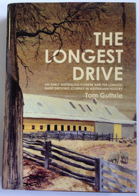
Book, Tom Guthrie, The Longest Drive, 2 McIntyre Street
Biography of Thomas Guthrie (1833-1928)This is a hardcover book of 635 pages. The dust cover is multi-coloured with an image of a painting of the woolshed at Rich Avon on the front. The book has a dark red cover.non-fictionBiography of Thomas Guthrie (1833-1928)western victoria early farming sheep farming and droving guthrie affleck, early farming sheep farming and droving guthrie affleck, droving guthrie affleck, guthrie affleck -
 Warrnambool and District Historical Society Inc.
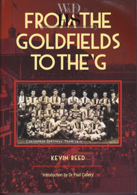
Book, Kevin Reed, From the Goldfields to the G, 2014
An account of the development of Australian Rules football in both rural and suburban Victoria.This is a paper back book with a red and gold cover with a photograph of Costerfield Football Team, 1919 on the cover (335 pages) The book is signed inside by Kevin Reed non-fictionAn account of the development of Australian Rules football in both rural and suburban Victoria.warrnambool, kevin reed, dr john douglas, warrnambool cricket 1980's, warrnambool football 1970's 1980's -
 Warrnambool and District Historical Society Inc.
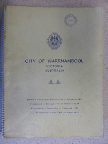
Book, City of Warrnambool, 1961
This book is a report on the development of the city of Warrnambool in 1960. The seven sections it covers are, 1 Town Planning and beautification 2 Culture and Education 3 Town promotion and tourism 4 Recreation and youth work 5 Industrial development 6 Town Development 7 Community organization. There is a very comprehensive study on each of the sections. The population at this time was 15697. This report has social, historical and research significance. It is a comprehensive study of the city as it was in 1960, listing clubs, organisations schools and sporting clubs. It provides information on any development such as the Olympic pool and St Pius X1 school in West Warrnambool and the building of the Pontings store on the Lava St corner. It relates facets of our history which have changed dramatically in the last 60 years with the report on Peter Hand’s tobacconist having 3 vehicles covering the district travelling 4700 miles a month selling cigarettes. It provides statistical evidence for organisations such as Australia Post, train and freight services and the hospitals.Large yellow soft card cover with spiral binding. Title and city details are printed in blue on cover with city logo towards top of front cover. Pages are not numbered. It is divided into seven sections, each denoted by blue page with section title printed in blue on page.Circular stamp on front cover,” Warrnambool Standard Proprietary Limited.” K L Arnel town clerk. warrnambool 1960, warrnambool directory 1960 -
 Warrnambool and District Historical Society Inc.
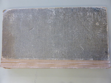
Document - Ledger: Shire of Warrnambool Engineers Correspondence CRB 1933-1935, Circa 1930
A detailed continuum of correspondence showing the progress of development in the district and the co-operation and cost sharing between the different shires to have work completed.The correspondence contained within this book shows the link between the Shire Of Warrnambool and the Country Roads Board. Some letters provide costings of materials and plant and equipment and wages for workmen. Dark green cloth covers with fawn suede spine and corner binding. Navy Blue patterned paper inside front and back covers. Alphabetical index at the front. Pages 1-148 contain copies of correspondence .Remainder is not used. There is a typed foolscap sized sheet printed with work conditions, included loose at the rear of the book.On spine: Letter Book with CRB printed in black underneath. Country Roads Board 1933-193 vertically on leather spine at front.warrnambool, warrnambool shire council, country roads board, 1933-1935, j crawley, warrnambool shire engineer -
 Warrnambool and District Historical Society Inc.
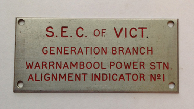
Sign - Identification plate: SEC Branch Alignment Indicator, Mid 20th century
The State Electricity Commission was established in 1920 with the development of the Yallourn Power Station and brown coal was used for 90% of Victoria’s electricity supplies. In the 1990s the Commission was abolished and electricity companies were privatized. In Warrnambool electricity was officially connected to the city in 1924. This plate is one taken from a Warrnambool power station. One power station in Warrnambool today being located in Botanic Road.This plate is of some interest as a reminder of the times when the State Electricity Commission controlled power supplies in Victoria.This is a small rectangular metal plate with four holes at each corner for attachment to a Warrnambool Power Station. S.E.C. of VICT. Generation Branch Warrnambool Power Station Alignment Indicator No. 1 s.e.c. warrnambool, state electricity commission victoria, warrnambool -
 Warrnambool and District Historical Society Inc.
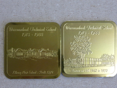
Souvenir - Warrnambool Technical School 1913-1988 souvenir coasters and placemats, 1988
These coasters and placemats are souvenirs of the 75th anniversary of the Warrnambool Technical School. The scenes depicted are Original Timor Street School built 1926, Timor Street with second storey 1967, New School built 1972. Dunkeld Annexe commenced 1975, Library new School built 1972, Annexe on Hill 1962 to 1978. They depict the ongoing development of the school which now operates as Brauer College in Caramut Road Warrnambool. Historical and social. A common item in the 20th century and as one of Warrnambool’s largest and longest running school would have some interest for a large number of local people. The artist John Moir was a local artist.Six White drink coasters with different black and white sketches. Rounded corners edged in black. In olive green box. Set two consists of two gilt metal coasters with engravings. Both are incorrectly labelled. Blue felt on the reverse. The scenes depicted are 000828.1.1 Original Timor Street School built 1926, 000828.1.2 Timor Street with second storey 1967, 000828.1.3 New School built 1972. 000828.1.4 Dunkeld Annexe commenced 1975, 000828.1.5 Library new School built 1972, 000828.1.6 Annexe on Hill 1962 to 1978. They depict the ongoing development of the school which now operates as Brauer College in Caramut Road Warrnambool. The two gilt metal coasters 000828.2.1 Library new School Built 1972 000828.2.2 Annexe on Hill 1962 to 1973 Placemats 000828.3.1 Original Timor Street School built 1926, 000828.3.2 Timor Street with second storey 1967, 000828.3.3 New School built 1972. 000828.3.4 Dunkeld Annexe commenced 1975, 000828.3.5 Library new School built 1972, 000828.3.6 Annexe on Hill 1962 to 1978.All have artist’s signature, John Moir, Warrnambool Technical School 1913-1988. warrnambool, warrnambool technical school, warrnambool annexe, timor street technical school, john moir, warrnambool souvenirs -
 Warrnambool and District Historical Society Inc.
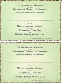
Document, Made in Australia Exhibition, 1950s
No information has been found regarding this exhibition in Warrnambool. The card design indicates that the exhibition may have been in the 1950s. The Warrnambool Chamber of Commerce has been operating at various times in the 20th century and was formed by the local businesses to promote Warrnambool as a city for business initiatives, tourism and economic development. These tickets are of some interest as an example of the activities of the Warrnambool Chamber of Commerce in the mid 20th century. These are two identical tickets, with black printing on a green background on one side and blank on the other side. The edges of the cards are gold- tipped in a serrated pattern.‘The President and Committee of the Warrnambool Chamber of Commerce requests the pleasure of the company of ….. at the Made in Australia Exhibition at the Warrnambool Town Hall on Thursday Evening, October 22nd, E. M. Dempster, Organizer’. made in australia exhibition, warrnambool, warrnambool, warrnambool chamber of commerce, e dempster -
 Warrnambool and District Historical Society Inc.
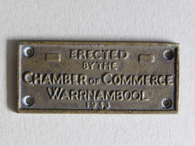
Brass Plate, Chamber of Commerce 1933, 1933
This plaque has been attached to a Warrnambool installation in 1933. It is not known to which site this refers but it may have been the Warrnambool Information Pavilion which was erected outside the old Warrnambool City Council Chambers. There have been many Warrnambool Chambers of Commerce over the years. These were established by Warrnambool businessmen and women to promote the interests of the town/city and to encourage the development of local industry and the tourism trade. This plaque is of great local interest but unfortunately does not have a clear provenance.This is a small brass plaque. The plaque has four holes at each corner for attachment to a building or other object. ‘Erected by the Chamber of Commerce, Warrnambool, 1933’warrnambool chamber of commerce, warrnambool city council chambers, plaque -
 Kiewa Valley Historical Society
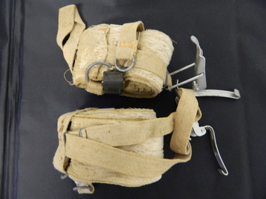
Ski Skins - Pair
Ski skins and webbing were introduced into the Victorian Alps by European skiers. Enthusiasts travelled to enjoy the snow and to explore the Victorian Alps including the Bogong High Plains. This equipment enabled them to travel over snow without slipping when going up hills. They took the skins off when they wanted to slide down hills. In later years waxes were used for cross country skiing and then 'fish tail' markings on the back of skis to enable skiers to travel distances up and down mountains. Later developments also included motor transport (replacing horses to get to the snow line) and roads to take skiers to the ski fields and mechanised tows to take skiers up mountains so they could ski down (downhill skiing).Skiers visited the Bogong High Plains especially during the years of the State Electricity Commission of Victoria's construction of the Kiewa Hydro Electric Scheme from the 1930's onwards. Tourists to the area increased during this time and influenced the development of Falls Creek.Long cream strips with soft short 'fur' on one side and a type of strong hessian on the back with the length of the middle and sides stitched. At one end an adjustable strap is attached to a steel, hinged clasp and at the other end is a loop that fits over the ski. A quarter of the way from each end is a steel attachment for fastening over the ski - the 'toe' end with a rubber embossed flap and the other with a short and long strap each with a steel ring at the end.On the rubber attachment: 'vinersa/pat uno'ski skins; bogong high plains; falls creek -
 Kiewa Valley Historical Society
Photographs – Bogong High Plains - Set of 16 black and white photographs mounted back and front on 3 pieces of heavy black card likely removed from a photograph album
After World War II, the Kiewa Hydro-Electric Scheme was started in the Kiewa River Valley by the State Electricity Commission of Victoria. On land previously used only for summer cattle grazing in the natural alpine grasslands, the first ski lodge was built in 1948 by workers from the hydro scheme as skiing was a popular recreation. Many of the hydro employees were of European background and had grown up enjoying skiing and snow sports in their homelands and were keen to continue to pursue their winter sports interests. The first lift, a rope tow, was built at Falls Creek in 1951 and the first chairlift in Australia was constructed there in 1957. Two T-Bars were opened in 1961. In 1964, the Victorian Municipal Directory recorded that Falls Creek had 29 ski club lodges and 16 commercial lodges. The area became a popular tourist destination for both winter and summer sports.Employees of the State Electricity Commission of Victoria in the Kiewa River Valley were the earliest skiers on the Bogong High Plains and built one of the first ski lodges at Falls Creek. They were amongst those pivotal in the development of the skiing and tourist industry at Falls Creek and on the Bogong High Plains. Black and white photographs of varying sizes mounted decoratively on heavy black Card. Some pages display a brief description printed in white ink 1. 4 photographs- displayed diagonally across page. 2 pictures of a group of men standing in the snow in front of a car with a loaded trailer behind. 1 photo of skiers. 1 photo of show hanging in tree branches. 2. 2 photographs- showing Upper Kiewa Road with snow in the background 3. 3 photographs- of skiers and 1 photo of 2 of men posing in the snow & 1 photo of 2 men posing shirtless in warmer weather. 4. 2 photographs- arranged diagonally on page showing early buildings and construction at Bogong Village 5. 2 photographs- 1 showing view of Bogong Village from higher up the mountain. 1 showing early Bogong High Plains road 6. 1 photograph- showing view down along Kiewa Valley from higher up in the mountains 1. Handwritten in white ink – A TRIP TO THE PLAINS 2. Handwritten in white ink – UPPER KIEWA ROAD MT FAINTER IN BACKGROUND 3 – 6. No markings bogong village; upper kiewa road; bogong high plains; falls creek; skiers -
 Kiewa Valley Historical Society
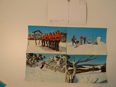
Postcards - Falls Creek - Set of 4
Postcards were available at tourist destinations to promote the resort by enabling visitors to write to friends and family.The Kiewa Hydro Electric Scheme hastened the development of Falls Creek as a popular destination for skiers. Roads, buildings including accommodation & chalets, ski clubs, snow vehicles, ski tows etc enabled visitors to live and ski in the snow. When construction of the KHES was completed Falls Creek continued to develop both as a winter and summer resort. Serrated edge colored postcards. 1. "On Langlauf Skis in the Australian Snowfields' - Photograph by Uwe Steinward 2. 'Ski-school and instructors at Falls Creek, Victoria' Photograph by Uwe Steinward x2 3. Overlooking the Victorian snowfields, Falls Creek, Victoria' Photograph by Uwe Steinward 4. 'Skiing down the slopes at Falls Creek, Victoria.' photograph by Uwe Steinward x3falls creek, snow, skiing, alpine sport, langlauf skmiing, uwe steinward -
 Kiewa Valley Historical Society
Set of 2 hand coloured photographs of early Mount Beauty, photographs of Mount Beauty, 1947/48
Construction of the town of Mount Beauty commenced in 1946 and continued until 1952. It was built to provide family accommodation for workers engaged in the construction of the hydro electric power scheme. As well as housing, there was an administration building, staff hostel, merchandising centre, workmen's camps, base stores and workshops and the Mount Beauty Terminal Station. The first house was occupied in November, 1946 by the then manager of the trading store, with a frontage onto Hollonds Street. The total number of houses erected was 488, 162 custom built and 326 prefabricated. The main workmen's camp can be seen just left of the centre of the photograph and accommodated 144 men at the time of the photograph. By 1950 it could accommodate 1200men. Photo No. 1 is taken in 1947/early 1948 as there is no evidence of the staff hostel under construction. This hostel was commenced in August/September 1948 and is clearly shown in photograph No. 2, dating this photo as 1948 as it is before the completion of the bypass road connecting to the main (high plains) road. This road was constructed in 1939 and in 1948 followed the route of Tawonga Crescent. This remained in use until the bypass construction was completed in early 1949 and does not appear to be finished in this photograph.. Both photographs are taken from the power line easement adjacent to the Bright road.Significant historical pictorial record of the development of a town from grazing land. The type of terrain that had to be surveyed and then to construct roads and other infrastructure, with very little machinery, is also of prime significance in the development of the Kiewa Hydro Electric Scheme.Two photographs, both hand painted to show colours, and both of Mount Beauty c 1947/48 not long after commencement of construction of homes and facilities for workers.Photo No.1 - on back of photo, left upper corner, faintly in pencil, SPIKE, underneath this is written T Pay,. Photo No. 2 - on back of photo, left upper corner, faintly in pencil, Jmount beauty, housing, accommodation -
 Kiewa Valley Historical Society
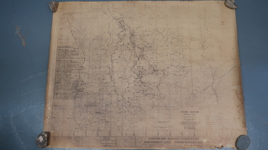
Map - Kiewa Scheme General Plan
Existing and possible future roads are numbered and named 1 - 45. The plan is based on an aerial photos taken March 1945. It includes revisions up to 1951. Signed by H.H.C. Williams, construction engineer. Mountains, rivers, roads and SECV places are named, also SECV infrastructure and construction eg. workers camps, Power stations.Significant for the information re the Kiewa Hydro Electric Scheme's development.Yellowed paper with brown print. Kiewa Scheme general plan showing its development. A lot of information is recorded. Note: Dyeline print was used which causes fading when exposed to light. Handwritten: 'Bob Duncan'bob duncan, kiewa hydro electric scheme, secv, khes development