Showing 845 items
matching surveyor
-
 Warrnambool and District Historical Society Inc.
Publication, Wild & Beissel Pty Ltd, Booklet, 1939
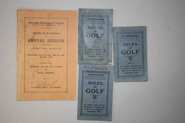
One of these booklets contains the Minutes of Procedure of the Annual Session of the Municipal Association of Victoria in October 1939. The other three items are booklets containing the rules of golf as approved by the Golf Club of St Andrews in 1920. The four items belonged to Rolf Crawley who had a private surveying, engineering and architects practice in Warrnambool and was also the engineer for the Shire of Warrnambool from 1935 to 1968. The Shire of Warrnambool existed from 1863 to 1994. Rolf Crawley’s grandfather, father and uncle were also engineers and worked in that capacity or as the Shire Secretary for the Shire of Warrnambool, with the Crawley family recording a total of 132 years of service to the Shire. The items came into the possession of Michael Hand who took over the private surveying business of Rolf Crawley in Warrnambool. The Warrnambool and District Historical Society acquired the items, along with several ledgers and other Crawley memorabilia, from the estate of Michael Hand. These booklets are of minor interest as items that belonged to Rolf Crawley, the engineer for the Shire of Warrnambool in the mid 20th century..1 This is a buff-coloured booklet of 121 pages. It has printed matter and one black and white photograph. It has two mauve stamps on the front cover and on the first page. .2.3.4 These are three small identical booklets with blue covers. They each contain 48 pages and have black and white advertisements. They have handwritten names on the front covers. .1 ‘Rolf L. Crawley Civil Engineer, Drainage and Water Supply Engineer, Licensed Surveyor, Registered Architect, Warrnambool’ .2.3.4. ‘Rolf L. Crawley Warrnambool’ ‘Nettie Crawley’ rolf crawley, warrnambool, shire of warrnambool -
 Ringwood and District Historical Society
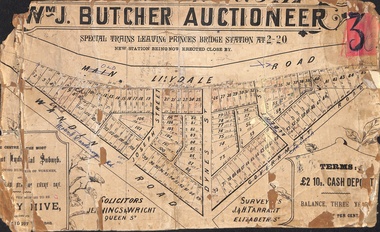
Poster - Land Sale, Wm J. Butcher, Auctioneer - Albert Park Estate, Ringwood - c.1890
Central section of land sale subdivision advertisement glued to heavy cardboard backing. Photocopied SLV image of original advertisement shows map of 117 allotments for sale in Main Lilydale Road (later Old Lilydale Road), Wandin Road (later Mount Dandenong Road), Joseph Street, Dynes Street, Albert Street (later Wyrunga Street) and Government Road (later Carcoola Road), Ringwood East.Solicitors - Jenningw & Wright, Queen Street. Surveyors - J.&H. Tarrant, Elizabeth Street. Terms £2 10s cash deposit, balance three years at six per cent. -
 University of Melbourne, Burnley Campus Archives
Plan - Photocopy, Proposed Reserve for Horticultural and Experimental Garden in the Survey Paddock Richmond, 1862-1948
Photocopy of Plan Gazetted 01.08.1863. From Central Plan Office Department of Natural Resources.Original signed by Clement Hodgkinson, Deputy Surveyor General. Stamped Department of Lands and Survey 7.12.48 Neg.18377. Handwritten notes on back "Melb Roll 23, R.19(A)"burnley, horticultural and experimental garden, survey paddock, richmond, clement hodgkinson -
 Ringwood and District Historical Society
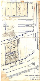
Map, Partially trimmed copy of a retail and residential auction advertisement, Ringwood, Vic. - 1926
One of 3 unrelated land subdivision maps on cardboard backing. Numbered allotments on Nelson Street, Seymour Street and Whitehorse Road, Ringwood.W.J. Bonwick, Licensed Surveyor, Phone WU4830. Location map also includes Bourke Street, Bond Street, Charter Street, Ringwood Street, and Shops and Market sites in Ringwood. -
![Plan, Surveyor's Street Plan of Melbourne 1837 [copy], 1837_](/media/collectors/4f729f5697f83e03086015b8/items/534ccbc12162ef06c8d2cbf7/item-media/58afbfe2d0ce1616fcdf244b/item-fit-380x285.jpg) Greensborough Historical Society
Greensborough Historical SocietyPlan, Surveyor's Street Plan of Melbourne 1837 [copy], 1837_
Copy of Surveyor's Street Plan of Melbourne 1837. Donated by Patsy Coverdale and accompanied by brief details of her family connection to the map. Copies of plan available for sale from Greensborough Historical Society.Map of early Melbourne with connections to a current resident.Copy of plan, mounted on timber and framed.melbourne street plan, coverdaye, umpleby -
 Bendigo Historical Society Inc.
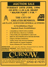
Document - IAN DYETT COLLECTION: AUCTION CATALOGUE - THE CITY OF GREATER BENDIGO
Bright yellow auction catalogue with black printing for a sale on 18th June, 1996 for the City of Greater Bendigo, AH Plant, Surveyor General & Others at Strathfieldsaye Depot, Strathfieldsaye. For sale were Earth moving equipment, tractors, 3 P/L equipment, caravans, various mowers, chippers,shredders, brush cutters, trailers, scrap, tools, Surveyors equipment, office furniture & computer equipment, drums of bitumen and R/C concrete drains. J. H. Curnow & Son P/L were the auctioneers. Map of how to get to auction site inside front cover. Loose pink Supplementary List, account Coliban Water listing backhoe/F.E. loaders, tractor, tipper crane and 4WD wagon listed.business, auctioneers, j h curnow & son pty ltd, ian dyett collection - auction catalogue - the city of greater bendigo, ah plant, surveyor general & others, darryl young, ian dyett, j h curnow & son p/l, coliban water, noel dyett, fred dyett -
 Bendigo Historical Society Inc.
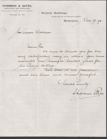
Document - W.D.MASON COLLECTION: LETTER, 17 November08
Cream Document, W.D.Mason Collection, Letter from Hyndman & Bates,Architects and Surveyors Corner Collins and Swanston Streets, Melbourne, dated 17.11.(18)98 to Mr Owen Williams - we have to thank you for the very satisfactory way in which you have executed the simple leaded glass for Mrs. Craig's Cottage.business, retail, w d mason -
Kew Historical Society Inc
Archive (Sub-series) - Subject File, Kew Historical Society, HODDLE Survey, 1997
Various partiesReference, Research, InformationSecondary Values (KHS Imposed Order)Photocopied correspondence and maps (surveys) relating to surveys ordered by Robert Hoddle, Government Surveyor. Authors of letters and information include Gwen McWilliam and Jack Hackett. Much of the correspondence relates to the site of the ‘Hoddle Tree’, currently located in the Kew Golf Course. Jack Hackett’s original map is contained in the map drawers in the Society’s archive.kew historical society - archives, kew (vic) - history, robert hoddle - surveyor, hoddle tree - kew (vic), jack hackettkew historical society - archives, kew (vic) - history, robert hoddle - surveyor, hoddle tree - kew (vic), jack hackett -
 Bendigo Historical Society Inc.
Document - LANDS OFFICE - PLANS FORWARDED TO CROWN LANDS OFFICE, 1.9.1871 to 5.4.1880
Document: hard cover journal, brown cover with darker tan spine. 239 pages. Contains index at front of journal. Listings of plans forwarded to Melbourne Crown Lands Office by Bendigo Office. Alphabetical listing in front followed by numbered pages with individual details. Parish, county, allotment, section, surveyor, date remarks.Lands Officelands office, sandhurst, bendigo, land sales, land surveyed, plans -
 Bendigo Historical Society Inc.
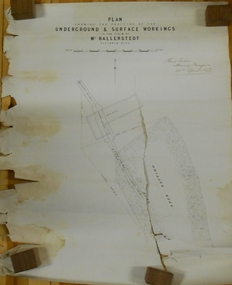
Document - MARKS COLLECTION: GROUND AND SURFACE WORKINGS BALLERSTEDT MINE VICTORIA HILL
Original plan in very poor condition, torn in centre (A copy is listed under No. 8300.36l). On top of plan 'Plan showing the position of the ground and surface workings in the claim of Mr. Ballerstedt Victoria Hill' Plan is signed by Thomas Forbes, Mining Surveyor, 22nd. April 1868. Plan shows house outline and open cut.bendigo, mining, ballerstedt mine victoria hill -
 Bacchus Marsh & District Historical Society
Map, Plan of Survey of Part of Crown Allotment 9, Parish of Korkuperrimul, 1890
This map documents a transfer of an allotment of land in Clarke Street Bacchus Marsh in 1890. Clarke Street is located on the eastern side of Bacchus Marsh not far from Main Street and Crook Street. It is now known as Candeloro Street. The map indicates J. Booth as the owner of the land and H. Simpson as the occupier. Next to this allotment is a an allotment of land owned by J. Elmore,Single page map showing Crown allotment 9, Parish of Korkuperrimul, County of Bourke. Scale 100 feet to inch. Part of a set of maps which are pasted into a bound volume containing 76 maps or plans in total. High resolution digital image stored on BMDHS computer network. At bottom of map: I hereby certify that I have made this survey expressly for the purpose of an application under the Transfer of Land Statute that this plan is correct. Barry B???, Lic. Surveyor, 16.10.90bacchus marsh victoria maps, clarke street bacchus marsh maps -
 Eltham District Historical Society Inc
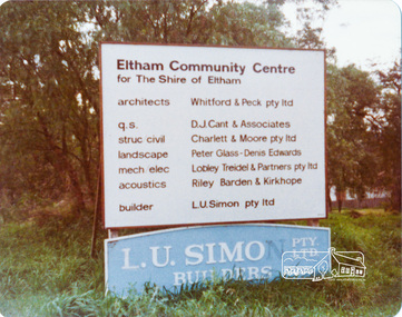
Photograph, Peter Bassett-Smith, Construction of Eltham Community Centre, June 1977, 1977
Building construction sign - Architects: Whitford & Peck Pty Ltd; Quantity Surveyor: D.J. Cant & Associates; Structural Civil Engineers: Charlett & Moore Pty Ltd; Landscape: Peter Glass, Dennis Edwards; Mech Elec: Lobley Treidel & Partners Pty Ltd; Acoustics: Riley Barden & Kirkhope; Builder: L.U. Simon Pty Ltdeltham, eltham community centre, buildings, construction -
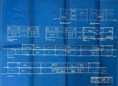 Ringwood and District Historical Society
Document - Architect's Blue Print, 147 Whitehorse Road , Ringwood, Victoria - 1955
Blue print for shopping arcade at 147 Whitehorse Road, Ringwood, for Ringwood Investments Pty. Ltd. Rubber stamped on back and signed off by Borough of Ringwood Building Surveyor 24/5/1955, "Approved subject to Building Regulations and Bye-Laws." Architect for the project was P.E. Jorgensen, Collins House, 360 Collins Street, Melbourne. -
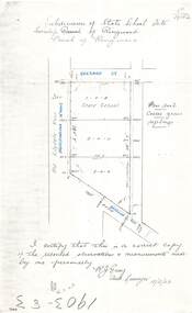 Ringwood and District Historical Society
Document - Copy of Lands Department Field Notes - Subdivision of State School Site, Township of Ringwood, Victoria, Field Notes 1903/83 - Part of O.P. R72C Surveyed 13/2/1903
Foolscap size photocopy of survey map with handwritten notations. References include Everard Street, Old Lilydale Road (Maroondah Highway), Dublin Road, poor soil, coarse grass, saplings, I certify that this is a correct copy of the recorded observations & measurements made by me personally (signed) R.J. Gray Autorised Surveyor 13/2/03. -
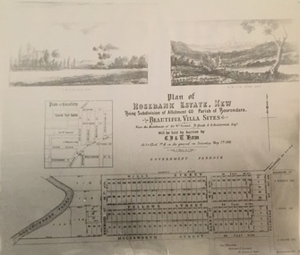 Kew Historical Society Inc
Print - Subdivision Plan, Rosebank Estate, Kew, Nineteenth Century
This work forms part of the collection assembled by the historian Dorothy Rogers, that was donated to the Kew Historical Society by her son John Rogers in 2015. The manuscripts, photographs, maps, and documents were sourced by her from both family and local collections or produced as references for her print publications. Many were directly used by Rogers in writing ‘Lovely Old Homes of Kew’ (1961) and 'A History of Kew' (1973), or the numerous articles on local history that she produced for suburban newspapers. Most of the photographs in the collection include detailed annotations in her hand. The Rogers Collection provides a comprehensive insight into the working habits of a historian in the 1960s and 1970s. Together it forms the largest privately-donated collection within the archives of the Kew Historical Society.A photographic reproduction of a plan in the Vale Collection of the State Library of Victoria. The plan shows the Rosebank Estate in Kew which was offered for sale in 1881. The subdivision was located in Studley Park and included lots in Redmond Street; Fellows Street; Wills Street; Molesworth Street; Barry Street and Princess Street. The surveyor of the subdivision was the local architect George Wharton.rosebank estate (kew), subdivisions -- studley park -- kew (vic.), thomas wills, wills family -
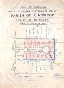 Ringwood and District Historical Society
Map - Plan of Subdivision, Parts of Crown Portions 10 and 10B Parish of Ringwood - 1958
Folded subdivision map of 15 residential allotments in McKay Court Ringwood, off Wantirna Road north of Canterbury Road. Rubber stamped by Surveyors and Chartered Engineers J.S. Watson & Associates, Mornington and South Yarra, with illegible signature dated 17/2/58. Handwritten notations indicating allotment sale names and amounts or where passed in.Scale 80 feet to an inch. -
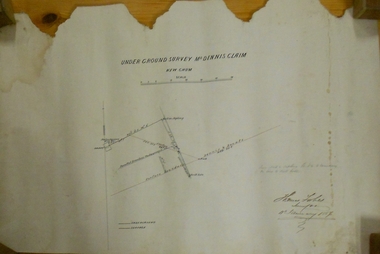 Bendigo Historical Society Inc.
Plan - MARKS COLLECTION: UNDERGROUND SURVEY MR. DENNIS CLAIM NEW CHUM
Plan on heavy parchment paper. On top of plan 'underground survey Mr. Dennis, New Chum' Signed: Thomas Forbes, Surveyor, 11th. January 1867. shows surface boundary of Dennis and Bonati. Written in blue pencil 'From nail in sapling 33f. 51/2 to boundary. Online to drill hole' Shaft marked on LH boundary.'bendigo, mining, mr. dennis claim, new chum -
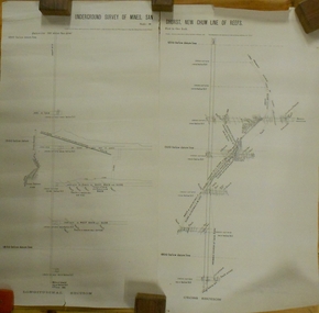 Bendigo Historical Society Inc.
Plan - MARKS COLLECTION: UNDERGROUND SURVEY OF MINES SANDHURST NEW CHUM LINE OF REEF
Plan, divided into two sheets, on top of sheet Underground survey of mines Sandhurst, New Chum Line of Reef. Surveyed by Caleb Thomas under the direction of Charles W. Langtree, Acting Secretary for Mines and Water Supply and Acting Chief Mining Surveyor for the Colony of Victoria. Drawn by Arthur Everett, Mining Department, Melbourne, 1884.bendigo, mining, new chum line of reef -
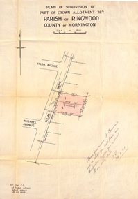 Ringwood and District Historical Society
Document, Plan of Subdivision - Part of Crown Allotment 26A, Parish of Ringwood, County of Mornington - Circa 1961
Map showing layout of 2 allotments coloured red in Velma Grove, adjacent to Valda Avenue and Mirabel Avenue, Ringwood East, Vic.Handwritten notation dated 29/8/1961 by Alf King, Licensed Surveyor, 14 Grace Street, Mont Albert (Phone) WX2020 regarding plans being forwarded to Council for inspection visit. -
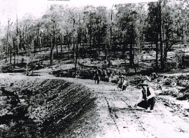 Otway Districts Historical Society
Photograph, Knox Collection, Surveying construction near Barongarook, 1900, 1900
In 1898 a recommendation for a railway of 2 ft 6 in gauge was handed down by the Parliamentary Standing Committee on Railways, to cost $138,000. Construction of the Colac-Beech Forest railway line began in 1900. About 100 men were employed in laying and ballasting the track while others formed the earthworks and the building of culverts and bridges. The earthworks of gravel ballast 150 mm deep were formed by horse and scoop or by shovel. Once the bed had been laid surveyors went along to check the layout, particularly all check rail curves and all 100 metre curves which the surveyors in the picture are doing.B/W. Three men surveying the construction of a curved bed on which track will be laid, near Barongarook, Victoria.colac; beech forest; barongarook; railways; -
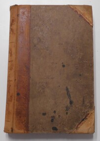
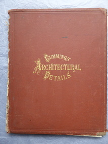 Warrnambool and District Historical Society Inc.
Book, Cummings Architectural Details, 1873
This book was owned by John Crawley, engineer, architect and surveyor. He was appointed District Engineer for the Public Works Department for the Western District in 1866. He was the Shire of Warrnambool Engineer from 1874 to 1895 when he was succeeded by his son.This book is of interest as it contains examples of architectural designs from U.S.A. in the 1870s. Designs such as these influenced the designs of buildings in other countries including Australia. This book is also of interest because of its connection to John Crawley, a member of the Crawley family that had a long and influential association with the Shire of Warrnambool.This is a hard cover book. It has a brown cover with gold lettering. The book has come apart from its binding so many of the pages are loose and the covering on the spine is missing . The front cover is somewhat stained and the edges are worn. The book has many diagrams and illustrations.The inscriptions are handwritten in black ink J. W. Crawley Warrnambool J.W. Crawley 1879john crawley -
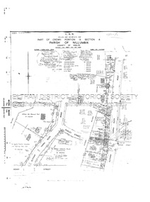
 Eltham District Historical Society Inc
Document - Survey Plan, Country Roads Board, SP 6801, Eltham-Yarra Glen Road; Brougham St to Bridge St, 1958
1958 C.R.B. Plan of Survey of Part of Crown Portion 12 Section 4 Parish of Nillumbik, County of Evelyn Eltham-Yarra Glen Road, Shire of Eltham Shows Surveyor field notes, property ownership and building type and construction.a.j. collis, a.s. & c.g.h. fitzpatrick, board of land & works, bridge street, brougham steet, commonwealth bank of australia, country roads board, eltham, eltham rsl sub-branch, f.h. collis, f.m. smith, f.n. & e.j. burgoyne, franklin street, h.c. & r.e. burgoyne, j. jorgenson, j.f. & j.e. morris, j.n. & h.c. burgoyne, j.s. blow, john street, main road, p.e. smith, pitt street, r.j. dripps, s.j. taylor, survey plan, trustees of the eltham methodist church, 1958, eltham-yarra glen road, neil webster collection -
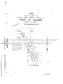 Eltham District Historical Society Inc
Document - Survey Plan, Country Roads Board, SP 6802, Eltham-Yarra Glen Road; Brougham St to Dalton St, 1958
1958 C.R.B. Plan of Survey of Part of Crown Portion 12 Section 4 Parish of Nillumbik, County of Evelyn Eltham-Yarra Glen Road, Shire of Eltham Shows Surveyor field notes, property ownership and building type and construction.1958, eltham-yarra glen road, a.f. munday, bible street, brougham steet, country roads board, dalton street, eltham, j.p. & e.a. sanders, j.w. & e. m. graham, l.c. skipper, l.m. jarrold, main road, napoleon street, survey plan, neil webster collection, franco and co -
 Eltham District Historical Society Inc
Document - Survey Plan, Country Roads Board, SP 6313, Eltham-Yarra Glen Road; Luck St to Henry St, 1956
1956 C.R.B. Plan of Survey of Part of Crown Portion 13 Section 4 Parish of Nillumbik, County of Evelyn Eltham-Yarra Glen Road, Shire of Eltham Shows Surveyor field notes, property ownership and building type and construction.eltham-yarra glen road, country roads board, eltham, main road, survey plan, 1956, a.l. lyon, a.w. brinkkotter, arthur street, c.r. burkett, dudley street, e.n. staff, eltham war memorial trust, henry street, luck street, pryor street, the board of land & works, the equity trustees executors and agency coy ltd, the roman catholic trusts corporation, victorian railways commision, neil webster collection -
 Federation University Historical Collection
Book, Memoirs of the Geological Survey of Victoria No 14 The Ballarat Goldfields, 1923, 1923
William Baragwanath was educated at the Ballarat School of Mines, obtaining a Geology Certificate in 1911. After further study he went on the become Secretary for Mines, and Chief Mining Surveyor. Baragwanath was a Councillor of the Ballarat School of Mine from 1916 to 1950.Pink covered foolscap book of 257 pages and 32 maps and plans by William Baragwanath. Contents include topography, physiography, historical, geology, basalt, faults, dykes, minerals leads, alluvial mines, nuggets, structure of Ballarat West goldfields, structure of Ballarat East gold-field, quartz formation, indicators, defunct mines, existing mines, table of deepest shafts. Images include: section of the Ballarat Gold-Field, Dead HOrse Flat, lakes formed by Basalt Flows, Gong Gong Creek, Frenchman's Lead, Ballarat West Mines, LEases and positions of shafts (1857), puddling, White Horse Lead, Woah Hawp Canton, Ballarat Township mines, Sebastopol, syncline, Victoria United Line, First Chance Mine, Llanberris No 1 Mine, Saddle Reef, New Normanby Mine, Woah Hawp Canton Mine, South Star Mine, Sebastopol Plateau, south Woah Hawp Mine, Woah No. 2 Minegeology, geological survey no 14, ballarat, baragwanath, william baragwanath -
Tatura Irrigation & Wartime Camps Museum
Folder, William Hunter
Presented to Mallacoota& District historical Society by the late Miss Mary Gilbert of Orbost. William Hunter was born in Tatura in 1893. He died in Bairnsdale in 1971. He was a surveyor in Gippsland & Tatura district. He served in WW1 1915 - 1917Silver grey plastic folder. Copy of original held at Mallacoota & District historical society. -
 Friends of Ballarat Botanical Gardens History Group
Photograph - Digital image, Curator's or Caretaker's cottage, unknown
This is the original Caretakers or Curators cottage which was built for the first Botanical Gardens curator, George Longley (1858 - 1899) and his family. George and his family, after being made Gardener, moved to the Surveyors Camp where they lived in a tent. Historic significance associated with original Gardens Curatorb/w view of the Caretakers cottage in the Botanical Gardens showing George Longley, Curator (1858 - 1899) with wife and child.b/w, victorian cottage exterior, young family, curator, george longley -
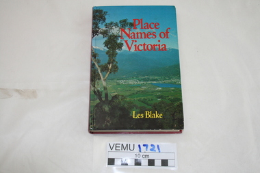 Emerald Museum & Nobelius Heritage Park
Book, Place Names of Victoria, 1977
The sequence of naming was a chronological representative of land discovery and settlement. Starting from the native population to the explorers, the squatters and settlers and surveyors during the gold rush. The term 'places' refers to physical features of the coast and land as well as districts, towns and cities.Hard Cover book written by Les Blake and first published in 1977. The jacket has a photograph of Mount Beauty and the Kiewa Valley from the Tawonga Gap.place names of victoria -
Clunes Museum
Map - PLAN / MAP
.1 MAP, TOWN OF CLUNES, PARISH OF CLUNES, COUNTY OF TALBOT, STAMPED BOROUGH OF CLUNES .2 PLAN OF SUBDIVISION OF PART OF CLUNES COMMON, BOROUGH OF CLUNES, PARISH OF CLUNES,COUNTY OF TALBOT. P. CAMPBELL. ASSISTANT SURVEYOR, MARCH 1904 ON RIGHT HAND BOTTOM CORNER C71/1 CLUNES COMMON. MARKED: CHARTED R.L.A.7/2/57.1 PHOTO LITHOGRAPHED. DEPARTMENT OF LANDS AND SURVEY, MELBOURNE .2 PHOTO LITHOGRAPHED AT THE DEP. OF LANDS AND SURVEY, MELBOURNE PRICE 1/- 10.11.08map town of clunes, borough of clunes, parish of clunes, county of talbot -
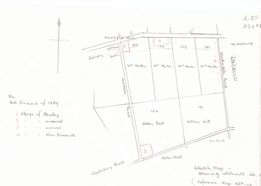 Whitehorse Historical Society Inc.
Document, Subdivisions 1859, nd
Sketch map of subdivisions of 1859.Sketch map of subdivisions of 1859. Allotment 126 and portions of 125, 126 and 130, including 'Village of Studley', 'Village of New Brunswick' and two unnamed. Information from Mr McComb, retired surveyor; sketch and notes. Areas near railway line east of Mitcham Station and North East corner of Canterbury and Mitcham Roads. Refer map A - SP 110.Sketch map of subdivisions of 1859.land subdivision, heatherdale road, mitcham, purches street, mitcham road, vermont, canterbury road, whitehorse road, brunswick road, creek road, centre road, studley village, new brunswick village