Showing 594 items matching " underground"
-
 Federation University Historical Collection
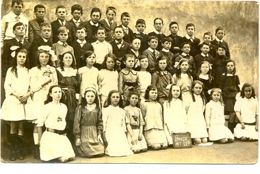
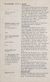
Photograph - Photograph - Sepia, Students of Humffray Street State School No. 34, 1917, 1917 (original) 2112 (digital copy)
Ivy Wilson left Humffray Street State School and as a 12 year old enrolled at the Ballarat School of Mines Technical Art School. She studied Art there from 1920 to 1922. Ivy Wilson later became a successful dressmaker and was able to make her own patterns. Ivy's father was an orthopedic bootmaker. They lived at 17 Mair St. and his shop was an underground section.Sepia photograph showing a number of student of Ballarat's Humffray Street State School Grade Five pupils. The girl kneeling 4th from the right is Ivy Wilson.ballarat school of mines, ballarat technical art school, art, dressmaking, wilson, school, education -
 Port Melbourne Historical & Preservation Society
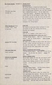
Newspaper - Articles re burst water main in Liardet Street, Port Melbourne, 17 Dec 2014
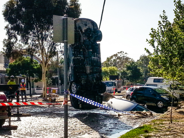
In the early hours of Tuesday 16 December, 2014 a water main burst in Liardet St. The resulting sink-hole swallowed two cars and left a massive hole which took 8 days to repair and re-open the road. Several houses on the city side of Liardet St suffered water damage and water also entered the underground car park of the apartment block on the beach side.Newspaper clipping from "the Age" Wednesday, December 17, 2014. Also from Glen Eira /Port Phillip Leader, Tueday December 23 2014built environment - domestic, engineering - roads streets lanes and footpaths, engineering - canals and drainage, liardet street, water supply -
 Port Melbourne Historical & Preservation Society
Document - Sink-hole, Liardet Street, Port Melbourne, 17 Dec 2014
In the early hours of Tuesday 16 December, 2014 a water main burst in Liardet St. The resulting sink-hole swallowed two cars and left a massive hole which took 8 days to repair and re-open the road. Several houses on the city side of Liardet St suffered water damage and water also entered the underground car park of the apartment block on the beach side.Photos taken of the damage and vehicle recoveries when a sink-hole opened up on Liardet Street on Tuesday 16 December 2014.built environment - domestic, engineering - roads streets lanes and footpaths, engineering - canals and drainage, liardet street, water supply, fran egan -
 Sunbury Family History and Heritage Society Inc.
Photograph, Rosa McCall, 2001
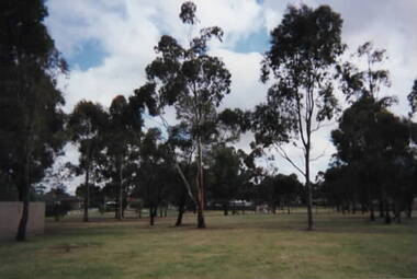
This small park in Sunbury is bounded by Ligar, Miller, Pasley and Neill Streets on the west side of the railway line. There is limited playground equipment in the ground and a plaque acknowledging the work done by nearby resident Roger Free who took on the task as a volunteer caretaker of the park. The area was developed as a park because there is a natural underground spring running diagonally across the land from Ligar Street to Miller Street. This is one of many parks and recreational areas that have been established in Sunbury. A coloured photograph of an open parkland with gum trees growing across the area.roger free, ligar street, neill street, pasley street, miller street, sunbury, parkland -
 Bendigo Historical Society Inc.
Photograph - MINER WALKING ALONG DRIVE AT CENTRAL DEBORAH GOLD MINE, 1951
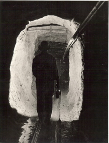
Black and white photograph showing rear view of miner in underground drive illuminated ahead of him by his lamp. Air supply? Lines fixed to upper right of drive. Reflections or light from lamps in background. Inscriptions: on back - in grey lead 'Miner walking along drive at Central Deborah - 1951' On back - TL '42'. TL front '42'.mine, gold, central deborah gold mine, bendigo, mines and mining, individual, person, place, gold mine, mine opening, mining -
 Bendigo Historical Society Inc.
Photograph - HERCULES AND ENERGETIC MINE, 1930's
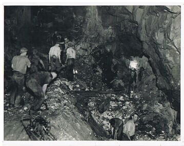
black and white photograph, overhead and underhand stoping 1930's ( James Lerk 26th. November, 1999 ) Note acetylene gas lamps illumination. 'down below' at Bendigo in black lead pencil on rear. ' Hercules and Energetic ' J.J. Stone' in black lead. ' Mine underground working, Bendigo ' Not to be reproduced unless by special permission of the Australian national Travel AssociationAustrralian Nat. Travel ?organization, business, hercules and energetic mine -
Bendigo Historical Society Inc.
Letter - KANGAROO FLAT GOLD MINE COLLECTION: ARVI PARBO, WESTERN MINING CORPORATION
Letter addressed to Sir Arvi Parbo, Western Mining Corporation, Melbourne, from J.M. Lalor, Exploration Manager, Minerals WMC, regarding support sought by the Bendigo Trust to develop an underground tourist mine at Bendigo. J.H Lalor seeks the support of Western Mining,'either by contgributing money or equipment' to develop the Central Deborah Gold mine as a tourist destination.bendigo, gold mining, central deborah gold mine, bendigo, gold mining, tourism, central deborah gold mine, de-watering, western mining corporation., sir arvi parbo, j.m. lalor, daryl mcclure, bendigo trust -
 Bendigo Historical Society Inc.
Newspaper - GOLDEN SQUARE LAUREL STREET P.S. COLLECTION: PHOTOGRAPH - CAGERIDER - THE RIDE OF YOUR LIFE
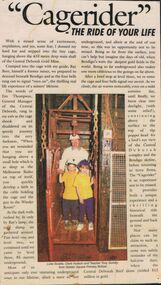
Newspaper cutting glued to a piece of black card and laminated. The title is 'Cagerider' - The Ride of Your Life. The article mentions Golden Square Primary School Teacher Tony Gundry and two children, Luke Scoble and Clare Hudson travelled down to level three, 85 metres underground at the Central Deborah Gold Mine. There is a coloured photo of the teacher and children in the cage.education, primary, golden square laurel st p.s., golden square laurel street p.s. collection - cagerider - the ride of your life, central deborah gold mine, ray beer, jim thompson, melbourne rialto, central deborah reef, luke scoble, clare hudson, tony gundry -
 Bendigo Historical Society Inc.
Photograph - Kangaroo Flat Gold Mine Collection: underground mining machinery, 21st May 1999
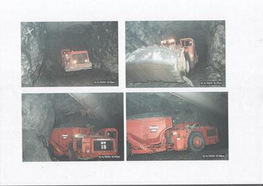
Colour photocopy of original photo. Four separate images showing underground mining machinery working in the Swan Decline, Kangaroo Flat Gold Mine. On one machine (bottom LH corner) 'Tamrock DT 18' visible on side of equipment. Date stamp on all four images is 12/6/2000, between times of 12.35 p.m. to 12.48 p.m.western mining corporation, goldmining, capping, shaft, mining regulations, kangaroo flat gold mine, 2000, swan decline, machinery -
 Kiewa Valley Historical Society
Miners Pick - short
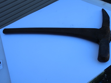
Formerly KV 071. It was used to break up rock and ore, making it easier to extract valuable minerals. The pointed end of the pick axe was used to chip away rock, while the flat end was used to strike the rock for breaking it apart. This one has a short handle. Miners picks were commonly used in the the 19th and early 20th centuries for extracting gold from underground mine tunnels.Used in the Kiewa Valley where prospecting for gold occurred.Formerly KV 071. Cast iron symmetrical pick tool on cast iron with a wooden handle. It has a pointed end and a flat end. It is 12 inches long.gold mining, miners' pick axe, hand tool -
 Robin Boyd Foundation
Document - Script, Robin Boyd, The Flying Dogtor. Episode 16 A Burn in the Blue, 1963
Elvis Eagle, the 'bodgie bird', saved the plane and found The Flying Dogtor lying unconscious on the bank of a river after his frightening trip down an underground tunnel. Meanwhile, back at the Hilltop Hospital, his nurse Sister Spaniel, was still trying to cope with a strange disease that had attacked the bush creatures. Little did she know what awful adventures had befallen The Flying Dogtor.The Flying Dogtor" series was broadcast on Australian Television Network (later becoming the Seven Network) between February and April 1964 (see item D254 for schedule).Typewritten, carbon copy, foolscap, 2 pagesPage 1: handwritten correctionthe flying dogtor, robin boyd, crawford productions, manuscript -
 National Wool Museum
Tool - Water Pump, c.1960
A windmill may be considered one of the most iconic sights of Australian Farming life. A pump like this rest at the heart of all such windmills, turning wind energy into water for farmers both here in Australia and worldwide alike. The water windmills access is referred to as an aquifer, an underground layer of water trapped in rocks but accessible with use of water wells and windmills. Australia is home to an underground aquifer known as the Great Artesian Basin. It is the largest and deepest aquifer in the world. Stretching over 1,700,000 square kilometres, the Basin underlies nearly a quarter of the continent including most of Queensland, the south- east corner of the Northern Territory, the north-east part of South Australia and the northern part of New South Wales. The basin is 3,000 metres deep in places and is estimated to contain 64,900 cubic kilometres of groundwater. To try and give this number context, a megalitre is a million litres. The Great Artesian Basin contains 65,000 million megalitres of water. This would be enough to cover all the land on the planet in almost half a metre of water.Lift style piston pump typical of an Australian farm connected to a multi-bladed windmill. Bronze cylindrical construction coming up from removable wood base. Rotating lever is above outlet pipe which would send water to the storage tank.windmill, australian farming, great artesian basin, aquifer -
Bendigo Historical Society Inc.
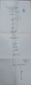
Document - Mine Managers, a glimpse at a large subject. From Ballerstedt to Buerger
Mine managers had a variety of roles. They were a go-between for investors or shareholders and were responsible for the effective utilisation of human and physical resources above and underground. From the early 1870's the Bendigo school of mines held courses and exams leading to a Mine Manager's Certificate. These certificates were awarded in 3 classifications:- 1st class certificate holders could manage any mine where large and expensive machinery was used. They needed knowledge and competence in areas such as surveying, underground plan drawing, ventilation, amalgamation, retorting and smelting. They must also be literate and numerate. 2nd Class:- able to manage any mine where steam machinery was in use. 3rd Class:- for mines where there was no steam machinery . They needed to have a good knowledge of whim, whip or windlass work. Conversations continued through to the 1920's about whether the requirement for a Managers Certificate should be made compulsory under amendment to the Mines Act 1883. There were also discussions of the minimum amount of mine experience applicants should possess.A research paper detailing the history of managers and their role in the Bendigo gold fields. A short address prepared by James A. Lerk April/ May 2002. 8 pages.mine managers, ballerstedt, buerger -
 Melbourne Tram Museum
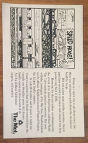
Poster, The Met, "Speed Hogs", May. 1984
Advertising Poster for use in Tramcars printed on heavy cardboard - titled "Speed Hogs" about the opening of the final section of the Underground loop or City Loop - has a cartoon by "Jeff" - notes the connection of the north western lines - 1 May 1984 (PTV Website loop history accessed 7-2-2016) Has The Met logo in the bottom right hand corner.trams, tramways, the met, city loop, melbourne -
 Bendigo Historical Society Inc.
Document - LONG GULLY HISTORY GROUP COLLECTION: LETTERS FROM THE LONG GULLY HISTORY GROUP
Letter dated 7th May 2002 to Councillor Willi Carney from George Ellis, Long Gully History Group requesting the council to consider the site in their original application for the marker to acknowledge the achievement of underground mining Linear Park Long Gully. The allocated site is unsuitable as the ground is unstable and work to stabilise the ground to stop it from tipping could double the cost.bendigo, history, long gully history group, the long gully history group - letters from the long gully history group, councillor willi carney, city of greater bendigo, george ellis -
 Glenelg Shire Council Cultural Collection
Photograph - Photograph - Battery Point, Portland, c. 1983
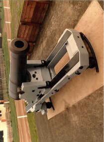
Glenelg Shire Council records. Built on land gazetted for defence purposes in the 1840s, Portland Battery was constructed in 1889 to defend Victoria against the feared Russian invasion. Batteries were also constructed at Warrnambool and Port Fairy during this period. The Battery comprises a magazine, upper chamber, a parapet wall, and three gun emplacements. In 1984 the Battery underwent a major restoration. The underground magazine and lamp passage are currently not accessible to the public.Picture of Cannon, Low Moore 68 lb, 1861, Battery Point, South Portland.portland battery, cannon, munition, fortifications, magazine, 1800s -
 Robin Boyd Foundation
Document - Script, Robin Boyd, The Flying Dogtor. Episode 14 The Cave, 1963
The Flying Dogtor, tricked by Crafty Carson Carpetbag into falling into an old mineshaft, wandered into an underground limestone cave and then slipped into a subterranean river. He was swept into a long dark tunnel. Meanwhile, high above him, Crafty tried to fly the Dogtor's plane away. He couldn't control it and the plane shot up into the sky without him, rolling over and over without a pilot, without its master, The Flying Dogtor.The Flying Dogtor" series was broadcast on Australian Television Network (later becoming the Seven Network) between February and April 1964 (see item D254 for schedule).Typewritten, carbon copy, foolscap, 2 pagesPages 1 & 2: handwritten corrections on both pagesthe flying dogtor, robin boyd, crawford productions, manuscript -
 Robin Boyd Foundation
Document - Script, Robin Boyd, The Flying Dogtor. Episode 15 Strange Spots, 1963
The Flying Dogtor fell into an underground river and was swept away by the current. At the same time his plane was set loose by Crafty Carson Carpetbag and was circling wildly without a pilot, high in the outback sky. Meanwhile, back at the Dogtor's base, the Hilltop Hospital, his poor nurse Sister Spaniel, was driven almost frantic trying to cope alone with a strange epidemic of spots that was sweeping the bush. She desperately needed The Flying Dogtor.The Flying Dogtor" series was broadcast on Australian Television Network (later becoming the Seven Network) between February and April 1964 (see item D254 for schedule).Typewritten, carbon copy, foolscap, 3 pagesthe flying dogtor, robin boyd, crawford productions, manuscript -
 Robin Boyd Foundation
Document - Script, Robin Boyd, The Flying Dogtor. Episode 49 The Serpent Net, 1963
The Flying Dogtor, helping solve the mystery of a monster or sea serpent that was wandering the lakes and tunnels of the Snowy Mountains Scheme, noticed strange things happening: a speedboat driven by a snakey-looking person and a lookout tower operated by spiders, it seemed... Later, a plan to trap the serpent in an underground tunnel was arranged by The Flying Dogtor. He asked for several things: a team of fisherman; a large fishing net; two fast fishing boats; and an enormous canvas bag.The Flying Dogtor" series was broadcast on Australian Television Network (later becoming the Seven Network) between February and April 1964 (see item D254 for schedule).Typewritten, carbon copy, foolscap, 2 pagesHandwritten pencil edits and additions.the flying dogtor, robin boyd, crawford productions, manuscript -
 Puffing Billy Railway
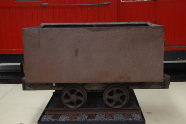
Wonthaggi Coal Skip, Early 20th century
One of two types of four wheel skips widely used on the Wonthaggi Coal Fields for transportation from the underground workings to the surface screening and loading areas. Haulage underground was accomplished by the use of pit ponies, whilst an endless rope system was used to bring the skips to the surface areas. Much of the coal for the colony of Victoria was sourced from Newcastle and the Hunter Region in New South Wales, along with local supplies from private and co-operative coal mines at Outtrim, Jumbunna and Korumburra in Gippsland. After the 1909–1910 strike by coal miners in the Hunter Valley, the Victorian state government were determined to ensure stability in local supplies of coal. The State Coal Mine and the town of Wonthaggi came into being in 1910 to supply coal for the Victorian Railways. It was one of the largest and most dangerous collieries in Australia. At its peak in 1926 the mine produced 2,435 long tons (2,474 t) per day, with the Victorian Railways buying 90% of production. In 1928, Wonthaggi coal accounted for around 60% of Victorian Railways coal consumption.Historic - Industrial - Victorian Railways - Narrow Gauge Railway rolling stock - Wonthaggi Coal Fields, Victoria, AustraliaRectangular steel bin with wood frame and steel wheelspuffing billy, coal skip, wonthaggi, wonthaggi coal fields, 2'0" gauge, brown coal -
 Bendigo Historical Society Inc.
Map - HUSTLER'S CONSOLS MINE - TRANSVERSE SECTION OF THE HUSTLER'S CONSOLS MINE
Transverse Section of the Hustler's Consols Mine Bulletin No 33, Plate No XXXIII. Map shows poppet legs at the surface and Sill of Shaft 779.42 feet above Sea Level. Shows the different levels and their depths and the different stone and geographical features encountered. Has larger drawing of Section A - B. Geographical Survey of Victoria. Signed by H A Whitelaw, Underground Survey Office Bendigo, September 1913. mining, parish map, hustler's consols mine, transverse section of the hustler's consols mine, geological survey of victoria, underground survey office bendigo, h a whitelaw -
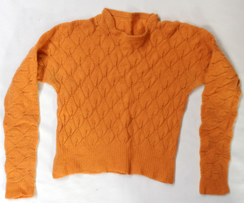 Orbost & District Historical Society
knitted jumper, 1938-1940
This was knitted by Marjorie Burton during WW11 in England. She used to knit while in an air raid shelter escaping the bombing with her young daughter. Air raid shelters were built specifically to serve as protection against enemy air raids. However, pre-existing structures such as underground stations (tube or subway stations), tunnels, cellars in houses or basements in larger establishments, and railway arches, above ground, were suitable for safeguarding people during air raids. This item is an example of a handcrafted item and reflects the handcraft skills of women necessary during WW11 when clothing became scarce. Clothes rationing began on June 1, 1941, two years after food rationing started. Clothes rationing ended on 15 March 1949.A hand-knitted orange/tan woolen jumper. It is a lady's long-sleeved jumper.handcraft knitting ww11 -
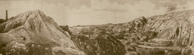 Ballarat Heritage Services
Photograph - Image - Black and White, Old Works, Black Hill Gully, Ballarat, c1904, c1904
The first company to make a success of hard-rock (quartz) gold mining at Black Hill was the Black Hill Company, formed in 1859. Mining from the open-cut mine probably commenced in 1860 and by 1861 the company had erected the largest stamping mill in Victoria. The mill ran 24 hours a day until the end of 1864 and 12 hours a day in 1865. Open cut mining then ceased. Underground ore extraction continued at Black Hill until the early twentieth century.Photographic image of the abandoned open-cut mine at Black Hill, Ballarat, c1904 ballarat, black hill, mining, open cut, gold -
Surrey Hills Historical Society Collection
Work on paper - Vertical file on Back Creek, Surrey Hills
Back Creek is one of the tributaries of Gardiners Creek. It rises as a spring on the slopes of the hill at the corner of Canterbury Road and Elgar Road in Surrey Hills, the location of a Melbourne Water tower and reservoir. It has been channelled underground from this point in pipes as far as Union Road. South Surrey Park runs along both sides of Back Creek from where the creek crosses Union Rd near Rose Avenue to where it crosses Riversdale Road just west of Through Road. A vertical file containing information about Back Creek in Surrey Hills: 1. 4 colour photos taken in 1983 (1 page). 2. ‘Pipe dreams run their course’, (Boroondara Review ?) 17.4.2013 (1 page). 3. ‘Plan rainchecked for creek impact’, Boroondara Review, 13.3.2013 (2 pages). back creek -
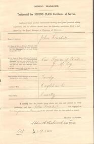 Bendigo Historical Society Inc.
Document - TESTIMONIAL JOHN LONSDALE
Two testimonial issued October 17th 1914 to John Lonsdale. One handwritten by the New prince of Wale mine manager certifying that John Lonsdale had been working under ground for seven years and that he has thorough knowledge of mining. The second a testimonial for Second Class Certificate of service certifying that John Lonsdale hs performed the duties of underground foreman at the New Prince of Wales mine in Eaglehawk.person, certificate, john lonsdale -
 Bendigo Historical Society Inc.
Photograph - BILL ASHMAN COLLECTION: SCALEBUOY
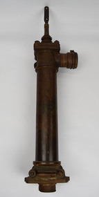
White envelope with typed address to Mr. F. A. Stevenson,244 Hargreaves Street, Bendigo. Victoria. Has 3 1/2d red stamp attached. Contained 3 photos of a Scalebuoy set up outside a building. The Scalebuoy is set up on two blocks of wood and has 3 pipes attached to it. There is also a pipe coming out of the ground on one end and returning underground on the other end.sciences, instruments - general, scalebuoy, bill ashman collection - correspondence, f a stevenson, scalebuoy -
 Bendigo Historical Society Inc.
Photograph - LONG GULLY HISTORY GROUP COLLECTION: THE BENDIGO UNDERGROUND MINER
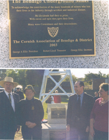
Copy of two photos on the page. The top one is a photo of the plaque with: The Bendigo Underground Miner. To acknowledge the contribution of the many hundreds of miners who lost their lives in the industry through accident and industrial disease. Many were Cornishmen and their descendants. The lower photo shows part of the poppet head with the plaque and another one below it. There are two men standing on one side of the plaques and a lady and a man on the other side.bendigo, history, long gully history group, the long gully history group - the bendigo underground miner, teh cornish association of bendigo & district, george a ellis, robert lloyd -
 Ballarat Tramway Museum
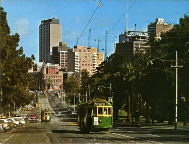
Postcard, Murfett Pty Ltd, Wellington Parade, East Melbourne
Colour postcard of Wellington Parade, East Melbourne with Melbourne skyline in background and Fitzroy Gardens in background. Would appear works for the underground are in progress. Has W2 509, outbound on route 29 to 'Kew Depot' and a tram (wide body car) in bound on route 74. Has on rear caption, "National View" by Murfett Pty Ltd. Australia, place for address and stamp. Taken early 70's.trams, tramways, melbourne, wellington parade, postcards, tram 484, tram 229, tram 364 -
 Ballarat Tramway Museum
Administrative record - Memorandum, State Electricity Commission of Victoria (SECV), "Bendigo Tramways - Disposal to Bendigo Trust", 23/12/1991 12:00:00 AM
Photocopy of an A4 sheet, State Electricity Commission Memorandum dated 23 December 1991, concerning the transfer of the remaining SEC assets to the Bendigo Trust. Proposed to transfer track, overhead, underground cables, electrolysis drain equipment and some poles. Gave a background to the original equipment and asset distribution when the Bendigo Trust was formed and subsequent events. From the Manager Northern Region to General Manger Customer Services.trams, tramways, bendigo, sec, bendigo trust -
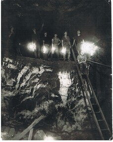 Bendigo Historical Society Inc.
Photograph - HERCULES AND ENERGETIC MINE, 1939
black and white photo of underground mining, showing 8 miners in a stope with their Bendigo bucket carbide lights. A large quartz spur formation is visible in the foreground. A wooden ladder gives a good scale in relation to the stope size. Photograph taken in the Central Nell Gwynne at the 265 m. level C 1939. On back MNc4 ( in indian ink ) ? Hercules and Energetic ( in ball point pen ) RHSV of Vic. Stamp.organization, business, hercules and energetic mine