Showing 6915 items
matching view street
-
 Ringwood and District Historical Society
Photograph, Maroondah Highway West, Ringwood- c1973. Westward view from Ringwood Street/Wantirna Road
... Maroondah Highway West, Ringwood- c1973. Westward view from.... Westward view from Ringwood Street/Wantirna Road. Photograph ...Black and white photographWritten on rear of backing sheet: " Main Street looking West from Ringwood Street, 1973. -
 Eltham District Historical Society Inc
Photograph, Fred Mitchell, View of Taylor Street from front yard of 86 Bible street, Eltham, 1966, 1966
... View of Taylor Street from front yard of 86 Bible street... streets Digital copy of colour photograph View of Taylor Street ...Digital copy of colour photographfred mitchell collection, 1966, bible street, taylor street, streets -
 Eltham District Historical Society Inc
Photograph, Fred Mitchell, View of Henry Street from front yard of 86 Bible street, Eltham, 1966, 1966
... View of Henry Street from front yard of 86 Bible street... street Digital copy of colour photograph View of Henry Street ...Digital copy of colour photographfred mitchell collection, 1966, bible street, streets, henry street -
 Victorian Interpretive Projects Inc.
Photograph - Colour, Clare Gervasoni, View from Armstrong Street South, Ballarat, towards Mt Warrenheip
... View from Armstrong Street South, Ballarat, towards Mt..., Ballarat, looking towards Mt Warrenheip. View from Armstrong Street ...A changing array of images taken from the same place in Armstrong Street South, Ballarat, looking towards Mt Warrenheip.ballarat, ballarat east -
 Nillumbik Historical Society Incorporated
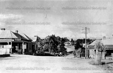
Photograph - Black & white photograph, View of Main Street towards Cowin Street, Diamond Creek c1920
... View of Main Street towards Cowin Street, Diamond Creek... Square Diamond Creek melbourne Black & white photograph View ...Black & white photograph -
 Nillumbik Historical Society Incorporated
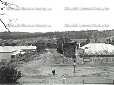
Photograph - Black & white photograph, View Down Chute Street Diamond Creek with Man and Two Dogs c1910
... View Down Chute Street Diamond Creek with Man and Two Dogs... creek Black & white photograph View Down Chute Street Diamond ...Black & white photographnillumbik, chute street, diamond creek -
 City of Ballarat Libraries
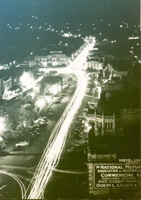
Photograph, View of Sturt Street during Ballarat Centenary Celebrations looking east at night circa 1938
... View of Sturt Street during Ballarat Centenary Celebrations... street centenary national mutual ballarat traffic View of Sturt ...A night scene on Sturt Street looking east at night during the Centenary Celebrations in 1938. The dome on the National Mutual Building can be seen in the foreground.sturt street, centenary, national mutual, ballarat, traffic -
 City of Ballarat Libraries
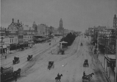
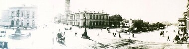
Photograph, Panorama view of Sturt Street circa 1870
... Panorama view of Sturt Street circa 1870.... Panorama view of Sturt Street circa 1870. Photograph Photograph ...This view is from the Post Office tower looking south. Things of interest include the Town Hall, the Burke & Wills Monument, Cobbs Corner and the Mechanics' Institute.panorama, commerical, public, building, gadens, sturt street, streetscape -
 City of Ballarat Libraries
Photograph, Western view along Sturt Street from Grenville Street 1899
... Western view along Sturt Street from Grenville Street 1899.... gardens trams horses ballarat Western view along Sturt Street from ...Looking west from Grenville Street along Sturt Street. A Horse Drawn Tram can be seen along with the Rotunda.sturt street, grenville street, streetscape, commerical, gardens, trams, horses, ballarat -
 City of Ballarat Libraries
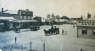
Postcard - Card Box Photographs, View of Neill Street, Beaufort circa 1900
... View of Neill Street, Beaufort circa 1900.... Beaufort Hotel Commerical Vehicle View of Neill Street, Beaufort ...Some of the businesses along the street include the Beaufort Hotel, hardware store, bakery and a general store that sells the Argus. beaufort, neill street, postcard, beaufort hotel, commerical, vehicle -
 City of Ballarat Libraries
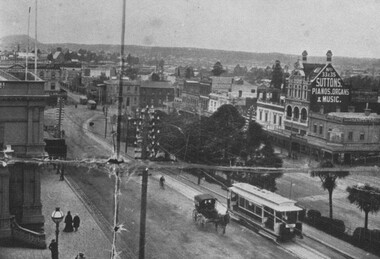
Photograph - Card Box Photographs, South East view over Sturt Street, Ballarat circa 1905. From Star 1855-1905 Jubilee publication
... South East view over Sturt Street, Ballarat circa 1905... Vehicle Trams Commerical Public South East view over Sturt Street ...Photo taken from the Post Office tower. Both horse drawn carts and electric trams can be seen. Advertising for Suttons Pianos, Organs & Music dominates the scene.sturt street, ballarat post office, streetscape, suttons, garden, vehicle, trams, commerical, public -
 City of Ballarat Libraries
Photograph - Card Box Photographs, South East view over Sturt Street, Ballarat circa 1905. From Star 1855-1905 Jubilee publication
... South East view over Sturt Street, Ballarat circa 1905... Vehicle South East view over Sturt Street, Ballarat circa 1905 ...This photo was taken from Doveton Street North looking down Sturt Street to the south east.sturt street, doveton street north, streetscape, gardens, commerical, public, trams, vehicle -
 City of Ballarat Libraries
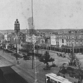
Photograph - Card Box Photographs, Panorama view of Sturt Street, Ballarat circa 1903
... Panorama view of Sturt Street, Ballarat circa 1903.... Building Vehicle Panorama view of Sturt Street, Ballarat circa 1903 ...The view to the north east from the corner of Lydiard Street North and Sturt Street. Featured in the photo is the Burke & Wills Monument, the Robbie Burns statue and the Camp Hill Gardens.panorama, sturt street, lydiard street north, burke & wills monument, robbie burns statue, camp hill gardens, streetscape, building, vehicle -
 Inverloch Historical Society
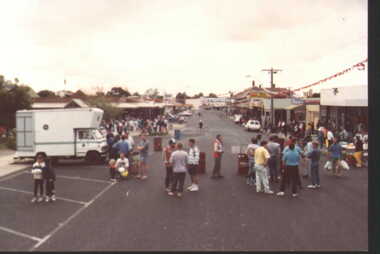
001066 - Photograph - January 1992 - Inverloch - Fun Run and view down A'Beckett Street - from Eileen Henderson
... and view down A'Beckett Street - from Eileen Henderson... - Fun Run and view down A'Beckett Street - from Eileen Henderson ... -
 Mt Dandenong & District Historical Society Inc.
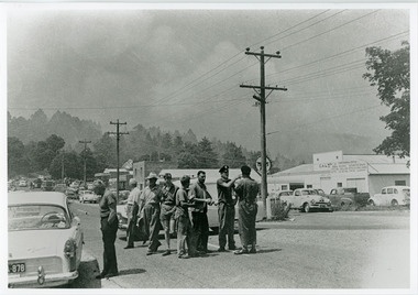
Photograph, Street view Mt Dandenong during 1962 bushfires, 1962
... Street view Mt Dandenong during 1962 bushfires... clearly visible. Street view Mt Dandenong during 1962 bushfires ...Taken during the 1962 bushfires. View of Mount Dandenong shops opposite the Hotel with garage to the right. 8 men in foreground with smoke clearly visible.mount dandenong, mt dandenong road, bushfire -
 Department of Health and Human Services
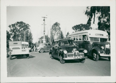
Photograph, To the right of the photo is a 1943/44 Grummet bodied Ford (thanks to identification by the Bus & Coach Society Victoria). Centre of the photo is one of the first Holden sedans, built in 1948 - the street view backdrop is the entrance to Gresswell Sanitorium - Mont Park
... 1948 - the street view backdrop is the entrance to Gresswell..., built in 1948 - the street view backdrop is the entrance ... -
 Department of Health and Human Services
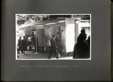
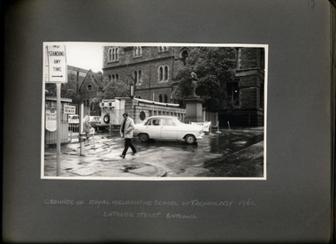
Photograph, A street view of the chest x-ray caravan, with a qeue, operating outside of Centreway Collin St in 1962 - 2 of 3 Photos - Department of Health - Tuberculosis Branch - Publicity material
... A street view of the chest x-ray caravan, with a qeue... Melbourne melbourne A street view of the chest x-ray caravan ... -
 Department of Health and Human Services
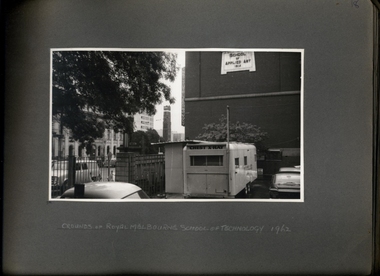
Photograph, A street view of the chest x-ray caravan operating in the grounds of RMIT Melbourne in 1962 - 2 of 3 Photos - Department of Health - Tuberculosis Branch - Publicity material
... A street view of the chest x-ray caravan operating in the... Melbourne melbourne A street view of the chest x-ray caravan ... -
 Department of Health and Human Services
Photograph, A street view of the chest x-ray caravan operating in the grounds of RMIT Melbourne in 1962 - 3 of 3 Photos - Department of Health - Tuberculosis Branch - Publicity material
... A street view of the chest x-ray caravan operating in the... Melbourne melbourne A street view of the chest x-ray caravan ... -
 Kew Historical Society Inc
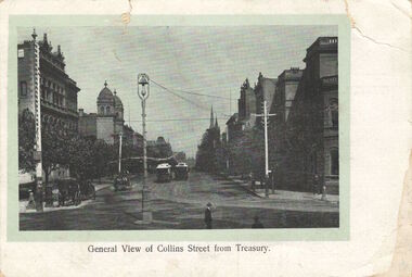
Postcard, General View of Collins Street from Treasury, 1920-1950
... General View of Collins Street from Treasury... Street, Melbourne looking west. General View of Collins Street ...This work forms part of the collection assembled by the historian Dorothy Rogers, that was donated to the Kew Historical Society by her son John Rogers in 2015. The manuscripts, photographs, maps, and documents were sourced by her from both family and local collections or produced as references for her print publications. Many were directly used by Rogers in writing ‘Lovely Old Homes of Kew’ (1961) and 'A History of Kew' (1973), or the numerous articles on local history that she produced for suburban newspapers. Most of the photographs in the collection include detailed annotations in her hand. The Rogers Collection provides a comprehensive insight into the working habits of a historian in the 1960s and 1970s. Together it forms the largest privately-donated collection within the archives of the Kew Historical Society.Collins Street, Melbourne looking west.collins street, melbourne, dorothy rogers, postcards - melbourne -
 Kew Historical Society Inc
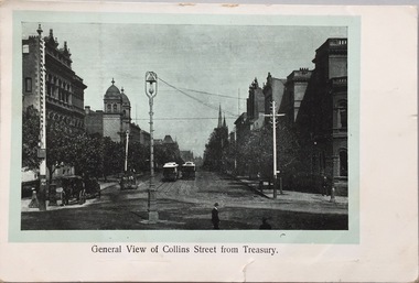
Postcard, General View of Collins Street From Treasury, 1907-1915
... General View of Collins Street From Treasury... from Spring Street. General View of Collins Street From ...The Kew Historical Society's postcard collection includes views of Kew, Melbourne and Greater Melbourne as well as those including overseas scenes sent or received from Europe or the Middle East. They date from the 1890s to the 2000s. These postcards may or may not include the name of the publisher or printer. A number of the cards were published as parts of popular series. A way of dating early postcards is to identify whether the reverse was divided by a central line which became the norm after 1902 in the United Kingdom. However, other postcards produced after this date do not always conform to this print layout.The item forms part of the Laurie Bennett collection of thirty-six postcards and photographs of Kew and early Melbourne, donated to the Kew Historical Society in 1980. The postcards in the Bennett collection, like other images in the Society's holdings date from the 1890s to the present and comprehensively indicate points-of-view or scenes considered historically, aesthetically or socially significant in the period in which they were produced.Postcard depicting Collins Street looking west from Spring Street. Reg-No-KH.392 (obsolete number). Donated by L. Bennettcollins street -- melbourne (vic.), postcards -
 Stawell Historical Society Inc
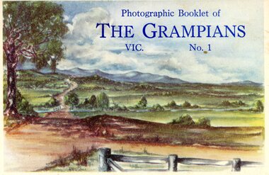
Postcard, Front Cover of Stawell Photographic Booklet & a Postcard view of Main Street Stawell -- 2 Photos -- Postcard -- Coloured
... view of Main Street Stawell -- 2 Photos -- Postcard -- Coloured... Photographic Booklet & a Postcard view of Main Street Stawell -- 2 ...Main Street Stawell looking West c1930s. George Mitchell Store on rightstawell streetscape -
 Stawell Historical Society Inc
Archive - CD/DVD, Glenorchy Images (2) Glenorchy Historic Sites. Glenorchy, Footbridge, Four Posts Inn, Royal Mail Hotel, School, Street View, Wimmera River, Football Team, Railway Station, Cook& Sons Saddlers, Chas Lea Fruiterer, London Bank plus short histories, 2013/2014
... , Footbridge, Four Posts Inn, Royal Mail Hotel, School, Street View..., Royal Mail Hotel, School, Street View, Wimmera River, Football ...stawell, glenorchy, streetscape -
 Surrey Hills Historical Society Collection
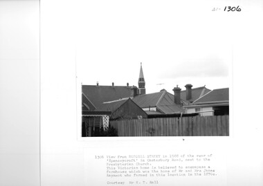
Photograph, View from Russell Street, of the rear 'Spencecroft' in 1988
... View from Russell Street, of the rear 'Spencecroft' in 1988... Street, at the rear of 'Spencecroft'. View from Russell Street ...Spenceycroft was home of James and Elizabeth Rayment, who had a dairy farm in the area in the 1870s. The house was located in Canterbury Road next to the Surrey Hills Presbyterian Church. For many years, it was hidden behind a large fence sheltering it from the noise of traffic along Canterbury Road. It has been claimed that it incorporated part of the original farmhouse built on the site by George Klepper, who planted a vineyard in the area. George’s family was one of a number of German families who settled in Surrey Hills during the later part of the 19th century. In recent years Spenceycroft was sold several times and became increasingly derelict. Since its last sale, it has been demolished. Some of the above may be in error. Research is currently being undertaken to authenticate claims previously asserted.A black and white photograph of the rear of some buildings from Russell Street, at the rear of 'Spencecroft'.house names, spenceycroft, spencecroft, russell street, surrey hills, james rayment, (mrs) elizabeth rayment -
 Surrey Hills Historical Society Collection
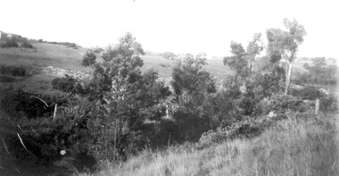
Photograph, View from Goodwood Street, Surrey Hills in 1930, 1930
... View from Goodwood Street, Surrey Hills in 1930... of a large family. He married Olive Mary Romey. goodwood street ...The Breeden family came to Surrey Hills in 1905, first to Guildford Road, then Middlesex Road where Horrie Breeden lived as a boy. He sometimes used to help with milking at the adjoining Kenneally's dairy in Highfield Road. Sometimes he and his brother drove the cows from there to Schneider's property near Florence Road on the way to Surrey Hills Primary School. The cows would graze here until the boys took them back after school. At other times he would deliver milk from the Croydon Road dairy (Isherwood's or Bovill's) to St Joseph's Boys Home before school. Horrie became an apprentice in woodwork / carpentry at Vine's timber yard before serving in World War 1. Horrie's father died in 1919 and in the same year he bought 3 cows and established his own dairy on his mother's property on the corner of Goodwood Street and Boisdale Road. In the 1920s Horrie built the first house in Goodwood Street. He went on to build others in the street including his own at No 7 Goodwood Street. He did all the joinery and internal fittings for this. [REF: Oral testimony: Horrie Breeden to Jocelyn Hall in 1979.] In the 1990s the owner of 7 Goodwood Street discovered a branding iron under the house; this is presumed to relate to Horrie Breeden's dairy. It was donated to SHNC's collection. Horrace Bruce Breeden (7 July 1898-24 January 1988) was son of Charles Henry Breeden and Lavinia Maria Darby, both born Warwickshire; buried in Box Hill Cemetery. He was one of a large family. He married Olive Mary Romey.Black and white photo taken from the east end of Goodwood Street, Surrey Hills in 1930, looking towards Elgar and Riversdale Roads. It shows an area which is rural in appearance. It is not built upon. The foreground is grassy and there is a post-and-wire fence to the right. There is a bank of eucalyptus trees behind which is hilly grassland.goodwood street, dairies, horace breeden, horrie breeden -
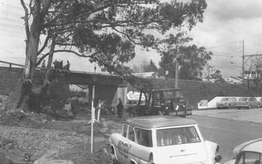
 Ringwood and District Historical Society
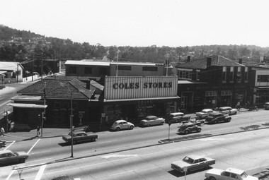
Photograph, Maroondah Highway Central, Ringwood. Clocktower view of Ringwood Street and Maroondah Highway corner, 1969
... Maroondah Highway Central, Ringwood. Clocktower view of...Image shows Post Office on corner of Ringwood Street, Coles ...Black and white photographImage shows Post Office on corner of Ringwood Street, Coles Stores, and State Savings Bank. -
 Linton and District Historical Society Inc
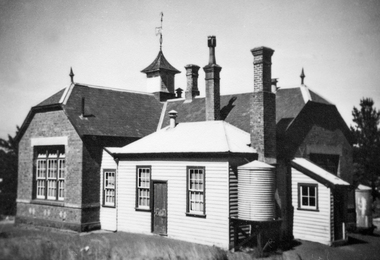
Photograph, Linton State School No. 880, View from Grant Street
... Linton State School No. 880, View from Grant Street... School No. 880, View from Grant Street Photograph ...Linton State School No. 880 was established in 1867, although it is understood that the building was not completed until about 1873.Black and white photograph showing a brick building with several chimneys, and a timber addition, understood to have originally been built as head teacher living quarters.On back of mount: "LINTON STATE SCHOOL NO 880 BUILT 1873" / "facing Grant Street".linton state school no. 880, buildings -
 Linton and District Historical Society Inc
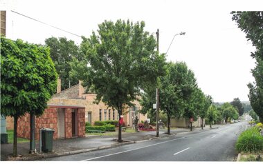
Photograph, View along Sussex Street to the North, Linton, 2014
... View along Sussex Street to the North, Linton, 2014... and buildings in Sussex Street, Linton, the Linton public toilet ...The public toilet block in Linton is decorated with hand-made terracotta tiles depicting historic themes. The tiles were produced as part of the Press Mould Tile Project 2001-2002 by Linton Primary School students and community members. Tile design and project coordination was by Pam Farey and Anne Dietrich, and instructors were Pam Farey, Anne Dietrich, Anne Bray and Jeannette Vervaart. The site the toilet block was built on was formerly occupied by 'Criterion House', a building used in the 19th and early 20th centuries as a shop and also a hospital. Criterion House was demolished in 1938/39, to make way for new, enlarged municipal offices, which are still in use in 2019.Colour photograph which shows trees and buildings in Sussex Street, Linton, the Linton public toilet building, and the Golden Plains Shire local offices.golden plains shire offices linton, public toilet building linton, press mould tile project 2001-2002 -
 Federation University Historical Collection
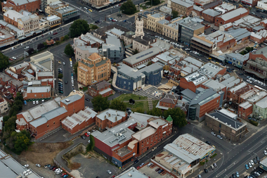
Photograph, Aerial View of Camp Street, Ballarat
... Aerial View of Camp Street, Ballarat... Former Ballarat Courthouse Aerial View of Camp Street, Ballarat ...camp street, arts academy, deakin place, alfred deakin place, art gallery of ballarat, ballarat state officers, former ballarat library, ballarat trades hall, george hotel, regent theatre, former ballarat courthouse -
 Ballarat Tramway Museum
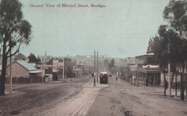
Postcard, WTP, "General view of Mitchell Street Bendigo", 1910s
... "General view of Mitchell Street Bendigo"... - colour divided back, unused. "General view of Mitchell Street ...The photograph shows a Bendigo ESCo tram climbing the hill in Mitchell St to where the double track converged into a single track before crossing over the railway line. The photo is looking west. Has a two-storey hotel on the right. See item 8452 for a black-and-white version.Yields information about Mitchell St Bendigo and ESCo trams.Postcard - colour divided back, unused.tramways, trams, bendigo, mitchell st