Showing 831 items matching "1890s"
-
 Kew Historical Society Inc
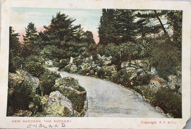
Postcard, Kew Gardens, The Rockery, 1902-1912
The Kew Historical Society's postcard collection includes views of Kew, Melbourne and Greater Melbourne as well as those including overseas scenes sent or received from Europe or the Middle East. They date from the 1890s to the 2000s. These postcards may or may not include the name of the publisher or printer. A number of the cards were published as parts of popular series. A way of dating early postcards is to identify whether the reverse was divided by a central line which became the norm after 1902 in the United Kingdom. However, other postcards produced after this date do not always conform to this print layout.Colour postcard of the Rockery, in Kew Gardens, London. Front - Kew Gardens, The Rockery / Copyright F.F. & Co. Reverse - POST CARD / FOR INLAND POSTAGE THIS SPACE, AS WELL AS THE BACK, MAY NOW BE USED FOR COMMUNICATION. FOR FOREIGN POSTAGE THE BACK ONLY (Post Office Regulation) /THE ADDRESS ONLY TO BE WRITTEN HERE. Dear Henry. Many thanks for Birthday greetings received today the first one to remember me. Hope you are well as this leaves all. Thi sis the only postcard in Sea Lake so excuse. No more just now with kind regards from Estherpostcards -- uk, postcards -- kew gardens, kew gardens -- the rockery -
 Kew Historical Society Inc
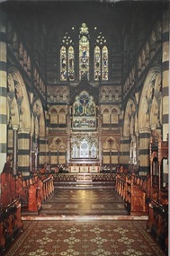
Postcard, Paul Ahearne, St Paul's Cathedral, Sanctuary, 1950-1965
The Kew Historical Society's postcard collection includes views of Kew, Melbourne and Greater Melbourne as well as those including overseas scenes sent or received from Europe or the Middle East. They date from the 1890s to the 2000s. These postcards may or may not include the name of the publisher or printer. A number of the cards were published as parts of popular series. A way of dating early postcards is to identify whether the reverse was divided by a central line which became the norm after 1902 in the United Kingdom. However, other postcards produced after this date do not always conform to this print layout.Colour postcard of the interior of St Paul's Cathedral, Melbourne by Max Ahearne, Renwick Pride, Gravure Print.St Paul's Cathedral, Melbourne, Australia - Sanctuary / Foundation stone, 1880; Consecrated 1891; Spires computed 1931. Exterior length, 276 feet. Moorhouse spire, 317 feet in height. Architect, William Butterfield, 1814-1900. / Colour photo by Max Ahearne, Renwick Pride, Gravure Print.st paul's cathedral -- melbourne (vic.), postcards -- churches -- melbourne (vic.) -
 Kew Historical Society Inc
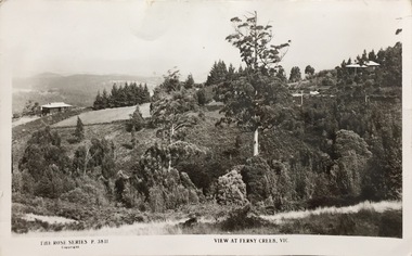
Postcard, Rose Stereograph Company, View at Ferny Creek, Vic, 1925-1939
The Kew Historical Society's postcard collection includes views of Kew, Melbourne and Greater Melbourne as well as those including overseas scenes sent or received from Europe or the Middle East. They date from the 1890s to the 2000s. These postcards may or may not include the name of the publisher or printer. A number of the cards were published as parts of popular series. A way of dating early postcards is to identify whether the reverse was divided by a central line which became the norm after 1902 in the United Kingdom. However, other postcards produced after this date do not always conform to this print layout.A Rose Series postcard of Ferny Creek in the Dandenongs to the north of Melbourne. The monochrome postcard is numbered P. 3811.Front: THE ROSE SERIES P. 3811 COPYRIGHT / VIEW AT FERNY CREEK, VIC. Reverse: POST CARD / THE ROSE SERIES DELUXE / A REAL PHOTOGRAPH PRODUCED IN AUSTRALIA / PUBLISHED BY THE ROSE STENOGRAPH CO., ARMADALE, VICTORIA / [Inscription] Many Happy Returns of the day, Mum.ferny creek - victoria, postcards -
 Kew Historical Society Inc
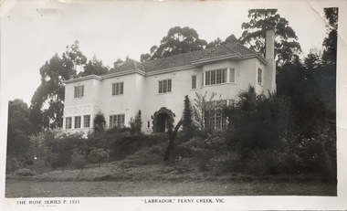
Postcard, Rose Stereograph Company, "Labrador," Ferny Creek, Vic, 1920-1939
The Kew Historical Society's postcard collection includes views of Kew, Melbourne and Greater Melbourne as well as those including overseas scenes sent or received from Europe or the Middle East. They date from the 1890s to the 2000s. These postcards may or may not include the name of the publisher or printer. A number of the cards were published as parts of popular series. A way of dating early postcards is to identify whether the reverse was divided by a central line which became the norm after 1902 in the United Kingdom. However, other postcards produced after this date do not always conform to this print layout.A Rose Series postcard of "Labrador" in Ferny Creek in the Dandenongs to the north of Melbourne. The postcard is numbered P. 1511.Front: THE ROSE SERIES P. 1511 COPYRIGHT / "LABRADOR' FERNY CREEK, VIC / THE ROSE SERIES DELUXE / A REAL PHOTOGRAPH PRODUCED IN AUSTRALIAferny creek - victoria, labrador - ferny creek, postcards, guest houses -- ferny creek (vic.), labrador -- ferny creek (vic.) -
 Kew Historical Society Inc
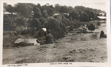
Postcard, Rose Stereograph Company, View at Ferny Creek, Vic, 1920-1938
The Kew Historical Society's postcard collection includes views of Kew, Melbourne and Greater Melbourne as well as those including overseas scenes sent or received from Europe or the Middle East. They date from the 1890s to the 2000s. These postcards may or may not include the name of the publisher or printer. A number of the cards were published as parts of popular series. A way of dating early postcards is to identify whether the reverse was divided by a central line which became the norm after 1902 in the United Kingdom. However, other postcards produced after this date do not always conform to this print layout.A Rose Series postcard of Ferny Creek in the Dandenongs to the north of Melbourne. The postcard is numbered P. 2880.Front: THE ROSE SERIES P. 2880 COPYRIGHT / VIEW AT FERNY CREEK, VIC / Reverse: POST CARD / THE "ROSE' SERIES DELUXE / A REAL PHOTOGRAPH PRODUCED IN AUSTRALIA / PUBLISHED BY THE ROSE STEREOGRAPH CO., ARMADALE, VICTORIArose stereograph company postcards, ferny creek - victoria, postcards -- ferny creek -
 Kew Historical Society Inc
Postcard, Oastler (Leading Stationer), Tramway Terminus, Kew, c.1913
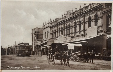
The Kew Historical Society's postcard collection includes views of Kew, Melbourne and Greater Melbourne as well as those including overseas scenes sent or received from Europe or the Middle East. They date from the 1890s to the 2000s. These postcards may or may not include the name of the publisher or printer. A number of the cards were published as parts of popular series. A way of dating early postcards is to identify whether the reverse was divided by a central line which became the norm after 1902 in the United Kingdom. However, other postcards produced after this date do not always conform to this print layout.A monochrome postcard of the tram terminus beside 'The Block' in Cotham Road, KewOastler, leading stationer, Kew / Printed in Saxonypostcards -- kew (vic.), trams -- kew (vic.), cotham road -- high street --- kew (vic.), the block -- cotham road -- kew (vic.) -
 Kew Historical Society Inc
Postcard, The Wertheim Piano Factory, Bendigo Street, Richmond, Melbourne, c.1906
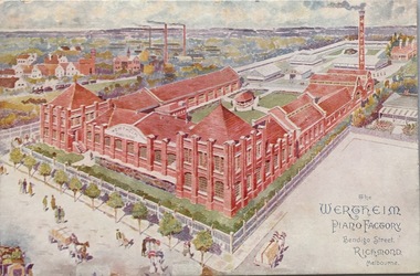
The Kew Historical Society's postcard collection includes views of Kew, Melbourne and Greater Melbourne as well as those including overseas scenes sent or received from Europe or the Middle East. They date from the 1890s to the 2000s. These postcards may or may not include the name of the publisher or printer. A number of the cards were published as parts of popular series. A way of dating early postcards is to identify whether the reverse was divided by a central line which became the norm after 1902 in the United Kingdom. However, other postcards produced after this date do not always conform to this print layout.Polychrome postcard of the Wertheim Piano factory in Richmond.KH-152. H.V. Barlow, Head Office, 173 William St., Melbournewertheim piano factory, bendigo street - richmond, postcards -- richmond (vic.) -
 Kew Historical Society Inc
Postcard, High Str., Kew, c.1906
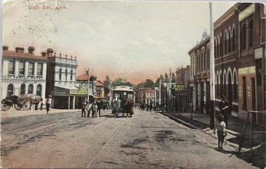
The Kew Historical Society's postcard collection includes views of Kew, Melbourne and Greater Melbourne as well as those including overseas scenes sent or received from Europe or the Middle East. They date from the 1890s to the 2000s. These postcards may or may not include the name of the publisher or printer. A number of the cards were published as parts of popular series. A way of dating early postcards is to identify whether the reverse was divided by a central line which became the norm after 1902 in the United Kingdom. However, other postcards produced after this date do not always conform to this print layout.Polychrome postcard of High Street, Kew looking west towards Kew Junction. The photograph was also printed in monochrome format by the publishers, with different names and additions.Reverse - (to) Miss __. J. Thompson, "Dry Lake", Kerang (from) Very sorry indeed to hear of your Mother's illness. Sincerely hope all quite well ere this. Still going about very tired waiting __ being away. Love to all M.B.L.high street -- kew (vic.), postcards -- kew (vic.), horse tram -- kew (vic.) -
 Kew Historical Society Inc
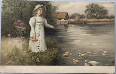
Postcard, Meissner & Buch, In Der Schonen Natur, 1902-1910
The Kew Historical Society's postcard collection includes views of Kew, Melbourne and Greater Melbourne as well as those including overseas scenes sent or received from Europe or the Middle East. They date from the 1890s to the 2000s. These postcards may or may not include the name of the publisher or printer. A number of the cards were published as parts of popular series. A way of dating early postcards is to identify whether the reverse was divided by a central line which became the norm after 1902 in the United Kingdom. However, other postcards produced after this date do not always conform to this print layout.Coloured postcard, produced in Germany, showing a girl feeding ducks beside a stream. The postcard was sent by Willie Feely to his cousin Alica (Alice Porter).Reverse: (To) Dear Alica. I will see you soon I will be home on Saturday week. I hope you are better. Give my love to your Mother and Father and Grandma I remain your loving Cousin, Wille Feely xxxxxxxxxx kissespostcards, german postcards, sentimental post cards -
 Kew Historical Society Inc
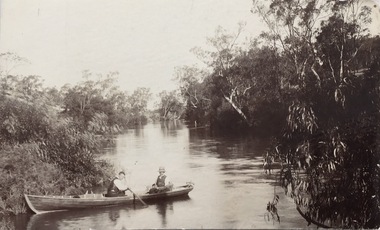
Postcard, Yarra Towards Fairfield, 1905-1914
The Kew Historical Society's postcard collection includes views of Kew, Melbourne and Greater Melbourne as well as those including overseas scenes sent or received from Europe or the Middle East. They date from the 1890s to the 2000s. These postcards may or may not include the name of the publisher or printer. A number of the cards were published as parts of popular series. A way of dating early postcards is to identify whether the reverse was divided by a central line which became the norm after 1902 in the United Kingdom. However, other postcards produced after this date do not always conform to this print layout.Monochrome postcard showing two men in a rowboat on the River Yarra at Kew in the area of Macaulay's Boat Shed.Handwritten later annotations: "Reg No KH-384. Yarra towards Fairfield. Macaulay's Boat House, Kew"postcards - kew (vic), river yarra - kew (vic), sport and recreation - kew (vic), recreation - kew (vic), boat sheds - kew (vic) -
 Kew Historical Society Inc
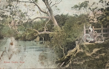
Postcard, River Yarra, Kew, 1905-1914
The Kew Historical Society's postcard collection includes views of Kew, Melbourne and Greater Melbourne as well as those including overseas scenes sent or received from Europe or the Middle East. They date from the 1890s to the 2000s. These postcards may or may not include the name of the publisher or printer. A number of the cards were published as parts of popular series. A way of dating early postcards is to identify whether the reverse was divided by a central line which became the norm after 1902 in the United Kingdom. However, other postcards produced after this date do not always conform to this print layout.One of a series of pictorial postcards showing a woman on a bicycle near to the River Yarra in Kew.Polychrome postcard of the River Yarra at Kew, showing a woman with a bike (right) looking away from the River.My dear friend I suppose you will think I am a "beauty", but I have no excuse to offer for not writing, only the longer I put it off the longer I want to. I hope the change did you a lot of good & that you feel quite well & strong. Everything here is something about the same. Our two new ministers are nice but I like Mr Dowsing better so far. The weather lately is glorious, just the thing for long walks. Jane Rowe & I go for a walk after church on Sunday nights. That is the most walking I do lately. No room for more. Love from your friend C.G.[sic]postcards -- kew (vic.), postcards -- yarra river -- kew (vic.), colour postcards -- kew (vic.) -
 Kew Historical Society Inc
Postcard, Little Residential, Your Little Piece of Kew, c.2013
The Kew Historical Society's postcard collection includes views of Kew, Melbourne and Greater Melbourne as well as those including overseas scenes sent or received from Europe or the Middle East. They date from the 1890s to the 2000s. These postcards may or may not include the name of the publisher or printer. A number of the cards were published as parts of popular series. A way of dating early postcards is to identify whether the reverse was divided by a central line which became the norm after 1902 in the United Kingdom. However, other postcards produced after this date do not always conform to this print layout.Commercial postcard produced by Little Residential showing the Kew War Memorial, the QPO Restaurant and the former Kew Court House.The reverse includes details about the company and its services (see image)postcards, qpo restaurant, kew post office, kew war memorial -
 Williamstown Botanic Gardens- Hobsons Bay City Council
Photos - Cannons, 1970
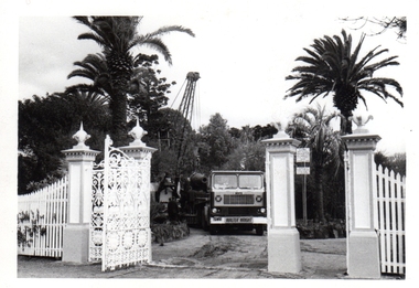
The Armstrong Cannons were originally placed at Fort Gellibrand, located at the southernmost tip of the Williamstown peninsula. The Fort was developed during the 1850s as part of a defensive system for the city and port of Melbourne. The importance of the Fort batteries declined from the 1890s, when they were effectively replaced by new facilities at Queenscliff and Point Nepean, but they were still used for gunnery practice. Local residents, through the Williamstown Town Council, complained to the Acting Minister for Defence that the concussion from the guns damaged windows, walls and foundations of buildings. The Armstrong Cannons were moved from Fort Gellibrand to the Gardens in 1906. A primary source of evidence of the cannons being in the Gardens. The cannons are remembered fondly as play equipment for the local children. Many tales have been told of climbing over them and pretending to be shot out of them A collection of seven black and white photographs documenting the removal of the cannons from the Gardens Photo 1 (a) Black and white landscape image. View is looking through the main gates looking at the front of the truck, which has the name Walter Wright across the front bumper, the crane and canon. The gates and fence are painted a light colour, probably white. Photo 2 (b) Black and white landscape image. Back of loader with cannon on it. Man standing on top of the cannon bending over either tying or untying ropes. Trunk of a palm tree is on the left side of the photo with a top of a palm tree in the background. Photo 3 (c) Black and portrait white image. A cannon being loaded by the crane on to trailer. Palm tree is in the background and fronds from a palm tree can be seen in the right top corner. Photo 4 (d) Black and white landscape image. Side on view of a cannon on the truck parked outside the grounds of the Gardens. The logo of the name of the trucking company is on the door of the truck above the words ‘WALTER H WRIGHT / TRANSPORT PTY LTD / S SCHULZ ST WEST MELB’. A second cannon can be seen in the background. A bus is in the background on the middle right side of the image. Photo 5 (e) Black and white landscape image. Truck with cannon on the back leaving the ground of the Gardens. Tree on the right side of the image and power pole is behind the truck. The logo of the name of the trucking company is on the door of the truck above the words ‘WALTER H WRIGHT / TRANSPORT PTY LTD / S SCHULZ ST WEST MELB’. ‘WALTER WRIGHT’ is on the front bumper Photo 6 (f) Black and white landscape image. Cannon tied down on the back of the truck as it is being driven across the street. Three houses in the background and two cars, one is a Volkswagen Photo 7 (g) Black and white landscape image. Cannon on the back of the truck which is parked over the street from the Gardens. Three houses are in the background. Two trees bare of leaves. The front of a car in in the foreground – it has a sun visor and the steering wheel is a light colour.armstrong cannons, williamstown botanic gardens, hobsons bay city council, 1970, walter h wright / transport pty ltd -
 Vision Australia
Audio - Sound recording, Vision Australia, Around Vision Australia: Episode 22
Covering issues and news about Vision Australia and the opportunities it provides for clients, volunteers and staff. Host: Stephen Jolley with guest interviews by Valerie Thomas. Stephen talks with Rachel Johnson about Tilly Aston establishing the first library in the 1890s, the production of 21st Century talking books and how to become a member of the library. Valerie Thomas interviews Dr Lynne Davies about the way Vision Australia reports assist the chairman implement the Client representative Council framework. Finally, Donor Relations Manager Sharon Standen provides an overview of her role in helping fund services.1 digital sound file in WAV formatradio shows, vision australia, valerie thomas, stephen jolley, rachel johnson, lynne davies, sharon standen -
 Buda Historic Home & Garden Castlemaine
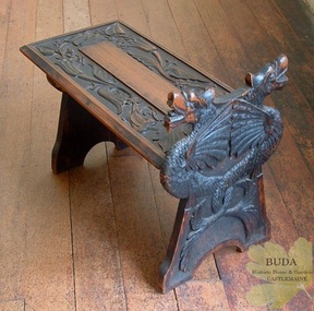
Domestic furniture, Timber hand-carved boot stool, c1900
The British Arts and Crafts Movement was a major influence on handcrafts made by the Leviny women at Buda. This Movement spread knowledge of craft techniques in the decorative arts and encouraged women to partake in fields that had traditionally been the domain of men, such as metalcraft and woodwork. The Leviny women studied art, design and craft techniques at the Castlemaine School of Mines from the 1890s to the early 1900s and this boot stool, hand-carved by Gertrude, is an example of the influence of the Arts and Crafts Movement on her decorative art. See: Zilles, Lauretta (2010), Buda and the Leviny Family, Castlemaine: Buda Historic Home & Garden Inc.This is a rare example of a unique hand-carved boot stool made in Australia by Gertrude Leviny in the British Arts and Crafts Movement style at the turn of the twentieth century.Timber boot stool, hand-carved by Gertrude Leviny. Made using the 'chip carving' technique, with dragon heads on upright at one end, and plant design in relief on the seat. Timber finish has a blackened effect.'K/40' (Old Registration Number)gertrude leviny, wood carving, arts and crafts movement, buda, castlemaine, dragon's heads, c1900, domestic furniture, castlemaine school of mines -
 Linton and District Historical Society Inc
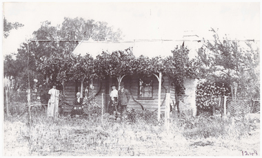
Photograph, Crosier Family Home at Happy Valley
This photograph is believed to have been taken in the 1890s at the Crosier property at Happy Valley (the Crosiers lived along the road leading to the Happy Valley School. Crosier descendants still live on this site). People in the photo are thought to be, L-R: Nell Crosier, Mary Crosier (née Hogan), Maggie Crombie (née Crosier), Jack Crombie. Mary Crosier was the second wife of Henry Crosier (1825-1901), a miner and farmer at Happy Valley. They had eight children. Their oldest daughter Maggie Crosier (1865-1932) married John Charles (Jack) Crombie in 1893. The Crombies farmed at Durham Lead.Black and white copy of original photograph showing a small weatherboard house with climbing plants along the verandah. Standing in front of the house are two women, with an older lady sitting between them, and a gentleman standing on the right, next to one of the women.crosier family home, miss crosier, mrs crosier, jack crombie, maggie crombie (nee crosier), happy valley -
 Brighton Historical Society
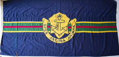
Flag, School flag, circa 1914 - 1956
This flag was used by Esperance Girls School, a private school based in Brighton from 1894-1956. Esperance was established in 1894 at 6 Normanby Street by Misses Emsie, Marion, Gussie and Daisy Beaver. The four sisters came from a formerly-prosperous land-owning family that had suffered badly as a result of the depression of the early 1890s. At a time when few occupations were open to gentlewomen, running a school provided the sisters with a respectable means of supporting themselves. Notable teachers at Esperance during the 1890s included elocution mistress Miss Jeannie Taylor, who would later become better known as the author Mrs Aeneas Gunn. In 1924 the school was sold to Miss Marian Taylor and Miss Christina McMillan, who had previously served as joint principals of Alexandra College in Hamilton between 1909 and 1913. Both women had strong family connections to Brighton: Christina was the granddaughter of early pioneer Archibald McMillan and Marian was a relative of long-serving town clerk J. H. Taylor. The new principals relocated the school to a large two-storey house on the corner of Park Street and Esperance Avenue, where it remained until its closure. They operated the school until 1950, when they sold it to a Miss Bury, who in turn sold it to the local Baptist Church in 1956. Following this final sale, the school continued for another four terms before closing.Navy blue flag, both sides featuring a large yellow-gold crest in centre, containing image of an anchor and surrounded by semicircular scroll with the motto "SPES ANCORA ANIMAE". Background features horizontal green stripe across centre, containing smaller red stripe and bordered on each side by yellow stripes.esperance girls school, flag, school flag -
 Warrnambool and District Historical Society Inc.
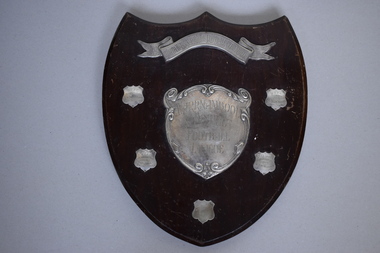
Shield, 1947
This trophy has been presented to the Warrnambool & District Football League by the South Warrnambool Football Club. This latter club still plays in the Hampden Football League and dates back to the 1880s and possibly beyond and has always been a traditional rival of the Warrnambool Football Club. West End Football Club dates back to the 1890s and joined with the Allansford Football Club in the 1960s to form the West End Allansford team. In 2001 the name ‘West End’ was dropped from the club’s name. Russells Creek Football Club was established in 1931 and still plays in the Warrnambool & District Football League which dates back to the early 1900sThis football trophy is of interest as it comes from the mid 20th century and concerns two local Warrnambool football clubs still existing today and one club that no longer exists.This is a wooden trophy in the shape of a shield. It has a silver scroll on the top and a silver heart shape in the middle. There is a cord on the back of the shield attached by metal hooks for hanging purposes. There are five small shields with etched writing on four of these. The shield is a little scratched. ‘South Warrnambool Football Club Shield’ ‘Warrnambool & District Football League’ ‘R.C.F.C. Premiers 1947 Tom Zanos (Captain) H. Drewitt (Coach)’ ‘W.E.F.C. Premiers 1948 P. Lake Capt. & Coach G.R.Thomas Pres.’ ‘W.E.F.C. Premiers 1949 W.L. ‘Jack’ McMurrick Capt. & Coach’ ‘West End F.C. Premiers 1950 W.L. McMurrick Capt. & Coach’ south warrnambool football club, warrnambool & district football league -
 Warrnambool and District Historical Society Inc.
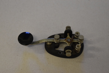
Morse code key, Mid 20th century
This is a Morse Code key. Morse Code is a method of transmitting text information using short and long signals (‘dots and dashes’). It is named after Samuel Morse, the inventor of the telegraph and was developed in the 1860s. It was used extensively in the 1890s for early radio communication before it was possible to transmit voice and continued to be used in the 20th century along with voice transmission , especially by amateur radio persons. It was also used in military and naval communication but not so much today. It is believed that this Morse Code key belonged to Ted Salamy, a jeweller and the first person in Warrnambool to hold an amateur radio licence (1924 Call Sign A3AJ, the 35th licence issued in Victoria).This Morse Code key is of interest as an object more used in the past, especially by amateur radio persons. It is believed to have been the property of Ted Salamy, the first person in Warrnambool to hold an amateur radio licence. This is a metal Morse Code key with an oval metal base. It has three screws inserted in the base and two more screws attached to the sides of the base. There is a key lever on top of the base and this is adjustable. The hinge on which the key lever sits is missing. The lever has a round black knob at one end. ‘Made in U.S.A. H15.682’ Wm.M. Nye Co Inc. Bellevue W.A.’ morse code key, ted salamy,, history of warrnambool -
Eltham District Historical Society Inc
Folder, Robert Lowman, 1882
Robert Lowman, Christmas Hills, 1882 Lowman built his Lowman's Hotel or Lowman's Folly on Osborne Road - Yarra Glen Road, Christmas Hills in the 1870s when the main road from Christmas Hills to Yarra Glen (then "Yarra Flats") used to follow the present Eltham -Yarra Glen Road to Osborne Road, then followed that to Mt Wise Road and down the escarpment. Years later a new road was opened leaving Lowmna's Hotel high and dry to gain renown as "Lowman's Folly". It closed in the early 1890s. See Christmas Hills Past and Present Brochure (Yarra Glen District Historical Society), 2004Folderrobert lowman, hotelier, christmas hills -
 Warrnambool and District Historical Society Inc.
Tools, Name Stamp, Late 19th century/early 20th century
This is the stamp used by Ernest Phillips to mark his tools and his products. It was used both on wood and metal surfaces. Ernest Brighton Phillips (1875-1924) was born in Warrnambool and was apprenticed as a cabinet maker at the Warrnambool Box Works. By the 1890s he had established a furniture shop at the corner of Liebig and Koroit Streets and by the beginning of the 20th century he had the largest furniture warehouse and factory in Victoria outside of Melbourne. His products were sold all over Australia. He and his family lived at ‘Heatherlie’ in Koroit Street and today this site is occupied by the flats complex for senior citizens called ‘Heatherlie’. This stamp is of interest because it belonged to Ernest Phillips, a prominent Warrnambool businessman (late 1800s to the early 1900s.) It is also of interest as an example of an early name stamp. This is a small piece of metal with a rounded flange top and a wider flattened end. The end is serrated and cut to hold the letters, ‘E. Phillips’. Some white paint has been splashed on the end section.‘E.Phillips’ (letters reversed for stamping purposes)ernest phillips, history of warrnambool -
 National Wool Museum
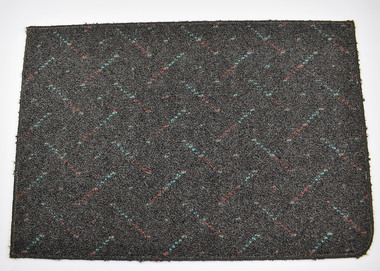
Carpet Samples, Godfrey Hirst and CO. Pty Ltd, c.1990
Carpet samples created by Godfrey Hirst, a carpet mill whose history spans back to 1865 when the Victorian Woollen and Cloth Manufacturing Company began operations in Geelong and was purchased in the 1890s by the man Godfrey Hirst. Godfrey Hirst’s entrepreneurial skills and knowledge of the industry led to the great success which saw the company expand in multiple forms over the next century and a half. Today, thousands of metres of carpet are produced by Godfrey Hirst every day, and their flooring can be found in millions of homes. These 6 carpet samples date from the early 1990s and each have a unique colour pattern and design.Each carpet sample is made with a pile fibre that is 100% wool. The primary backing of the carpet is a woven polypropylene with a secondary backing a woven jute. Carpet 8102.1's colour name is Slate. It has a dark grey background with a red and blue diagonal stripe. The pattern repeats in a 10cm x 11.5cm block. Carpet 8102.2’s colour name is Terracotta. It is a mostly block pink colour with no repeating pattern. It has occasional flicks of grey. Carpet 8102.3’s colour name is Arctic Night. It has white, light blue and grey colours repeating one after another in a diagonal line. Carpet 8102.4’s colour name is Ivory. It has a brown background with a cream colour diamond. The pattern repeats in a 15cm x 15cm block. Carpet 8102.5’s colour name is Glenwood. It has a thin darker green and lighter green horizontal stripe spanning its entire width. These stripes repeat the height of the carpet. Carpet 8105.6’s colour name is also Ivory. It has a brown background with a cream colour leaf pattern. The pattern repeats in a 92cm x 92cm block.Wording on rear: Numerous. See Media.godfrey hirst, carpet, textile manufacture -
 Kew Historical Society Inc
Plan, Melbourne & Metropolitan Board of Works : Borough of Kew : Detail Plan No.1576, 1904
The Melbourne and Metropolitan Board of Works (MMBW) plans were produced from the 1890s to the 1950s. They were crucial to the design and development of Melbourne's sewerage and drainage system. The plans, at a scale of 40 feet to 1 inch (1:480), provide a detailed historical record of Melbourne streetscapes and environmental features. Each plan covers one or two street blocks (roughly six streets), showing details of buildings, including garden layouts and ownership boundaries, and features such as laneways, drains, bridges, parks, municipal boundaries and other prominent landmarks as they existed at the time each plan was produced. (Source: State Library of Victoria)This plan forms part of a large group of MMBW plans and maps that was donated to the Society by the Mr Poulter, City Engineer of the City of Kew in 1989. Within this collection, thirty-five hand-coloured plans, backed with linen, are of statewide significance as they include annotations that provide details of construction materials used in buildings in the first decade of the 20th century as well as additional information about land ownership and usage. The copies in the Public Record Office Victoria and the State Library of Victoria are monochrome versions which do not denote building materials so that the maps in this collection are invaluable and unique tools for researchers and heritage consultants. A number of the plans are not held in the collection of the State Library of Victoria so they have the additional attribute of rarity.Original survey plan, issued by the MMBW to a contractor with responsibility for constructing sewers in the area identified on the plan within the Borough of Kew. The plan was at some stage hand-coloured, possibly by the contractor, but more likely by officers working in the Engineering Department of the Borough and later Town, then City of Kew. The hand-coloured sections of buildings on the plan were used to denote masonry or brick constructions (pink), weatherboard constructions (yellow), and public buildings (grey). Development in the 20th century has irreparably altered that part of Kew represented in this plan. In the block bounded by Cotham Road, Charles Street, Wellington Street and Gellibrand; just one house standing in 1903 remains. This block included two of the most historic houses in Kew: ‘Ordsall’ (later ‘Southesk’) and ‘Madford’ (previously ‘Elm Lodge’). Ordsall was the home of the second chairman of Kew, John Halfey. It contained some of the most significant interior murals in Kew, created for Halfey by artists working for Cullen & Co. It was demolished in 1960 to make way for the Kew Civic Centre. Elm Lodge had been built for William Siddeley in ca. 1864. Arthur Septimus King purchased it in 1874. The lower paddocks of Madford were sold in 1905 by his wife to the Borough of Kew and, after landscaping by George and Thomas Pockett, opened as the Alexandra Gardens in 1908. Elm Lodge/Madford was in 1922 to become St. Anthony’s Home for Little Children before its subsequent demolition in the 1980s.melbourne and metropolitan board of works, detail plans, maps - borough of kew, mmbw 1576, cartography -
 Kew Historical Society Inc
Plan, Borough of Kew Detail Plan No.1577, 1904
The Melbourne and Metropolitan Board of Works (MMBW) plans were produced from the 1890s to the 1950s. They were crucial to the design and development of Melbourne's sewerage and drainage system. The plans, at a scale of 40 feet to 1 inch (1:480), provide a detailed historical record of Melbourne streetscapes and environmental features. Each plan covers one or two street blocks (roughly six streets), showing details of buildings, including garden layouts and ownership boundaries, and features such as laneways, drains, bridges, parks, municipal boundaries and other prominent landmarks as they existed at the time each plan was produced. (Source: State Library of Victoria)This plan forms part of a large group of MMBW plans and maps that was donated to the Society by the Mr Poulter, City Engineer of the City of Kew in 1989. Within this collection, thirty-five hand-coloured plans, backed with linen, are of statewide significance as they include annotations that provide details of construction materials used in buildings in the first decade of the 20th century as well as additional information about land ownership and usage. The copies in the Public Record Office Victoria and the State Library of Victoria are monochrome versions which do not denote building materials so that the maps in this collection are invaluable and unique tools for researchers and heritage consultants. A number of the plans are not held in the collection of the State Library of Victoria so they have the additional attribute of rarity.Original survey plan, issued by the MMBW to a contractor with responsibility for constructing sewers in the area identified on the plan within the Borough of Kew. The plan was at some stage hand-coloured, possibly by the contractor, but more likely by officers working in the Engineering Department of the Borough and later Town, then City of Kew. The hand-coloured sections of buildings on the plan were used to denote masonry or brick constructions (pink), weatherboard constructions (yellow), and public buildings (grey). MMBW Plan No.1577 includes some of the most significant houses in Kew: Herbert Henty’s ‘Roxeth’ (now part of Trinity Grammar), ‘Butleigh Wooton’, ‘Bokara’ and ‘Harrow’. It also includes the streets that have since changed their names. That part of College Parade linked to Glenferrie Road is now named College Place, College Parade now extends further north, and Charles Street did not yet reach Barkers Road. Roxeth is one of a number of Henty houses in Kew. Herbert Henty made his home here and was elected a member of Kew Municipal Council in 1864 and mayor in 1868-69. Walter Henry Serle, of Harrow served in the First World War. He was awarded the Military Medal ‘’For conspicuous bravery and devotion to duty. On 29th September near BELLICOURT he showed the greatest bravery and determination when his platoon was attacked by enemy bombing parties. It was due largely to his personal efforts that all the attacks were repulsed. Until wounded, his utter disregard of personal safety and boldness in dealing with the attacks were the means of saving the situation and were an inspiring example to his men.’melbourne and metropolitan board of works, detail plans, maps - borough of kew, mmbw 1577, cartography -
 Kew Historical Society Inc
Plan, Melbourne & Metropolitan Board of Works : Borough of Kew : Detail Plan No.1578, 1904
The Melbourne and Metropolitan Board of Works (MMBW) plans were produced from the 1890s to the 1950s. They were crucial to the design and development of Melbourne's sewerage and drainage system. The plans, at a scale of 40 feet to 1 inch (1:480), provide a detailed historical record of Melbourne streetscapes and environmental features. Each plan covers one or two street blocks (roughly six streets), showing details of buildings, including garden layouts and ownership boundaries, and features such as laneways, drains, bridges, parks, municipal boundaries and other prominent landmarks as they existed at the time each plan was produced. (Source: State Library of Victoria). This plan forms part of a large group of MMBW plans and maps that was donated to the Society by the Mr Poulter, City Engineer of the City of Kew in 1989. Within this collection, thirty-five hand-coloured plans, backed with linen, are of statewide significance as they include annotations that provide details of construction materials used in buildings in the first decade of the 20th century as well as additional information about land ownership and usage. The copies in the Public Record Office Victoria and the State Library of Victoria are monochrome versions which do not denote building materials so that the maps in this collection are invaluable and unique tools for researchers and heritage consultants. A number of the plans are not held in the collection of the State Library of Victoria so they have the additional attribute of rarity.Original survey plan, issued by the MMBW to a contractor with responsibility for constructing sewers in the area identified on the plan within the Borough of Kew. The plan was at some stage hand-coloured, possibly by the contractor, but more likely by officers working in the Engineering Department of the Borough and later Town, then City of Kew. The hand-coloured sections of buildings on the plan were used to denote masonry or brick constructions (pink), weatherboard constructions (yellow), and public buildings (grey). MMBW Plan No.1578 is significant in that it defines the extent of two private schools: Xavier College and Kew High School (now part of Trinity Grammar) by 1904. In relation to the latter, the plan clarifies which buildings the High School operated from behind the mansion ‘Molina’. Established in 1902, Trinity Grammar was to later lease and subsequently buy Molina (now ‘Merritt House’) and ‘Elsinore’ (now ‘Roberts House’). Xavier College had been established in 1872. This 1904 plan delineates the West Wing and the Great Hall (built in 1890).melbourne and metropolitan board of works, detail plans, maps - borough of kew, mmbw 1578, cartography -
 Kew Historical Society Inc
Plan, Melbourne & Metropolitan Board of Works. Borough of Kew Detail Plan No.1579, 1904
The Melbourne and Metropolitan Board of Works (MMBW) plans were produced from the 1890s to the 1950s. They were crucial to the design and development of Melbourne's sewerage and drainage system. The plans, at a scale of 40 feet to 1 inch (1:480), provide a detailed historical record of Melbourne streetscapes and environmental features. Each plan covers one or two street blocks (roughly six streets), showing details of buildings, including garden layouts and ownership boundaries, and features such as laneways, drains, bridges, parks, municipal boundaries and other prominent landmarks as they existed at the time each plan was produced. (Source: State Library of Victoria). This plan forms part of a large group of MMBW plans and maps that was donated to the Society by the Mr Poulter, City Engineer of the City of Kew in 1989. Within this collection, thirty-five hand-coloured plans, backed with linen, are of statewide significance as they include annotations that provide details of construction materials used in buildings in the first decade of the 20th century as well as additional information about land ownership and usage. The copies in the Public Record Office Victoria and the State Library of Victoria are monochrome versions which do not denote building materials so that the maps in this collection are invaluable and unique tools for researchers and heritage consultants. A number of the plans are not held in the collection of the State Library of Victoria so they have the additional attribute of rarity.Original survey plan, issued by the MMBW to a contractor with responsibility for constructing sewers in the area identified on the plan within the Borough of Kew. The plan was at some stage hand-coloured, possibly by the contractor, but more likely by officers working in the Engineering Department of the Borough and later Town, then City of Kew. The hand-coloured sections of buildings on the plan were used to denote masonry or brick constructions (pink), weatherboard constructions (yellow), and public buildings (grey). While MMBW Plan No.1579 does not include many buildings, those that it does show are significant to Kew’s history. These include the ‘Kew [Railway] Station’ in Denmark Street and the ‘Recreation Hall’ and rear courts off Wellington Street. The plan shows the outline of the Recreation Hall, constructed in 1880, at the rear of which is listed a bowling green, two tennis courts, a ‘skittle alley’ and a pavilion. When the Hall was first built, the Kew Cricket Club occupied an adjacent ground, however in 1885 this was acquired by the State Government as the future location of the Kew Railway Station. The Plan also shows a single oval at Xavier College. This oval was completed in 1883. One of the current ovals conforms to this oval’s original shape and position in the school grounds.melbourne and metropolitan board of works, detail plans, maps - borough of kew, mmbw 1579, cartography -
 Kew Historical Society Inc
Plan, Melbourne and Metropolitan Board of Works, Borough of Kew : Detail Plan No.1580, 1904
The Melbourne and Metropolitan Board of Works (MMBW) plans were produced from the 1890s to the 1950s. They were crucial to the design and development of Melbourne's sewerage and drainage system. The plans, at a scale of 40 feet to 1 inch (1:480), provide a detailed historical record of Melbourne streetscapes and environmental features. Each plan covers one or two street blocks (roughly six streets), showing details of buildings, including garden layouts and ownership boundaries, and features such as laneways, drains, bridges, parks, municipal boundaries and other prominent landmarks as they existed at the time each plan was produced. (Source: State Library of Victoria)This plan forms part of a large group of MMBW plans and maps that was donated to the Society by the Mr Poulter, City Engineer of the City of Kew in 1989. Within this collection, thirty-five hand-coloured plans, backed with linen, are of statewide significance as they include annotations that provide details of construction materials used in buildings in the first decade of the 20th century as well as additional information about land ownership and usage. The copies in the Public Record Office Victoria and the State Library of Victoria are monochrome versions which do not denote building materials so that the maps in this collection are invaluable and unique tools for researchers and heritage consultants. A number of the plans are not held in the collection of the State Library of Victoria so they have the additional attribute of rarity.Original survey plan, issued by the MMBW to a contractor with responsibility for constructing sewers in the area identified on the plan within the Borough of Kew. The plan was at some stage hand-coloured, possibly by the contractor, but more likely by officers working in the Engineering Department of the Borough and later Town, then City of Kew. The hand-coloured sections of buildings on the plan were used to denote masonry or brick constructions (pink), weatherboard constructions (yellow), and public buildings (grey). The area represented in this detail plan has undergone significant change during the 20th century. The widening of High Street in the 1930s and 1950s involved the shops on the south side of High Street being demolished and later rebuilt to fit the widened street. Another significant loss was the mansion ‘Drayton’ fronting Wellington Street, owned at this stage by Susannah Fenton. Her family name would later to be given to Fenton Way, which was to be built over the grounds of the house following its demolition. The plan of the garden is particularly interesting, containing a batten dome fronting Wellington Street, an ornamental pond, a fountain and a brick and glass conservatory. The notes by the plumbing contractor on this plan are particularly detailed. Pink borders delineate the ownership of the varying parcels of land. Some of the better known owners listed include the real estate agent Cr. Henry de Castres Kellett (bt) and John Padbury, the funeral director. This particular plan provides a clear view of the configuration of the Kew Junction in 1903 and the commercial buildings that surrounded it.melbourne and metropolitan board of works, detail plans, maps - borough of kew, mmbw 1580, cartography -
 Kew Historical Society Inc
Plan, Melbourne & Metropolitan Board of Works : Borough of Kew : Detail Plan No.1581, 1904
The Melbourne and Metropolitan Board of Works (MMBW) plans were produced from the 1890s to the 1950s. They were crucial to the design and development of Melbourne's sewerage and drainage system. The plans, at a scale of 40 feet to 1 inch (1:480), provide a detailed historical record of Melbourne streetscapes and environmental features. Each plan covers one or two street blocks (roughly six streets), showing details of buildings, including garden layouts and ownership boundaries, and features such as laneways, drains, bridges, parks, municipal boundaries and other prominent landmarks as they existed at the time each plan was produced. (Source: State Library of Victoria)This plan forms part of a large group of MMBW plans and maps that was donated to the Society by the Mr Poulter, City Engineer of the City of Kew in 1989. Within this collection, thirty-five hand-coloured plans, backed with linen, are of statewide significance as they include annotations that provide details of construction materials used in buildings in the first decade of the 20th century as well as additional information about land ownership and usage. The copies in the Public Record Office Victoria and the State Library of Victoria are monochrome versions which do not denote building materials so that the maps in this collection are invaluable and unique tools for researchers and heritage consultants. A number of the plans are not held in the collection of the State Library of Victoria so they have the additional attribute of rarity.Original survey plan, issued by the MMBW to a contractor with responsibility for constructing sewers in the area identified on the plan within the Borough of Kew. The plan was at some stage hand-coloured, possibly by the contractor, but more likely by officers working in the Engineering Department of the Borough and later Town, then City of Kew. The hand-coloured sections of buildings on the plan were used to denote masonry or brick constructions (pink), weatherboard constructions (yellow), and public buildings (grey). The streets and built structures in this plan were surveyed in 1903 and released to contractors in 1904. In addition to the designation of building types by colour, the plan includes detailed descriptions of land use and ownership. While many buildings remain from this period, a number of the buildings represented have been demolished including the original Kew Town Hall, and the Congregational and Roman Catholic churches in Walpole Street. While the mansion ‘Illapa’ in Princess Street is still extant – now part of ‘Rylands’ – the neighbouring mansion ‘Elsmere’ was demolished some decades ago. Rivalling Illapa and Elsmere in size were two mansions in Walpole Street, one named on the plan as ‘Gnarlbine’. Over time, Kew Junction and the south side of High Street have been reconfigured and widened, so that the commercial buildings on the corner of Princess and High Street no longer exist. A surprising feature of this part of central Kew to the northwest of Kew Junction is the amount of vacant land. In a number of cases, this land is noted by the contractor as used for vegetable gardens.melbourne and metropolitan board of works, detail plans, maps - borough of kew, mmbw 1581, cartography -
 Kew Historical Society Inc
Plan, Melbourne & Metropolitan Board of Works : Borough of Kew : Detail Plan No.1582, 1904
The Melbourne and Metropolitan Board of Works (MMBW) plans were produced from the 1890s to the 1950s. They were crucial to the design and development of Melbourne's sewerage and drainage system. The plans, at a scale of 40 feet to 1 inch (1:480), provide a detailed historical record of Melbourne streetscapes and environmental features. Each plan covers one or two street blocks (roughly six streets), showing details of buildings, including garden layouts and ownership boundaries, and features such as laneways, drains, bridges, parks, municipal boundaries and other prominent landmarks as they existed at the time each plan was produced. (Source: State Library of Victoria)This plan forms part of a large group of MMBW plans and maps that was donated to the Society by the Mr Poulter, City Engineer of the City of Kew in 1989. Within this collection, thirty-five hand-coloured plans, backed with linen, are of statewide significance as they include annotations that provide details of construction materials used in buildings in the first decade of the 20th century as well as additional information about land ownership and usage. The copies in the Public Record Office Victoria and the State Library of Victoria are monochrome versions which do not denote building materials so that the maps in this collection are invaluable and unique tools for researchers and heritage consultants. A number of the plans are not held in the collection of the State Library of Victoria so they have the additional attribute of rarity.Original survey plan, issued by the MMBW to a contractor with responsibility for constructing sewers in the area identified on the plan within the Borough of Kew. The plan was at some stage hand-coloured, possibly by the contractor, but more likely by officers working in the Engineering Department of the Borough and later Town, then City of Kew. The hand-coloured sections of buildings on the plan were used to denote masonry or brick constructions (pink), weatherboard constructions (yellow), and public buildings (grey). Public buildings, coloured grey on the Plan 1582 include the police station and post office, churches and schools. The earliest church school, Common School No.356 was located at the rear of the Congregational Church in Peel Street. It was constructed in 1859. The first buildings of Kew Primary School No.1075 on the other side of Peel Street were constructed in 1871. The school in 1903 only occupied a small fraction of its current site. In 1903, where the rear playground is now located, were two weatherboard and one brick villa. Trinity Grammar School was founded in 1902 and opened in the Parish Hall at the rear of Holy Trinity Anglican Church. It was not to move to its current site until 1906. The outline of the building housing the Kew Fire Brigade in the centre of the north side of Walton Street is shown but not named on the plan. Further down Pakington Street stood the two-storey Italianate mansion ‘Overton’. The home of Stanford Chapman, it was to be featured in the Imperial Institute series of bromide photographs of Victoria, Vol. 1: Homes and scenery. It was later to become a boarding house before it was later demolished.melbourne and metropolitan board of works, detail plans, maps - borough of kew, mmbw 1582, cartography -
 Kew Historical Society Inc
Plan, Melbourne & Metropolitan Board of Works : Borough of Kew : Detail Plan No.1585, 1904
The Melbourne and Metropolitan Board of Works (MMBW) plans were produced from the 1890s to the 1950s. They were crucial to the design and development of Melbourne's sewerage and drainage system. The plans, at a scale of 40 feet to 1 inch (1:480), provide a detailed historical record of Melbourne streetscapes and environmental features. Each plan covers one or two street blocks (roughly six streets), showing details of buildings, including garden layouts and ownership boundaries, and features such as laneways, drains, bridges, parks, municipal boundaries and other prominent landmarks as they existed at the time each plan was produced. (Source: State Library of Victoria)This plan forms part of a large group of MMBW plans and maps that was donated to the Society by the Mr Poulter, City Engineer of the City of Kew in 1989. Within this collection, thirty-five hand-coloured plans, backed with linen, are of statewide significance as they include annotations that provide details of construction materials used in buildings in the first decade of the 20th century as well as additional information about land ownership and usage. The copies in the Public Record Office Victoria and the State Library of Victoria are monochrome versions which do not denote building materials so that the maps in this collection are invaluable and unique tools for researchers and heritage consultants. A number of the plans are not held in the collection of the State Library of Victoria so they have the additional attribute of rarity.Original survey plan, issued by the MMBW to a contractor with responsibility for constructing sewers in the area identified on the plan within the Borough of Kew. The plan was at some stage hand-coloured, possibly by the contractor, but more likely by officers working in the Engineering Department of the Borough and later Town, then City of Kew. The hand-coloured sections of buildings on the plan were used to denote masonry or brick constructions (pink), weatherboard constructions (yellow), and public buildings (grey). This plan, which covers parts of High Street, Pakington Street and Derby Street is dominated by two historic Kew mansions: ‘Konetta’ and ‘Ramornie’. Ramornie was constructed in 1890 for James Maitland Campbell, three times Mayor of Kew. Sold in 1940, it became a boarding house known as ‘The Towers’. Now a private residence again, it has only one of its three balconies remaining. The location of the missing two balconies can be seen on the plan. In 1903, the grounds of Ramornie included a large tennis court fronting Pakington Street. The rear of the property is shown as extending to Cobden Street. One of Kew’s oldest hotels, the Prospect Hill Hotel on the corner of High and Cobden Street was established in 1858. The outline of the hotel shown on the plan represents the second building on the site. During the 19th century it was often used for electoral meetings. The Prospect Hill Hotel was to be redeveloped again in 1928, by the local architect Robert McIntyre. Since the 1980s, the hotel has been a live music venue, the home of the Melbourne Jazz Club, a restaurant and a liquor outlet.melbourne and metropolitan board of works, detail plans, maps - borough of kew, mmbw 1585, cartography