Showing 38555 items
matching 2016-10-15
-
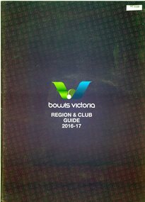 Heidelberg Golf Club
Book, Bowls Victoria, Bowls Victoria: Region & Club guide, 2016-2017, 2016
Bowls Victoria: Region & Club guide, 2016-2017 is a guide to bowling clubs throughout Victoria with contact details.53 p., colour illus., black and white textheidelberg golf club bowling club, lawn bowls, bowls victoria -
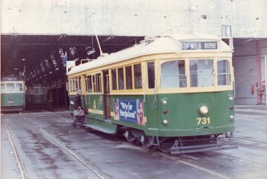 Melbourne Tram Museum
Photograph - Colour Print, Don English, 15/10/1983
Colour print of SW5 731 (Route 4) at South Melbourne Depot 15/10/1983. Keith notes it was the first of the W5 to SW5 conversions of the time. Photo Don English on the occasion of a TMSV Tour. Keith Kings is boarding the tram. W5 685 in the background.On rear in ink "TMSV, Tour is first of the mass W5 to SW5 conversions. 731 at South Melbourne Depot 15/10/83" and "Photo Don English"trams, tramways, tmsv, tours, w5 class, sw5 class, south melbourne depot, tram 731, tram 685 -
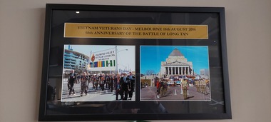 Diamond Valley Vietnam Veterans Sub-Branch
Photograph - Long Tan
Framed photo of VVAA (Vic) Sub Branches assembly at The Shrine, Melbourne, in August 2016 at the 50th Anniversary of the Battle of Long Tan.Historical record of some of the Vietnam Veteran Sub Branches in Victoria as at August 2016.Framed photo of VVAA (Vic) Sub Branches assembled at The Shrine, Melbourne, on 18th August 2016 at the commemoration of the 50th Anniversary of the Battle of Long Tan.Vietnam Veterans Day - 18th August 2016. 50th Anniversary of the Battle of Long Tan.vietnam, vietnam war, diamond valley vietnam veteran sub branch, long tan day -
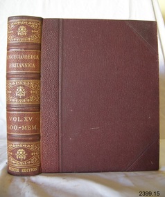 Flagstaff Hill Maritime Museum and Village
Book, The Encyclopaedia Britannica Vol 15
The Encyclopaedia Britannica Vol 15 Publisher Adam and Charles Black Date 1883Stamped Terang Mechanics Institute and Free Libraryflagstaff hill, warrnambool, shipwrecked-coast, flagstaff-hill, flagstaff-hill-maritime-museum, maritime-museum, shipwreck-coast, flagstaff-hill-maritime-village, book, the encyclopaedia britannica vol 15 -
 National Vietnam Veterans Museum (NVVM)
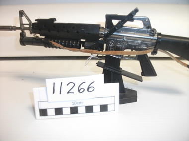
Weapon, Model AR-15, Dong San
Plastic and metal replica of a black cold AR-15 Dong San with standDS 23487dong san colt ar-15, model -
 Moorabbin Air Museum
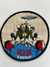
Badge (Item) - US Military Patch ? Possibly Vietnam Related With Markings N.15 KHMER
-
 Greensborough Historical Society
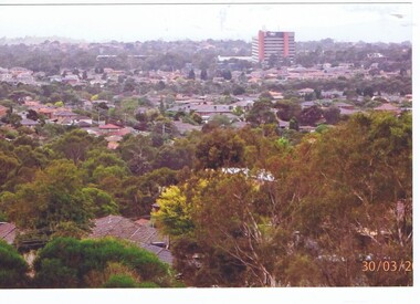
Photograph, Roy J. Mitchell, Mount Cooper 2016, 30/03/2016
Two photographs taken from Mount Cooper, the highest point in Melbourne, on 30/03/2016, by Roy J. Mitchell2 colour photographs and lettermount cooper, bundoora -
 Federation University Historical Collection
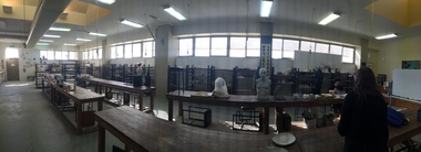
Photograph - Photograph - Colour, Ceramics Studio in the M.B. John Building, SMB Campus, 2016, 08/09/2016
This images show the working Ceramics Studio, but it is in the process of being packed up for the proposed move to another building by December 2016. A number of panoramic photographs of the Federation University Arts Academy Ceramics Studio located on SMB Campus in the M.B. John Building. The people in the photographs are Peter Pilven, Claire Blake and students. ceramics, m.b. john building, arts academy, peter pilven, claire blake -
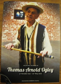 Mission to Seafarers Victoria
Card - Memorial card, In Loving Memory of Thomas Arnold Ogley 4th October 1931 - 19th May 2016. Seafarers Mission Chapel, May 2016
Tom worked as a volunteer at the Mission for three years as a Gardener, Mission Bus Driver. Produced for the funeral service held at the Mission 2016.The funeral service was held at the Mission ChapelFull colour print bifold card. Front cover features Tom in the Norla Dome, Mission to Seafarers. Memorial verse on page 3.thomas arnold ogley, mission volunteer, norla dome, services, chaplaincy, st peter chapel -
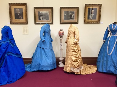 Kew Historical Society Inc
Photograph - Digital Photographs [Series], Robert Baker, Exhibition: Victorian Fashion, Kew Court House, 2016, 03/03/2016
From its beginnings in 1958, the Society has mounted exhibitions and/or displays, in early days in shop windows and in community spaces located in the Kew City Hall (later Kew Library), and since 2010 at the Kew Court House. Exhibitions typically coincided with the annual Kew Community Festival in March, but after 2013 evolved into three new exhibitions yearly at the Kew Court House. Smaller displays continue to be mounted in the Kew LibrarySeries of born digital images of an exhiition at the Kew Court House in 2016 of Victorian era costumes, largely drawn from the Coombs Collection of the Society. The mounting of the costumes was made possible by a City of Boroondara Strengthening Communities grant for 2015-16. Each of the costumes displayed here is separately catalogued on Victorian Collections.kew historical society - exhibitions, australian fashion - 19th century, coombs collection -
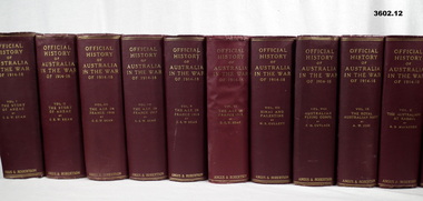 Bendigo Military Museum
Book - BOOKS WW1, Official History of Australia in the War 1914-18, 1), .3), .4), .5), .8), .9), .10), .11), .12) 1940; .2) 1938; .6) 1942; .7) 1939
12 x Volumes. Hard cardboard covers, red buckram, gold print on spines. Cut, plain, off white pages. Black / white photos, maps & illustrations. .1) Vol 1 The Story of ANZAC (Tenth Edition), 662 pages. .2) Vol 11 The Story of ANZAC (Sixth Edition), 975 pages. .3) Vol III The AIF in France 1916 (Tenth Edition), 1036 pages. .4) Vol IV The AIF in France 1917 (Tenth Edition), 1030 pages. .5) Vol V The AIF in France 1918 (Seventh Edition), 825 pages. .6) Vol VI The AIF in France 1918, 1096 pages. .7) Vol VII Sinai and Palestine (Eighth Edition), 844 pages. .8) Vol VIII Australian Flying Coirpr (Ninth Edition), 493 pages. .9) Vol IX The Royal Australian Navy (Eighth Edition), 649 pages. .10) Vol X The Australians At Rabaul (Eighth Edition), 412 pages. .11) Vol XI Australia During the War (Sixth Edition), 922 pages. .12) Vol XII Photographic Record of The War (Fourteenth Edition), 753 pages, glossy white paper.book, official history ww1, bean -
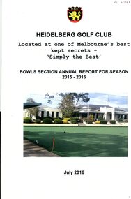 Heidelberg Golf Club
Booklet - Annual Report, Heidelberg Golf Club Bowling Club, Heidelberg Golf Bowling Club: Annual Report for season 2015-2016, July 2016
Heidelberg Golf Bowling Club: Annual Report for season 2015-2016. Note change of title: "Heidelberg Golf Club. Bowls section annual report for season 2015-2016". The integration of the Bowling Club into the management structure of the Golf Club took place during this year. The Bowling Club was formed in 1958 to enable members no longer able to walk the hills of the golf course to have a sporting involvement with the club.Annual reports found in this collection begin in 1959-60. Numbering of Annual Reports begins with the Eighth report in 1965-66.16 pages, stapled. Typed and copied report. 2 copiesannual reports, financial reports, heidelberg golf club bowling club -
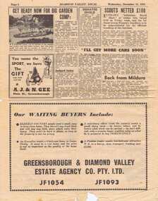 Greensborough Historical Society
Newspaper Clipping - Digital Image, Diamond Valley Local. 15 December 1954. Selection of 6 pages, 15/12/1954
A selection of pages from the Diamond Valley Local newspaper from 15 December 1954. News articles and advertisements from the Greensborough area.A snapshot of the local area in 1954.Scanned copies of local newspaper. 6 pages.diamond valley local -
 National Vietnam Veterans Museum (NVVM)
Memorabilia, Framed Polo Shirt, Veterens Day 2016
A Red Polo Shirt with Gold Trim Commemorates Fifty Years of Australian Vietnamese Relations on a Patch. Veterens Day 2016 is stitched on the inside of the shirt.veterens day 2016, framed polo -
 Moorabbin Air Museum
Equipment (item) - Parachute Pack Type B MK 15
-
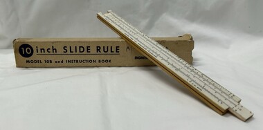 Greensborough Historical Society
Functional object - Ruler, Engineering Instruments, Inc, 10 inch slide rule model 10B and instruction booklet, 1947-1967
George Lee Lawrence (1901–1976) established a firm in Chicago to make slide rules for photography. In 1935 he moved to Wabash, Ind., renamed the company Lawrence Engineering Service, and began to manufacture general purpose slide rules. In 1938 he relocated once more to Peru, Ind., and in 1947 it was changed to Engineering Instruments, Inc., and the company remained in business until its building burned down in 1967. The model 10-B sold for 25 cents during this period. There is no record that Lawrence ever received a patent for any aspect of his design or manufacturing process.Used up to the 1960s prior to the invention of the electronic calculator.10 inch one-sided wooden slide rule painted white on the front face, which consists of two divided scales, one fixed and on movable, and a sliding window called a cursor. A, D, and K scales are on the base, and B, CI, and C scales the inside of the slide. The underside of the rule is marked with: tables for equivalents and conversions. Housed in cardboard box with instruction booklet.The top of the base is marked: MADE IN U.S.A. It is also marked ENGINEERING INSTRUMENTS, INC., PERU, INDIANA and PAT. PEND. Underside: This Famous Slide Rule... at a popular price. Solves Problems in Multiplication, Division, Proportion, Squares Roots, Cubes and Cube Roots, Reciprocals, etc., Instantly. Accurately Calibrated White Face on Well Seasoned Hardwood. Both ends of box: MODEL 10B-BK Price of 15 shillings handwritten on box.slide rule, mathematics -
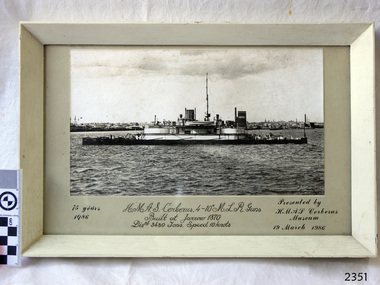 Flagstaff Hill Maritime Museum and Village
Photograph - Commemorative, Royal Australian Navy (RAN), H.M.A.S. Cerberus. 4-10" M.L.R. Guns, 1986
The ship HMAS Cerberus was Built at Jarrow, Newcastle upon Tyne, England, in 1870, specifically for the colony of Victoria (Australia) and originally named HMVS Cerberus. It had a displacement of 3480 tons and could travel at the speed of 10 knots. The ship carried 4x 10 inch M.L.R. guns. The ship was renamed HMAS Cerberus in 1911 when the navy became the Royal Australian Navy. The photograph was mounted by members of HMAS Cerberus at Crib Point, Western Port Bay, Victoria in 1986. It was presented to Flagstaff Hill Maritime Village by the HMAS Cerberus Museum in 1986 to commemorate the ship's 75 years of service for the Royal Australian Navy. The photograph is significant for its connection with the colony of Victoria before Federation. It is also significant for its connection with the Royal Australian Navy and its service and training of Australian defence forces. Photograph behind glass, in timber frame. Black and white photograph of vessel HMAS Cerberus anchored , with city in the background. Frame is painted white. Photograph was taken to commemorate 75 years of the ship's service in the Royal Australian Navy. It was framed and presented to Flagstaff Hill by the HMAS Cerberus Museum on 19 March 1986. Details are hand written below the photograph.Original script writing in centre "H.M.A.S. Cerberus. 4-10 M.L.R. Guns / Built at Jarrow 1870 / Displ 3480 tons. Speed 10 knots. More recent text "75 years / 1986" "Presented by / HMAS Cerberus / Museum/ 19 March 1986"flagstaff hill, warrnambool, shipwrecked-coast, flagstaff-hill, flagstaff-hill-maritime-museum, maritime-museum, shipwreck-coast, flagstaff-hill-maritime-village, photograph, hmas cerberus, 75 year commemoration, 1876, 1911, royal australian navy, navy training base, point crib, ran, cerberus, commemorative photograph, western port bay, hmvs cerberus -
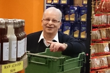
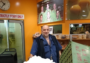 Greensborough Historical Society
Photograph - Digital image, Marilyn Smith, Bruno Sculli 2016, 19/07/2016
Bruno Sculli at work in Greensborough Plaza shop in 2016. The Sculli family came to Melbourne in the 1950s and in 1960 opened a fruit shop in Main Street Greensborough. Digital copy of colour photographsculli family, greensborough plaza -
 Greensborough Historical Society
Photograph - Digital image, Marilyn Smith, Vito Sculli 2016, 19/07/2016
Vito Sculli at work in Greensborough Plaza shop in 2016. The Sculli family came to Melbourne in the 1950s and in 1960 opened a fruit shop in Main Street Greensborough. Digital copy of colour photographsculli family, greensborough plaza -
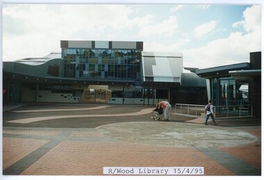 Ringwood and District Historical Society
photograph, Eastlink Ringwood Bypass Construction-Ringwood Library 15/4/95
Colour photographWritten on back of photo: "Ringwood Library 15/4/95" -
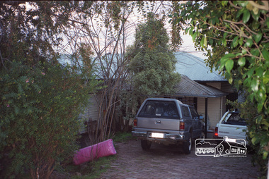 Eltham District Historical Society Inc
Photograph, Margaret Ball, 15 Luck Street, Eltham, June 1999, 1999
Owner 1950s-1960s: Mrs Ivy RewellThe Margaret Ball (Pre 1960s Houses) Collection was a personal project initiated to mark the year 2000 and arose as a result of the disappearance of many pre-1960s parts of Eltham due to development. Approximately 200 pre-1960s style houses that were left in Eltham between Main Road and east to Bible Street, between Cecil Street to the north and south to Dalton Street were photographed in late 1999. Not all of the houses could be photographed; some because the garden or trees blocked the view of the house, others because of rubbish or cars were in the way, some because people were working on the house or in the gardens at the time.Roll of 35mm colour negative film, 10 stripsFuji 200eltham, houses, streets, margaret ball (pre 1960s houses) collection, luck street -
Ballarat Tramway Museum
Magazine, RSL Victoria, Mufti - Vol. 56, No. 2 June 2016, Jun. 2016
Magazine - 76 pages including cover, "Mufti - Vol. 56, No. 2 June 2016 published by the Returned Services League Victorian Branch. On page 33 has an article about the launch of Cuthberts 939 and the Ballarat RSL and the BTM proposed for a new interpretative centre. Written by Lynne Redman, Welfare, Aged and Health Support Ballarat.trams, tramways, rsl, btm, museum, interpretative centre -
 Greensborough Historical Society
Photograph - Digital image, Marilyn Smith, Bruno and Vito Sculli 2016, 19/07/2016
Bruno and Vito Sculli at work in Greensborough Plaza shop in 2016. The Sculli family came to Melbourne in the 1950s and in 1960 opened a fruit shop in Main Street Greensborough. Digital copy of colour photographsculli family, greensborough plaza -
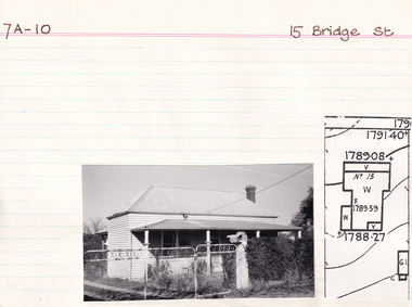 The Beechworth Burke Museum Research Collection
Card (Series) - Index Card, George Tibbits, 15 Bridge Street, Beechworth, 1976
George Tibbits, University of Melbourne. Faculty of Architecture, Building and Town & Regional PlanningIndex system that support the research for Beechworth : historical reconstruction / [by] George Tibbits ... [et al]Arranged by street names of BeechworthEach index card includes: street name and number of property, image of property, allotment and section number, property owners and dates of ownership, description of the property according to rate records, property floor plan with dimensions.beechworth, george tibbitsbeechworth, george tibbits -
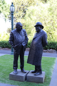 Ballarat Heritage Services
Photograph - Colour, Statue of Sir Rupert James Hamer, AC, KCMG, ED, 2016, 21/02/2016
Sir Albert Arthur Dunstan, KCMG was an Australian politician. A member of the Country Party (now National Party of Australia), Dunstan was the 33rd Premier of Victoria. His term as Premier was the second-longest in the state's history, behind Sir Henry Bolte. Dunstan, who was Premier from 2 April 1935 to 14 September 1943 and again from 18 September 1943 to 2 October 1945, was the first Premier of Victoria to hold that office as a position in its own right, and not just an additional duty taken up by the Treasurer, Attorney General, or Chief Secretary. Sir Henry BoltePrint Page Print this page 15-November-2018[Diane Watson] 15-November-2018[Diane Watson] 15-November-2018[Diane Watson] 21-November-201615-November-2018 [Diane Watson]21-November-201615-November-2018[Diane Watson]15-November-2018[Diane Watson]21-November-2016 Photographs supplied by Sandra Brown / Diane Watson A statue commemorates the former Premier of Victoria, Sir Henry Bolte for his services to Victoria and Ballarat. In the 1955 elections an almost unknown sheep farmer from the bush, Henry Bolte, became premier. His long, uninterrupted Liberal rule was a seminal period in Victoria`s history, not least for the unprecedented development of the hitherto languishing state and the political stability that his election in 1955 delivered. There was a chaotic political culture in Victoria before Bolte was elected. It was effectively a national joke with one minority government in 1943 lasting just five days and another in 1952 lasting only four.Statue of Henry Bolte and Sir Allbert Dunstantreasury gardens, statue, henry bolte, albert dunstan, premier -
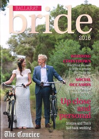 Ballarat Tramway Museum
Magazine, The Courier Ballarat, "Ballarat bride 2016", May. 2016
Magazine - 52 page, full colour A4 publication, centre stapled titled "Ballarat bride 2016". Features various stories about local weddings, wedding planning and advertisers including the BTM. Page 16 features a story of Ebony Burns & Benjamin Johnson with one of the BTM trams in the background and BTM advert on page 49 of services available for weddings.trams, tramways, btm, weddings, advertisements -
 Eltham District Historical Society Inc
Photograph, Liz Pidgeon, Heritage Excursion; Maroondah Aqueduct, 3 September 2016, 3 September 2016
Newsletter No., 229, August 2016 Heritage Excursion - Maroondah Aqueduct Walk - Saturday 3rd September The Maroondah Aqueduct was once a major link in Melbourne’s water supply system. It was built between 1886 and 1891 to transfer water from the Watts River near Healesville to the Preston Reservoir. It was 66 km in length, made up of 41 km of open channel, 10 km of tunnel through hills and 15 km of pipeline across stream valleys known as inverted siphons. The section of the aqueduct through the Eltham area has been abandoned since the 1980s but the open channel has largely been retained. A recreational path follows the aqueduct reserve. For our excursion on 3rd September we intend to walk along the section of the aqueduct adjacent to Allendale Road. This is a section not visited on previous excursions and includes the transition from open channel to the inverted siphon across the Diamond Creek valley. Apart from the aqueduct itself the main feature of the walk is the extensive views across Eltham North and Diamond Creek. Along the way we will talk about the history of the aqueduct and the area. This easy walk is about 3 km return and will take 2 to 2.5 hours. It will start at 2pm at the junction of Allendale Road with Godber Road and Zig Zag Road North, officially Diamond Creek, but on the northern boundary of Eltham. (Melway ref.12 B10). Born Digitalmaroondah aqueduct, eltham north, activities, eltham district historical society, heritage excursion, acqueduct trail, sign -
 Eltham District Historical Society Inc
Photograph, Liz Pidgeon, Heritage Excursion; Maroondah Aqueduct, 3 September 2016, 3 September 2016
Newsletter No., 229, August 2016 Heritage Excursion - Maroondah Aqueduct Walk - Saturday 3rd September The Maroondah Aqueduct was once a major link in Melbourne’s water supply system. It was built between 1886 and 1891 to transfer water from the Watts River near Healesville to the Preston Reservoir. It was 66 km in length, made up of 41 km of open channel, 10 km of tunnel through hills and 15 km of pipeline across stream valleys known as inverted siphons. The section of the aqueduct through the Eltham area has been abandoned since the 1980s but the open channel has largely been retained. A recreational path follows the aqueduct reserve. For our excursion on 3rd September we intend to walk along the section of the aqueduct adjacent to Allendale Road. This is a section not visited on previous excursions and includes the transition from open channel to the inverted siphon across the Diamond Creek valley. Apart from the aqueduct itself the main feature of the walk is the extensive views across Eltham North and Diamond Creek. Along the way we will talk about the history of the aqueduct and the area. This easy walk is about 3 km return and will take 2 to 2.5 hours. It will start at 2pm at the junction of Allendale Road with Godber Road and Zig Zag Road North, officially Diamond Creek, but on the northern boundary of Eltham. (Melway ref.12 B10). Born Digitalmaroondah aqueduct, eltham north, activities, eltham district historical society, heritage excursion, acqueduct trail, diamond creek -
 Eltham District Historical Society Inc
Photograph, Liz Pidgeon, Heritage Excursion; Maroondah Aqueduct, 3 September 2016, 3 September 2016
Newsletter No., 229, August 2016 Heritage Excursion - Maroondah Aqueduct Walk - Saturday 3rd September The Maroondah Aqueduct was once a major link in Melbourne’s water supply system. It was built between 1886 and 1891 to transfer water from the Watts River near Healesville to the Preston Reservoir. It was 66 km in length, made up of 41 km of open channel, 10 km of tunnel through hills and 15 km of pipeline across stream valleys known as inverted siphons. The section of the aqueduct through the Eltham area has been abandoned since the 1980s but the open channel has largely been retained. A recreational path follows the aqueduct reserve. For our excursion on 3rd September we intend to walk along the section of the aqueduct adjacent to Allendale Road. This is a section not visited on previous excursions and includes the transition from open channel to the inverted siphon across the Diamond Creek valley. Apart from the aqueduct itself the main feature of the walk is the extensive views across Eltham North and Diamond Creek. Along the way we will talk about the history of the aqueduct and the area. This easy walk is about 3 km return and will take 2 to 2.5 hours. It will start at 2pm at the junction of Allendale Road with Godber Road and Zig Zag Road North, officially Diamond Creek, but on the northern boundary of Eltham. (Melway ref.12 B10). Born Digitalmaroondah aqueduct, eltham north, activities, eltham district historical society, heritage excursion, acqueduct trail, sign -
 Eltham District Historical Society Inc
Photograph, Liz Pidgeon, Heritage Excursion; Maroondah Aqueduct, 3 September 2016, 3 September 2016
Newsletter No., 229, August 2016 Heritage Excursion - Maroondah Aqueduct Walk - Saturday 3rd September The Maroondah Aqueduct was once a major link in Melbourne’s water supply system. It was built between 1886 and 1891 to transfer water from the Watts River near Healesville to the Preston Reservoir. It was 66 km in length, made up of 41 km of open channel, 10 km of tunnel through hills and 15 km of pipeline across stream valleys known as inverted siphons. The section of the aqueduct through the Eltham area has been abandoned since the 1980s but the open channel has largely been retained. A recreational path follows the aqueduct reserve. For our excursion on 3rd September we intend to walk along the section of the aqueduct adjacent to Allendale Road. This is a section not visited on previous excursions and includes the transition from open channel to the inverted siphon across the Diamond Creek valley. Apart from the aqueduct itself the main feature of the walk is the extensive views across Eltham North and Diamond Creek. Along the way we will talk about the history of the aqueduct and the area. This easy walk is about 3 km return and will take 2 to 2.5 hours. It will start at 2pm at the junction of Allendale Road with Godber Road and Zig Zag Road North, officially Diamond Creek, but on the northern boundary of Eltham. (Melway ref.12 B10). Born Digitalmaroondah aqueduct, eltham north, activities, eltham district historical society, heritage excursion, acqueduct trail