Showing 1506 items matching "acres"
-
 Linton and District Historical Society Inc
Documents - purchase of land, Purchase of land by David McFadzean, 1872 - Allotment A1A, Township of Linton, Parish of Argyle
The land was purchased by David McFadzean under the 42nd section of the Amending Land Act, 1865. This allowed long-term tenants ("licensees") of government-held land to purchase ("alienate") the land. The allotment is in present-day Jackson Street, Linton.Twelve A4-size photocopies of documents relating to the purchase of an allotment of land - Allotment A1A, measuring 5 acres, 3 roods and 37 perches - within the boundaries of the Township of Linton. First page is headed "SECTION 31, "LAND ACT 1869". Documents include David McFadzean's application to purchase, notes made about the land and the application by officers of the Board of Land and Works, a plan of the allotment, and information about purchase price and fees.allotment a1a township of linton, david mcfadzean, victoria. amending land act 1865, conveyance, land sales, land purchases, documents and records, james beament -
 Bendigo Historical Society Inc.
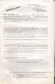
Document - MCCOLL, RANKIN AND STANISTREET COLLECTION: INDENTURE GOLD MINING LEASE 9201 BALLAARAT
6 page document plus map: indenture, gold mining lease dated 9th August 1960, between the Crown and North Deborah Mining Company, carrying on operations in the Parish of Moorarbool West . Key on map indicates depth to which land may be excised. On map: Mining District of Ballarat, County of Grant, Parish of Moorarbool West. Total area: 285 acres 1 rood, 20 perches. Vol 334, Fol 202.bendigo, mining, deborah gold mines -
 City of Moorabbin Historical Society (Operating the Box Cottage Museum)
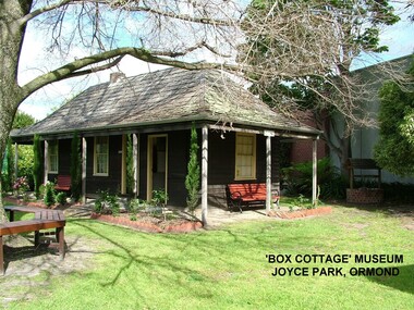
Photograph - ' Box Cottage' Reconstruction, c1841
The original small, pioneer cottage was built in the late 1840s to early1850s, by an unknown pioneer. It was located on part of a 30 Acre allotment that was originally part of Henry Dendy’s Special Survey granted in 1841. The doors and window sashes, (made of red deal joinery timber), as well as the brass locks and fittings, are from the original cottage, and were imported from England.The fire-place bricks are from the original cottage, and are sun-dried, (not kiln fired), and are hand-made. Convict marks can be seen on two bricks.There is a small display of external cladding shingles from the original pioneer cottage. These shingles were hand-split, and most likely made from locally collected timber The nails included in this display were used to fasten the shingles on the original cottage, and are also hand-made. The enamel nameplate, “Colonial”, on the wall of the cottage, was the name chosen for the original pioneer cottage when a later owner, Mr August Rietman and wife Frieda leased the property in around 1917. August purchased the property 1935 for 1200 Pounds approximately and resided there until 1953. In 1974 Mr Lewis, a timber specialist, found the dilapidated building on property he had recently purchased in Jasper Rd and suggested it be reconstructed and relocated. Moorabbin Council agreed and the Cottage was rebuilt just about 250 metres from its original site. The cost of the rebuild was met by 'Victoria's 150th Committee, plus a small grant from the City of Moorabbin, and Mr Laurie Lewis donated much of the timber for the reconstruction. Although 'Box Cottage' is a re-construction, it is an unique museum that, being located in the midst of a modern community in Ormond Victoria, can educate and demonstrate many aspects of the early settler’s way of life in Victoria. As such, it is an invaluable resource for students and all kinds of visitors. The original small, pioneer cottage was built in the late 1840s to1850s, by an unknown pioneer. It was located on part of a 30 Acre allotment that was originally part of Dendy’s Special Survey granted in 1841. The re-constructed pioneer cottage, named ‘Box Cottage’, is located only a matter of metres from the original pioneer cottage site, in Joyce Park, Jasper Road, Ormond, Victoria. The museum has copies of interesting Land Titles associated with the surrounding land, including the site of the original pioneer cottage, from Dendy’s time, and into the 1900s. ‘Box Cottage’ is named after the pioneers, William and Elizabeth Box, who resided in the original cottage from approximately 1865, until Elizabeth’s death in 1914.The re-constructed cottage plan has followed faithfully the original dimensions, and plan of the original pioneer cottage, and as many original items from that cottage’s long occupation have been incorporated. Convict marks on sun -dried, fire-place chimney bricks. Enamel nameplate 'Colonial' circa1915brighton, moorabbin, cottages, pioneers, ormond, colonial, mckinnon, dendy henry, box william, box elizabeth, convicts, rietman august, rietman frieda, rietman stefanie -
 Warrnambool and District Historical Society Inc.
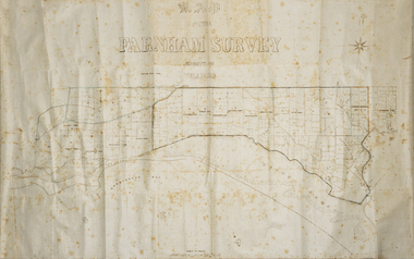
Map - Farnham Survey, 1850s
This is a map of the Farnham Special Survey. In 1843 William Rutledge purchased this Special Survey of 5,120 acres and named it Farnham. This Survey extended from Tower Hill to the Merri River at Dennington. The map appears to date from the 1850s This early map is of considerable significance as it shows details of the Farnham Special Survey. William Rutledge and his survey are important influences in the development of Warrnambool and district with the establishment of settlements at Killarney, Yangery and Tower Hill.A hand drawn map on waxed paper in brown, black and blue ink. It shows Armstrong's Bay, sea, Crown Land , the names of properties and some roads. It includes a compass direction diagram.farnham special survey -
 Linton and District Historical Society Inc
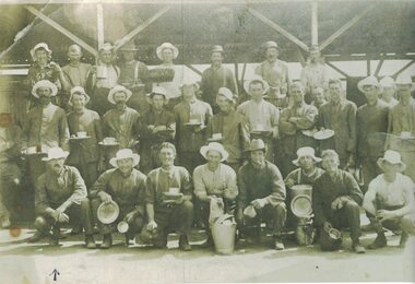
Photograph, Shearers at or near Linton
Photograph was donated by Claire Flowers, a granddaughter of George Brown.Black and white copy of original photograph which shows shearers grouped together for a photograph inside(?) an unidentified shearing shed. Nearly all of them are wearing sun-hats and most are holding cups or plates. The only person identified is George Brown, in front row with pipe in mouth.On printed slip of paper with photograph: "Photo of shearers at Linton, Front row, first left with pipe in mouht is my grandfather george Brown who was the pund keeper and lived on 16 acres on the Geelong Road behind Gillets. He married Annie Meredith Nicholls." Signed "Claire R. Flowers".shearers, shearing sheds, woolsheds, rural activity, george brown -
Clunes Museum
Document (Item), DEPARTMENT OF LANDS AND SURVEY, RENEWALS GARDEN LICENCE 5/
RECEIPT BOOK DEPARTMENT OF LANDS AND SURVEY. LICENCE TO ENTER UPON CROWN LANDS NOT EXCEEDING IN AREA ONE ACRE, AS SPECIFIED HEREUNDER, FOR PURPOSES OF GARDEN AND RESIDENCE. FEE PER ANNUM 5 / O (FIVE SHILLINGS) FIFTY CENTSlocal history, local government, council, licence, garden -
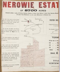 Bacchus Marsh & District Historical Society
Map, Nerowie Estate Land Sale 1910
The Nerowie Estate was a large rural property of 8,700 acres (3520 hectares) near the locality of Parwan only a few kilometers east of Bacchus Marsh. It had once formed a large part of the land owned by the pioneering Staughton family.A single page paper map showing the land offered for sale from the Nerowie Estate at Parwan near Bacchus Marsh in 1910. The map is pasted into a bound volume containing 76 maps or plans in total. High resolution digital image stored on BMDHS computer network. nerowie estate parwan, land sales parwan, land sales bacchus marsh, staughton family bacchus marsh -
 Whitehorse Historical Society Inc.
Document, Batman's "Melbourne" Deed, 6 June 1835
Batman's "Melbourne" Deed facsimile of the original held in the the Public Library of Victoria.non-fictionBatman's "Melbourne" Deed facsimile of the original held in the the Public Library of Victoria.aborigines, melbourne, batman john -
Clunes Museum
Administrative record - LICENSE BOOK, GARDEN LICENCE 5/
RECEIPT BOOK FOR DEPARTMENT OF LANDS AND SURVEY FOR THE YEARS 1889 - 1891 . LICENCE COSTING 5/- WAS ISSUED TO RESIDENTS TO PERMIT THEM TO ENTER UPON CROWN LANDS NOT EXCEEDING IN AREA. ONE ACRE AS SPECIFIED HEREUNDER, FOR PURPOSES OF GARDEN AND RESIDENCE.BLUE CARDBOARD COVERERED BOOK CONTAINING RENEWALS OF GARDEN LICENCE 5/- COVERING YEARS 1889 TO 1891. RECEIPT NOs 304811 TO 304830local history, book, licence, receipt, garden -
 Ringwood and District Historical Society
Photograph, Looking across remains of Frazer's orchard to state school, 1972
Updated Information from Bruce Frazer: This is Frazer's (not "Fraser") orchard, sold to A.V. Jennings Co. For housing development c1970. Address was "Alkoomi", Oban Rd. North Ringwood. State School 4120 was enclosed on its north & east sides by the orchard. Owned by Harold & Sylvia Frazer, 12 acres, growing mainly cherries plus plums & lemons. Photo was taken from neighbouring apple orchard (Williams) & shows street construction in the middle distance.Written on back of photograph, "Looking across remains of Fraser's orchard to state school, 1972". -
 Ringwood and District Historical Society
Photograph, Remains of Frazer's orchard, North Ringwood. State school on left - 1972
Updated Information from Bruce Frazer: This is Frazer's (not "Fraser") orchard, sold to A.V. Jennings Co. For housing development c1970. Address was "Alkoomi", Oban Rd. North Ringwood. State School 4120 was enclosed on its north & east sides by the orchard. Owned by Harold & Sylvia Frazer, 12 acres, growing mainly cherries plus plums & lemons. Photo was taken from neighbouring apple orchard (Williams) & shows street construction in the middle distance.Written on back of photograph, "Remains of [Fraser's] orchard. State school on left". -
 Bendigo Historical Society Inc.
Document - MCCOLL, RANKIN AND STANISTREET COLLECTION: JERSEY REEF GOLD MINING CO, 1935
Copy of as 4 page typewritten prospectus of the Datmouth (Jersey Reef) Gold Mining Company. The company is being formed for the purpose of acquiring from the vendor his interest in Gold Mining Lease No. 6449, having an area of 45 acres 2 roods 28 perches situated at Inglewood in the parishes of Glenalbyn and Inglewood, Mining District of Maryborough. The area embraces the Jersey Line of Reef and has a length along same of approximately 680 yards. Dated 1935.gold mining, miners' safety cage, gold mining, dartmouth, jersey reef, inglewood, glenalbyn -
 Bendigo Historical Society Inc.
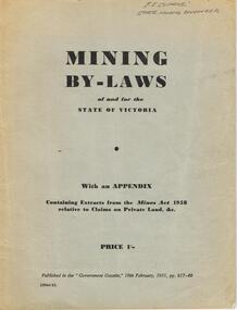
Book - AUSTIN COLLECTION: MINING BY-LAWS OF STATE OF VICTORIA 1958
BHS CollectionPale grey cover, booklet: mining By-Laws of and for the State of Victoria' Priced 1/- , containing extracts from the Mines Act 1958 relative to Claims on Private Land & etc. Written on top in pen 'P.E. Clarke, State Mining Engineer' 37 pages. Contains information regarding a wide range of mining practices e.g. 'dredging and sluicing claims' 'it shall not be lawful for any area exceeding five acres in extent to be held as a dredging claim or as a sluicing claim'.bendigo, mining, mining by-laws -
 Kiewa Valley Historical Society
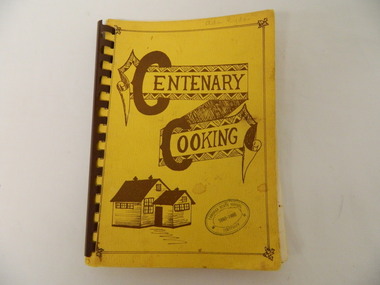
Book - Cooking x2, Centenary Cooking, 1980
The Tawonga School was a weatherboard building built on 8 acres of land catering for children from the surrounding grazing farms to ride their horses to school. It opened on 27th July 1880. The original school building and records were erased by fire in 1900. The Tawonga hall was used until 1910 when 3 acres of land was donated by Frank Cooper. It still operates today (2015) with its numbers having fluctuated over the years with the Kiewa Hydro Electric Scheme, tobacco farming and now tourism. The Tawonga community published a cook book to celebrate the school's centenary.This book may have also been used as a fund raiser.The Tawonga school celebrated its centenary with a cookbook with contributions from the community. This indicates that the school was very proud of reaching its centenary and the community co-operated with each other to develop this book.This book is a good source of the names of people who lived in Tawonga in 1980.Yellow book with brown writing and sketch of school held together with brown hard plastic binding. It has 90 pages of recipes most of which give the contributor's name.Tawonga State School Centenary 1880 - 1980 (stamped on front & back cover) In pencil on front cover: Ada Ryder An advertising for Kelvinator sticker has been stuck on the inside front cover with 18-3-92 written on it & on the inside back cover and 'Energy Rating' sticker.tawonga school. centenary of school. 1880-1980. cooking. food. kiewa valley -
 Eltham District Historical Society Inc
Photograph, Stevenson Homestead "Bankhead", Kangaroo Ground. Robert Stevenson and family
Stevenson, Robert, Kangaroo Ground, was born in the County of Evelyn, Victoria in 1845, He is the son of the late Joseph Stevenson and retains the property purchased by his father, with 47 acres adjoining, making in all 127 acres, where he carries on farming, and also a vineyard, the grapes from which have taken a number of prizes at agricultural societies’ shows at Heidelberg and other places. He was married in 1872, and has a family of two sons and five daughters. From: Victoria and it’s Metropolis: Past and Present by Alexander Sutherland ; R. L. J. Ellery ...[et.al. Melbourne : McCarron, Bird, 1888]. Page. 414 This photo forms part of a collection of photographs gathered by the Shire of Eltham for their centenary project book,"Pioneers and Painters: 100 years of the Shire of Eltham" by Alan Marshall (1971). The collection of over 500 images is held in partnership between Eltham District Historical Society and Yarra Plenty Regional Library (Eltham Library) and is now formally known as the 'The Shire of Eltham Pioneers Photograph Collection.' It is significant in being the first community sourced collection representing the places and people of the Shire's first one hundred years.Digital imagesepp, shire of eltham pioneers photograph collection, kangaroo ground, bankhead, robert stevenson, stevenson homestead -
 City of Moorabbin Historical Society (Operating the Box Cottage Museum)
Photographs, x 4 Black & White, Whitmuir Hall / Killearnan / Bentleigh Club 1930, c1930
Whitmuir Hall was built 1850 using bricks hand -made from the clay of nearby Elster Creek. Early history of the 156 acre estate bounded by McKinnon, Centre, Thomas and Wheatley Roads is obscure. The gardens were laid out prior to 1850. Robert Gray Ford purchased 20 acres with mansion in 1872 for £ 1750 and it was valued at £ 25,000 in 1888 but sold after the Bank Crash 1890's for £ 5,000 in 1892. There were many owners over the years including Thomas Bent and in 1870 it was called 'Killearnan'. It is now is known as 'the Bentleigh Club and many original features have been restored and preserved . Whitmuir Hall, was a stately mansion built 1850 typical of the grandiose plans of successful early settlers. Stained glass Windows, furniture, imported from France and Italy have been preserved by the Bentleigh Club.4 of 13 Black & White photographs of Whitmuir Hall now Benleigh Club, Yawla St Bentleigh c 1930whitmuir hall, bentleigh club, killearnan, mansions, gold rush victoria, smith j l; smith mary ann, stanley helen, smith vic, smith harry redvers, chaff cutter, horse drawn carts, toll gates brighton, motor cars 1900, steam engines, early settlers, bentleigh, parish of moorabbin, city of moorabbin, county of bourke, moorabbin roads board, shire of moorabbin, henry dendy's special survey 1841, were j.b.; bent thomas, o'shannassy john, king richard, charman s, highett william, ormond francis, maynard -
 Eltham District Historical Society Inc
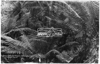
Photograph, Kinglake National Park; view from the Mountain Trail
Kinglake National Park was established in 1928 on 11,300 acres in the Shire of Eltham. Jehosophat Valley was named by the Hotelier Frank Thomson's father, who was so struck with the grandeur of the valley in all its pristine beauty that he 'ejaculated the word Jehosophat.'This photo forms part of a collection of photographs gathered by the Shire of Eltham for their centenary project book,"Pioneers and Painters: 100 years of the Shire of Eltham" by Alan Marshall (1971). The collection of over 500 images is held in partnership between Eltham District Historical Society and Yarra Plenty Regional Library (Eltham Library) and is now formally known as 'The Shire of Eltham Pioneers Photograph Collection.' It is significant in being the first community sourced collection representing the places and people of the Shire's first one hundred years.Digital imagesepp, shire of eltham pioneers photograph collection, kinglake, kinglake national park, view, bush, ferns, jehosophat -
 Mt Dandenong & District Historical Society Inc.
Photograph, Jeeves Coach on CRB Road at Foot of Farringdon Road Kalorama, 1920, 1920
Scene looking down Farringdon Road showing Jeeves horse drawn coach going along the CRB road (Mt Dandenong Tourist Road) in 1920. Detailed inscription on the back handwritten by John Lundy-Clarke in 1974.Jeeves Coach on CRB road at foot of Farringdon Road Kalorama (Mt Dandenong North) 1920. Road was formed most of the length from Montrose by contractors Bladin and Dick employing Robert Logan the younger, in 1919 and lay unmetalled till metalled by the contractors in 1922. Mountain ash trees in foreground were on Thomas Hand’s original 23 acre holding. Those beyond coach were on Isaac Jeeves original 160 acre holding Selection Crown Allotment 925(B). This was the area forming part of the inheritance lost by John William Richardson because of the expense of his wife’s illness. Hand enlarged his 23 acres to 305 in 1874. William and his family grew large crops of raspberries on his area, part of which is in the foreground. It had been cleared by his father’s employees before 1877. The section below the Main Road was cultivated by Fred hand, son of William and grandson of Thomas in the twenties before he moved to Redcliffes where he is today (1974). Comment by John Lundy-Clarke 10.5.1974 coach service, jeeves, crb road, farringdon road, kalorama, mt dandenong north, mt dandenong tourist road, john lundy-clarke, coach -
 Phillip Island and District Historical Society Inc.
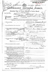
Document, Francis Joseph Dominick WW1 Enlistment and death documents
Francis was known as Joseph and his name is on the Cowes war memorial. The Dominick family had 40 acres on the Nobbies Road, next to the Smiths. He enlisted in South Melbourne on 27/10/1916 and was killed in action on 4 October 1917 in Belgium.Historical2 photocopied WW1 documents. One is his enlistment form and the other is a report of death in action.Australian Imperial Force Attestation Paper of Persons Enlisted for Service Abroad. Field Service Army Form B 20290Aworld war 1, joseph dominick, military, dominick family -
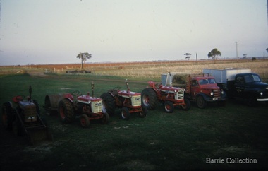 Melton City Libraries
Photograph, Farming 1960’s Ferris Road, 1965
Closed wire gate at the entrance to the 150 acres ploughed paddock. Tractor GBL 963 with front loader, HAB with Roller, JCJ 100, JCJ 101, Res Track, Red tray truck with straw bales, Black International with bine on tray.Photo taken in yard on south side of house facing Ferris Rd gate with stubble paddock on the right sideagriculture -
 City of Moorabbin Historical Society (Operating the Box Cottage Museum)
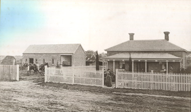
Photograph - 115 Jasper Road, Bentleigh, Allan / Grewer Estate, c. 1890's
115 Jasper Road, Bentleigh East was a market garden owned by James Allan. In 1880 the property was transferred to David Grewar (Gruar) who had married James' niece Mary Allan. In 1926 part of the land was subdivided and sold as residential blocks. The block with the house pictured remained in the family until 1969. The land now forms part of Our Lady of Sacred Heart College. The description of the land owned by David Kidd Grewer (also spelt Gruar) in 1885: Fourteen acres or thereabouts at the corner of Jasper Road and Patterson’s Road East Brighton being part of Crown Block of 5720 acres Parish of Moorabbin County of Bourke being land comprised in Certificate of Title Volume 1344 Folio 268692 on which is erected a 4 roomed brick house with 2 rooms of wood at the rear and stable and a 2 roomed weatherboard cottage valued as under: 14 acres of land less crops £629.0.0 4 roomed brick house £250.0.0 Other buildings £50.0.0 2 roomed weatherboard cottage £35.0.0 Early pioneer family of the City of Moorabbin.Black and White photo in picture framegrewar, market garden, moorabbin, bentleigh, jasper road, housing, pioneer, james allan, orchard -
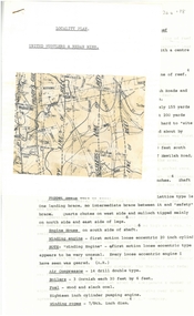
 Ringwood and District Historical Society
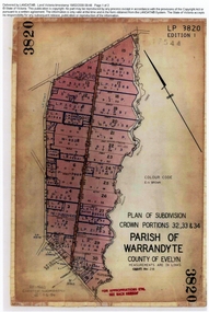
Document, Titles of land subdivision, Crown Portions 32, 33 & 34, Parish of Warrandyte, 1884 and 1907, Ringwood, Victoria
Evolution of the subdivision and the use of landBlack plastic bound pockets containing copies of 18 LANDATA subdivision maps and mortgage transfer pages dating from 1884 for 303 acres 2 roods and 1 perch bounded by Warrandyte Road, Wonga Road, Oban Road and Mullum Mullum Creek in Ringwood, Victoria. Certificates of Title include Vol 1606 Fol 045 Frederick Walter Purches 1884 and subsequent transfers to 1902, and Vol 3232 Fol 646357 Ann Jane Kennedy 1907 and transfers to 1921. -
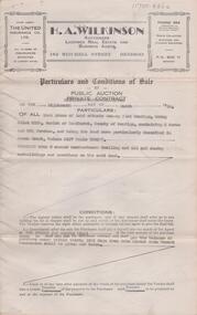
 Bendigo Historical Society Inc.
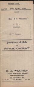
Document - H.A. & S.R. WILKINSON COLLECTION: CONDITION OF SALE
Conditions of sale by private sale dated 27th April 1944 between Mrs M.M. Williams (seller) and H.V. Ramage (buyer) for land situate Cohn Street near Holdsworth Road, Bendigo, being allotment 16 section K1, containing 2 acres, 1rood and 20 perches more or less in the City of Bendigo, described in Crown grant volume 6207 folio 1241225, together with 4-roomed weatherboard building, iron tank and all sundry. Price 33 pounds.organization, business, h.a. & s.r wilkinson real estate -
Bendigo Historical Society Inc.
Map - CAMPBELL COLLECTION: BENDIGO AND DISTRICT MAPS, 8-7-29
Map. Rifle Range, Parishes of Wellsford and Sandhurst. Scale 20 chains to 1 inch. Total area by Planimeter 5916 acres. Wallan and Bendigo Railway line. Rifle Range. Axedale township and station 8 miles. To Longlea Ryl station 2 1/2 miles. To Epsom 1 1/2 miles. To Bendigo 3 miles. Compiled in W.P.D. from Assessment and Parish Plans by H.A.D 8-7- 29 (number 367 in map cupboard 1)H.A.D.(H.A.Darby)map, bendigo, allotments -
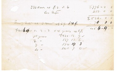
 Bendigo Historical Society Inc.
Document - H. A. & S. R. WILKINSON COLLECTION: CONTRACT OF SALE
Conditions of sale by public auction dated 18th March, 1950 between T. Pratt (vendor) and W. & M. G. Spedding (purchaser). Property: land situate Grassy Flat, Bendigo being allotment 218B, Parish of Sandhurst County of Bendigo, containing 2 acres and 26.5 perches, land described in Crown grant volume 3127 folio 625277, together with 5 room weatherboard dwelling and all sundry outbuildings. Price: 800 pounds. Attached 1 hand written note.organization, business, h.a. & s.r wilkinson real estate -
 Bendigo Historical Society Inc.
Document - CONNELLY, TATCHELL, DUNLOP COLLECTION: LEGAL PAPERS, 1890 - 1910
Document. Connelly, Tatchell & Dunlop - Legal Papers. 1 - Notes titled 'Crawfords land' 1902? 2 - 1890 - Torn notes - Commercial Finance Coy P? to Anderson. 3 - Torn Sheet - The Justices Act 1904, Third Schedule, Default Summons upon a complaint for a civil debt, in the court of Petty Sessions at Bendigo, in the Midland Bailiwick. 4 - Sundry General Costs concerning Custsons? R (name unreadable). 5 - Notes concerning 320 acres (notes not found).cottage, miners, connelly, tatchell & dunlop, commercial finance coy p?, anderson, the justices act 1904, custsons? r -
 Bendigo Historical Society Inc.
Document - LANDS OFFICE, CROWN LANDS SURVEYED AND SOLD, 1860/70
Document: buff hard cover journal, embossed on borders. On spine 'Lands and Survey' 'Index Book' and '03'. Contains list of parishes in front cover, indexed to page numbers which describes land surveyed and sold in parishes. Double page entries. 230 pages in book. LH page ' town lands, suburban lands, country lands, total lands surveyed, date of survey. RH page: date of sale, by auction, by selection, price per acre, total amount name of purchaser.Lands Officeland sales, lands office, land surveyed, land sold, bendigo, sandhurst -
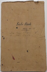 Bendigo Historical Society Inc.
Document - LANDS OFFICE: SANDHURST AND DISTRICT LAND SALES BY PUBLIC AUCTION 1859 - 60
Document: booklet, brown heavy paper cover bound secured with white cotton. Blue paper pages. On front cover ' Sale Book 1859, 60, 61. From August 16th. 1859 to Feb. 26 1861' Contains newspaper cuttings of crown land sales held in Sandhurst. Alongside cuttings are columns: price per acre, amount, purchasers. White sticker fixed to pocket: Book 7 Sandhurst Land Sales 16 August 1859 to March 1861Lands Officebendigo, land sales 1859 - 60, lands office, sandhurst, crown land, auctions -
 Bendigo Historical Society Inc.
Document - ALBERT RICHARDSON COLLECTION: UNITED HUSTLERS AND REDAN MINE
Four-page typed document plus location map. The United Hustlers and Redan mine was located in the North Bendigo, Long Gully area on the Hustlers line of reef. The lease was 153 acres and included Holdsworth, Holmes, Havilah Roads and Wood Street. The Redan shaft was 1,830ft and the South or K.K. Shaft was 1,960 ft. Poppet legs steel 71 ft high. Features of the plant are described including the engine house, winding engine, air compressor, boilers, fuel, winding ropes.bendigo, mining, united hustlers and redan mine -
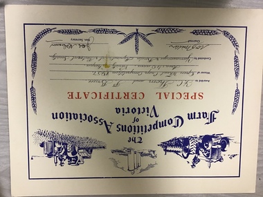 Yarrawonga and Mulwala Pioneer Museum
Prize certificate Yarrawonga A&P Association, Special certificate Crop Competition, 1957
Crop competitions have been held at local shows dating from late 1800’s to todayCream card Red and Blue print. Hand printed details of winner and description of Crop competition. Also has tractor and plough, silos tractor and header logos on top and wheat head logos on sides and bottom.The Farm Competitions Association of Victoria. Special certificate awarded to J C Thom ad P Bruce Open Wheat crop competition 1957 Area 40 acres. Variety Sherpa Conducted by Yarrawonga and Border Agricultural and Pastoral Society. Signed by Chairman Wm B Miller, Hon Secretary JWC McCann