Showing 15878 items
matching areas
-
 Bendigo Historical Society Inc.
Document - Forests Commission of Victoria Northern Area Fire Protection Policy, Statement, Future Bush Fire Policy, Plan for Fire Control, 1938-1939
Fanned by powerful winds, the Black Friday fires (13 January 1939) swept rapidly across large areas of Victoria, causing widespread destruction. Flames leaped large distances, and giant trees were blown out of the ground by fierce winds. Large pieces of burning bark (embers) were carried for kilometres, starting new fires in places that had not previously been affected by flames. Almost two million hectares burned across the state. Large areas of state forest, containing giant stands of Mountain Ash and other valuable timbers, were destroyed. As a result, approximately 575,000 hectares of reserved forest and 780,000 hectares of Crown land burned.Four Files Forests Commission of Victoria Northern Area Report on the 1938-39 Fire Season; and the Fire Protection Policy in Respect of Field activities Prior to the Incidence of the 1939 Fires. history, bendigo, forests commision of victoria, 1939 bush fires -
 Bendigo Historical Society Inc.
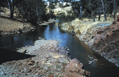
Slide - LAKE EPPALOCK(THE PLAY AREA), Jan 1965
Slide. Lake Eppalock(The Play Area). 23 Slides of the activities and areas at Lake Eppalock which included: Rivers, Pump Shed, Viewing Areas, Boating, Swimming, Picnicing, Fishing.slide, bendigo, lake eppalock(the play area) -
 Lakes Entrance Historical Society
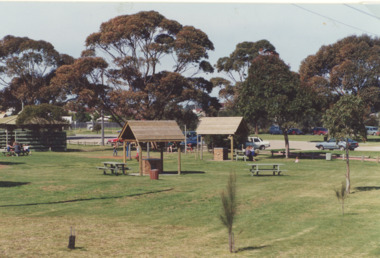
Photograph - Apex Park , Lakes Entrance Victoria, L E Tidy Town Committee, 1994
Apex Park barbeque area with people seated at picnic tables, cars parked at Visitors Information Centre glimpsed through trees, Lakes Entrance VictoriaAlso two colour photographs of barbeques and seating at Apex Park numbers 04240.1 and 04240.2 size 10 x 15 cmColour photograph of Apex Park barbeque area with people seated at picnic tables, cars parked at Visitors Information Centre glimpsed through trees, Lakes Entrance Victoriaparks, gippsland lakes, social history -
 Kiewa Valley Historical Society
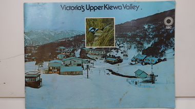
Booklet - SEC x2, 1. Victoria's Kiewa Valley 2. Victoria's Upper Kiewa Valley, No. 2 is dated October 1978
The State Electricity Commission of Victoria built the Kiewa Hydro Electric Scheme and was keen to promote tourism in the area. The booklet includes Facilities, Falls Creek Ski Resort, the Kiewa Works Area, the Three Floras of Bogong, the Geology of the Kiewa area, the Bird and Animal life of Bogong and the Kiewa Hydro Electric Scheme. The colored photos and the map on the back appeal to the reader/tourist.The SECV promoted tourism in the Kiewa Valley especially the area of the Kiewa Hydro Electric Scheme. This booklet is attractive and informative with a lot of detail. This proved to be the early stages of tourism in the area in what is now a very popular tourist destination and the main industry for the Upper Kiewa Valley.Blue cover with photo of Falls Creek at night. Title in black print at the centre top under which is an insert photo of a blue wren and SEC logo in white towards the top far right. Back cover is light green with a tourist map of the area. The text is complimented with brightly colored photos throughout.state electricity commission of victoria; kiewa hydro electric scheme; tourism; bogong; flora; fauna; geology; -
Port Melbourne Historical & Preservation Society
Poster, History of a Street Precinct
A cultural grant was given to Margaret BRIDE to implement this study, which she did with the help of her husband Graham and several residents of the study area including PMH&PS members Emily LOCK, David THOMPSON, Jack BOLT and Kerrie MATHEE.History of a Street Precinct, documenting 80 years plus of the history of the area bounded by Williamstown Road and Evans, Bridge and Farrell Streets, since 1880. One of two products of a 2005 project (which subsequently won the 2007 Victorian Local History Award for research). A brochure containing a map of the area and photos and information on key properties. An interactive CD (2148.02) containing information and photographs on 91 buildings and their occupants over time was also produced. built environment -
Port Melbourne Historical & Preservation Society
Mixed media, History of a Street Precinct
A cultural grant was given to Margaret BRIDE to implement this study, which she did with the help of her husband Graham and several residents of the study area including PMH&PS members Emily LOCK, David THOMPSON, Jack BOLT and Kerrie MATHEE.History of a Street Precinct, documenting 80 years plus of the history of the area bounded by Williamstown Road and Evans, Bridge and Farrell Streets, since 1880. One of two products of a 2005 project (which subsequently won the 2007 Victorian Local History Awards for research). An interactive CD containing information and photographs. This was packaged with a brochure (2148.01) containing a map of the area and photos and information on key properties and individuals on 91 buildings and their occupants over time.built environment -
 Lakes Entrance Historical Society
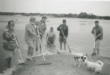
Photograph, Lakes Post Newspaper, 1996
cleaning up beach area east of the footbridge Lakes Entrance VictoriaGerard Kelly, Mike Lorimer, Mal Martin, Denis McGrath coordinator Trevor McCubbin and Greg Horin - 1996Black and white photograph showing Gerard Kelly, Mike Lorimer, Mal Martin, Denis McGrath coordinator Trevor McCubbin and Greg Horin cleaning up beach area east of the footbridge Lakes Entrance Victoriavolunteering, people, beaches -
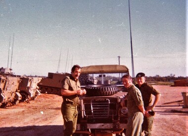 8th/13th Victorian Mounted Rifles Regimental Collection
Photograph
The western plains of southern NSW provided ideal training areas for a cavalry squadron engaged in reconnaissance training.Colour photograph of three officers of 8/13 Victorian Mounted Rifles standing near Land Rover during annual exercise in Balranald area c. 1979. From left: Lieutenant T. Goode, Captain J. Mclean and Captain T. fraser. -
 Rye RSL Sub Branch
Map Trench waterproofed cloth
A waterproofed cloth trench map of the Becelaere area, including Polygon Wood and other severely contested areas. -
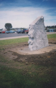 Lakes Entrance Historical Society
Photograph - WW1 Sholdiers Memorial Lakes Entrance, 1/11/1998 12:00:00 AM
rock from the entry at Shire Office Palmers Road after its relocation to the lawn area on Esplanade west of Post Office jetty Lakes Entrance Victoria. To be used as memorialo to WW1 Sholdiers from Lakes Entrance after removal of memorial avenue cypress treesColour photograph of rock from the entry at Shire Office Palmers Road after its relocation to the lawn area on Esplanade west of Post Office jetty Lakes Entrance Victoriamemorials, ww1, social history -
Whitehorse Historical Society Inc.
Document, The Fruitgrowers and Primary Producers Defence League of Australia, 1960 - 1961
List of members of the League - Doncaster, East Burwood, Wattle Glen, Panton Hill, Wantirna, Bacchus Marsh 1960-61.List of members of the League - Doncaster, East Burwood, Wattle Glen, Panton Hill, Wantirna, Bacchus Marsh 1960-61. Also envelope addressed to 'Mr W.G. & Mrs E.L. Payne, Bacchus Marsh with note 'List of members, Doncaster area'List of members of the League - Doncaster, East Burwood, Wattle Glen, Panton Hill, Wantirna, Bacchus Marsh 1960-61. clubs and associations, fruitgrowers and primary producers defence league of australia, payne, w.g., payne, e.l. -
Bendigo Historical Society Inc.
Document - VICTORIA HILL - THE RICH VICTORIA HILL AND IT'S HISTORICAL ASSOCIATIONS
Multiple handwritten and carbon copies refering to Victoria Hill. Mentioned in the notes are places of interest between Ironbark and Victoria Hill areas, history of the area and sign posts for the Victoria Hill area.document, gold, victoria hill, victoria hill, the rich victoria hill and it's historical associations, j n macartney, quartz miners' arms hotel, ironbark methodist church, greek orthodox church, conrad heinz, john brown industries knitwear factory, little 180 mine, george lansell, british & american hotel, victoria reef gold mining coy, manchester arms hotel, housing commission homes, the ironbark (victoria reef gold), hercules & energetic, midway, wittscheibe, gt central victoria, wm rae, mr and mrs conroy, mrs lavery, central nell gwynne, moorhead's shop, gill family, gold mines hotel, david chaplin sterry, new chum and victoria mine, p m g repeater station, old chum mine, pioneer, rotary club of bendigo south, north old chum mine, ballerstedt's first open cut, lansell's big 180 mine -
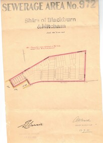 Whitehorse Historical Society Inc.
Document, Sewerage area, 13/07/1933 12:00:00 AM
Plan of sewerage area no. 972, Shire of Blackburn and Mitcham, scale 400' to an inch. 13 July 1933. Note that the area including Stuart Street on the map is now the Thiele Court area.sewerage and sanitation, shire of blackburn and mitcham, whitehorse road, blackburn, railway road, vine street, lithgow avenue, downing street, frankston street, stuart street, thiele court -
Whitehorse Historical Society Inc.
Document, Forest Hill Progress Association
A note stating that Nunawading Council donated 1,000 pounds worth of material in 1950.A note stating that Nunawading Council donated 1,000 pounds worth of material in 1950 to the Association for the erection of a public hall by members on the Forest Hill Reserve. The Association has been especially active in promoting the development of the Reserve as a recreation area.A note stating that Nunawading Council donated 1,000 pounds worth of material in 1950.clubs and associations, forest hill progress association -
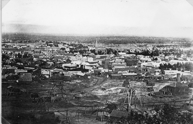 Stawell Historical Society Inc
Photograph, Panorama of Stawell from Big Hill with Whims & Poppet Heads Victorian Views Collection C Herbert c.1880s
Views from Big Hill Sloane Street Fisher Street areas looking towards West. Mining in foreground of photo. Upper Main Street and Patrick Street Streetscapes visible. Mathers and Franklin. Agnew Draper. J R Franklin? Draper. Coffee Palace formerly Castlemaine Hotel , Town Hall visiblePanorama of Stawell from Big Hill showing Sloane's St. / Fisher St. areas. The photo has Whims & Poppet Heads in the foreground. There are around 6 copes of the photograph. Victorian Views. C. Herbert. Photo. Copyright Registered. Stawellstawell, panorama, mining, streetscape -
 Bendigo Military Museum
Photograph - PHOTOGRAPHS, RABAUL
Set of B & W photos from WW2 taken around Rabaul area by Pte E. King.Series of B & W photos of Rabaul area. 1. Soldiers on parade. 2. - 4. Local children and adults. 5. - 6. Native militia on parade. 7. - 10. Australian soldiers swimming and sunbaking. 11. - 15. Snow views of Matupi Volcano and surroundings. photos, matupi, rabaul, volcano -
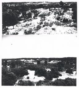 Bendigo Historical Society Inc.
Photograph - LONG GULLY HISTORY GROUP COLLECTION: PHOTO OF MINING AREA
Copy of two black and white photos of a mining area. the top photo shows a hilly area with vegetation and a track and the lower photo shows a bush area with a fence? behind some shrubs in the foreground.bendigo, history, long gully history group, the long gully history group - photo of mining area -
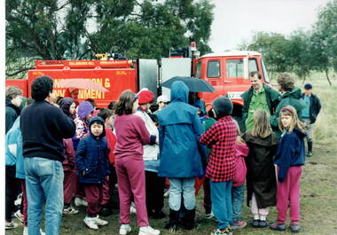 Sunbury Family History and Heritage Society Inc.
Photograph, Gellibrand Hill
The students from Bulla Primary School were taken on an excursion to Gellibrand Hill, a native parkland near Bulla. They did tree-planting and were taken for a ride around the park in the conservation and environment truck. After the ride a park ranger spoke to the group about the park and its importance in the local area.The excursion was included as part of the students science and environmental studies.A non-digital photograph of a group of children gathered around a red truck controlled by the Conservation and Environment personnel while a man explains to the children the importance of the vehicle. They are in a semi-bushland area. gellibrand hill, tree planting, bulla primary school, school excursions -
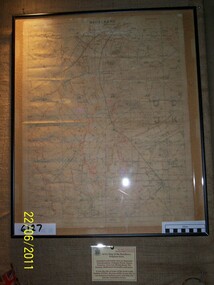
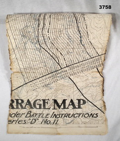 Bendigo Military Museum
Map - TRENCH MAP WW1, Possibly 1918
Villeret is centred within the areas of Rosiel, Bony, Bellicourt and Bellenglise. The map is possibly when the advance was into the Hindenburg Line in late 1918. Item re William Alexander No 502 AIF. Refer Cat No 3746.3 for his service details.Map, small section of a “Barrage map” showing objective lines with distances, enemy trenches are in blue. Top half and bottom half of the map are missing. Area covered appears to be “Villeret” scale 1:20,000map, trench, barrage -
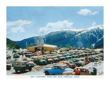 Falls Creek Historical Society
Postcard - Day Visitors' Shelter and Parking Area
These photographs were taken in and around Falls Creek by Samuel Keith Pearce and printed for him as a foldout postcard by NuColor Vue. The postcards state they were printed for S. K. Pearce Pty. Ltd of Tawonga and Mount Beauty. Samuel Keith Pearce was born on 24 June 1917 in Armadale, Victoria. By the late 1940s he owned the Mt Beauty Supermarket, Newsagency, Drapery and Hardware store at Mount Beauty and also a store at Tawonga in partnership with his brother Gordon Cathew Pearce. For some time, they operated as Pearce Brothers. In the early 1960s Keith also opened a mini mart In Falls Creek. As well as being a keen photographer and an astute businessman, Keith Pearce was a well-known identity in the Kiewa Valley, making many contributions to the development of the area over a long period. This included serving as a member of the Bright Shire Council for many years. He worked hard to promote the interests of the Upper Kiewa Valley. As a sign of recognition and appreciation for his contribution to the community, the park opposite the grocery store in Mount Beauty was named the SK Pearce Gardens in his honour. Samuel Keith Pearce died on 7 July 1994 in Mount Beauty, VictoriaThis collection of postcards and image is significant because they were commissioned by a highly successful business in Falls Creek, Victoria.A postcard featuring a coloured image of the very busy Day Visitors' Shelter and Parking area.astra falls creek, falls creek accommodation, falls creek businesses -
 Ringwood and District Historical Society
Map, Department of Mines, Plan of area applied for under the mining leases regulations in the township of Ringwood between Maroondah Highway and Mt. Dandenong Road. Mining District of Castlemaine, County of Mornington, Parish of Ringwood T Area 58(A) 2 (R)15(P) Acres, Roods, Perches. 1934, 20-Feb-34
Map of the township of Ringwood with subdivisions between Maroondah Highway and Mt. Dandenong Road. the area applied for on lease No.8210 by E.G.Browne.Mining District of Castlemaine, County of Mornington, Parish of Ringwood T Area 58(A) 2 (R)15(P) Acres, Roods, Perches.Buff coloured sheet foolscap with black printing showing map of the township of Ringwood between Maroondah Highway and Mt. Dandenong Road. Mining District of Castlemaine, County of Mornington, Parish of Ringwood T Area 58(A) 2 (R)15(P) Acres, Roods, Perches +Additional Keywords: Browne E.G. -
Whitehorse Historical Society Inc.
Document, My memories of the area around Simpson Park, 1/10/2003 12:00:00 AM
Memories with promptings from Jack Leach who lived in Rupert Street and later in Creek Road.Memories with promptings from Jack Leach who lived in Rupert Street and later in Creek Road. Describes that part of Mitcham south of the railway line between Creek Road and Cochrane street. A sketch map of the area as it was in the 1930's is also supplied.Memories with promptings from Jack Leach who lived in Rupert Street and later in Creek Road.brunswick road, mitcham, creek road, mitcham, cochrane street, mitcham, rupert street, mitcham, bloom family, leach, jack, leach family, simpson family, ferris, ray, simpson park -
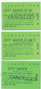 Melbourne Tram Museum
Ephemera - Ticket - City Saver - set of 3, The Met, c1990
Used by The Metropolitan Transport Authority (The Met) to provide a multi-journey trip ticket within a nominated City (CBD) area. Could be used for 10 trips. A check ticket was issued by a conductor for each trip made. Has details of the availability on the rear. Notes that the ticket is available for trams, buses and light rail. Two different versions - priced at $7.20 and one unpriced. The first has The Met logo on the rear (see item 6313 for $5.60 version). The unpriced version has the PTC logo on the rear, indicating a later issue. c1990.Demonstrates a multi-use ticket used by The Met in the City area of Melbourne.Set of 3 City Savers, printed on green card with a map of the available CBD travel area on the rear. Nos - 37482, 37494, and 277526. All have been stamped "Cancelled"public transport, tickets, the met, tramways, city saver, ptc -
University of Melbourne, Burnley Campus Archives
Document, Amenity Horticulture Orientation Walk, 1980-1990
Description of areas of Burnley with a planamenities, horticulture, burnley -
Whitehorse Historical Society Inc.
Pamphlet, Vermont directory, 2007
Directory of businesses in the Vermont area.Directory of businesses in the Vermont area.Directory of businesses in the Vermont area.vermont, directory -
Stawell Historical Society Inc
Map, Plan of the Agricultural Area of Callawadda, 1865
Plan of the Agricultural Area of Callawaddastawell -
Stawell Historical Society Inc
Map, Agricultural Area of Lake Wilson, 1865
Agricultural Area of Lake Wilsonstawell -
University of Melbourne, Burnley Campus Archives
Photograph - Black and white print, 49/15, 1947
Staff member in Agrostology area.staff, agrostology, e. m. gibson collection -
University of Melbourne, Burnley Campus Archives
Photograph - Black and white print, 76/27, 1947
Weather Station in Agrostology area.weather station, agrostology, e. m. gibson collection -
University of Melbourne, Burnley Campus Archives
Photograph - Black and white print, 831/2
Students hoeing in Agrostology area.students, hoeing, agrostology, e. m. gibson collection