Showing 562 items matching "army svy regt"
-
 Bendigo Military Museum
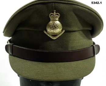
Uniform - SERVICE DRESS, ARMY - Royal Australian Army Survey Corps Uniform, Commonwealth Govt Clothing Factory, 1970-1988
... Army Svy Regt... Survey Corps RASvy Army Survey Regiment Army Svy Regt ASR Jacket ...This is the peaked cap and uniform of 36898 Warrant Officer Thomas William Pattison, Royal Australian Survey Corps, Army Survey Regiment who served from 21 Mar 1960 until 16 Jan 1993 and died whilst in service.1. Cap - Polyester, Khaki, small peak, leather band, metal Insignia. 2. Jacket - polyester, khaki, yellow metal buttons, Insignia badges, purple lanyard, embroidered Insignia lower sleeves. 3, Shirt - polyester, short sleeves, embroidered insignia on sleeves. 4. Pants - Polyester, Khaki.Jacket - embroidered Insignia on lower sleeves - Crown.uniform, army, royal australian survey corps, rasvy, army survey regiment, army svy regt, asr -
 Bendigo Military Museum
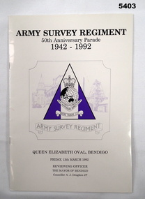
Booklet - Army Survey Regiment 50th Anniversary Parade Souvenir, Army Survey Regiment, Bendigo, 1992
... Army Svy Regt... Bendigo. Souvenir Army Survey Regiment Army Svy Regt Fortuna Royal ...Original program of the 50th Anniversary parade for the Army Survey Regiment 1992 held at the Queen Elizabet Oval Bendigo.Cream covered Booklet with Title and Army Survey Regiment Logo printed in black and purple on the cover.“Army Survey Regiment 50th Anniversary Parade 1942-1992 Insignia- Army Survey Corps."Videre Parare Est" Queen Elizabeth Oval, Bendigo. Friday 13 March 1992 Reviewing officer, The Mayor of Bendigo, Councillor A. J. Douglass JPsouvenir, army survey regiment, army svy regt, fortuna, royal australian survey corps, rasvy -
 Bendigo Military Museum
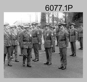
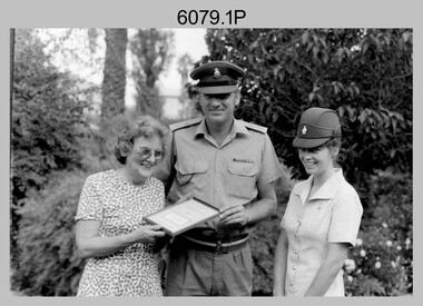
Photograph - Army Survey Regiment – Commanding Officer Handover Parade, Fortuna Villa, Bendigo, 1985
... Army Svy Regt... Survey Regiment Army Svy Regt Fortuna ASR .1P to .6P ...These photographs were taken at a Commanding Officer Handover Parade at the Army Survey Regiment, Bendigo in 1985. LTCOL Jorge Gruszka was the CO of the Army Svy Rgt from 1982 to 1985 and handed over LTCOL Don Swiney MBE. LTCOL Swiney’s appointment was from 1985 to 1987. See item 6475.14P for additional photos taken at the parade.This is a set of six photographs of a Commanding Officer Handover Parade at the Army Survey Regiment, Bendigo in 1985. Photographs .1P to .5P were printed on photographic paper and scanned at 300 dpi. Photograph .6P is on 35mm negative film and scanned at 96 dpi. The photographs are part of the Army Survey Regiment’s Collection. .1) - Photo, black & white, 1985, L to R: MAJ Kym Weston, MAJ Bob Roche, CPL Lyall Camp, LTCOL Jorge Gruszka, CPL Peter Johnson, SGT Terry Danger, SGT Bruce Bowers, SPR Dave Wright, SPR Michael Arnott, SGT Mick Hogan. .2) - Photo, black & white, 1985, L to R: LTCOL Don Swiney MBE, RSM WO1 Bob Mason, LTCOL Jorge Gruszka, MAJ Bob Roche. .3) - Photo, black & white, 1985, L to R: MAJ Mick Byrne, CAPT John South, unidentified, SSGT Steve Egan, CPL Brian Fauth, LTCOL Jorge Gruszka, LTCOL Don Swiney MBE, RSM WO1 Bob Mason. .4) - Photo, black & white, 1985, L to R: MAJ Kym Weston, CAPT Roger Rix, unidentified, CPL Terry ‘TJ’ Wicker, unidentified, SPR Rob Straube, LTCOL Jorge Gruszka, LTCOL Don Swiney MBE, RSM WO1 Bob Mason. .5) - Photo, black & white, 1985, L to R: MAJ Daryl Hockings CSM, LT Greg Oaten, CPL David Jobe, CPL Brian Johnson, 2LT Kathie Ryan, CPL Bob Thrower, LTCOL Jorge Gruszka, LTCOL Don Swiney MBE, RSM WO1 Bob Mason. .6) - Photo, black & white, 1985, L to R: MAJ Terry Edwards, unidentified (x2), SPR Roger Graf, LTCOL Jorge Gruszka, LTCOL Don Swiney MBE, RSM WO1 Bob Mason, MAJ Bob Roche, unidentified..1P to .6P – There are no personnel identifiedroyal australian survey corps, rasvy, army survey regiment, army svy regt, fortuna, asr -
 Bendigo Military Museum
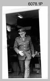
Photograph - LTCOL Jorge Gruszka – Commanding Officer Army Survey Regiment, c1982-1985
... Army Svy Regt... Survey Regiment Army Svy Regt Fortuna ASR .1P to .3P ...These photographs were taken at the Army Survey Regiment, Bendigo in c1985. LTCOL Jorge Gruszka was the Commanding Officer from 1982 to 1985.This is a set of three photographs of LTCOL Jorge Gruszka, CO of the Army Survey Regiment Army Survey Regiment, Bendigo c1982-1985. The photographs were printed on photographic paper and are part of the Army Survey Regiment’s Collection. The photographs were scanned at 300 dpi. .1) - Photo, black & white, c1982-1985, LTCOL Jorge Gruszka. .2) and .3) - Photo, colour, c1982-1985, LTCOL Jorge Gruszka. .1P to .3P – Incorrectly identified on back as George Gruszkaroyal australian survey corps, rasvy, army survey regiment, army svy regt, fortuna, asr -
 Bendigo Military Museum
Photograph - Army Survey Regiment – Presentation to Charity Organisation, c1982
... Army Svy Regt... Australian Survey Corps RASvy Army Survey Regiment Army Svy Regt ...These photographs of a presentation to a charity organisation were taken in the grounds of Fortuna Villa, Army Survey Regiment in c1982. SPR Gae (Robinson) Amato was the unit’s first Miss Golden North entrant in the Miss Australia Quest. LTCOL Peter Eddy and SPR Amato presented a fundraising cheque to the unidentified representative from the Spastic Society. In later years SPR Amato took the opportunity of a new career as a commissioned officer in another Corps of the Australian Army.This is a set of four photographs of a presentation to a charity organisation at the Army Survey Regiment, Bendigo in c1982. The photographs were printed on photographic paper and are part of the Army Survey Regiment’s Collection. The photographic prints were scanned at 300 dpi, however better clarity was achieve scanning 35mm negatives at 96 dpi. .1) to .4) - Photo, black & white, c1982, L to R: unidentified charity organisation representative, LTCOL Peter Eddy, SPR Gae (Robinson) Amato..1P to .2P – No personnel identified .3P to .4P – ‘Gae Robertson MISS AUST 1980s’royal australian survey corps, rasvy, army survey regiment, army svy regt, fortuna, asr -
 Bendigo Military Museum
Photograph - Flag Day - Army Survey Regiment Versus School of Military Survey, 10.10.1986
... Army Svy Regt... Regiment Army Svy Regt Fortuna ASR .1P – annotated with ‘10 Oct 86 ...These photographs were taken at Flag Day, an annual sports competition between the Army Survey Regiment and the School of Military Survey, at Bendigo on the 10th of October 1986. The two RASvy units took turns each year to host the event. The day competition usually comprised basketball, cross country, golf, sailing, squash softball, tennis, touch football, tug-of-war and volleyball. The evening competition often included darts, carpet bowls, hookey, quoits and snooker. The scoreboard in the background in photo .11P indicated an emphatic victory for the Army Survey Regiment.This is a set of 13 photographs of Flag Day, Army Survey Regiment versus the School of Military Survey, at Bendigo on the 10th of October 1986. There are more photographs available on 35mm negatives and 35mm positive proofs. The photographs were printed on photographic paper and are part of the Army Survey Regiment’s Collection. The photographs were scanned at 300 dpi. .1) - Photo, black & white, 1986, Ian ‘Rock’ Thistleton. .2) - Photo, black & white, 1986, L to R: CPL Dave Cook, unidentified (x4), CPL Peter Johnson, unidentified. .3) - Photo, black & white, 1986, L to R: CPL John Smith, Peter Tuddenham, John ‘Stormy Tempest, unidentified, Pat Drury, Mick ‘Buddha’ Ellis, Trevor Roddam, Paul Richards, Warren ‘Waldo’ Shirley. .4) - Photo, black & white, 1986, L to R: unidentified (x2). .5) - Photo, black & white, 1986, Eddy Jacobs - No. 13, Paul Baker – with ball, Brian Fauth – 2nd from right, Daryl South - No. 7. .6) - Photo, black & white, 1986, Rick van Der Bom. .7) - Photo, black & white, 1986, L to R: Leah (Hoffman) Peppler, unidentified, Stu Thaxter. .8) - Photo, black & white, 1986, L to R: SGT Mick Gillham, unidentified (x3), Phil Meagher, Barry Hogan, Jim Walker, Daryl South, WO1 Trevor Osborne, CPL Michelle Griffiths, CPL Sherri (Dally) Burke, SPR Avril (Bray) Lloyd. .9) - Photo, black & white, 1986, L to R foreground: SPR Jan (Crighton) Minchin, CPL Eddy Jacobs .10) - Photo, black & white, 1986, L to R: John ‘Stormy’ Tempest, Mark Donnelly, Paul ‘Hutch’ Hunter, Andy Lucas, foreground unidentified, Lyall Camp, CPL John Martin, SSGT Bob Scaddan. .11) - Photo, black & white, 1986, L to R: CO SMS LTCOL Jim Corless, CO ASR LTCOL Don Swiney MBE, RSM WO1 Jeff Lynch, SGT Wayne Rothwell. .12) - Photo, black & white, 1986, L to R: LTCOL Clem Sargent, RSM WO1 Jeff Lynch, CO ASR LTCOL Don Swiney MBE, SGT Wayne Rothwell. .13) - Photo, black & white, 1986, L to R: LTCOL Clem Sargent, RSM WO1 Jeff Lynch, SGT Wayne Rothwell, CO ASR LTCOL Don Swiney MBE.1P – annotated with ‘10 Oct 86 I. Thistleton’ .2P to .13P –No personnel are identifiedroyal australian survey corps, rasvy, army survey regiment, army svy regt, fortuna, asr -
 Bendigo Military Museum
Photograph - Army Survey Regiment - Regimental Training Field Phase, c1986
... Army Svy Regt... Survey Regiment Army Svy Regt Fortuna ASR .1P to .5P – Personnel ...This is a set of eight photographs of Army Survey Regiment personnel undertaking regimental training in the Wellsford Forest, Bendigo, c1986. The aim of the training was to provide personnel a practical knowledge of infantry and minor tactics at the section level, navigation and map reading, RATEL and Survival in the Field. According to administrative instructions accompanying these photos, Air Survey, Cartographic, Lithographic and Headquarters Squadrons trained separately for one week from April to June 1986. Annotations on the back of photos .1P to .8P indicate Headquarters Squadron’s 4 Section in the ‘Axedale’ Forest. *Note - The forest was incorrectly named – It was most likely the training was in the Wellsford Forest. Sections were established for the period of regimental training only. This is a set of eight photographs of the Army Survey Regiment undertaking regimental training in the Wellsford Forest, Bendigo. c1986. The photographs were printed on photographic paper and are part of the Army Survey Regiment’s Collection. The photographs were scanned at 300 dpi. .1) - Photo, black & white, c1986, SGT Bruce Wetzig. .2) - Photo, black & white, c1986, PTE Tony Seely. .3) - Photo, black & white, c1986, SGT Bill Claydon. .4) - Photo, black & white, c1986, SGT Bill Claydon. .5) - Photo, black & white, c1986, SGT Gregory Smith. .6) - Photo, black & white, c1986, unidentified personnel. .7) - Photo, black & white, c1986, unidentified personnel. .8) - Photo, black & white, c1986, Mack water tanker..1P to .5P – Personnel are identified .6 to .8P – No personnel are identified Annotated ‘4 Section, Headquarters Squadron Axedale Forest’royal australian survey corps, rasvy, army survey regiment, army svy regt, fortuna, asr -
 Bendigo Military Museum
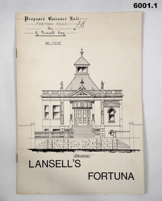
Booklet - Lansell's Fortuna, Army Survey Regiment, Circa 1960
... Army Svy Regt... Army Svy Regt ASR 6001.1 The white covered version is the first ...History of Fortuna Villa covering owners and occupiers, the building and the tour during Army tenure. Mentions original owner Christopher Balderstedt, George Lansell and Royal Australian Survey Corps tenures. A number of different versions of this booklet were produced. Each version had a different colour cover. This orange covered edition was the last version produced and printed.6001.1 The white covered version is the first edition of the Fortuna Tour booklet. 6001.2 The orange and off-white covered booklet is the final edition of the Fortuna Tour booklet produced by the Army Survey Regiment, 36 pages, contains black and white photos, colour photos, plans, sketches, maps, diagrams, gloss paper, stapled spline 20cm x 29cm 6001.3 The green covered edition is a second variation of the Army Survey Regiment Tour Bookletroyal australian survey corps, rasvy, fortuna, army survey regiment, army svy regt, asr -
 Bendigo Military Museum
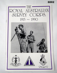
Booklet - Booklet Royal Australian Survey Corps History, " The Royal Australian Survey Corps " 1915-1990, c, 1995
... Army Svy Regt... Survey Corps RASvy Fortuna Army Survey Regiment Army Svy Regt ASR ...This article was presented as a paper to the 1990 Australian War Memorial History Conference to mark the 75th anniversary of the formation of the "Australian Survey Corps" on 1 July 1915. The Corps has since been renamed. Booklet, A4, 13 Pages, Cardboard Cover, Colour, Maps, Photographs, Black and White. Held together by metal staplesroyal australian survey corps, rasvy, fortuna, army survey regiment, army svy regt, asr -
 Bendigo Military Museum
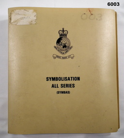
Manual - Symbolisation All Series (Symbas), Specification for maps produced by the Royal Australian Survey Corps, C 1988
... Army Svy Regt... RASvy Fortuna Army Survey Regiment Army Svy Regt ASR Symbas ...Symbas provides the specification (rules) for the collection and compilation of topographic data; the basic instructions for colour preparation and reproduction of topographical detail on maps produced by RASvyPlastic cover, book, beige, 7 chapters, metal clip bindingroyal australian survey corps, rasvy, fortuna, army survey regiment, army svy regt, asr, symbas, specification -
 Bendigo Military Museum
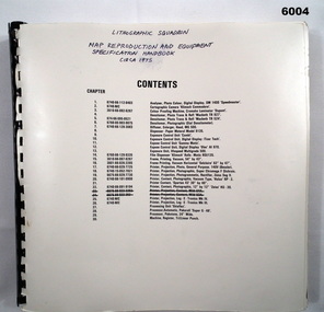
Manual - Map Reproduction and Equipment Specification Handbook, Circa 1975
... Army Svy Regt... Army Svy Regt ASR 90 page technical manual/ handbook. Does ...Manual used by Lithographic Technicians as a register of Map reproduction equipment. Possible uses include to identify and quantify available equipment as part of the stocktaking process.90 page technical manual/ handbook. Does not have a front cover. Contents page and pages within the document have black and white stock descriptions followed by photos of equipment. The manual is printed on photographic paper and is bounded by a black plastic spiral spline.royal australian survey corps, rasvy, fortuna, army survey regiment, army svy regt, asr -
 Bendigo Military Museum
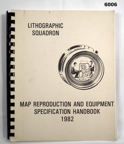
Manual - Map Reproduction and Equipment Specification Handbook, 1982
... Army Svy Regt.... Royal Australian Survey Corps RASvy Fortuna Army Svy Regt ASR ...This handbook provided comprehensive technical information principally to the lithographic technician and to other Royal Australian Survey Corps technical trades. Part 1 comprised technical descriptions and photos of lithographic equipment used in military map production. Part 2 provided various tables such as printing sizes conversion tables. Part 3 provided technical guidance on the stipples and screens utilised in the map reproduction process. Part 4 detailed the Pantone Matching System printing colours for map and chart products. Part 5 was a Glossary of Lithographic Technical Terms.Army Survey Regiment Manual/handbook with a manilla cover comprising approximately 100 pages. The pages in the document are in black and white paper providing technical information and photograph identifying lithographic equipment and other information to lithographic technicians. Printed on standard paper bound by a by a black plastic spiral spline.royal australian survey corps, rasvy, fortuna, army svy regt, asr, army survey regiment -
 Bendigo Military Museum
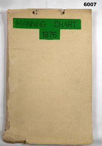
Document - Army Survey Regiment Manning Chart 1976, 1976
... Army Svy Regt... Svy Regt ASR Fortuna Manilla cardboard folder containing 83 ...This document contains detailed photocopies of reports of Army Survey Regiment’s staff manning from December 1975 to August 1976. Each monthly report provided to Directorate of Survey covered the allocation of staff to Regimental Headquarters and its four sub units comprising Headquarters, Air Survey (Topographic), Cartographic and Lithographic Squadrons. Each Squadron’s troop or section structure was represented by a wire diagram with soldiers and/or civilians names assigned to rank based established positions. A detailed table at the end of each report sumarised Army Survey Regiment’s posted strength by employment category and rank.Manilla cardboard folder containing 83 photocopied pages of staff posted to the Army Survey Regiment. Pages are fixed to the folder by a metal fastener. The title of the folder is written in black ink on a green tape background.royal australian survey corps, rasvy, army survey regiment, army svy regt, asr, fortuna -
 Bendigo Military Museum
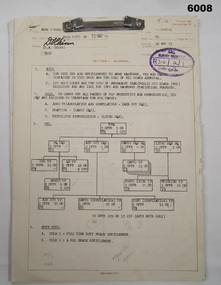
Document - Army Survey Regiment Army and Civilian Establishment Authorisation, 23 05 1975
... Army Svy Regt... Corps RASvy Fortuna Army Survey Regiment Army Svy Regt ASR ...This document was a directive from Army Headquarters authorising the allocation of Army and Civilian positions to the Army Survey Regiment. It provided an organisational wire diagram summarising the overall numbers of Officer, Civilian and Other Ranks to RHQ, and Headquarters, Air Survey, Cartographic and Lithographic Squadrons. Staff allocations to RHQ and each of the four squadron's troop and/or sections were identified in a table format, by hierarchy of rank and employment categories.This document comprises 7 pages of information in black and white with diagrams and tables detailing the allocation of staff to the unit. Pages are fixed by a metal fastener. There is no cover.royal australian survey corps, rasvy, fortuna, army survey regiment, army svy regt, asr -
 Bendigo Military Museum
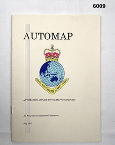
Pamphlet - AUTOMAP - Automation Applied to the Mapping Process, Major Sam Thompson US Army Corps of Engineers, 01.07.1977
... Army Svy Regt... Survey Regiment Army Svy Regt ASR Army Survey Regiment pamphlet ...This pamphlet produced by Major Sam Thompson US Army Engineer Corps on exchange to Australia was published as a guide to AUTOMAP 1, the Army Survey Regiment’s first computer-based map production system. It examined how automation had changed the compilation and drafting phases of the map production process. It attempted to present in a light-hearty story telling style, short and clear description of each AUTOMAP 1 sub-system with photos of staff and equipment, diagrams and humorous cartoons. The cartoonist is unknown. The pamphlet was printed at the Army Survey Regiment, Bendigo Army Survey Regiment pamphlet comprises a manilla card cover printed in colour with 24 pages with photographs in black and white; and descriptions, diagrams, and cartoons printed in colour. It is bounded by two staples on its spine. The coloured pages have been scanned at 300 dpi and are stored on a USB Digital Storage Device. The page images have been converted into a video (.mp4) format and also stored on the USB. The video is 1.3Mb in size and runs for 1.3 minutes.royal australian survey corps, rasvy, fortuna, army survey regiment, army svy regt, asr -
 Bendigo Military Museum
Pamphlet - An Introduction to Topographic Mapping, C 1991
... Army Svy Regt... Army Survey Regiment Army Svy Regt ASR This is a Royal ...This pamphlet was published by the Army Survey Regiment as an overview of the Royal Australian Survey Corps (RASvy), its role and unit structure circa 1991, prior to RASvy’s disbandment in 1996. The pamphlet comprehensively detailed the eight steps of topographic map production: Establish Survey Control, Aerial Photography, Aerotriangulation, Stereoplotting, Field Verification, Cartography, Printing and Storage/Map Distribution. Leading technologies used by RA Svy in 1991 included GPS control surveys, 5 colour printing on the Speedmaster offset press and bulk map packaging using the Map Handling Station (with guillotine). Digital map production was operating on the AUTOMAP 2 system, before the “Newheart” system upgrade two years later. Printed on the pamphlet cover was a portion of the plane tabled “four inches to a mile” map of Newcastle. This was compiled and surveyed in 1910 by LCPL A. Barrett, a member of the RAE Detachment, as part of the first major topographic mapping effort of Australia.This is a Royal Australian Survey Corp pamphlet with a historical map printed in colour on cardboard on both sides of the cover. There are 16 pages printed in colour on gloss paper, with photos, diagrams and descriptions. The pamphlet is bounded by two staples on its spine. Each of the 17 images were scanned at 300 dpi in JPEG (.jpg) format and stored on the attached 16 Gb USB memory stick. The images have been converted into MPEG-4 (.mp4) video format, 4Mb in size and runs for 2:16 minutes and is also stored on the memory stick.royal australian survey corps, rasvy, fortuna, army survey regiment, army svy regt, asr -
 Bendigo Military Museum
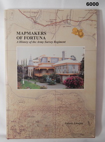
Book - Mapmakers of Fortuna, a History of the Army Survey Regiment, Ex Fortuna Survey Association Inc, 2003
... Army Svy Regt... Australian Survey Corps RASvy Army Survey Regiment Army Svy Regt ASR ...Covers the arrival of the Land Headquarters Cartographic Company at Fortuna Villa in 1942 until the disbandment of the Army Survey Regiment in 1996. Written by Valerie Lovejoy as part of her Masters degree at La Trobe University, BendigoUnit History of the Army Survey Regiment by Valerie Lovejoy, ISBN: 0-646-42120-4, 234 pages, 9 Chapters, 6 Appendices, Black and White photographs, Colored map extracts, Colored cover jacket, hard cover, nominal roll of Unit members.On first page, "Donated to Bendigo RSL Museum by Ex Fortuna Survey Association Inc 21 April 2022"royal australian survey corps, rasvy, army survey regiment, army svy regt, asr -
 Bendigo Military Museum
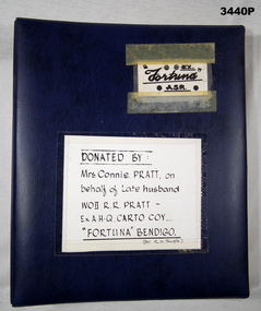
Album - Photo Album of 31074 Warrant Officer Class 2 RR Pratt RASvy, c.WWII onward
... Army Svy Regt... Army Svy Regt ASR Top right side on a white label in black ...This album contains numerous items in relation to the Army Survey Regiment & WOII R R PRATT, WWII onward. Cards, drawings, magazines, souvenirs, caricatures, newspaper clippings, some photos of Bendigo Historical Society objects. Robert Richard PRATT VX85798 enlisted in the 2nd AIF on 8.8.1942 age 28 years. He was discharged from the AIF on 29.10.1947 with the rank of Sgt serving with AHQ Cartographic Coy. He then enlisted in the ARA with a Regimental Number of 31074. He was promoted WOII on 27 May 1948.Blue hard cover photo album with spiral binding. Top right side on a white label in black print: EX FORTUNA ASR In the centre on a white label in black print: Donated by Mrs Connie PRATT on behalf of late husband WOII R R PRATT Ex AHQ CARTO COY "FORTUNA" BENDIGO (Per R O Temple)royal australian survey corps, rasvy, fortuna, army survey regiment, army svy regt, asr -
 Bendigo Military Museum
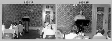
Photograph - Army Survey Regiment Open Day - Briefings and Tours, Fortuna, Bendigo, 1990
... Army Svy Regt... Australian Survey Corps RASvy Army Survey Regiment Army Svy Regt ...These 27 photographs were taken at an Army Survey Regiment Open Day at Fortuna Villa, Bendigo on the 24th of February 1990. This occasion was one of several events held to commemorate the 75th anniversary of the formation of the Royal Australian Survey Corps. Although historical tours of Fortuna occurred on a regular basis, this was the first technical open day since 1972. The Royal Australian Survey Corps recognised that an Open Day was the best way for the local community in Bendigo to gain an insight into the unit’s important role as Defence’s map production agency, its technical equipment, and its economic importance to Bendigo. It also gave them an opportunity to tour through historic Fortuna Villa. This occasion is covered in more detail in page 143 of Valerie Lovejoy’s book 'Mapmakers of Fortuna – A history of the Army Survey Regiment’ ISBN: 0-646-42120-4. Refer to items 6435.35P and 6436.18P for more photos of the Open Day taken in the Map Production areas of Air Survey and Cartographic Squadron, and production areas of Lithographic Squadron. Photo prints of some of these photos were scanned and catalogued in items 6247.30P and 6291.6P.These 27 photographs were taken at an Army Survey Regiment Open Day held at Fortuna, Bendigo on the 24th of February 1990. The 35mm colour and black & white negatives photographs were scanned at 96 dpi and are part of the Army Survey Regiment’s Collection. .1) & .2) - Photo, black & white, 1990. Ballroom - Visitor briefings by CO LTCOL Rene van den Tol. .3) - Photo, colour, 1990. Ballroom - Visitor briefings by MAJ Ray Redman. .4) - Photo, colour, 1990. Ballroom - Visitor briefings by unidentified UK Exchange officer. .5) - Photo, black & white, 1990. Music Room - Visitor briefings by MAJ Bob Williams. .6) - Photo, black & white, 1990. Orderly Room - ADJT CAPT Peter Parkes. .7) - Photo, colour, 1990. Music Room - ADJT CAPT Peter Parkes with civilian visitors. .8) - Photo, colour, 1990. Music Room - Visitor briefings by CPL Le-Anne (Smallshaw) Shirley. .9) - Photo, colour, 1990. Entrance Foyer - Visitor briefings. .10) - Photo, colour, 1990. CO’s Office - Visitor briefings by CPL Raelene (Munting) Brodie. .11) - Photo, colour, 1990. Mr Pat Thwaites outlining utilisation of satellite imagery to civilian visitors. .12) - Photo, black & white, 1990. Mr Pat Thwaites outlining utilisation of satellite imagery to civilian visitors. .13) - Photo, colour, 1990. Staircase leading up to the top floor - Visitor briefings by CPL Ian Nelson. .14) - Photo, colour, 1990. Building 16 - Visitor briefings by RSM WO1 Neville Stone. .15) - Photo, colour, 1990. Civilian visitors enjoying views of the garden from Fortuna Villa’s rooftop. .16) - Photo, black & white, 1990. Visitor briefings at Fortuna’s rear steps. .17) - Photo, black & white, 1990. Outside Building 16 - Visitor briefings by WO1 Gary Warnest. .18) - Photo, colour, 1990. Outside Building 16 - Visitor briefings by WO2 Adrian ‘Charlie’ Creedy. .19) - Photo, colour, 1990. Outside Building 16 - L to R: SPR Sue (Foote) Bourne, LCPL Sandy Winn, WO2 Adrian ‘Charlie’ Creedy. .20) - Photo, colour, 1990. Outside Building 16 - SGT Greg Byers. .21) - Photo, colour, 1990. Visitors enjoying Devonshire Tea in the gardens next to the Tavern. .22) - Photo, colour, 1990. RSM WO1 Neville Stone and family enjoying Devonshire Tea in the gardens next to the Tavern. .23) - Photo, colour, 1990. Visitors relaxing in the garden next to Fortuna’s lake. .24) - Photo, black & white, 1990. CPL Trevor Poll and others serve up BBQ lunch next to the tennis courts. .25) to .27) - Photo, colour, 1990. Parking at a premium inside the Army Survey Regiment and Chum Street..1P to .27P – no annotationsroyal australian survey corps, rasvy, army survey regiment, army svy regt, fortuna, asr -
 Bendigo Military Museum
Administrative record - Artillery Training No24 - The employment of Survey Batteries RAA in the Field, HQ RAA 6 Aust Div, 4 Dec 1944
... Army Svy Regt... Survey Regiment Army Svy Regt ASR Royal Australian Artillery RAA ...Royal Australian Artillery (RAA) Survey Batteries in the field worked in conjunction with the Australian Survey Corps. This document provides guidance for that interaction. This document was onforwarded to the ExFortuna Survey Association from 4 Fd Svy Sqn in Aug 2024.18 pages of typed notes on letter sized paper, stapled top left corner. This is a photocopy of an original that is held at the Australian War Memorial ACT (AWM 52)royal australian survey corps, rasvy, fortuna, army survey regiment, army svy regt, asr, royal australian artillery, raa -
 Bendigo Military Museum
Administrative record - The Airborne Profile Recorder (APR) Ballarat Test Area, Captain EP Constantine RASvy, Circa 1962
... Army Svy Regt... Army Survey Regiment Army Svy Regt ASR 21 x pages of typed text ...The Airborne profile Recorder (APR) is a precise airborne radar altimeter designed to provide a continuous record of terrain clearance, (the distance between the aircraft and the ground surface). This document was condensed from a report by Captain E P Constantine RASvy Corps to test the viability of using APR for acquiring height information for mapping purposes. This document was on forwarded to the ExFortuna Survey Assoc by 4 Fd Svy Sqn in Aug 2025.21 x pages of typed text and diagrams on letter sized paper, stapled top left corner. Three and four hole punched.royal australian survey corps, rasvy, fortuna, army survey regiment, army svy regt, asr -
 Bendigo Military Museum
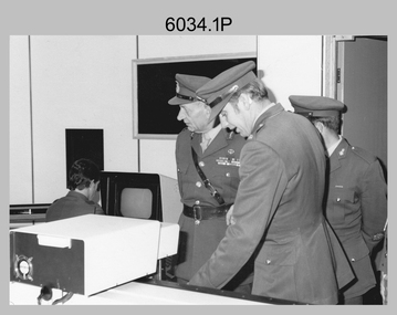
Photograph - Visit by the Chief of the General Staff to the Army Survey Regiment, Fortuna, Bendigo, 1979
... Army Svy Regt... Army Survey Regiment Army Svy Regt Fortuna ASR .1P to .14P ...This is a set of 14 photographs of a visit to the Army Survey Regiment, Fortuna, Bendigo on the 5th of June 1979 by the Chief of the General Staff (CGS) Lieutenant General Sir Donald Dunstan AC, KBE, CB. He was accompanied by his wife. They were escorted through the production areas of the Army Survey Regiment by the CO LTCOL Bob Skitch. Lieutenant General Sir Donald Dunstan AC, KBE, CB was an esteemed Australian Army officer, who was CGS from 1977 to 1982. Upon retirement from the Army in 1982, he was appointed to the position of Governor of South Australia from 1982 to 1991. LTCOL Bob Skitch was the CO of the Army Svy Rgt from 1976 to 1980. Also featuring in these photos is MAJ Peter Eddy, who was the OC of Air Survey Squadron. He was later promoted to LTCOL and was CO of the Army Svy Rgt from 1981 to 1982. See item 6035.9P for photos of the CGS’s presentation of the Defence Force Service Medal to four recipients.This is a set of 14 photographs of a visit by the Chief of the General Staff to the Army Survey Regiment Fortuna, Bendigo on the 5th of June 1979. The photographs were printed on photographic paper and are part of the Army Survey Regiment’s Collection. They were scanned at 300 dpi. .1) - Photo, black and white, 1979. Tour of Air Survey Squadron. L to R: unidentified, LTGEN General Sir Donald Dunstan AC, KBE, CB; OC MAJ Peter Eddy, unidentified. .2) - Photo, black and white, 1979. Tour of Air Survey Squadron. LTGEN General Sir Donald Dunstan AC, KBE, CB; views 3D stereoscopic aerial photography on a Zeiss (Jena) Stecometer. OC MAJ Peter Eddy is on his right. .3) - Photo, black and white, 1979. Tour of Air Survey Squadron. L to R: unidentified, CO LTCOL Bob Skitch, OC MAJ Peter Eddy, LTGEN General Sir Donald Dunstan AC, KBE CB viewing an aerial photograph. WO1 Brian Mead and others are operating a Wild PUG4 point transfer device. .4) - Photo, black and white, 1979. Enlargement of photo .3). Tour of Air Survey Squadron. L to R: unidentified, CO LTCOL Bob Skitch, OC MAJ Peter Eddy, LTGEN General Sir Donald Dunstan AC, KBE CB viewing an aerial photograph. .5) - Photo, black and white, 1979. Tour of Air Survey Squadron. LTGEN General Sir Donald Dunstan AC, KBE, CB; and unidentified technician view 3D stereoscopic aerial photography on a Wild B8 stereo plotter. .6) - Photo, black and white, 1979. Tour of Air Survey Squadron. L to R: OC MAJ Peter Eddy LTGEN General Sir Donald Dunstan AC, KBE CB; CO LTCOL Bob Skitch, view the output of a verification plot on an AUTOMAP 1 Gerber 1442 drum plotter. .7) - Photo, black and white, 1979. Tour of Air Survey Squadron. L to R: CO LTCOL Bob Skitch, unidentified aide de camp officer, LTGEN General Sir Donald Dunstan AC, KBE CB; OC MAJ Peter Eddy discuss aero triangulation planning documents. CAPT Don Maskew in background. .8) - Photo, black and white, 1979. Tour of Cartographic Squadron. L to R: CPL Dennis Learmonth, acting OC CAPT Bob Roche, CAPT Eddy Schulze, LTGEN General Sir Donald Dunstan AC, KBE CB; SSGT John ‘JB’ Barrie discuss cartographic map compilation procedures .9) - Photo, black and white, 1979. Tour of Cartographic Squadron. L to R: Tech WO WO1 Roger Rix, acting OC CAPT Bob Roche, CAPT Eddy Schulze, unidentified visitor, Mrs Dunstan with examples of map products. .10) - Photo, black and white, 1979. Tour of Cartographic Squadron. L to R: CPL Terry Danger, CO LTCOL Bob Skitch, LTGEN General Sir Donald Dunstan AC, KBE CB; discuss terrain embossing (hill shading) procedures. .11) - Photo, black and white, 1979. Tour of Cartographic Squadron. L to R: CO LTCOL Bob Skitch, LTGEN General Sir Donald Dunstan AC, KBE CB; acting OC CAPT Bob Roche, SSGT Dick Manley, CAPT Don Maskew and CAPT Steve Cooper in background. SPR Cheryl Lofthouse is retouching blemishes on a map separation film negative. .12) - Photo, black and white, 1979. Tour of Lithographic Squadron. L to R: CAPT Stan Vote, unidentified aide de camp officer, CO LTCOL Bob Skitch, LTGEN General Sir Donald Dunstan AC, KBE CB; MAJ Sam Schwartz EXCH-US, LT John Harrison discuss bulk map printing processes with an Ultra-MAN-III Printing Press. .13) - Photo, black and white, 1979. Officers Mess L to R: LTGEN General Sir Donald Dunstan AC, KBE CB; with CO LTCOL Bob Skitch. .14) - Photo, black and white, 1979. Officers Mess L to R: MAJ Peter Eddy, LTGEN General Sir Donald Dunstan AC, KBE CB..1P to .14P – no annotationsroyal australian survey corps, rasvy, army survey regiment, army svy regt, fortuna, asr -
 Bendigo Military Museum
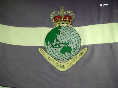
Flag - Royal Australian Survey Corps Flag - Army Survey Regiment, Mid to late 1970's
... Army Svy Regt... Fortuna Army Survey Regiment Army Svy Regt ASR A full size Corps ...Survey Corps Flags of this type were produced mid to late 1970's and distributed to all Survey Corps Units. This flag was issued to the Army Survey Regiment, Bendigo and flew during daylight hours on the Unit flag pole at Fortuna Villa for many years. The flag was ceremonially marched out of the gate on the day that the Army Survey Regiment was disbanded in 1996. Leading the flag bearer party is the Commanding Officer of the Army Survey Regiment LTCol Duncan Burns followed by the band of the Fortuna Pipes and Drums.A full size Corps Flag, purple with 18cm horizontal white stripe. Multi-coloured Survey Corps Badge (less scroll) in the centre of the flag. White header with grommets top and bottom.royal australian survey corps, rasvy, fortuna, army survey regiment, army svy regt, asr -
 Bendigo Military Museum
Photograph - Army Survey Regiment Group Photos, Fortuna Villa, Bendigo, 1990
... Army Svy Regt... Army Svy Regt Fortuna ASR .1P to .11P – no annotations ...This is a set of 11 photographs of personnel posted to the Army Survey Regiment in 1990. These formal group photos of three of the four Squadrons, Officers, and Warrant Officers/Sergeants were probably taken after CO’s Parades. Although photo .11P is part of this set of negatives, it was taken on another occasion as the SGTs Mess personnel were in summer uniforms. Photos of Lithographic Squadron from this set of negatives are catalogued in item 6441.15P. LTCOL John Winzar was the CO of the Army Survey Regiment from 1987 to 1989 and WO1 Neville Stone was the RSM from 1988 to 1990.This is a set of 11 photographs of personnel posted to the Army Survey Regiment, Fortuna Villa, Bendigo Victoria on the 1st of October 1990. The photographs are on 35mm negative film and were scanned at 96 dpi. They are part of the Army Survey Regiment’s Collection. .1) to .2) - Photo, black & white, 1990. Senior appointments: L to R: RSM WO1 Neville Stone, CO LTCOL Rene van den Tol, 2IC MAJ Duncan Burns, ADJT CAPT Peter Parkes. .3) - Photo, black & white, 1990. Officers Mess: Back row L to R: back row L to R: LT Craig Hersant, LT Greg Tolcher, LT Martin Lyons, LT Steve Hledik, LT Derek Bell, LT Simon Buckpitt. Centre row L to R: CAPT Roger Greenwell, CAPT Dave McLachlan, ADJT CAPT Peter Parkes, unidentified UK exchange officer, CAPT Noel ‘Nesty’ Coulthard. Front row L to R: CAPT John South, MAJ Bob Coote, MAJ Neil Taylor, CO LTCOL Rene van den Tol, 2IC MAJ Duncan Burns, MAJ Peter Clark, MAJ Ray Redman. .4) - Photo, black & white, 1990. SGTs Mess: Back row L to R: SGT Max Watson, unidentified, SGT Martin Evans, SSGT Graham Johnston, SGT Brian Fauth, SGT Ian Fitzgerald, unidentified, SGT Mick Minchin, SGT Kim Reynolds, SGT Peter Imeson, SGT Brian Paul, SSGT John Phillips, SGT Keith Quinton, unidentified (x2), SSGT Noel McNamara, SGT Paul Hopes, SGT Brendan McKinless. 3rd row L to R: SSGT Di Chalmers, SGT Bob Bright, SGT Doug Carswell, WO2 Steve Egan, unidentified, SSGT Garry Drummond, SGT Steve Burke, SSGT Russ Mollenhauer, SGT Paul Cheater, SGT Sandy Craig, SSGT Peter Mustart, SGT Roger Rees, SGT Paul Leskovec CSM, unidentified, SGT John Shephard, SGT Frank Downie, SSGT Bruce Hammond, unidentified. 2nd row L to R: WO2 Jeff Willey, WO2 Barry Lutwyche OAM, WO2 Rob Bogumil, WO2 Rhys De Laine, WO2 Ted Burgess, WO2 Wayne Rothwell, WO2 Steve Hansen, WO2 Keith Fenton RE UK Exchange, SGT Chris Edwards, SGT Russ Mollenhauer, unidentified, SGT Greg Else, unidentified, SSGT Bob Garritty, SSGT Greg Byers, WO2 Pat Lumsden, WO2 George Graham, WO2 Mick Hogan, SGT Sherri (Dally) Burke. Front row L to R: WO1 Trevor Osborne, WO1 Colin Cuskelly, WO1 Bob Rogister, WO1 Allan Hancox, WO1 Bill Jones, 2IC MAJ Duncan Burns, RSM WO1 Neville Stone, WO2 Neil ‘Ned’ Kelly, WO1 Ken Slater, WO1 Rowan Gillies, WO1 Graham Ragless, WO1 Gary Warnest, WO2 Adrian ‘Charlie’ Creedy. .5) - Photo, black & white, 1990. Air Survey Squadron: Back row L to R: SPR Mark Linwood, SPR Trevor Roddam, CPL Noel Brinsmead, CPL Mark Lander, SGT Frank Downie, CPL Sandy Craig. 3rd row L to R: SPR Steve Rundle, SPR Cameron Gee OAM, CPL Darren Wilkinson, CPL Dave Longbottom, CPL Max Watson, SPR Shane Torrens, SGT Paul Hopes, SPR Chris Woodman. 2nd row L to R: SGT John Shephard, SPR Paul Boulton, SPR Stuart Bowd, SPR Paula (Golding) Brinsmead, SPR Joanne Otto, CPL Steve Coulson, SPR Steve Linane, CPL Chris ‘Charlie’ Brown. Front row L to R: SSGT Bruce Hammond, WO2 Barry Lutwyche OAM, LT Craig Hersant, WO1 Allan Hancox, MAJ Peter Clark, LT Simon Buckpitt, WO2 Neil ‘Ned’ Kelly, SSGT SSGT Noel McNamara. .6) - Photo, black & white, 1990. Headquarters Squadron: Back row L to R: unidentified (x2), SPR Wolfgang Hofbauer, SGT Chris Edwards, CPL Pat Drury, SSGT John Phillips, unidentified, CPL Graeme Priestley, unidentified (x2), SGT Paul Leskovec CSM, LCPL Richard Arman. 4th row L to R: unidentified, SGT Ian Fitzgerald, unidentified (x2), LCPL Bob Sheppard, unidentified (x2), CPL John ‘Flash’ Anderson, SPR Todd Reynolds, SGT Keith Quinton, CPL Roger Pearson, unidentified, WO1 Bob Rogister. 3rd row L to R: WO2 Wayne Rothwell, SSGT Peter Mustart, SPR Eric Nicholson, unidentified, SGT Paul Cheater, unidentified, SGT Wolfgang Thun, unidentified (x2), CPL Paul Richards, SGT Mick Minchin, unidentified. 2nd row L to R: unidentified, SPR Kasey Northausen, unidentified, CPL Michelle Griffith, unidentified (x3), SPR Tracy Tillman, unidentified (x4), WO2 Steve Hansen. Front row L to R: WO1 Rowan Gillies, WO1 Colin Cuskelly, CAPT Noel ‘Nesty’ Coulthard, CAPT Roger Hancock, WO1 Ken Slater, MAJ Ray Redman, MAJ John South, unidentified UK exchange officer, WO2 Ted Burgess, WO2 George Graham, unidentified civilian. .7) & .8) - Photo, black & white, 1990. Cartographic Squadron: Back row L to R: Back row L to R: SGT Greg Else, CPL Perry Burt, SSGT Graham Johnston, CPL Mick McConnell, 3rd row L to R: SGT Bob Bright, SGT Doug Carswell, SPR Marcus Seecamp, CPL John Gilbert. 2nd row L to R: SGT Martin Evans, SPR Sandy Winn, SPR Jeanette Drury-Lane, SPR Simone Rodgers, Front row L to R: SPR Guenther Ebenwaldner, WO2 Pat Lumsden, LT Steve Hledik. .9) - Photo, black & white, 1990. Cartographic Squadron: Back row L to R: SGT Greg Else, CPL Perry Burt, SSGT Graham Johnston, CPL Mick McConnell, unidentified, SPR Mark Linwood, SPR Lee Palfrey, SPR John ‘Doc’ Commons, SPR Chris Wynn, SPR Mick Duggan, CPL Peter Johnson, SPR Allan Blake, CPL Damian Killeen, SPR Grant Davis, SPR Simon Reynolds, SPR Peter Smyth. 3rd row L to R: SPR Guenther Ebenwaldner, SGT Bob Bright, SGT Doug Carswell, SPR Marcus Seecamp, CPL John Gilbert, SPR Gordon Santo, SPR Frank Savy, SPR Chris Woodman, SSGT Greg Byers, SPR David Lankshear, SSGT Bob Garritty, CPL Craig Kellet, CPL Darren Maher, CPL Barry Hogan, CPL Dan Cirsky, SPR Bob Bousfield. 2nd row L to R: SGT Martin Evans, CPL John Reid, SPR Sandy Winn, SPR Jeanette Drury-Lane, SPR Simone Rodgers, SPR Cam Bramich, SPR Ailsa (Sorby) Miller, SPR Nadine (Paul) Read, SPR Jodi Seath, SGT Sherri (Dally) Burke, SPR Di (Thomas) Soutar, SPR Dawn Hoadley, CPL Raelene (Munting) Brodie, SPR Jo (Innes) Thun? SPR Damian Nolan. Front row L to R: WO2 Pat Lumsden, LT Steve Hledik, LT Derek Bell, CAPT Dave McLachlan, MAJ Neil Taylor, WO1 Graham Raglass, WO1 Gary Warnest, WO2 Mick Hogan, WO2 Adrian ‘Charlie’ Creedy. .10) - Photo, black & white, 1990. Cartographic Squadron leadership: Back row L to R: CAPT Dave McLachlan, LT Derek Bell, LT Steve Hledik, WO2 Pat Lumsden, WO2 Mick Hogan, WO2 Adrian ‘Charlie’ Creedy. WO1 Gary Warnest. Front row L to R: MAJ Neil Taylor, WO1 Graham Raglass. .11) - Photo, black & white, 1990. SGTs Mess: Back row L to R: WO2 Jeff Willey, unidentified, SGT Brian Fauth, unidentified, SGT Sandy Craig, unidentified, SGT Paul Leskovec CSM, SSGT John Phillips, unidentified, SGT Martin Evans, SGT Steve Burke, SGT Brendan McKinless, SGT Chris Edwards. 3rd row L to R: SGT Brian Paul, unidentified, SSGT Bob Garritty, SSGT Greg Byers, SGT Kim Reynolds, SGT John Reid, unidentified, SSGT Rick van der Bom, SGT Dale Hudson, unidentified, SGT John ‘Stormy’ Tempest, SGT Keith Quinton, SGT Greg Else. 2nd row L to R: WO2 Rob Bogumil, unidentified, WO2 Adrian ‘Charlie’ Creedy, WO2 George Graham, WO2 Wayne Rothwell, WO2 Pat Lumsden, WO2 Mick Flynn, WO2 Ted Burgess, unidentified, SSGT Dennis Learmonth, SGT Bob Bright, WO2 Steve Hansen, WO2 Rhys De Laine. Front row L to R: unidentified, WO1 Trevor Osborne, WO1 Bill Jones, WO1 Colin Cuskelly, MAJ Ray Redman, RSM WO1 Neville Stone, WO1 Stu Thaxter, WO2 Mick Hogan, WO1 Bob Rogister, WO1 Ken Slater, WO1 Gary Warnest..1P to .11P – no annotationsroyal australian survey corps, rasvy, army survey regiment, army svy regt, fortuna, asr -
 Bendigo Military Museum
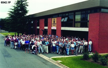
Photograph - 4 Fd Svy Sqn Closure Ceremony 25 Nov 1995, 4 Fd Svy Sqn, Keswick Barracks, Adelaide, 25.11.1995
... Army Svy Regt... Regiment Army Svy Regt ASR 4 Fd Svy Sqn .1P A4 Print of an original ...Between 1915 and 1951, military topographical mapping in SA was conducted by Royal Australian Survey Corps (RASvy) units based outside the state. In February 1952, Army HQ Field Survey Section (Central Command Detachment) was established in Adelaide in a drill hall at Largs Bay. It was tasked with providing map coverage in the Woomera and Southern areas of the state. The section was subsequently reorganised as Central Command Field Survey Section moving firstly to Hampstead Barracks, Hampstead in 1953 and then into accommodation at Keswick Barracks in 1954. In 1957 the Section commenced mapping operations in the NT. The Unit was relocated to the old cavalry stables in 1961 and was redesignated Central Command Survey Unit and remained there till 1973. In 1970 the Unit was redesignated 4 Fd Svy Sqn and engaged in operations conducted in PNG from 1972 to 1974 inclusive. In 1973 the Squadron moved into a brand new two-storey specially designed and purpose built building adjacent to the old building. The old building then became the Squadron Q and Map store with an interconnecting lobby to the new building. Since 1975 the Unit was involved in the 1:50,000 Mapping Programme in WA, NT, QLD, SA and conducted many other operations within Australia and overseas. Post disbandment of the Corps the old Squadron building (cavalry stables) now houses the Army Museum of South Australia (AMOSA). The Royal Australian Survey Corps was amalgimated into the Royal Australian Engineer Corps in July 1996. In the lead up to this amalgamation, 4 Field Survey Squadron Keswick Barracks, Adelaide, South Australia was disbanded in 1995. A closing Ceremony was held on 25 November 1995 at 4 Fd Svy Sqn Keswick Barracks attended by about 208 former members of the Unit. A photo was taken of attendees at that event on the day and a list was prepared of attendees. All attendees were sent a copy of the photograph and the list of names as a momento of the Unit and the ceremony..1P A4 Print of an original photo of attendees at the 4 Fd Survey Sqn Closure Ceremony at Keswick Barracks 25 Nov 1995. .2P A4 Print of the names of the attendees at the 4 Fd Survey Sqn Closure Ceremony at Keswick Barracks 25 Nov 1995. Approx 208 attendees.royal australian survey corps, rasvy, fortuna, army survey regiment, army svy regt, asr, 4 fd svy sqn -
 Bendigo Military Museum
Photograph - Army Survey Regiment – Corps Day Parade, Fortuna Villa, Bendigo, 1995
... Army Svy Regt... Survey Corps RASvy Army Survey Regiment Army Svy Regt Fortuna ASR ...This set of 23 photographs were taken at the Corps Day Parade held at the Army Survey Regiment, Bendigo on the 1st of July 1995. This occasion was to commemorate the 80th anniversary of the formation of the Royal Australian Survey Corps. The Parade Commander was CO LTCOL Duncan Burns, and the Reviewing Officer was the Deputy Chief of the Defence Force MAJGEN G.D. Carter AM. Also in attendance was his MA MAJ M.D. Bornholt AM and the COL COMDT of the Royal Australian Survey Corps COL Don Swiney MBE. On this occasion the Reviewing Officer presented the Defence Force Service Medal to SGT Graham Hales and SPR Ken Labouchardiere for 15 years of efficient remunerated service in the Australian Army. SSGT Russ Mollenhauer received the Defence Force Service Medal clasp in recognition of 20 years of service. SGT Stuart Symonds received his second Defence Force Service Medal clasp in recognition of 25 years of service.This is a set of 23 photographs of the Corps Day Parade held at the Army Survey Regiment, Fortuna, Bendigo on the 1st July 1995. The colour photographs were printed on photographic paper and are part of the Army Survey Regiment’s Collection. The photographs were scanned at 300 dpi. .1) - Photo, colour, 1995. Fortuna Pipes and Drums lead the Army Survey Regiment onto the parade ground. .2) to .3) - Photo, colour, 1995. Fortuna Pipes and Drums in position on the parade ground. .4) - Photo, colour, 1995. Data Acquisition Squadron marches onto the parade ground, led by L to R: WO2 Peter Imeson, WO2 Bruce Hammond. .5) - Photo, colour, 1995. Data Acquisition Squadron front rank L to R: WO2 Peter Imeson, SPR Stuart Catharall, CPL Damien Killeen, CPL Trevor King, SPR Glen Norrell, SPR Kim Baker, SPR Craig Smith, LCPL Mark Fedden, SGT Graham Hales, SPR Josh Andrews OAM, unidentified (x2), WO2 Bruce Hammond. .6) - Photo, colour, 1995. Army Survey Regiment in position on the parade ground. On left - Product Construction Squadron rear rank L to R: CPL Dave Scott, SPR Shane Campbell, CPL Guenther Ebenwaldner, remainder unidentified. Centre rank L to R: CPL Ian Bowes, remainder unidentified. RSM WO1 Ken Johnston OAM MM. Front rank L to R: WO2 Alan Virtue, SSGT Bob Thrower, CPL Paul Einam, SGT Peter Tuddenham, SPR Dik Brierley, SGT Stuart Ridge, SPR Mick Muzeen, SPR Marty Stradbrook, unidentified, SGT Steve Nokes, SPR James Commons, SPR Lance Hillier. WO2 Gill Park. In centre - Administration Support Squadron. On right - Data Acquisition Squadron. 7.) - Photo, colour, 1995. Officers ready to take posts. L to R: LT Dave Sapparth, CAPT Colin Davidson, CAPT Tony Harder – UK Exchange Officer, LT Jason Selman, CAPT Doug Arman, QM CAPT Bill Griggs, LT Roger Grose, CAPT Bin Fashar Sutimin – Indonesian Exchange Officer in white uniform, MAJ Ross Jenkins, CAPT Gary Warnest. 8.) - Photo, colour, 1995. CO LTCOL Duncan Burns salutes the Reviewing Officer MAJGEN G.D. Carter AM. .9) & .10) - Photo, colour, 1995. Data Acquisition Squadron presents arms. Officers’ rank L to R: CAPT Tony Harder – UK Exchange Officer, CAPT Colin Davidson, LT Dave Sapparth. ADJT CAPT Brenton McDonald at far right. Front rank L to R: WO2 Peter Imeson, SPR Stuart Catharall, CPL Damien Killeen, CPL Trevor King, SPR Glen Norrell, SPR Kim Baker, SPR Craig Smith, LCPL Mark Fedden, SGT Graham Hales, SPR Josh Andrews OAM, unidentified (x2), WO2 Bruce Hammond. 11) - Photo, colour, 1995. Army Survey Regiment presenting arms. L to R: Product Construction Squadron, Administration Support Squadron, Data Acquisition Squadron. .12) - Photo, colour, 1995. Product Construction Squadron presents arms. Officers’ Rank: 2IC MAJ Mick Banham, L to R: CAPT Gary Warnest, OC MAJ Ross Jenkins CAPT Bin Fashar Sutimin – Indonesian Exchange Officer, LT Roger Grose. L to R: RSM WO1 Ken Johnston OAM MM. Front rank L to R: SSGT Bob Thrower, CPL Paul Einam, SGT Peter Tuddenham, SPR Dik Brierley, SGT Stuart Ridge, SPR Mick Muzeen, SPR Marty Stradbrook, unidentified, SGT Steve Nokes, SPR James Commons, SPR Lance Hillier, WO2 Gill Park. Other identifiable personnel in rear ranks L to R: SGT Peter Tuddenham, SPR Ben Lucas, SPR Dik Brierley, SGT Dale Hudson, SPR Annette (Odgers) Wynn, CPL Roger Pearson, SPR Corey Hill, SSGT Russ Mollenhauer. 13) - Photo, colour, 1995. Army Survey Regiment Advances in Review Order. L to R: Product Construction Squadron, Administration Support Squadron, Data Acquisition Squadron. 14) - Photo, colour, 1995. Army Survey Regiment in rank formation slow marches around parade ground L to R: Product Construction Squadron, Administration Support Squadron, Data Acquisition Squadron. .15) & .16) - Photo, colour, 1995. Data Acquisition Squadron slow marches, using ‘Forms’ to turn right in rank formation. Officers’ rank L to R: CAPT Tony Harder – UK Exchange Officer, CAPT Colin Davidson, LT Dave Sapparth. ADJT CAPT Brenton McDonald at far right.front rank L to R: WO2 Peter Imeson, SPR Stuart Catharall CPL Damien Killeen, CPL Trevor King, SPR Glen Norrell, SPR Kim Baker, SPR Craig Smith, LCPL Mark Fedden, SGT Graham Hales, SPR Josh Andrews OAM, unidentified (x2), WO2 Bruce Hammond. Centre Right Marker SPR Cameron Gee OAM is behind SPR Stuart Catharall. .17) - Photo, colour, 1995. Data Acquisition Squadron proceeds past Reviewing Officer on ‘Eyes Right’ command. Officers’ rank L to R: CAPT Tony Harder – UK Exchange Officer, LT Dave Sapparth. CAPT Colin Davidson. Centre Right Marker SPR Cameron Gee OAM. Right rear supernumerary SSGT Rod Skidmore, ADJT CAPT Brenton McDonald to his left. Front rank L to R: WO2 Peter Imeson, SPR Stuart Catharall CPL Damien Killeen, CPL Trevor King, SPR Glen Norrell, SPR Kim Baker, SPR Craig Smith, LCPL Mark Fedden, SGT Graham Hales, SPR Josh Andrews OAM, unidentified (x2), WO2 Bruce Hammond. CO LTCOL Duncan Burns in foreground. .18) - Photo, colour, 1995. Data Acquisition Squadron proceeds past Reviewing Officer on ‘Eyes Right’ command. Rear rank L to R: unidentified, CPL John ‘Doc’ Commons, CPL Tony Jackson, SPR Helen Scorgie. Centre rank L to R: SPR Cameron Gee OAM, SPR Derek Percival, SPR Grant Lloyd. Front rank L to R: WO2 Peter Imeson, SPR Stuart Catharall CPL Damien Killeen, CPL Trevor King, SPR Glen Norrell, SPR Kim Baker, SPR Craig Smith, LCPL Mark Fedden, SGT Graham Hales, SPR Josh Andrews OAM, unidentified (x2), WO2 Bruce Hammond. .19) - Photo, colour, 1995. L to R: MAJGEN G.D. Carter AM returning salute, MA MAJ M.D. Bornholt AM, COL COMDT, COL Don Swiney MBE, in background CPL Warren ‘Waldo’ Shirley, WO2 Pat Lumsden. 20.) - Photo, colour, 1995. Product Construction Squadron L to R: SSGT Paul ‘Hutch’ Hunter, WO2 Jeff Willey, rear rank L to R: CPL Dave Scott, SPR Shane Campbell, CPL Guenther Ebenwaldner, remainder unidentified. Centre rank L to R: CPL Ian Bowes, SPR Ben Lucas, remainder unidentified. MAJGEN G.D. Carter AM, CO LTCOL Duncan Burns, Front rank L to R: WO2 Alan Virtue, remainder unidentified, RSM WO1 Ken Johnston OAM MM, Officers’ Rank: LT Jason Selman, CAPT Bin Fashar Sutimin – Indonesian Exchange Officer, CAPT Gary Warnest, MAJ Ross Jenkins, 2IC MAJ Mick Banham. .21) - Photo, colour, 1995. L to R: Centre marker CPL Ian Bowes, SPR Ben Lucas, remainder unidentified, MAJGEN G.D. Carter AM, COL COMDT, COL Don Swiney MBE, CO LTCOL Duncan Burns, WO2 Allan Virtue. .22) & .23) - Photo, colour, 1995. L to R: WO2 Pat Lumsden, MAJGEN G.D. Carter AM, SGT Graham Hales, SPR Ken Labouchardiere, SSGT Russ Mollenhauer, SGT Stuart Symonds..1P to.23P – The occasion and date are annotated on the plastic sleeve.royal australian survey corps, rasvy, army survey regiment, army svy regt, fortuna, asr -
 Bendigo Military Museum
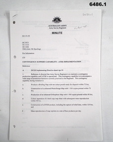
Document - Contingency Support Capability - Army Topographic Support Establishment (ATSE) Implementation, Army Survey Regiment, Bendigo, Apr - Jun 1995
... Army Svy Regt... RASvy Fortuna Army Survey Regiment Army Svy Regt ASR ATSE .1 ....1 The Minute details that the Army Survey Regiment is maintain a contingency production capability until ATSE is operational. .2 The Minute details the Data Aquisition Squadron requirements during the Implementation to ATSE. .3 The Minute details the Hardware, Software, Personnel and skills required during Implementation to ATSE. .4 The Instruction details that the non-core mapping, charting and geodetic (MC&G) activities of the Army Survey Regiment and 4 Fd Svy Sqn were tested under the Commercial Support Program (CSP) process resulting in the decision to award the contract for the provision of non-core mapping services to the ADF to the Preferred In-House Option (PIHO). .1 Contingency Support Capability - Army Topographic Support Establishment (ATSE) Implementation 26 Apr 95 (11 x A4 pages) .2 Data Acquisition Squadron (DAS) Contingency Support Capability - Army Topographic Support Establishment (ATSE) Implementation Apr 95 (4 x A4 Pages) .3 Contingency Support Capability - Army Topographic Support Establishment (ATSE) Implementation 28 Apr 95 (9 x A4 pages) .4 Directorate of Military Survey - Army Instruction for Implementation of the Army Topographic Support Establishment (ATSE) Jun 95 (10 x A4 pages)royal australian survey corps, rasvy, fortuna, army survey regiment, army svy regt, asr, atse -
 Bendigo Military Museum
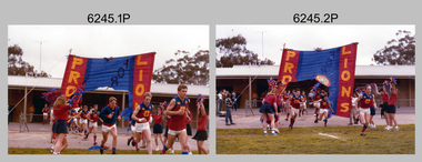
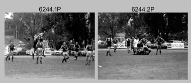
Photograph - Army Survey Regiment’s Fortuna Lions Football Club Grand Finals, Seymour, Victoria, 1983
... Army Svy Regt... Survey Corps RASvy Army Survey Regiment Army Svy Regt Fortuna asr ...This is a set of 25 colour photographs of Army Survey Regiment’s Australian Rules football team – the Fortuna Lions aka “Fortuna Fumblers”, taken at Seymour Victoria in 1983. The 26th item is a A4 paper document detailing the history of Fortuna Football Club from 1978 to 1993. The Fortuna Lions competed in the Puckapunyal Area Football Association for several years from 1978 to 1984 and in 1983, fielded a great team it managed to reach the Grand Final. Held at the neutral ground at Kings Park, Seymour, the match was an incredibly exciting and bruising contest played in damp conditions and ended in a draw. Dave Lawler’s spectacular mark was a highlight. Due to heavy rain during the following week, the Grand Final replay was held the following week in even heavier conditions. The Fortuna Lions prevailed in the replay with an emphatic victory. The team’s leaders were Eddie Jacobs (coach), Rhys De Laine (captain), Greg Else (vice-captain), and Ken Slater (manager). See items 6244.27P and 6274.7P for more photographs taken at the two grand finals. Although not part of the photo collection, the team photo with names .24P and a photo of the premiership banner .25P are included. The team changed its name to the Fortuna Falcons and its guernsey to gold with a blue ‘V’ in 1988 and continued to compete in the competition up to 1995.This is a set of 25 photographs of Army Survey Regiment’s Australian Rules football team – the Fortuna Lions aka “Fortuna Fumblers”, taken at Seymour Victoria in 1983. The 26th item is a A4 paper document detailing the history of Fortuna Football Club from 1978 to 1993. The photographs were printed on photographic paper They are part of the Army Survey Regiment’s Collection. The photographs were scanned at 300 dpi and the document at 200 dpi. Fortuna’s footballers named below are in Fitzroy jumpers. .1) - Photo, colour. 1983. L to R: Nick Van Dalen, Jim Ash, Dennis Learmonth, Greg Higgins, Dave Lawler. .2) - Photo, colour. 1983. L to R: Terry McIntyre, Andy Godden, Rod Skidmore, Alan Staley, Carmel Butler, Gayle Humphrey. .3) - Photo, colour. 1983. L to R: Greg Else, Doug Home, Wendy Leitinger, Leah Hoffman, Carmel Butler, Ken Talbot-Smith. .4) - Photo, colour. 1983. L to R: Leah Hoffman, Carmel Butler, Kristin Skidmore, Neville Carr, Brian Fauth on right of banner. .5) - Photo, colour. 1983. L to R: Dave Lawler, Larry Thompson, Rod Skidmore, Greg Higgins, Gayle Humphrey. .6) and .7) - Photo, colour. 1983. Army Survey Regiment, 1st Armoured Regiment and officials line up before game. .8) - Photo, colour. 1983. L to R: unidentified (x2), Kristin Skidmore, Carmel Fauth, Leah Hoffman, Wendy Leitinger, Gayle Humphrey, Di Weston, unidentified, Rob Straube. .9) and .10) - Photo, colour. 1983. Competition’s individual award recipients. Eddie Jacobs in white shorts. .11) and .12) - Photo, colour. 1983. Fortuna’s supporters on boundary. .13) to .15) - Photo, colour. 1983. All players unidentified. .16) - Photo, colour. 1983. Dave Lawler launches to take a spectacular mark. .17) - Photo, colour. 1983. L to R: Stu Ridge (No.2) Eddie Jacobs (No.16), and (No.9). .18) - Photo, colour. 1983. L to R: unidentified (No.9), unidentified, Alan Staley (No.7). .19) - Photo, colour. 1983. L to R: Alan Staley (No.7), unidentified (No.17), unidentified, unidentified (No.9), Greg Higgins (No.20). .20) - Photo, colour. 1983. All players unidentified. .21) - Photo, colour. 1983. Peter Jones (No.5) .22) - Photo, colour. 1983. L to R: Greg Higgins (No.20), unidentified, Alan Staley (No.7). .23) - Photo, colour. 1983. L to R: Unidentified, Greg Byers (No.19). .24) - Photo, colour. 1983. Fortuna Football Club Team Photo. .25) - Banner, colour. 1983. Fortuna Football Club Premiership Banner. .26) - Document, black & white. 1993. History of Fortuna Football Club from 1978 to 1993..1P to .23P – no annotations .24P – Members of team named on bottom .26 - A4 size paper document of the team’s history.royal australian survey corps, rasvy, army survey regiment, army svy regt, fortuna, asr -
 Bendigo Military Museum
Photograph - Army Survey Regiment’s Fortuna Lions Football Club Grand Finals, Seymour, Victoria, 1983
... Army Svy Regt... Survey Regiment Army Svy Regt Fortuna asr .1P to .27P ...This is a set of 27 black & white photographs of Army Survey Regiment’s Australian Rules football team – the Fortuna Lions aka “Fortuna Fumblers”, taken at Seymour Victoria in 1983. The Fortuna Lions competed in the Puckapunyal Area Football Association for several years from 1978 to 1984 and in 1983, fielded a great team it managed to reach the Grand Final. Held at the neutral ground at Kings Park, Seymour, the match was an incredibly exciting and bruising contest played in damp conditions and ended in a draw. Dave Lawler’s spectacular mark was a highlight. Due to heavy rain during the following week, the Grand Final replay was held the following week in even heavier conditions. The Fortuna Lions prevailed in the replay with an emphatic victory. The team’s leaders were Eddie Jacobs (coach), Rhys De Laine (captain), Greg Else (vice-captain), and Ken Slater (manager). See item 6274.7P for more photographs taken at the two grand finals, team photo. See item 6245.26P for colour photos of the finals, the team photo with names and a photo of the premiership banner. The team changed its name to the Fortuna Falcons and its guernsey to gold with a blue ‘V’ in 1988 and continued to compete in the competition up to 1995. This is a set of 27 black and white photographs of Army Survey Regiment’s Australian Rules football team – the Fortuna Lions aka “Fortuna Fumblers”, taken at Seymour Victoria in 1983. The photographs were printed on photographic paper and are part of the Army Survey Regiment’s Collection. The photographs were scanned at 300 dpi. Players named below are in Fitzroy jumpers. .1) - Photo, black and white. 1983. L to R: Mick Hogan, Peter Jones (ruck), Rod Skidmore (No.14), Greg Else, Stu Ridge (No.2). .2) - Photo, black and white. 1983. L to R: Rhys De Laine, Doug Home, Mick Hogan (no.12), Rod Skidmore. .3) - Photo, black and white. 1983. L to R: unidentified (x2), Keith Quinton, Doug Home, Mick Hogan. .4) - Photo, black and white. 1983. L to R: Rod Skidmore, Greg Byers, Rhys De Laine, Rhys De Laine, Jim Ash. .5) - Photo, black and white. 1983. L to R: Stu Ridge (No.2) Peter Jones (ruck No.5), Mick Hogan. .6) - Photo, black and white. 1983. L to R: Keith Quinton (No.3), unidentified (No.8), Dennis Learmonth, Greg Byers. .7) - Photo, black and white. 1983. L to R: Greg Byers, Greg Higgins, Stu Ridge, Dennis Learmonth (No.10), Keith Quinton. .8) - Photo, black and white. 1983. L to R: Bob Thrower (No.21), Peter Jones, Dennis Learmonth (No.10). .9) - Photo, black and white. 1983. L to R: all unidentified. .10) - Photo, black and white. 1983. L to R: Mick Hogan (no.12), Doug Home, Peter Jones (No.5), Greg Else, Jim Ash. .11) - Photo, black and white. 1983. L to R: Dennis Learmonth, Keith Quinton. .12) - Photo, black and white. 1983. L to R: unidentified, Eddie Jacobs (No.16), Greg Higgins (No.20). .13) - Photo, black and white. 1983. L to R: all unidentified. .14) - Photo, black and white. 1983. L to R: Rod Skidmore, Jim Ash. .15) - Photo, black and white. 1983. L to R: Greg Else (No.6), Mick Hogan (No.12), Alan Staley, unidentified. .16) - Photo, black and white. 1983. L to R: unidentified, Peter Jones, Rhys De Laine. .17) - Photo, black and white. 1983. L to R: Eddie Jacobs, Greg Else. .18) - Photo, black and white. 1983. L to R: Keith Quinton (No.3), Rod Skidmore, Eddie Jacobs, Dave Lawler. .19) - Photo, black and white. 1983. L to R: Doug Home, Greg Byers, Bob Thrower, Rod Skidmore, unidentified. .20) - Photo, black and white. 1983. L to R: Stu Ridge (No.2), Greg Higgins (No.20), unidentified (No.8). .21) - Photo, black and white. 1983. L to R: all unidentified. .22) - Photo, black and white. 1983. L to R: Peter Jones (no.5), Greg Byers (No.19), unidentified (x2). .23) - Photo, black and white. 1983. L to R: unidentified. .24) - Photo, black and white. 1983. L to R: Mick Hogan, unidentified (no.13), Rhys De Laine, Jim Ash, Keith Quinton (No.3). .25) - Photo, black and white. 1983. L to R: Steve Burke, Peter Dillon, Jim Ash, Dave Lawler, Paul Baker, Tracy Ash, unidentified, Warren Hall. In far-right background: Greg Else, Megan Reynolds. .26) - Photo, black and white. 1983. L to R: Warren Hall, Ken Slater, Cliff Webb, shirtless Glen Cannon. .27) - Photo, black and white. 1983. L to R: Warren Hall, unidentified..1P to .27P – no annotationsroyal australian survey corps, rasvy, army survey regiment, army svy regt, fortuna, asr -
 Bendigo Military Museum
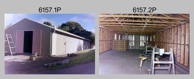
Photograph - Lithographic Squadron Building Upgrades - Army Survey Regiment, Fortuna, Bendigo, 1990
... Army Svy Regt... Army Survey Regiment Army Svy Regt Fortuna ASR litho ...This is a set of 11 photographs of Lithographic Squadron Building Upgrades at the Army Survey Regiment, Fortuna, Bendigo. 1990. These upgrades performed by Litho personnel occurred at around the same time as the construction of Lithographic Squadron’s new Printing Building. This is a set of 11 photograph of Lithographic Squadron building upgrades at the Army Survey Regiment at Fortuna, Bendigo, 1990. The photographs were on 35mm negative film and were scanned at 96 dpi. They are part of the Army Survey Regiment’s Collection. .1) and .2) - Photo, colour, 1990, building construction. .3) - Photo, colour, 1990, building modifications, L to R: Dale Hudson, WO2 Keith Fenton RE. .4) - Photo, colour, 1990, building modifications, L to R: Roy Hicks, Lance Strudwick, Dale Hudson, Ian Nicholls, Gary Lord, Kim Reynolds, Peter Swandale (rear), Gavin McLean, Andrew Arman, Graham Spong, Mark McCullough. .5) - Photo, colour, 1990. building modifications, L to R: Ross Anza, unidentified, Damien Cole. .6) and .7) - Photo, colour, 1990, Old proofing hut. .8) - Photo, colour, 1990, building modifications, Brian Fauth. .9) - Photo, colour, 1990, building modifications, L to R: Roy Hicks, Brian Fauth. .10) - Photo, colour, 1990, building modifications, L to R: Peter Swandale, Gary Kerr, Ian Nicholls, Brian Fauth, Roy Hicks. .11) - Photo, colour, 1990, building modifications, L to R: Peter Swandale, Gary Kerr, Brian Fauth, Ian Nicholls, Roy Hicks. No personnel are identified. royal australian survey corps, rasvy, army survey regiment, army svy regt, fortuna, asr, litho