Showing 9254 items
matching baily
-
 Linton and District Historical Society Inc
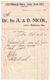
Receipt, Edinburgh Bakery, Sussex Street, Linton
Invoice and receipt from A. & D. Nicol for the purchase of a bay mare with black points.Text: " Edinburgh Bakery, Sussex Street, / Linton / Dr. to A. & D. Nicol, / Bakers. "edinburgh bakery, a. nicol, d. nicol -
 Lakes Entrance Historical Society
Book, Parks Victoria Compiler, MacLeod Morass & Jones Bay Draft Management Plan 2003, 2003
A draft plan for the startegies to manage the Macleod Morass and Jones Bay Wildlife reservesenvironment, fauna, natural resources, restoration, vegetation -
 Port Melbourne Historical & Preservation Society
Photograph - Properties in Bay Street, Port Melbourne
Photographic images of properties in Port Melbourne. Image may have been taken by a PMHPS member or scanned from a past resident or taken for real estate sale purposes. .01 - 382 Bay St (March 2007) .02 & .03 - Starbucks Coffee Corner Bay & Graham Streets (January 2006) .04 - Holy Trinity residential redevelopment (January 2006) .05 - Bay St verandah detail (March 2007) .06 - Residential redevelopment on Northern corner Bay and Graham Streets (September 2010)built environment - domestic, built environment - commercial, bay street, starbucks, holy trinity -
Port Melbourne Historical & Preservation Society
Photograph - Original Post Office/Mail exchange, Bay Street, Port Melbourne, David Thompson, c. 1998
Seven colour photographs of the original Post Office/Mail Exchange Bay Street c 1998: details of brick work, faded sign and post pillar which standsoutside on the corner of Bay and Rouse (was removed but now restored)built environment - civic -
Port Melbourne Historical & Preservation Society
Card - Binder, Piers Festival, Polly Woodside Maritime Museum, c. 1990
These migrant ship cards were used loose by the former Maritime Museum (Polly Woodside), and donated to PMHPS by A Gibson, National Trust Victoria, bound in January 2013 for use in the PMHPS display on migrant ships in Princes Pier GatehouseOne of three sets of laminated information cards, punched and roughly bound into a book for information display at "Piers festival". (.01) - "Angelina Lauro" to "Esperance Bay" (.02) - "Fairsea" to "Moreton Bay" (.03) - "Northern Star" to "Stathmore"The backs of the cards are pasted with sections of nautical maps.transport - shipping, immigration, celebrations fetes and exhibitions, angelina lauro, arcadia, australis, canberra, captain cook, captain hobson, castel felice, chusan, dominion monarch, ellinis, esperance bay, fairsea, fairstar, fairsky, galileo galilei, himilaya, johan van olden barnevelt, largs bay, maasdam, mariposa, moreton bay, northern star, orion, oriana, oronsay, ormonde, orsova, otranto, patris, roma, southern cross, stathaird, statheden, stathmore, ss iberia, ss guglielmo marconi -
 Mont De Lancey
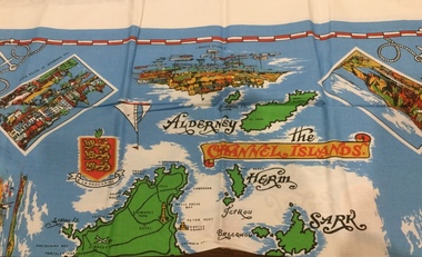
Functional object - Tablecloth
A square, souvenir tablecloth from the Channel Islands. On an azure background, all the islands are printed and named on the tablecloth, as well as the names of the towns, villages and the bays of both Jersey and Guernsey. There are four rectangular pictures, surrounded by a white border, representing significant places and buildings, as well as others, without borders, depicting old and modern ships, a compass, a coat of arms and the distinctive Jersey and Guernsey cow.There is a red and white border, almost at the edge of the azure background and in each corner is printed a white anchor and rope. There is also a 3 cm. plain white outer border around the tablecloth.Names of places, beaches and bays on the Channel islands. Pictorial representations of significant places and buildings and a white anchor and rope in each of the four corners. "Exclusive to Creaseys of Guernsey" is printed at the bottom left hand corner of the tablecloth.table ware., household textiles., table linen. -
Glenelg Shire Council Cultural Collection
Programme - Programme of events for the Portland Centenary celebrations 1934, c. 1934
Portland Centenary celebrations 1934Single fold DL flyer, programme of events for the Portland Centenary celebrations 13 - 20 NOV 1934. White paper, black print. Photo of Edward Henty and Portland Bay on front, warships in Portland Bay at sunrise, on back.portland centenary celebrations 1934 -
Port Melbourne Historical & Preservation Society
Photograph - Double-sided aerial photograph, Hobson's Bay and the Yarra River/Port Phillip and Western Port Bay, Surveyor General and Director of Mapping, Apr 1990
Landsat imagery - an extract from the atlas of VictoriaAerial photos of Port Phillip and Western Port (double sided aerial photographs). 1995 side A: Hobson's Bay and Yarra River - aerial photo mosaic; side B. Port Phillip and Western Port Bays - satellite photo.port of melbourne authority -
Port Melbourne Historical & Preservation Society
Document - MMBW re proposed canopy, Bay Garage, Bay Street, Port Melbourne, The Shell Company of Australia Limited, 1964 - 1965
Melbourne and Metropolitan Board of Works (MMBW) documents referring to the Bay Garage, Bay St, Port Melbourne and a proposed new canopy. .01- letter dated 25 March 1965 .02 - plans dated 6 November 1964built environment - commercial, transport - motor vehicles, mmbw, the shell company of australia ltd, melbourne and metropolitan board of works -
Port Melbourne Historical & Preservation Society
Book, Making the Most of the Bay, Apr 1989
'Making the Most of the Bay'- a draft plan for the protection and development of Port Phillip and Corio Bays, 1989. A draft plan to guide decision making. Introduction by Tom Roper, Minister for Planning and Development. (Refer item 1048, final version)state government victoria, natural environment, town planning -
 Flagstaff Hill Maritime Museum and Village
Document - Navigation Chart, Admiralty Office, Lady Bay and Warrnambool Harbour, 1893
This navigation cart of Lady Bay and Warrnambool Harbour was originally surveyed in 1870 but this version includes the update for magnetic variation in 1893. Since the printing of the chart several annotations have been added. These include an additional stamp dated 15-8-1910, a handwritten comment across the top of the page dated August 1910, and another handwritten comment regarding the ‘Proposed Extension of Dock’ dated 19-2-1925, plus connected drawings, notes and figures. The 1925 proposal on this chart may have been a reaction to the Royal Commission of 1923, when the damaged stonework on the seaward side of the Warrnambool Breakwater, caused by the action of the sea, was the subject of enquiry. A conference between the Public Works, Water Commission and the Harbour Trust concluded that it would less costly to make repairs to prevent further damage rather than replaced the damage portion of the wall. A contract was raised in late 1924 to deposit rubble on the damaged side of the breakwater to minimise the Southern Ocean’s destructive action and work had started by August 1925. The Breakwater construction had begun in 1874 and was completed in 1890. The Victorian Government had commissioned Sir John Coode, a British harbour engineer, to present a plan to complete the Warrnambool Breakwater but his original plan was too expensive. He prepared a revised plan for a shorter structure. The construction proved to be too short to protect adequately from the weather and didn't allow enough depth for larger vessels to come into port. The decreasing trade was further affected by siltation in the bay due to the breakwater, and the completion of the railway line. The situation of the harbour became a real problem by 1910 and required continuous dredging. In 1914 the Breakwater was extended but proved to be a failure because the work began to subside and by 1920 about two thirds of the harbour was silted up. Alterations made in the 1920's increased the silting problem and by the 1940's the harbour was no longer used. More alterations were made in the 1950's and 1960's. This chart is significant for its strong connection to the maritime history of Warrnambool Harbour and Lady Bay and the Warrnambool Breakwater. The Warrnambool Breakwater is registered as a place of significance on the Victorian Heritage Database (VHR H2024). The Warrnambool Breakwater is one of the most important late 19th century maritime engineering projects in Victoria and significant in the development of Victorian coastal shipping. It is also significant for its connection with British harbour engineer, Sir John Coode. The chart is a historical record of structures existing in 1893; the Warrnambool Jetties, Warrnambool Breakwater in Lady Bay, the leading lights (lighthouses), streets, roads, bridges and many buildings. It also shows the lay of the land and seabed. Navigation Chart: Lady Bay and Warrnambool Harbour, Australia - South Coast - Victoria. Surveyed by Nav. Lieut. H.J. Stanley, R.N., 1870. Updated for Magnetic Variation, 1893. The rectangular chart is printed on heavy cream paper. Stamps are shaped rectangular, oval and round. Around the Breakwater and Jetty area are handwritten notes, dotted and joined lines, numbers and signatures, and shading of red and green. The chart shows the surrounds of Warrnambool Harbour, Lady Bay, the Breakwater and Jetty, roads, bridges and the streets in Warrnambool. It has sounding details, and angles of line from the leading lights.Stamp, rectangular, including "AUG 1910" Stamp, double oval " - - - -CHART" Stamp, hand drawn, red circle, with "B" inside Hand written note "22-8-1910 - - - - - of surveying C. Ca - - - request of 15-8-10 [initials] " Notes and lines in red pen, including a grid of sounding numbers: "1300" "1050" "1200" "Possible Extension of Dock" "19-2-25" "Dock Dredged to 20 Ft" Notes and lines in blue pen "Extension of Dock to accommodate vessels drawing 20 Feet" and "Light not visible south of this line" Red dots (4) with yellow highlight at both leading lights, breakwater and jettyflagstaff hill, warrnambool, flagstaff hill maritime museum & village, maritime museum, maritime village, shipwreck coast, map, chart, navigation chart, plan, lady bay, warrnambool harbour, port of warrnambool, breakwater, jetty, pier, dock extension, proposed extension, vhr h2024, 1870, 1893, 1910, 1925, warrnambool town late 1800s, warrnambool streets late 1800s royal commission, 1923, public works, water commission, harbour trust, victorian harbours, sir jon coode -
 Phillip Island and District Historical Society Inc.
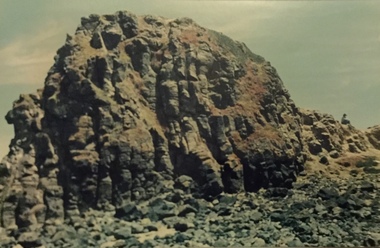
Photograph, Kitty Miller Bay and the wreck of the Speke, 1990s
Photos were mainly taken by Bernard Grayden who resided on Phillip Island as a child and later in retirement. Coloured photographs of the remains of the wreck of the Speke and the Knoll at Kitty Miller Bay, Phillip Island.the speke, kitty miller bay phillip island, shipwrecks, photographs -
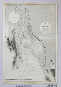 Flagstaff Hill Maritime Museum and Village
Document - Navigation Chart, Tavoy River
British Admiralty Navigation Chart - Bay of Bexgal - East Coast - Bruma - Tavoy Riverwarrnambool, shipwrecked-coast, flagstaff-hill, flagstaff-hill-maritime-museum, maritime-museum, shipwreck-coast, flagstaff-hill-maritime-village, shipwrecked-artefact, navigation chart, british admiralty navigation chart, british admiralty, tavoy river, bay of bexgal, bruma -
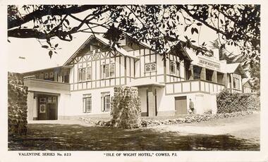 Phillip Island and District Historical Society Inc.
Photograph - Post Card
One of a collection of photographs donated by Mrs W. Rankine.Black & white Postcard of the Isle of Wight Hotel with Morton Bay Fig Tree in foreground.Valentine Series No 823 "Isle of Wight Hotel," Cowes, P.I.phillip island, cowes, isle of wight hotel -
Glenelg Shire Council Cultural Collection
Photograph - Photograph - Bridgewater Bay, Bridgewater Victoria, n.d
Black and white photo. View from beach across bay, Cape Bridgewater in distance.Back: 'Cape Bridgewater in distance. View of beach' - handwritten, black ink Round purple stamp 'PRINTED BY M.E. ANDREWS PORTLAND'bridgewater bay -
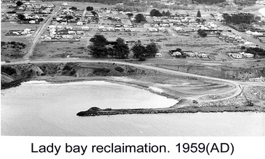
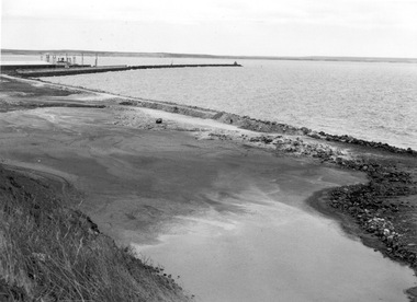 Glenelg Shire Council Cultural Collection
Photograph - Photograph - Lady Bay Reclamation, c. 1960
Port of Portland Authority archivesFront: (no inscriptions) Back: (no inscriptions)port of portland archives, lady bay, reclamation, 1960s -
 Glenelg Shire Council Cultural Collection
Photograph - Photograph - Lady Bay Reclamation, c. 1960
Port of Portland Authority archivesFront: (no inscriptions) Back: (no inscriptions)port of portland archives, lady bay, reclamation, 1960s -
 Glenelg Shire Council Cultural Collection
Photograph - Photograph - Lady Bay reclamation, c. 1960
Port of Portland Authority archivesFront: (no inscriptions) Back: (no inscriptions)port of portland archives, lady bay, reclamation -
Glenelg Shire Council Cultural Collection
Photograph, n.d
Port of Portland Authority ArchivesBack: Dutton Way - 3 - pencil 70/6 - blur biroport of portland authority archives, dutton way, portland bay -
 Bendigo Historical Society Inc.
Photograph - LUKE'S BAKERY - GOLDEN SQUARE
Black and white photograph of Luke's bakery corner Bay and High Streets, Golden Squarebendigo, buildings, luke' s bakery -
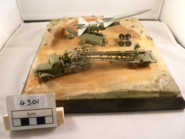 National Vietnam Veterans Museum (NVVM)
Model - Diorama, Guided Missile System
A diorama of a Guided Missile system located in a prepared firing bay with launch vehicle and crew.diorama, guided missile -
Port Melbourne Historical & Preservation Society
Tool - Pen, Ballpoint, City of Port Melbourne and Borough by the Bay, 1980s - 1990s
Given together with 972.02 and a lemon-scented gum seedling to Pat Grainger when she was naturalised at the Port Town Hall in 1992Red and blue plastic ballpoint pens stamped with the City of Port Melbourne and 'Borough by the Bay'immigration -
Port Melbourne Historical & Preservation Society
Photograph - Unidentified group outside Chequers Inn Hotel, corner Bay and Bridge Streets, Port Melbourne, 1940s
Unknown group photo outside Chequers Inn Hotel corner Bay and Bridge StsBridge and Chequers on backbuilt environment - commercial, nancy lewis, chequers inn -
Port Melbourne Historical & Preservation Society
Document - Proposal, Future directions and vision statement of Bay Street, Jan 1999
Book of future directions and vision statement of Bay Street. Jan 1999. A3 bound.local government - city of port phillip, bay street committeee of management inc -
Port Melbourne Historical & Preservation Society
Photograph - Restored cars with Port Melbourne Town Hall and Bay Street, 1950s
Photocopy of page of restored cars with photo of Town Hall and Bay Street, early 1950stransport - motor vehicles, port melbourne town hall, gray's, renfrey's toy shop, business and traders -
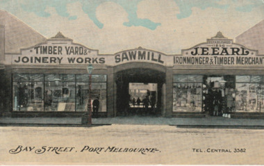 Port Melbourne Historical & Preservation Society
Postcard - J E Earl, Bay Street, Port Melbourne, 1910s
Postcard owned by Beatrice (Betty) Goddard, who worked in the J.E. Earl office from February 1956 to May 1979, donated to SocietyJ.E.Earl promotional postcard showing the earliest Bay Street building and timber yard 1910s business and traders - timber, j e earl pty ltd, beatrice (betty) goddard -
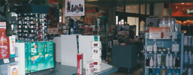 Port Melbourne Historical & Preservation Society
Photograph - Interior, picture framers and art shop, Bay Street, Port Melbourne, 2000
(1) colour photograph showing the interior of the picture framers and art shop in Bay Stbusiness and traders -
Port Melbourne Historical & Preservation Society
Photograph - Port Melbourne foreshore from the Bay, David Thompson, 8 Mar 1993
Colour photo of Port Melbourne foreshore prior to demolitions, shot from the Bay 8.3.1993Details on back in inkbuilt environment -
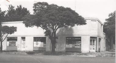
Port Melbourne Historical & Preservation Society
Photograph - Redevelopment SW corner Bay and Liardet Streets, c. 1988
B&W photocopy of the redevelopment of south west corner of Bay Street and Liardet Streettown planning, liardet street, bay street -
Port Melbourne Historical & Preservation Society
Photograph - View over Bay Street and rooftops towards City of Melbourne, Jack GOULD, 1975
From a box of photographs in Nancy U'REN's papers used during research for her thesis, The Early Growth and Development of Sandridge (1976) and/or her book with Noel TURNBULL, A History of Port Melbourne (1983). Black and white photograph looking toward the city from a rooftop in Bay Street in 1975.bay street, port melbourne town hall, nancy u'ren nee morris