Showing 391 items
matching bridges -- river yarra
-
 Kew Historical Society Inc
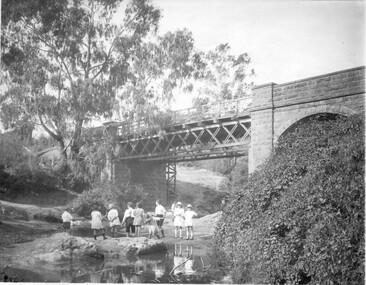
Postcard, R McGeehan, The Effect of Storm. Train Passing Through Flood Waters, South Yarra, 25-1-07, 1907
SHARP DOWNPOUR. ONE INCH IN 45 MINUTES. SOUTHERN SUBURBS DELUGED. TRAIN STOPPED AT SOUTH YARRA. One of the sudden downpours of rain which occasionally fall in Melbourne occurred yesterday afternoon, when nearly an inch of rain fell in the course of three quarters of an hour, and caused a flood for an hour or two in certain localities. During the early part of the day, the sky had been clouded over, but there was nothing to indicate a storm of such intensity as that which followed. At about half-past 1 o'clock residents of South Yarra, South Melbourne, Prahran, and St. Kilda noticed a few drops of rain. Still, it appeared unlikely that there would be anything exceptional, until with startling suddenness at about 10 minutes to 1 o'clock, one of the heaviest downpours within the memory of residents burst upon those suburbs. A strange feature of the storm was that it was practically confined to an area of about three miles square. The city was but little affected, though at a spot as close as the Observatory 86 points of rain were recorded in three-quarters of an hour. Thunder and lightning accompanied the downpour, which was cyclonic in character, the rain driving heavily from all points of the compass as the cyclone passed. It was in South Yarra and Prahran that the rain fell heaviest. Within a few minutes after it commenced, the low-lying portions of Toorak-road and practically the whole length of Chapel-street were under water. The depression at the intersection of Toorak-road and Darling-street speedily filled to the dimensions of a small lake. Several shops were inundated, while the water from the higher levels rushed down like a mountain torrent, and in several in-stances swept through the rear of houses and shops, carrying furniture in a floating mass against the further walls. In one case a footbridge was carried bodily away and dashed to pieces. Darling-street itself Great Davis-street, and other low-lying and flat thoroughfares in the vicinity became flooded from kerb to kerb, while on the other side of the railway-bridge the valley between Kensington-road and River-street became filled for some minutes to a depth of several feet. Meanwhile the waters from South Yarra hill, seeking a lower level, found it in the railway cutting, and the excavations from South Yarra station to Prahran on the one line, and to the Chapel-street bridge on the other, were converted into a couple of canals. At the platforms at South Yarra the water was two feet deep on the permanent way, and towards Hawksburn, at the sudden depression under Chapel-street bridge, it was at one time deep enough to cover a tall man's head. Into this swirling mass of water the 1:50 p.m. train from Oakleigh plunged on its way to Melbourne. The impact caused a mighty fountain of water to rise to a height of about 20 feet above the level of Chapel-street and send clouds of spray in all directions. Under the belief that a terrible explosion had occurred residents braved the rain and rushed to the spot, only to find that the train had been brought to a stand-still in the middle of what seemed to be a river. The water was so high that it had entered the fire-box from below, extinguishing the fires and cutting off the steam supply. In the meantime the officials at the South Yarra station had been preparing for emergencies. Inspectors were on duty at intervals along the line, and the moment the alarm was given an extra engine was backed carefully down and continued on to connect with the stranded train without losing its own power. There was a delay of about ten minutes in the service for an hour or two, but by 5 o'clock all the trains were running on time again, and the water had run off all but the spot beneath the Chapel-street bridge. Here the water remained about four feet deep until nightfall, and throughout the afternoon several hundreds of people including biograph operators and photographers, were gathered around watching each train pass through. Even with the water two feet lower, this was a work attended with considerable difficulty. Each train had to absolutely force its way through the weight of water, almost enveloped by the spray thrown up, and it was only just able to negotiate the "ford" by using every ounce of steam. ... The Argus, 26 January 1907, p19.The item forms part of the Laurie Bennett collection of thirty-six postcards and photographs of Kew and early Melbourne, donated to the Kew Historical Society in 1980. The postcards in the Bennett collection, like other images in the Society's holdings date from the 1890s to the present and comprehensively indicate points-of-view or scenes considered historically, aesthetically or socially significant in the period in which they were produced.Postcard depicting a flood at South Yarra Station in 1907. The title and photographer's name are identified on the front of the postcard. Donated by L. Bennett, 1980flood - south yarra, trains - melbourne, postcards, r mcgeehan - prahran -
 Kew Historical Society Inc
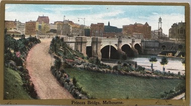
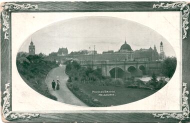
Postcard, Princess Bridge, Melbourne, c.1907
... -east bank of the Yarra River, looking towards the city ...The Kew Historical Society's postcard collection includes views of Kew, Melbourne and Greater Melbourne as well as those including overseas scenes sent or received from Europe or the Middle East. They date from the 1890s to the 2000s. These postcards may or may not include the name of the publisher or printer. A number of the cards were published as parts of popular series. A way of dating early postcards is to identify whether the reverse was divided by a central line which became the norm after 1902 in the United Kingdom. However, other postcards produced after this date do not always conform to this print layout.Rare variant version of this view of Princes Bridge, from the south-east bank of the Yarra River, looking towards the city of Melbourne, showing landmarks of the period.Polychrome postcard of Princess Bridge in Melbourne.Princess Bridge, Melbourne Miss McGilivray, "Oak Bank", Peterborough, _____. princess bridge -- melbourne (vic.), river yarra, postcards -- melbourne (vic.) -
 Kew Historical Society Inc
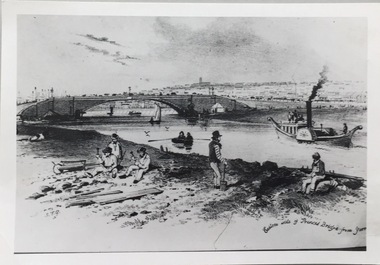
Photograph - Photograph (copy), S T Gill, Eastern side of Princess Bridge From Yarra, 1860-1880 (original)
... princess bridge -- river Yarra - melbourne (vic.)... the Yarra River at Princess Bridge, Melbourne.... reproductions -- s t gill princess bridge -- river Yarra - melbourne ...Copy of a painting (or etching) by S.T. Gill showing the Yarra River at Princess Bridge, Melbourne.Inscription reverse: "Eastern side of old Princess Bridge from Yarra"reproductions -- s t gill, princess bridge -- river yarra - melbourne (vic.) -
 Kew Historical Society Inc
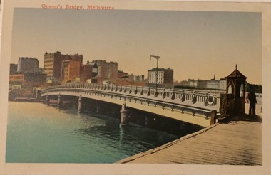
Postcard, Queen's Bridge, Melbourne, c.1920
... queens bridge - melbourne , yarra river - melbourne... - melbourne , yarra river - melbourne Weir Collection postcards ...Collection of thirty-nine postcards donated by Jillian Rigby which had been owned by her grandparents, George and Edith Weir, who from c.1917 lived at 84 Princess Street, Kew. The mostly 'mint' postcards were purchased in Victoria and while travelling overseas. The sole dated postcard is dated from 1929. The postcards are numbered sequentially from 2017.0058.01-39. The remainder of the collection donated by Jill Rigby which was once owned by the Weirs of Broken Hill and Kew consist of costumes, costume accessories, photographs, and documents.The postcards in the Weir collection, especially those purchased on a trip or trips to the mother country, i.e. United Kingdom, represent a representative sample of sites that were considered significant to those Australians undertaking a reverse grand tour by member of the erstwhile colonies. Those postcards which are early views of Melbourne must have been produced commercially for some decades from the early part of the 20th century.Queen's Bridge, Melbourne. Coloured postcard. Weir collection."Queen's Bridge, Melbourne"postcards, george and edith weir, queens bridge - melbourne , yarra river - melbourne, weir collection, postcards -- melbourne (vic.) -
 Kew Historical Society Inc
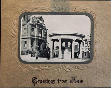
Postcard, Greetings from Kew, c.1928
... Park Road, River Yarra showing new Bridge [Chandler Hwy], High...: Studley Park Road, River Yarra showing new Bridge [Chandler Hwy ...An item from an outstanding and diverse photographic collection, assembled by members of the Christian and Washfold families of Kew.Rae series of postcards, otherwise unknown, showing important sites in KewSmall folding postcard including nine black and white postcard views of Kew. Cover depicts Kew War Memorial set within an embossed cardboard frame. Individual postcards include: Studley Park Road, River Yarra showing new Bridge [Chandler Hwy], High Street showing soldier's memorial, River Yarra at Victoria Bridge, The Yarra at Studley Park, Holy Trinity Church, the [Alexandra] Gardens, New Yarra Bridge [Burke Rd], Soldiers' Memorial and Post Office Kewwashfold family, christian-washfold collection, postcards -- kew (vic.) -
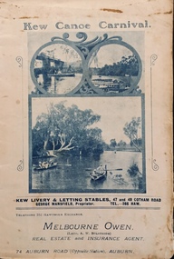 Kew Historical Society Inc
Programme, Kew Canoe Carnival, 1910
An item from an outstanding and diverse photographic collection, assembled by members of the Christian and Washfold families of Kew.Rare programme for what was once an annual event in Kew with important, possibly unique photos of sites in Kew and on the Yarra.Programme for the 1910 Kew Canoe Carnival which was held on the River Yarra on February 11th. The location was at the Asylum Reserve at the old white bridge (the precursor of Kane's Bridge). Funds were raised in Aid of the Annual Treat to Kew and Yarra Bend Patients (and the Carnival fund). The booklet includes details of the programme, numerous advertisements and rare and important historic photographs of the district including: the Willsmere Park Dairy, the Glen Tea Gardens at Hawthorn, the Pipe Bridge, the Kew Boat Sheds (Macauley's), and Rudder Grange boat house.christian-washfold collection, kew canoe club, kew canoe carnivals -
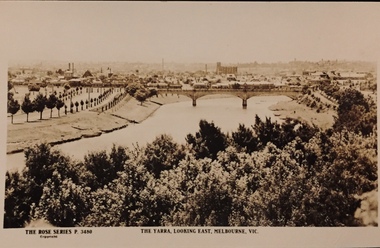 Kew Historical Society Inc
Postcard, Rose Stereograph Company, The Yarra Looking East, Melbourne, Vic
One of a number of 'real photo' and commercial postcards created by or owned by members of the Christian and Washfold families of Kew. The postcards are part of a larger collection of photographs, postcards and publications donated to the collection in May 2021.View of Melbourne on the horizon, looking in an easterly direction along the River Yarra. A State Library of Victoria catalogue record says ‘Elevated view along Yarra River, trees in foreground, line of saplings along both banks of the river, bridge in background (possibly Johnson Street Bridge)’. This may be incorrect.The Rose Series P. 3480yarra river -- melbourne, postcards -- yarra river, the rose series postcards, christian-washfold collection -
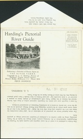 Kew Historical Society Inc
Postcard, Melbourne Ferries Pty Ltd, Harding's Pictorial River Guide
One of a number of 'real photo' and commercial postcards created by or owned by members of the Christian and Washfold families of Kew. The postcards are part of a larger collection of photographs, postcards and publications donated to the collection in May 2021.Postcard folder. Selection of ‘beauty spots’ along Yarra between Princes Bridge and Heidelberg via Studley Park. Boat advertises Harding’s Launches Studley Park & Heidelberg. Pictured boat is ‘25 Canberra’.harding's river cruises, river yarra -- tourism, harding's boat cruises, christian-washfold collection -
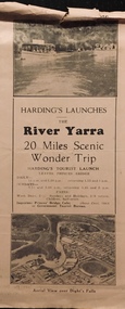 Kew Historical Society Inc
Flyer, Melbourne Ferries Pty Ltd, River Yarra: 20 Miles Scenic Wonder Trip
Bifold brochure including route map of the full 44 mile 'Wonder Trip' on pages 2 & 3. Photos used include an 'Aerial view over Dight's Falls', two ferries, and a 'Scene near Dight's Falls'.Flyer for Harding’s Launches on the River Yarra: 20 miles scenic wonder trip. Aerial view over Dight’s Falls on front. non-fictionBifold brochure including route map of the full 44 mile 'Wonder Trip' on pages 2 & 3. Photos used include an 'Aerial view over Dight's Falls', two ferries, and a 'Scene near Dight's Falls'.river yarra, melbourne ferries pty ltd, yarra river -- tourism, harding's cruises, christian-washfold collection -
 Kew Historical Society Inc
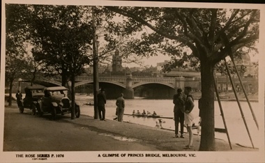
Postcard, Rose Stereograph Company, A Glimpse of Princes Bridge, Melbourne
One of a number of 'real photo' and commercial postcards created by or owned by members of the Christian and Washfold families of Kew. The postcards are part of a larger collection of photographs, postcards and publications donated to the collection in May 2021.Monochrome postcard of Yarra at Princes Bridge with rowers on river and cars, bystanders and an athlete in foreground. Three oars lean against tree. The Rose Series P. 1076postcards -- melbourne, princes bridge -- melbourne, postcards - the rose series, christian-washfold collection -
 Kew Historical Society Inc
Album - Photograph Album No.1, Henry Beater Christian, 1924-26
Henry Christian (c.1809-91), the grandfather of the photographer, was one of the first settlers in Kew. He arrived in Victoria with his wife Agnes and son Orlando in 1855 on the Gypsy Queen. He established a rope-making business in Bulleen Road by 1858 but was declared insolvent two years later. In his final years, he was celebrated as one of the oldest living settlers of the district. His son, Orlando Henry Beater Christian (c.1853-1930) became a member of the Hawthorn Band and a foundation member of the Willsmere Swimming Club. Orlando and his wife Elizabeth had four children of which Henry Beater Christian (1886-1962) was the oldest.An album of photographs, compiled by Henry Beater Christian (1886-1962) of Pakington Street, Kew, depicting individuals, natural and settled environments and the interactions between these worlds. Henry Christian, was a keen explorer, not just of his immediate environment but also of the Victorian wilderness. His major opus is contained in two albums in which he records, sometimes in majestic detail and on other occasions the intimate features of the natural world. His photographic travels during the 1920s, often in solitary ramblings but on other occasions with companions, recall the heroic landscape photography of an earlier era, pioneered by Nicholas Caire. In addition to their aesthetic value, the albums are historically significant records within the State of Victoria, of what is now a distant point in time, and of places that have become radically altered through human intervention.Digital copy of a 47-page photograph album containing 255 gelatinous silver images, loaned by Diane Washfold with permission given to digitise and hold a copy in our collection. The album contains a groups of photographic positives taken by Henry B Christian (a resident of Pakington Street), of places in Kew and throughout regional Victoria during the 1920s. The mainly sepia photographs, while small, are of a high resolution. Photographs are typically lightly glued onto pages. Locations are frequently identified by white or black ink, which in a number of cases is illegible due to wear.henry beater christian (1886-1962), landscape photography, photograph albums, kew (vic.) — yarra river, kew (vic.) — zig-zag bridge, kew (vic.) — macauley’s boathouse, studley park (vic.) — yarra river, wonderland — grampians (vic.), black spur (vic.), marysville (vic.), maroondah dam (vic.) — construction, warburton (vic.), cockatoo (vic.), bruthen (vic.), swan reach road (vic.), glen hills (vic.), lightning creek (vic.), omeo (vic.), glen wills (vic.), mt wills (vic.), sunnyside (vic), granite flat (vic.), toolangi (vic.), yea (vic, )., flowerdale (vic.), mt white law (vic.), baw baw (vic.), christian-washfold collection -
 Kew Historical Society Inc
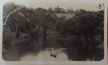
Photograph - Zig-zag Bridge on the Yarra River at Kew, Henry Beater Christian, 1920-28
... Zig-zag Bridge on the Yarra River at Kew... Bridge on the Yarra River at Kew Henry Beater Christian ...Henry Christian (c.1809-91), the grandfather of the photographer, was one of the first settlers in Kew. He arrived in Victoria with his wife Agnes and son Orlando in 1855 on the Gypsy Queen. He established a rope-making business in Bulleen Road by 1858 but was declared insolvent two years later. In his final years, he was celebrated as one of the oldest living settlers of the district. His son, Orlando Henry Beater Christian (c.1853-1930) became a member of the Hawthorn Band and a foundation member of the Willsmere Swimming Club. Orlando and his wife Elizabeth had four children of which Henry Beater Christian (1886-1962) was the eldest.Small black and white photograph of the Yarra River at Studley Park. In the middle ground, a man is paddling a canoe upstream. On the horizon, the tower and buildings of Raheen in Studley Park Road can be seen.henry christian (1886-1962), landscape photography, kew canoe club history — — photographs, yarra river -- studley park -- kew (vic.), christian-washfold collection -
 Kew Historical Society Inc
Photograph - Burgess House, Victoria Street (Abbotsford), 1880-1900
Major floods recurred of the Yarra River on a regular basis. A flood in 1901 destroyed this house in Victoria Street, Abbotsford. Later print copy of an original photograph. Home of C/N Burgess on the south side of Yarra River. The buildings were washed away in a flood in 1901 The house was in the same location as that on which Handley & Tilly was later built. This would locate it on the north side of Victoria Street, Abbotsford between Burnley Street and the Victoria Street Bridge. Photo shows three men and one woman working in an established garden in front of a weatherboard cottage."Home of C/N Burgess on south side of river; washed away in 1901; Handley & Tilly on site"yarra river -- floods, yarra river flood -- 1901, burgess family -- victoria street -- abbotsford (vic.) -
 Kew Historical Society Inc
Photograph - Yarra Flats near Burke Road Bridge, 1937
Land along the Yarra River in Kew is now either designated open space, parkland or public golf links. By the 1930s much of this area remained open farmland, bought at auction for dairy farming in the 1840s.Original, black and white positive print of what is said to be the Yarra Flats near Burke Road Bridge. On the horizon, building can be seen, whereas in the middle ground, farm fencing and a windmill are the main features as well as remnant Eucalypts. Inscribed verso: "Yarra Flats near Burke Rd Bridge 1937" studley park -- kew (vic.) -
 Kew Historical Society Inc
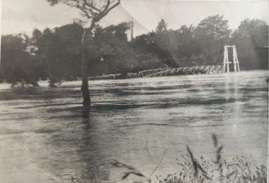
Photograph - Kane's Bridge on the Yarra River, December 1934
... Kane's Bridge on the Yarra River... the bridge's destruction. Photograph Kane's Bridge on the Yarra River ...In 1928 a footbridge was erected to link Kew with the public golf course across the Yarra. The total cost of construction came to 250 pounds and the bridge became known as Kane's Bridge. During the 1934 floods the bridge was washed downstream, and was subsequently rebuilt. The present form of the bridge resembles the earlier bridge which crossed from the Yarra Bend Asylum to Kew, further upstream. (VHD)Original, black and white positive of Kane's Bridge in December 1934, when the 'great flood' of the Yarra caused the bridge's destruction. Inscribed verso: "Kane's Bridge Yarra in flood Dec 1934"river yarra, yarra -- kew (vic.), kanes bridge, 1934 floods -
 Kew Historical Society Inc
Photograph - Kane's Bridge destroyed by the 1934 Flood, 1934
... , further upstream. (VHD) kane's bridge River Yarra Yarra valley ...In 1928 a footbridge was erected to link Kew with the public golf course across the Yarra. The total cost of construction came to 250 pounds and the bridge became known as Kane's Bridge. During the 1934 floods the bridge was washed downstream, and was subsequently rebuilt. The present form of the bridge resembles the earlier bridge which crossed from the Yarra Bend Asylum to Kew, further upstream. (VHD)Black and white positive print (identical to 2021.70 but with a different annotation) showing the destruction of Kane's Bridge in the floods of 1934. The Kodak paper would indicate a 1950s reprinting.Annotation verso: "Kane's Bridge in 1934 flood / Dec. 1934.kane's bridge, river yarra, yarra valley, 1934 floods -
 Kew Historical Society Inc
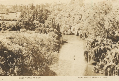
Photograph, River Yarra at Kew, c.1927
The River Yarra was a popular subject for photographic postcards. The postcards provide an interesting perspective of plantings on the banks of the Yarra at various periods. Small, sepia coloured real photo postcard of the River Yarra at Kew. The bird's eye view, presumably taken from Victoria Street Bridge shows the banks of the Yarra in the foreground densely planted with weeping willows. There is also canoe in the foreground. The expanse of lawn in the middle ground is that of 'Swinton', the tower of which can faintly be seen at the top centre of the view. "RIVER YARRA AT KEW / REAL PHOTO SERIES M. 2908 "real photo postcards, yarra river -- kew (vic.), postcards -- 1920s -
 The Dunmoochin Foundation
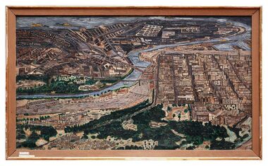
Oil Painting, Melbourne 1962, 1962
Thick impasto painting depicting a bird's eye view of the city of Melbourne and the Yarra river.Signed and dated 'Eric Stewart 1962'. eric stewart, painting, landscape, melbourne, yarra river -
 Mrs Aeneas Gunn Memorial Library
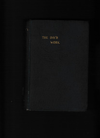
Book, Rudyard Kipling, The day's work, 1899
A collection of twelve stories ranging from the tale of a British engineer obsessed with saving his bridge from destruction by the flooding River Ganges, to the tale of an inconspicuous boat which mysteriously disappears on the high seas.p.406.fictionA collection of twelve stories ranging from the tale of a British engineer obsessed with saving his bridge from destruction by the flooding River Ganges, to the tale of an inconspicuous boat which mysteriously disappears on the high seas. england - fiction, england - short stories -
 Canterbury History Group
Book, Richard Broome, Remembering Melbourne 1850-1960, 2016
A book of over 700 black and white illustrations and photographs of early Melbourne scenes, mainly buildings, which have been demolished or significantly changed. The first half of the book concentrates on the CBD but includes public gardens and the Yarra River. The second half of the book looks at a number of the inner suburbs including Footscray.Large red covered book with black and white dust cover featuring panoramic view of Princes Bridge looking North. 366 pages : photographs, 1 map, portraits. Includes bibliographical references and indexnon-fictionA book of over 700 black and white illustrations and photographs of early Melbourne scenes, mainly buildings, which have been demolished or significantly changed. The first half of the book concentrates on the CBD but includes public gardens and the Yarra River. The second half of the book looks at a number of the inner suburbs including Footscray.historical buildings - melbourne, melbourne - history, canterbury - history -
 Mont De Lancey
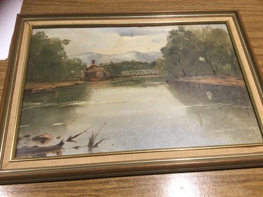
Painting
Hand painted by Margaret Quayle.Original painting of Heidelberg, Victoria by Margaret Quayle. River scene with house and bridge, in a wooden frame.paintings, artworks -
 University of Melbourne, Burnley Campus Archives
Photograph - Black and white print, Children Playing in the River, Unknown
... in the river (Yarra?) with a bridge above them. T H Kneen suggests...children rocks river bridge yarra Hawthorn railway Black ...Black and white photograph. Children standing on rocks in the river (Yarra?) with a bridge above them. T H Kneen suggests it is the Melbourne Hawthorn Railway Bridge and that The Boulevard now passes under the arch.children, rocks, river, bridge, yarra, hawthorn railway -
Port Melbourne Historical & Preservation Society
Photograph - Shipping using Webb Dock, Williamstown and various River Yarra berths, Ron Laing, 1986 - 1999
A set of 83 photographs of shipping using Webb Dock, Williamstown, various river berths and movements in the Yarra River 1986-1999mairangi bay, columbus australia, michigan highway, anro australia, toyofuji 8, columbus america, union rotoma, searoad tamar, antwerpen, contship jork, queensland star, kha bhum, columbus new zealand, city of port melbourne, dock express ii, direct kea, samas spirit, arafura, contship action, searoad mersey, ville de capella, australia bridge, juthia bhum, direct eagle, columbia star, torrons, hakuyou maru, berlin express, tourcoing, rabelis, bass trader, zim brisbane, australian advance, sea venus, morning light, matilda bay, ooclexporter, qiutte, lloydiana, direct kookaburra, nichigon maru, era, golden crux ii, canopus, stolt sincerity, ionikos, iron gippsland, ehjin, satucket, irene, paum monarch, torbon spirit, cgm, la perouse, amvella, transport - shipping, piers and wharves, ron laing, eclipse -
 Eltham District Historical Society Inc
Book, Jenny Brown et al, Out of the Mist; Osborne Peninsula, 2024
The Osborne Peninsula on the Yarra River at Warrandyte accommodates a limited number of properties and residents (70 households). The area is rich in geology and ecology, and an unusually rich endowment of human, built and creative history. Contents: Welcome: The landform: The River: Aboriginal occupation: The Miners: North Warrandyte :The Subdivision: The Lowes: The Osbornes: The Last Osborne: The Elders: The Relics: Dray Track: Water Wheel"Kauri Plaque: River track: Pines: Windmill Creek Bridge: The Koornong School: The Houses" Man Cave: MidCentury Classic: Enduring Original" Masterwork: The Muddies: The State Park: The Saving of Koornong Reserve: The Landcare Story: Flora and Fauna: The Vulnerable, Endangered and threatened: Birds: Mammals: "Waring" the wombat: Reptiles: Fish: Invertebrates: Flora: Fire. Published by the North Warrandyte (Osborne Peninsula) Landcare Group. Includes photos from EDHS collection.64 p. : ill., map ; 29.7 x 21 cm. (2 copies)yarra river, birrarung, dray track, fauna, geology, houses, indigenous history, koornong reserve, koornong school, lowe family, mining, mudbrick houses, north warrandyte, osborne family, warrandyte state park, water wheel, north warrandyte (osborne peninsula) landcare group, osborne peninsula -
 Eltham District Historical Society Inc
Photograph - Digital Photograph, Alan King, Nillumbik Shire Offices, Greensborough, 30 March 2008
Nillumbik Shire Council transferred to the former Diamond Valley Shire Offices in Greensborough after municipal restructuing. The offices became the official Nillumbik Shire Council Offices on 16 October 1995. The former Shire of Diamond Valley Civic Centre or Shire Office building was officially opened on 26th February 1972. Archtiects were A.K. Lines, McFarlane & Marshall and it was built by L.U. Simon Pty Ltd, The Diamond Valley Shire had been created in 1964 from part of the City of Heidelberg. On December 15, 1994 the Shire of Nillumbik was established. Under the Council amalgamations imposed by the Kennett government, the Shire of Eltham, Shire of Diamond Valley and City of Heidelberg ceased to exist with the establishment of Nillumbik Shire Council and the City of Banyule.The new Nillumbik shire surrended the west riding from Eltham to Banyule but in place gained parts of the former Diamond Valley Shire which itself had been created in 1964 from parts of the City of Heidelberg. Three unelected and non-local Commissioners were put in place by the government bringing democracy into question by many members of the local community. The Commissioners determined to abandon the former Shire of Eltham offices located in Main Road, Eltham and in turn occupy the former Shire of Diamond Valley offices located at the boundary of the new shire with Banyule, in Civic Drive, Greensborough. In July 1996 the Commissioners sold the former Eltham Shire Offices and had them bulldozed leading to many years of communiity protest over the process and future development applications. The site has remained vacant ever since. Published: Nillumbik Now and Then / Marguerite Marshall 2008; photographs Alan King with Marguerite Marshall.; p43 It was the need for roads that led to this district’s first council. In 1853 a committee was formed to improve the rough roads, some in Kangaroo Ground being almost impassable in winter.1 The committee fundraised by voluntary levies and grants to improve in particular, the main road between Kangaroo Ground and the Plenty River. From this committee arose the Eltham District Road Board, in 1856, which was the precursor to the Eltham Shire Council. The Board’s first chairman was Kangaroo Ground farmer, John Barr. Secretary was the former committee’s secretary, Andrew Ross, Kangaroo Ground’s first school teacher, and founder of the district newspaper, The Evelyn Observer.2 Most of the board’s income came from a toll-house north of the Lower Plenty Bridge, which funded such projects as a road from Kangaroo Ground to the Caledonia Diggings. In 1871 the Shire of Eltham was proclaimed, with its boundaries the same as those of the Road Board, and Councillor A Donaldson of Kangaroo Ground was the first president. Eltham was at the southern tip of the shire, which extended north to Kinglake and east beyond Yarra Glen. In 1878, part of Kinglake was added to the shire, while the area east of Watts River, near Healesville was removed. In 1912, then again in 1958, the shire was further reduced. Yarra Glen, Steels Creek, Tarrawarra, parts of Healesville and Christmas Hills, were transferred to the Shire of Healesville. In 1972 a smaller area, at Kinglake, was transferred to the Shire of Yea, leaving 277 square kilometres in the Eltham Shire. Perhaps no other Victorian municipality has had so many meeting places. Although from 1858 to 1904, the council convened at the office in the home of Secretary Charles Wingrove, the board, and later the council, also met at other more central locations.3 The board moved from the Fountain of Friendship Hotel to the Eltham Courthouse, to the Kangaroo Ground schoolhouse. It then met at the Kangaroo Ground Hotel, which some considered put it in danger of interruptions by people ‘the worse for liquor’.4 In 1885 the council met at the hall on Mr J Donaldson’s land at Kangaroo Ground. After Wingrove’s retirement, the council rented space at the Kangaroo Ground General Store and Post Office. Then, in 1917, the council bought the former office of The Evelyn Observer, after its printing works transferred to Hurstbridge. In 1934, fire destroyed the shire office, which was temporarily relocated to the Kangaroo Ground home of Shire Secretary, Mr P J McMahon. In 1941, the shire office moved to a new building (which included a public hall) in Eltham, at the corner of Arthur Street and Main Road, where the Eltham Village Shopping Centre was eventually built. Growth required new offices, which opened in 1965, on the former Shillinglaw property in Main Road.5 In 1994, as part of municipal restructuring under the Jeff Kennett Liberal Government, most of the Eltham Shire formed part of the new Shire of Nillumbik. It joined with the north section of the Diamond Valley Shire and parts of the Healesville and Whittlesea municipalities. The Diamond Valley Shire had been created in 1964, from part of the City of Heidelberg. Turbulence followed Nillumbik Shire’s formation. Under the Commissioners the council transferred to the former Diamond Valley Shire offices in Greensborough, and the Eltham council offices were demolished. In March 1997 the first five-member Nillumbik Council was elected. But, in October 1998, the government suspended the council and appointed an administrator . Early in 1999, shire residents voted to increase councillors to nine: comprising five ward councillors and four shire-wide councillors. Elections were held in March 1999. Then, before the March 2002 elections, nine new wards were created.6 In 2008 these were reduced to seven. Today [2008] the council governs a varied population of more than 60,000 people living in townships and on bush properties in the green wedge.This collection of almost 130 photos about places and people within the Shire of Nillumbik, an urban and rural municipality in Melbourne's north, contributes to an understanding of the history of the Shire. Published in 2008 immediately prior to the Black Saturday bushfires of February 7, 2009, it documents sites that were impacted, and in some cases destroyed by the fires. It includes photographs taken especially for the publication, creating a unique time capsule representing the Shire in the early 21st century. It remains the most recent comprehenesive publication devoted to the Shire's history connecting local residents to the past. nillumbik now and then (marshall-king) collection, greensborough, nillumbik shire council offices, civic drive -
 Melbourne Tram Museum
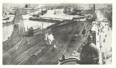
Photograph - Yarra River from Flinders St Station clock tower, Town and Country Journal, 1909
... and shipping, bridges Flinders St Station Yarra River wharves railways ...Photos show the Yarra river and the shipping turning basin that was used prior to the construction of the Spencer St bridge. In the view are are steam hauled suburban trains, Flinders St A signal box, Queensbridge, and the wharves on either side of the river. The viaduct was expanded to four tracks in 1915. Yields information about Yarra River, Flinders St railway station yards and shipping,Set of two photographs looking west from the Flinders St Station clocktower. over the Yarra River and station yards.On rear of both prints in ink: 1 – Melbourne - West from clock tower on Flinders St station - “Town and Country Journal 21/7/1909” Copy neg Mark Plummer collections ex late John Alfred collection. .2 - Melbourne, Looking west along Flinders St from clocktower of Flinders St station. Copy neg Mark Plummer collections ex late John Alfred collection. Has “T&C 20/12/09” in pencil on rear. bridges, flinders st station, yarra river, wharves, railways, signal boxes, queens bridge, shipping -
 Melbourne Tram Museum
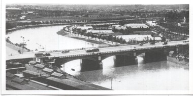
Photograph - Yarra River and Princes Bridge from Flinders St Station clock tower, Town and Country Journal, 1909
... Yarra River and Princes Bridge from Flinders St Station... Station clocktower. over the Yarra River and Princes Bridge.... Photos show the Yarra river looking east over Princes Bridge ...Photos show the Yarra river looking east over Princes Bridge. In both photos are cable trams, the rowing sheds and parts of Flinders St station. The first phtograph shows the nearly completed ramps from the platform, while the second has the former exit structure that allowed passengers to exit to Princes Bridge and St Kilda Road. Yields information about Yarra River, Flinders St railway station yards and Princes Bridge.Set of two photographs looking east from a Flinders St Station clocktower. over the Yarra River and Princes Bridge..1 – Melbourne Princes Bridge. Copy neg Mark Plummer collections ex late John Alfred collection. Has “T&C 20/12/09” in pencil on rear. .2 – Melbourne – Princes Bridge “Town and Country Journal 29/12/1909” Copy neg Mark Plummer collections ex late John Alfred collection.bridges, flinders st station, yarra river, railways, princes bridge, cable trams -
 Melbourne Tram Museum
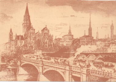
Artwork, other, Princes Bridge from the south bank of the Yarra River, c1900
... - Princes Bridge from the south bank of the Yarra River. Princes ...Sepia toned print of a drawing of Princes Bridge with St Paul's Cathedral and other buildings. Has a number of cable trams and horse drawn vehicles on the bridge. The artist has taken liberties and drawn the spires onto St Paul's cathedral and other buildings such as Princes Bridge railway station. The spires is most likely based on the proposed design at the time. They were built in 1926 to a changed design - see reference.Yields information about the Princes Bridge precinct.Reproduction of a Lithograph drawing - Princes Bridge from the south bank of the Yarra River.melbourne, princes bridge, horse drawn vehicles, st pauls cathedral, cable trams -
 Melbourne Tram Museum
Postcard, Marlborough Art Series, Princes Bridge Melbourne, 1910
... about Princes Bridge in 1910. tramways trams Yarra River Princes ...Photograph of Princes bridge Melbourne with one cable tram set crossing. In the background is the then new Flinders Street station building. Note the clock on the right hand side of the photograph that was later transferred to Spencer Street station. Yields information about Princes Bridge in 1910.postcard - decorative border with a photo of Princes Bridge within an oval - embossed. On the rear is a letter dated 21/12/1910. Card by Marlborough Art Series.See note on rear.tramways, trams, yarra river, princes bridge, cable trams, flinders street station, clocks -
 Whitehorse Historical Society Inc.
Article - Manningham Matters, Dr Richard Lay, Highways and Byways of Manningham, June 2021
August Schwerkolt walked between his properties at Northcote and Mitcham and probably crossed the Yarra River at the Banksia St bridge and took the ridge route which is now the Manningham, Doncaster and Mitcham Roads.August Schwerkolt walked between his properties at Northcote and Mitcham and probably crossed the Yarra River at the Banksia St bridge and took the ridge route which is now the Manningham, Doncaster and Mitcham Roads.non-fictionAugust Schwerkolt walked between his properties at Northcote and Mitcham and probably crossed the Yarra River at the Banksia St bridge and took the ridge route which is now the Manningham, Doncaster and Mitcham Roads.schwerkolt august, mitcham, doncaster road, mitcham road