Showing 28692 items
matching buldah-east-gippsland
-
 Lakes Entrance Historical Society
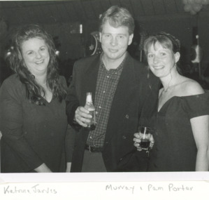
Photograph, Lakes Post Newspaper, Katrina Jarvis and Murray and Pam Porter, 1994 c
Black and white photograph of Katrina Jarvis and Murray and Pam Porter at unidentified venue East Gippslandeducation, buildings -
 Lakes Entrance Historical Society
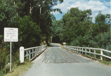
Photograph - Bonang Highway, East Gippsland Victoria, Marie Fish, Martins Creek Bridge, 1990 c
Colour photograph of wooden bridge over Martins Creek on Bonang Highway East Gippsland Victoriabridges, riv, roads and streets, engineering -
 Ringwood and District Historical Society
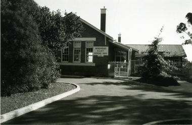
Photograph-B&W, Joan Walker, East Ringwood 2000- Formerly the East Ringwood Primary School No 4680, 2000
East Ringwood 2000- Formerly the East Ringwood Primary School No 4680- B&W Photo from Album 6501 -
 Ringwood and District Historical Society
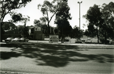
Photograph-B&W, Joan Walker, East Ringwood 2000-Maroondab Club & East Ringwood Football Ground, 2000
East Ringwood 2000-Maroondab Club & East Ringwood Football Ground- B&W Photo from Album 6501 -
 Ringwood and District Historical Society
Photograph-B&W, Joan Walker, East Ringwood 2000-3rd Ringwood East Scouts in 'Knaith Park', 2000
East Ringwood 2000-3rd Ringwood East Scouts in 'Knaith Park'- B&W Photo from Album 6501 -
 Orbost & District Historical Society
book, Hepburn, Dorothy, State School Number 3267 Lower Bendoc East Gippsland Victoria, C 2002
Located near the NSW border in the far east of Victoria, the Bendoc school served the needs of a rural population which opened the land to grazing at the turn of the century. It opened on September 8 1896. In December 1956 falling attendances forced the Education Department to close it. It is interesting to note that children here sought their secondary education in NSW. The first head teacher) was John M. Cass and the last R R King. In 1953-54 Lower Bendoc operated part-time with Goongerah. In 1955 it regained full-time status, but in 1956 worked part-time with Tubbut. Author, Dorothy Hepburn, attended Bendoc State School.This is a useful reference tool on the history of Bendoc.A spiral bound book with a plastic sheet front. The cover is white with black print and a b/w photo of a man sitting on a wooden chair outside a log building . Underneath is written "FROM HUMBLE BEGINNINGS TO FINAL CLOSURE".bendoc-state-school -
 Lakes Entrance Historical Society
Book, Duncan, Brad and Nicolson, Oona, Gippsland Ports Maritime Cultural Heritage Desk Study, 2007
Findings of a maritime archaeological/cultural heritage desk study of Lakes Entrance, East Gippsland, Victoria, Australiareports, ships and shipping, maritime history -
 Orbost & District Historical Society
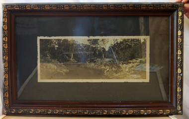
framed black and white photograph, C1920
Boggy Creek Bridge was built in 1916 as part of the Bairnsdale to Orbost extension to the main Gippsland Railway, and is situated in the middle of the township of Nowa Nowa, crossing a steep-sided and well-timbered creek-valley. This section of the line closed in 1987. This item is a pictorial record of the Boggy Creek railway bridge on the East Gippsland line. This bridge plays a major part in the identity and history of the town of Nowa Nowa, since Boggy Creek’s steep sided valley divides the township into two components.A black / white photograph of a bridge across a river in the bush. It is under glass in a brown wooden frame which has gold decorated edges. There appears to be a man sitting on rocks in the right front foreground.on front of photograph - "Nowa Nowa Creek, Gippsland, Victoria, Sears, Copyright"boggy-creek-nowa-nowa east-gippsland-railway bridge-rail -
 Ringwood and District Historical Society
Photograph-B&W, Joan Walker, East Ringwood 2000-Railway Avenue looking East to the junction of Victoria Street, 2000
East Ringwood 2000-Railway Avenue looking East to the junction of Victoria Street- B&W Photo from Album 6501 -
 Ringwood and District Historical Society
Photograph-B&W, Joan Walker, East Ringwood 2000-Railway Avenue looking East from Laurence Grove, 2000
East Ringwood 2000-Railway Avenue looking East from Laurence Grove- B&W Photo from Album 6501 -
 Ringwood and District Historical Society
Photograph-B&W, Joan Walker, East Ringwood 2000-Railway Avenue looking East from Laurence Grove, 2000
East Ringwood 2000-Railway Avenue looking East from Laurence Grove- B&W Photo from Album 6501 -
 Ringwood and District Historical Society
Photograph-B&W, Joan Walker, East Ringwood 2000-Railway Avenue Looking East from Dublin Road, 2000
East Ringwood 2000-Railway Avenue Looking East from Dublin Road- B&W Photo from Album 6501 -
 Ringwood and District Historical Society
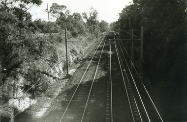
Photograph-B&W, Joan Walker, East Ringwood 2000-Eastfield Road Bridge looking West To East Ringwood, 2000
East Ringwood 2000-Eastfield Road Bridge looking West To East Ringwood- B&W Photo from Album 6501 -
 Ringwood and District Historical Society
Photograph-B&W, Joan Walker, East Ringwood 2000-Maroondab Club in Mount Dandenong Road Ringwood East, 2000
East Ringwood 2000-Maroondab Club in Mount Dandenong Road Ringwood East- B&W Photo from Album 6501 -
 Ringwood and District Historical Society
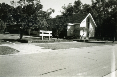
Photograph - Photograph-B&W, Joan Walker, East Ringwood 2000-St Stephens Uniting Church in Freeman Street East Ringwood, 2000
East Ringwood 2000-StStephens Uniting Church in Freeman Street East Ringwood- B&W Photo from Album 6501 -
Lakes Entrance Historical Society
Book, Hawkins Richard, Creeks and Harbours of the Gippsland Lakes by Richard Hawkins, 1984
This book has been updated, all three updates in library VTMH 444.1, 444.2, 444.3. Last update 2000Survey and comprehensive boating guide to the creeks and harbours and waterways of the Gippsland Lakes Victoria at December 1984 contains maps, charts giving depth. Brief history of the region.waterways, boats and boating -
 Lakes Entrance Historical Society
Photograph - Steam Engine, Gippsland Victoria
Contractor with steam engine often travelled to district farms as requiredBlack and white enlarged photograph of a large steam traction engine showing container at back holding wood for boiler and smoke stack. Driver on board Gippsland Victoriaagriculture, engineering -
 Orbost & District Historical Society
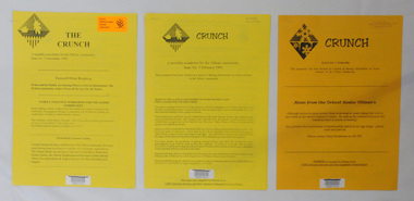
newsletters, The Crunch, 1995 1996
These newsletters were created as an ACCESS project at the Orbost centre of TAFE (Technical and Further Education). Community newsletters are published by local groups and provide community news and information. In small rural communities they are an important communication medium.Three issues of a newsletter titled The Crunch. This was a newsletter for the Orbost community and contains articles on Orbost events. Most articles refer to TAFE Outreach Services. 2407.1 and 2407.2 are printed on yellow paper. 2407.3 has 3 orange sheets and 2 yellow sheets. All are stapled. 2407.1 has a label on the front with East Gippsland Shire Library and a bar code. 2407.2 has a bar code and LOCAL Newsletter written in pencil. 2407.3 has a stamp - EAST GIPPSLAND LIBRARY SERVICE and LOCAL written in pencil.newsletters tafe-orbost -
Lakes Entrance Historical Society
Book, Davidson, Rachael, The Nicholson River Railway Bridge, 2004
Research, interpretation and management recommendations for the Nicholson River Railway Bridge, East Gippsland, Victoria, by a Forestec student.bridges, transport -
 Lakes Entrance Historical Society
Photograph - Mr Stringy, 1939 c
This stump one of several replacements. Black and white photograph of carved tree stump on Omeo Road known as Mr Stringy East Gippslandsculpture, local history -
 Lakes Entrance Historical Society
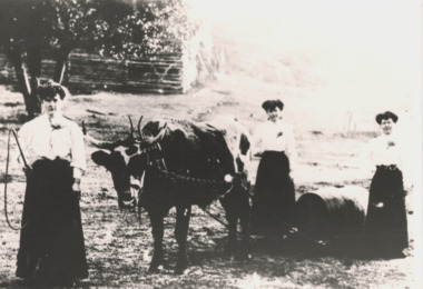
Photograph - Bullock Team, Three ladies with bullock team, Gippsland Victoria, 1900 c
Black and white photograph of three ladies wearing full length skirts with small bullock team pulling a drum, lady in front holding a whip on farm in Gippsland Victoriatransport, clothing -
 Ringwood and District Historical Society
Photograph-B&W, Joan Walker, East Ringwood 2000-East Ringwood Tennis Courts and the Cnr: Mount Dandenong & Dublin Roads, 2000
East Ringwood 2000-East Ringwood Tennis Courts and the Cnr: Mount Dandenong & Dublin Roads.- B&W Photo from Album 6501 -
 Ringwood and District Historical Society
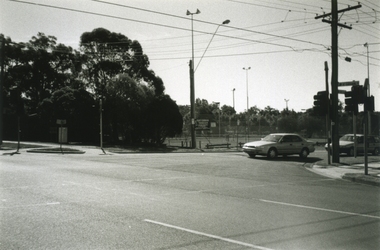
Photograph-B&W, Joan Walker, East Ringwood 2000-The East Ringwood Railway Station from the car park opposite IGA Supermarket, 2000
East Ringwood 2000-The East Ringwood Railway Station from the car park opposite IGA Supermarket- B&W Photo from Album 6501 -
 Ringwood and District Historical Society
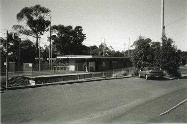
Photograph-B&W, Joan Walker, East Ringwood 2000-Taken from the Eastfield Road Bridge looking towards the East Ringwood Station, 2000
East Ringwood 2000-Taken from the Eastfield Road Bridge looking towards the East Ringwood Station- B&W Photo from Album 6501 -
 Wodonga & District Historical Society Inc
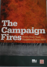
Book - The Campaign Fires - North-East/East Gippsland Fires 2003, Lyndel Hunter, 2003
A description of efforts to fight the bushfires in Gippsland in 2003, including maps and illustrations This volume was published as a tribute to the work of staff and volunteers who put themselves at risk to protect local communities. It shows the impact on those communities in Victoria and the support they gave to those involved in fighting largest bushfires in Victoria for 60 years. The Alpine bushfires started on 8 January 2003, a day of Total Fire Ban. Lightning ignited 87 fires in the North-East and East Gippsland regions. Eight of these fires were unable to be contained; they joined together to form the largest fire in Victoria since the Black Friday fires in 1939. The majority of the area burnt in Victoria was public land, 1.19 million hectares of parks and forests, including 60 per cent of the Alpine National Park and 81 per cent of the Mt Buffalo National Park. Firefighting efforts were made difficult in hard to access, remote forest terrain. Approximately 90,000 hectares of private land was burnt.This publication of 119 pages features text, colour images, maps and detailed information related to the 2003 bushfires in Victoria.non-fictionA description of efforts to fight the bushfires in Gippsland in 2003, including maps and illustrations This volume was published as a tribute to the work of staff and volunteers who put themselves at risk to protect local communities. It shows the impact on those communities in Victoria and the support they gave to those involved in fighting largest bushfires in Victoria for 60 years. The Alpine bushfires started on 8 January 2003, a day of Total Fire Ban. Lightning ignited 87 fires in the North-East and East Gippsland regions. Eight of these fires were unable to be contained; they joined together to form the largest fire in Victoria since the Black Friday fires in 1939. The majority of the area burnt in Victoria was public land, 1.19 million hectares of parks and forests, including 60 per cent of the Alpine National Park and 81 per cent of the Mt Buffalo National Park. Firefighting efforts were made difficult in hard to access, remote forest terrain. Approximately 90,000 hectares of private land was burnt.forest fires -- victoria, bushfires, fires prevention and control -
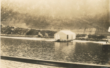 Lakes Entrance Historical Society
Photograph, Nyerimilang Jetty, Reeves channel Gippsland Lakes Victoria, Easter 1928
Sepia photograph of track to Nyerimilang Jetty soon after opening showing track down side of cliff to jetty and boat shed adjacent to shore, Reeves channel Gippsland Lakes Victoria waterways, boats and boating -
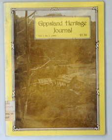 Orbost & District Historical Society
book, E-Gee Printers, 1986
Gippsland Heritage Journal is a journal, produced about every nine - twelve months, for those interested in regional, local and family history in Gippsland, Victoria, Australia. It is compiled by Meredith Fletcher, Debbie Squires and Linda Barraclough and includes a diverse range of articles, both academic and non-academic. Since No.24 it has been a partially refereed journal. Both copies were used at Orbost High School / Orbost Secondary College.This is a useful research tool on the history of Gippsland.Tw copies of a 64 pp magazine, (2322.1 is plastic covered), titled Gippsland Heritage Journal. The front cover is yellow with a b/w photograph of the Culhane house at Crooked River near Grant. The magazine contains photographs, articles on the history of Gippsland. -
Lakes Entrance Historical Society
Book, Cunningham Cliff, Aboriginal Scar Tree Bruthen Valley, 2004
Research interpretation and management recommendations for the Aboriginal Scar tree in Bruthen Valley, East Gippsland Victoria by a forestec studentaboriginals, transport, vegetation -
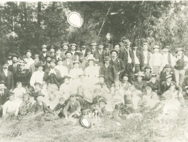 Lakes Entrance Historical Society
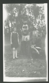
Photograph - Fashion, 1910 c
Group appear to be on a Sunday excursion as all in best clothesBlack and white photograph of group of men, women and children posed for the camera in a bush setting in East Gippsland Victoriacelebrations, clothing -
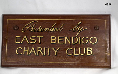 Bendigo Military Museum
Plaque - EAST BENDIGO PLAQUE
This belonged to East Bendigo Honour Board WW2 held at this museum. Refer Cat No 7498.A varnished wooden plaque. It has gold painted lettering with dark printed shadow effect. It has curved edging. It is rectangular shaped.“Presented by East Bendigo Charity Club”war, east bendigo, honour boards