Showing 750 items matching "chart"
-
 Lakes Entrance Historical Society
Book, Batterbee, John and Williams, Roy, A Guide to Affordable Antiques and Collectables in Australia, 1994
A guide to Australia's antique heritage. Includes a time chart of styles of furniture, jewellery, silverware, glassware, crockery, clocks and various ephemera. Indexed.antiques -
Creswick Campus Historical Collection - University of Melbourne
Ephemera, 1970-1990
Botanical Teaching notes and identification charts 1970's - 90'sTeaching notes -
 Vision Australia
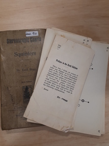
Education kit - Object, A. Francke, Stereoscopic charts for squinters [by] Dr. Emil Hegg
A set of 70 (incomplete as full set believed to be 85 cards) black and white and colour stereoscopic charts, divided into series Includes geometric, pictorial and photographic examples of charts and Schlechteres Auge test. An instructional leaflet is also included. These featured images thought to strengthen the eye muscles.1 rectangular fawn cardboard box sleeve which contains specially printed cards with pictures and text6th editionequipment, emil hegg -
 National Vietnam Veterans Museum (NVVM)
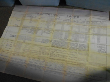
Poster - Poster, Information Board, Pacification tasks
Paper wall chart explaining the definition of and responsibilities of all aspects, military and civilian groups involved in the pacification process. Includes US advisory responsibilitieswall chart, pacification tasks, aattv -
 Ambulance Victoria Museum
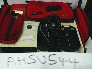
Monitor defibrillator, Lifepak 10, Physio-Control Corporation, Circa 1982
Entered service in around 1982. Remained in service for around 4 years and mainly used in ural areas.Cream coloured electrical equipment with carry handle. Green monitor screen and paper chart printer built in. Red fabric carry case on item.PHYSIO-CONTROLdefibrillator, resuscitation -
 Federation University Art Collection
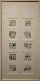
Work on paper - Printmaking - Screenprint, Allan Mann, 'Charts and Ciphers' by Allan Mann, 1994, 1994
This item is part of the Federation University Art Collection. The Art Collection features over 1000 works and was listed as a 'Ballarat Treasure' in 2007..1) Eight screenprints on Fabriano 5 paper framed together. The first five are 'charts' and the remainder are 'ciphers' .2) Black box with eight screenprints.art, artwork, allan mann, mann, charts, cyphers, artist's book, printmaking, screenprint -
 Royal Melbourne Yacht Squadron
Award - L.A. Nangle Perpetual Trophy
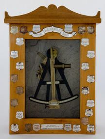
In 1961, George Venables resigned after 38 years of faithful service to the Club. He spent the first 21 years as Head Steward, the remainder as Secretary, a position that in his latter years became Secretary/Manager. Prior to leaving, he presented to the Club the Quadrant once owned and used by his father when one of the Navigating Officers aboard H.M.V.S. Cerberus. This was to lay idle in as cupboard in the Office until one day seen by then Commodore Les Nangle, who decided to put it to good use. Following being mounted in a case, July 1969, it was allocated as a trophy by Commodore Les Nangle. Originally it was for a Distance event for 1st Division and One-Design Classes, with the first event season 1969-70, being from St Kilda to Mornington, won by Brian Morris skippering the Diamond Class yacht, Vulpine. In an endeavour to raise interest in Twilight events for both the racing and Club revenue, the trophy was re-allocated, December 1990, for a Combined Club and Classes, including Trailerable yachts, Mid-Week Summer Twilight Pursuit Series, held on consecutive Wednesday’s, commencing January 1991, of seven, later amended to nine heats without spinnakers, initially with trophies awarded after each heat. The best five results to count, contested in accordance with the VYC handicapping system. Trophy was first won Season 1971-1972, by Roy Duncan with his Tumlare, Marie, From 2007 onwards the contests were amended to allow for at least seven heats to be set in the race calendar with a minimum of 5 heats to be conducted to constitute a series. Seventy percent of results to count for the series scores when the number of heats exceeded ‘Five’.Brass quadrant upon coastal chart, enclosed in a glass fronted wooden case. Silver winners inscription shields attached around edge of case.L. A. NANGLE PERPETUAL TROPHY THIS QUADRANT IS OF THE TYPE USED BY THE EARLY AUSTRALIAN NAVIGATORSl.a. nangle, perpetual, trophy -
 Ballarat Tramway Museum
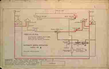
Drawing, State Electricity Commission of Victoria (SECV), "Automatic Brake operation charts", 1948
Charts 2, 3, 4 and 6 or drawings showing automatic brake operations for possibly Ballarat tram 26 which was trialled in Ballarat during 1948 See item 9894 for instructions and item 9891 for a memo regarding operations. Shows the various stages of operations. Charts 1 and 5 missing.Demonstrates SECV document and chart of operations about the trialing of automatic braking systems on tram 26.Set of four foolscap sheets - dye line prints, marked up in red ink.tramways, ballarat, brakes, tramcar brakes, braking, tram 26 -
 B-24 Liberator Memorial Restoration Australia Inc
Map - US World War II multi-coloured map, Side 1 - No. C-47 South Borneo, Side 2 - No. C-48 West Java, 1944
Silk and rayon maps were produced by the United States (c. 7.5 million in total), Great Britain (some 1.75 million in total) and Australia during World War II. They were issued to Allied military personnel as part of 'escape and evasion' kits.This map, printed on acetate rayon, is an original US 'escape and evasion' kit map from World War II.A multi-coloured, contoured, double-sided map printed on acetate rayon AAF Cloth Chart Side 1 - No. C-47 South Borneo Side 2 - No. C.48 West Javaunited states of america, silk and rayon maps, world war ii, a191 -
 Kiewa Valley Historical Society
Chart - Cattlemen Families of the Kiewa Valley and their Brands, Cattle Grazing on the Bogong High Plains
Cattle were taken up to the Bogong High Plains by the Kiewa Valley farmers who had a lease there in their allocated area. The cattle roamed and were mustered in late summer. At this time they also sorted the cattle using the cattle's brands for identification.Types of breeds bred in the Kiewa Valley and the names of families who grazed cattle on the Bogong High Plains is of historical interest and also gives an insight into the history of cattle grazing.White paper, black print. Chart's headings: Name of Family (25 in alphabetical order), Run No., Earmark, Brand and Log and Breed. 29th Feb. 1972 cattle grazing, bogong high plains, kiewa valley families, cattle breeds, cattle brands -
 Bendigo Military Museum
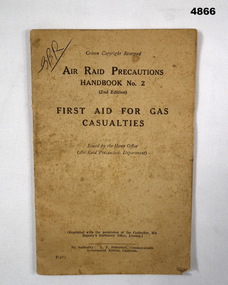
Booklet - TRAINING BOOKLET, GAS WARFARE, Commonwealth Government Printer, First Aid for Gas Casualties, c1939-45
Issued by the Home Office - Air Raid Precautions Department, UK. Reprinted with permission from HM Stationery office. Authority: L.F. Johnson, Commonwealth Government Printer Canberra. Pocket size booklet, khaki cover with black ink printing. There are 48 pages consisting of text, charts and drawings. The booklet has two staples on the spine.Front top left hand corner has G.B.R. written. Inside first page has G.B. Richards written.ww2, gas warfare, casualties, first aid -
 Bendigo Historical Society Inc.
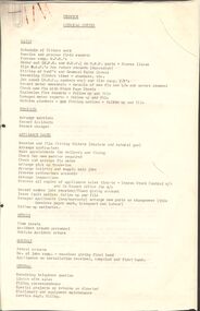
Document - CASTLEMAINE GAS COMPANY COLLECTION: SERVICE CLERICAL DUTIES
8 Pages document outlining the Service Clerical Duties: Daily, Weekly and Monthly plus Vehicles, Appliance Sales and General duties with comments and chart flows.business, retail, gas and fuel -
Port Melbourne Historical & Preservation Society
Document - Chart illustrating shipping flags, 1938
Chart illustrating shipping flags - the International Code of Signals including alfa, substitutes, numeral pendants and naval numerals. From Country Life supplement 1938.transport - shipping -
 Bendigo Historical Society Inc.
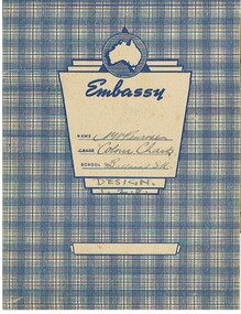
Document - NORMAN PENROSE COLLECTION - COLOUR CHARTS & DESIGN
Document. Norman Penrose collection: blue check pattern exercise book containing notes on Colour Design and 6 loose pages of colour wheels/charts.N. Penroseperson, bendigo, norman william penrose, norman penrose collection, colour and design -
 Queenscliffe Maritime Museum
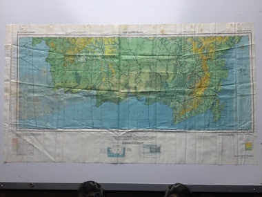
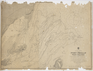
Map - Survey Charts, Port Phillip West Channel
These charts show changes to the depth levels surrounding Queenscliff. Earlier chart does not show the cut which can be seen in the later chart. The creation of the cut and subsequebt dredging of it has changed the shoreline due to shifting sand.Two charts of the Port Phillip West Channel, reference number 309. One was engraved in 1903, the other a new 1935 edition last revised in 1961.Port Phillip West Channelport phillip, queencliff channel, charts, soundings -
 Sunbury Family History and Heritage Society Inc.
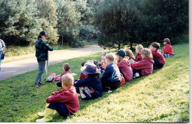
Photograph, Nature studies, 31st March 1996
The students from the former Bulla Primary School were enjoying an excursion to a nearby nature reserve to study some of the insect life to be found in the waterway and the native plants in that environment. The nature excursion was part of the students' environmental and science studies.A non-digital coloured photograph of children sitting on a grassy hillside listening to a teacher who is holding up a large chart while explaining something to them.bulla primary school, nature studies, bulla, school excursions -
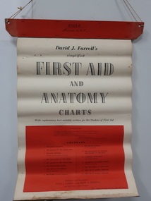 Kiewa Valley Historical Society
Roll of Charts - First Aid and Anatomy
An educational tool for the study of the human body. Prior to digital pictures - wall charts were used.Used as a teaching aid in the Kiewa Valley before digitisation15 sheets held together by red very thick cardboard with string for hanging attached. For educating people on the human body by displaying on the wall.first aid, education, anatomy, wall charts, health -
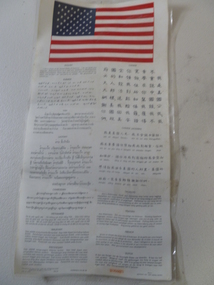 National Vietnam Veterans Museum (NVVM)
Poster, Laminated Poster, 1965
(shortened version) Poster with American flag and words. I am a citizen of the USA I not speak your language. Please take me to someone who can protect me. My government with reward you. Written in many languages underneath.Published by aeronautical chart and informationcentre US Airforce. Lithographed Dec 1965 406825 South East Asia - West central Pacificposter -
 Flagstaff Hill Maritime Museum and Village
Container - Chart Case
The iron-hulled, four-masted barque, the Falls of Halladale, was a bulk carrier of general cargo. She left New York in August 1908 on her way to Melbourne and Sydney. In her hold, along with 56,763 tiles of unusual beautiful green American slates (roofing tiles), 5,673 coils of barbed wire, 600 stoves, 500 sewing machines, 6500 gallons of oil, 14400 gallons of benzene, and many other manufactured items, were 117 cases of crockery and glassware. Three months later and close to her destination, a navigational error caused the Falls of Halladale to be wrecked on a reef off the Peterborough headland at 3 am on the morning of the 15th of November, 1908. The captain and 29 crew members all survived, but her valuable cargo was largely lost, despite two salvage attempts in 1908-09 and 1910. ABOUT THE ‘FALLS OF HALLADALE’ (1886 - 1908) Built: in1886 by Russell & Co., Greenock shipyards, River Clyde, Scotland, UK. The company was founded in 1870 (or 1873) as a partnership between Joseph Russell (1834-1917), Anderson Rodger and William Todd Lithgow. During the period 1882-92 Russell & Co., standardised designs, which sped up their building process so much that they were able to build 271 ships over that time. In 1886 they introduced a 3000 ton class of sailing vessel with auxiliary engines and brace halyard winches. In 1890 they broke the world output record. Owner: Falls Line, Wright, Breakenridge & Co, 111 Union Street, Glasgow, Scotland. Configuration: Four masted sailing ship; iron-hulled barque; iron masts, wire rigging, fore & aft lifting bridges. Size: Length 83.87m x Breadth 12.6m x Depth 7.23m, Gross tonnage 2085 ton Wrecked: the night of 14th November 1908, Curdies Inlet, Peterborough south west Victoria Crew: 29 The Falls of Halladale was a four-masted sailing ship built-in 1886 in Glasgow, Scotland, for the long-distance cargo trade and was mostly used for Pacific grain trade. She was owned by Wright, Breakenridge & Co of Glasgow and was one of several Falls Line ships, all of which were named after waterfalls in Scotland. The lines flag was of red, blue and white vertical stripes. The Falls of Halladale had a sturdy construction built to carry maximum cargo and able to maintain full sail in heavy gales, one of the last of the ‘windjammers’ that sailed the Trade Route. She and her sister ship, the Falls of Garry, were the first ships in the world to include fore and aft lifting bridges. Previous to this, heavily loaded vessels could have heavy seas break along the full length of the deck, causing serious injury or even death to those on deck. The new, raised catwalk-type decking allowed the crew to move above the deck stormy conditions. This idea is still used today on the most modern tankers and cargo vessels and has proved to be an important step forward in the safety of men at sea. On 4th August 1908, with new sails, 29 crew, and 2800 tons of cargo, the Falls of Halladale left New York, bound for Melbourne and Sydney via the Cape of Good Hope. The cargo on board was valued at £35,000 and included 56,763 tiles of American slate roofing tiles (roof slates), 5,673 coils of barbed wire, 600 stoves, 500 sewing machines, 6,500 gallons of oil, 14,400 gallons of benzene, plumbing iron, 117 cases of crockery and glassware and many other manufactured items. The Falls of Halladale had been at sail for 102 days when, at 3 am on the night of 14th November 1908, under full sail in calm seas with a six knots breeze behind and misleading fog along the coast, the great vessel rose upon an ocean swell and settled on top of a submerged reef near Peterborough on the south-west Victoria’s coast. The ship was jammed on the rocks and began filling with water. The crew launched the two lifeboats and all 29 crew landed safely on the beach over 4 miles away at the Bay of Islands. The postmistress at Peterborough, who kept a watch for vessels in distress, saw the stranding and sent out an alert to the local people. A rescue party went to the aid of the sailors and the Port Campbell rocket crew was dispatched, but the crew had all managed to reach shore safely by the time help arrived. The ship stayed in full sail on the rocky shelf for nearly two months, attracting hundreds of sightseers who watched her slowly disintegrate until the pounding seas and dynamiting by salvagers finally broke her back, and her remains disappeared back into deeper water. The valuable cargo was largely lost, despite two salvage attempts in 1908-09 and 1910. Further salvage operations were made from 1974-1986, during which time 22,000 slate tiles were recovered with the help of 14 oil drums to float them, plus personal artefacts, ship fittings, reams of paper and other items. The Court of Marine Inquiry in Melbourne ruled that the foundering of the ship was entirely due to Captain David Wood Thomson’s navigational error, not too technical failure of the Clyde-built ship. The shipwreck is a popular site for divers, about 300m offshore and in 3 – 15m of water. Some of the original cargo can be seen at the site, including pieces of roof slate and coils of barbed wire. The Falls of Halladale shipwreck is listed on the Victorian Heritage Register (No. S255). She was one of the last ships to sail the Trade Routes. She is one of the first vessels to have fore and aft lifting bridges. She is an example of the remains of an International Cargo Ship and also represents aspects of Victoria’s shipping industry. The wreck is protected as a Historic Shipwreck under the Commonwealth Historic Shipwrecks Act (1976).Chart Case, copper with screw-plug at one. Holed, heavily corroded and etched away. Artefact Reg No FoH/8, recovered from the wreck of the Falls of Halladale. flagstaff hill, warrnambool, shipwrecked coast, flagstaff hill maritime museum, maritime museum, shipwreck coast, flagstaff hill maritime village, great ocean road, falls of halladale, shipwreck peterborough, 1908 shipwreck, great clipper ships, russell & co., chart case -
Bendigo Historical Society Inc.
Document - DRIVERS LUBRICATION CHART
BHS CollectionDrivers Lubrication Chart; General Arrangement of A.E.C. Chassis with pressed steel frame and Taylor Engine Type YB /YC. Produced by Associated Equipment Co. London.machinery, engines - internal combustion, chassis lubrication -
Lakes Entrance Historical Society
Book, Hawkins Richard, Creeks and Harbours of the Gippsland Lakes by Richard Hawkins, 1984
This book has been updated, all three updates in library VTMH 444.1, 444.2, 444.3. Last update 2000Survey and comprehensive boating guide to the creeks and harbours and waterways of the Gippsland Lakes Victoria at December 1984 contains maps, charts giving depth. Brief history of the region.waterways, boats and boating -
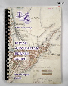 Bendigo Military Museum
Administrative record - 75th Anniversary of the Royal Australian Survey Corps - Annual Report 1989/90, Royal Australian Survey Corps, 1990
Royal Australian Survey Corps Annual Report 1989/90 of all mapping and charting carried out during that periodAn A4 booklet, glossy pages, map index of all mapping scales, 17 pages and Annexes, plastic ring bindingroyal australian survey corps, rasvy, fortuna, army survey regiment, army svy regt, asr -
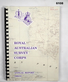 Bendigo Military Museum
Administrative record - Royal Australian Survey Corps - Annual Report 1990/91, Royal Australian Survey Corps, Late 1991
Annual Report detailing the status of Australian mapping, charting and geodesy for the period 1 Jul 90 - 30 Jun 91A4 soft covered book, glossy paper pages and plastic pockets containing maps. Plastic ring bindingTop right hand corner "2IC Tech WO"royal australian survey corps, rasvy, fortuna, army survey regiment, army svy regt, asr -
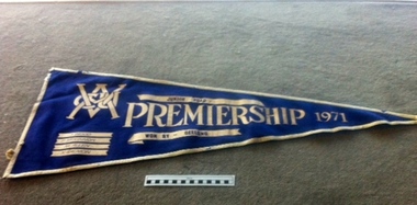 Geelong Cycling Club
Pennant, 1971
Amateurs during this period were strong. Ian Wood had won a schoolboys championship. This pennant charts his progress.Record of strength of Juniors in the ClubTriangular Pennant in blue felt trimmed with white felt. Wording regarding event and winners is embossed in white over the navy blue felt."VACU/Junior Road/Premiership 1971/Won by Geelong/I Wood/P McKinnon/M Allen/K Salmon"vacu; junior road; premiership; 1971; geelong cycling club; gcc; i. wood; p. mckinnon; m. allen; k. salmon; -
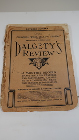 Kiewa Valley Historical Society
Book - Farming - Pastoral & Agricultural, Dalgety's Review 1906-1907
Dalgety's is a stock and station agent who produced a 'monthly record / of Australian Pastoral / and Agricultural Affairs / with Commercial news / and General information.' 1906 was the 14th year of publication.The Kiewa Valley consisted only of farming until the late 1940s when the Kiewa Hydro Electric Scheme commenced in the Upper Kiewa Valley creating the townships of Bogong and Mt Beauty and the corresponding infrastructure. This book would have been subscribed to (9pence) by local farmers all the way along the valley.Paper cover with black print and sketch of a sheep's head with horns in the centre. It has 140 pages which include black & white print of articles, advertisements, charts and photos.dalgety's review 1906, kiewa valley farmers, stock and station agent -
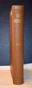 Warrnambool and District Historical Society Inc.
Book, Walter Scott, Australia, Cost Accounting, 1944
This accounting text book is from the collection of items relating to Warrnambool Woollen Mill.This is a book of 787 pages. It contains printed text, diagrams, charts and sample accounting sheets. The cover is brown with gold printing on the spine. There are two loose sheets of typed material.non-fictionThis accounting text book is from the collection of items relating to Warrnambool Woollen Mill.warrnambool woollen mill, antiquarian text books, cost accounting -
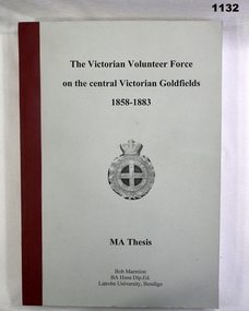 Bendigo Military Museum
Book, The Victorian Volunteer Force on the Central Victorian Goldfields 1858-1883, 2003
Soft cover, buckram, spine binding. Grey coloured, black writing with image of army badge in centre. Pages 215 Illustrated with black and white photos, statistics and charts.:Donated by Bob Marmion June 2004"books-military-history, military history-volunteer forces -
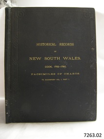 Flagstaff Hill Maritime Museum and Village
Book, The Historical Records of New South Wales
"The Historical Records of New South Wales Cook 1762-1781 Facsimiles of Charts to accompany Vol1, Part 1 (7263.01)" Publisher: Government Printer Sydney Date: 1893994 written on spine Inside front cover has a sticker that reads Warrnambool Mechanics Institute and Free Library warrnambool, shipwrecked-coast, flagstaff-hill, flagstaff-hill-maritime-museum, maritime-museum, shipwreck-coast, flagstaff-hill-maritime-village, shipwrecked-artefact, book, warrnambool mechanics’ institute, mechanics’ institute, the historical records of new south wales -
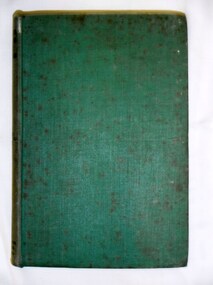 Bay Steamers Maritime Museum
Book, W. Laws, Electricity Applied to Marine Engineering, 1943
Green hard cover book of 286 pagesSticker on inside front cover ÄDMIRALTY CHART AGENTS / BOOKSELLERS & STATIONERS / J. DONNE & SON / 349 POST OFFICE PLACE / MELBOURNE -
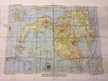 B-24 Liberator Memorial Restoration Australia Inc
Map - US World War II multi-coloured map - Philippine Series, No. C-43 Mindanao Series, No. C-44 North Borneo, 1944
Silk and rayon maps were produced by the United States (c. 7.5 million in total), Great Britain (some 1.75 million in total) and Australia during World War II. They were issued to Allied military personnel as part of 'escape and evasion' kits.This map, printed on acetate rayon, is an original US 'escape and evasion' kit map from World War II.A multi-coloured, contoured, double-sided map printed on acetate rayon AAF Cloth Chart - Philippine Series Side 1 - No. C-43 Mindanao Series Side 2 - No. C.44 North Borneounited states of america, silk and rayon maps, world war ii