Showing 386 items matching "first settlement"
-
 Eltham District Historical Society Inc
Photograph - Digital Photograph, Marguerite Marshall, Eltham Lower Park, 20 April 2008
Originally a race course, the park has brought the community together with a variety of activities. Published: Nillumbik Now and Then / Marguerite Marshall 2008; photographs Alan King with Marguerite Marshall.; p45 Once used for horse racing, which attracted visitors from Melbourne, the Eltham Lower Park has brought the community together with a wide range of activities. Horse riding is now enjoyed as a recreation in the park as are other sports. The park also includes the Diamond Valley Railway miniature trains and a sanctuary for the rare and vulnerable Eltham Copper Butterfly. Eltham Lower Park, with other parks, forms an almost continuous green band from Eltham’s centre, along the Diamond Creek to the Yarra River.1 Before European settlement the Wurundjeri people met on this land, particularly at the junction of the Diamond Creek with the Yarra River, which they called Birr-arung. This is commemorated by the sculpture, Not just a Pretty Place by Aleks Danko, winner of the 2000 Nillumbik Art in Public Places Award. The first European to settle here was probably Henry Foley, who in 1841 used it as part of his pastoral run. Foley sold his leasehold to Joseph Wilson in 1845, who soon after sold it to Frederick Falkiner. During the 1840s the future park was part of a government square mile (2.6 sqkm) reserve, north of the Yarra, within the Parish of Nillumbik, later named Eltham. Soon the land was used for horse racing after nearby residents cleared ten acres (4ha) in the early 1850s. A three-quarter of a mile (1.2km) race secured the winner the £10 Publican’s Prize. In response to popular demand, the newly formed Eltham District Road Board petitioned the Surveyor General of the Colony of Victoria, in 1856, for 36 acres (14.6ha) of crown land for a racecourse and recreation. By 1858 the Eltham races had become an institution. ‘Many skirmishes occurred and the way home was paved with temptation, with sly-grog for sale.3 In the early 1870s, two jockeys were sons of the police officer in charge of the Eltham Police Station, Miles S Lyons. Another ten acres (4ha) was added to the area in 1866 and 12 acres (4.8ha) – Hohnes Hill – in 1870. In 1866, two acres (0.8ha) on the creek banks became an animal pound with William Walsh the pound keeper in 1870, but this was later incorporated into the park. By 1877 the area was called a public park but horse racing and training continued into the 1920s. In the mid-1900s trotters were trained on a circuit road. In 1953 the Eltham Pony Club was established and used a cross-country course on Hohnes Hill. From the mid 1950s the club held the Eltham Easter Fair at the park, later to include a procession along Main Road from the town centre to the park. The park also attracted picnic parties and campers from the inner suburbs as did Wingrove Park, and businesses catering for visitors, sprang up on the opposite side of Main Road. Bus-loads of school children visited the park for Gould League bird days in the 1960s. In 1979 the Eltham Shire Council bought Lenister Farm, linking the park with the Yarra River. The Lenister Farm wetland includes a bird hide, viewing platform and interpretive signs.5 Pioneer Henry Stooke, later Road Board chairman, bought the 11 acres (4.5ha) - later to become Lenister Farm - from the Crown in 1862. Stooke never lived on this site and the two houses at Lenister Farm were built in the 20th century. Since its formation in 1871, the Council has controlled this crown land, which it named Eltham Park. But in the 1920s Eltham Council bought land near the town centre for a park, which it named Eltham Central Park. To avoid confusion the Council renamed Eltham Park, Eltham Lower Park. Since 2004 the Yarra footbridge has linked the park with the Yarra Valley Metropolitan Park and the Main Yarra Trail.This collection of almost 130 photos about places and people within the Shire of Nillumbik, an urban and rural municipality in Melbourne's north, contributes to an understanding of the history of the Shire. Published in 2008 immediately prior to the Black Saturday bushfires of February 7, 2009, it documents sites that were impacted, and in some cases destroyed by the fires. It includes photographs taken especially for the publication, creating a unique time capsule representing the Shire in the early 21st century. It remains the most recent comprehenesive publication devoted to the Shire's history connecting local residents to the past. nillumbik now and then (marshall-king) collection, eltham lower park, eltham park -
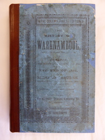 Warrnambool and District Historical Society Inc.
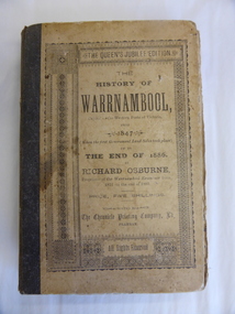
Book, The History of Warrnambool, 1887
This is an original copy of Richard Osburne’s book on the history of Warrnambool from 1847 to 1886. It is a hard cover blue-coloured book of 284 pages with additional Melbourne and Warrnambool advertisements at the end of the book. There is one fold-up insert (four of the original are missing). There are a Preface and Notes From the Author (‘To the public in general’ and ‘To my personal friends in the Warrnambool district’). richard osburne, history of warrnambool, warrnambool history, warrnambool 1886 -
 MYLI My Community Library
Map - Nar Nar Goon County of Mornington Map, 1944, H.E Daw - Government Printer, June 1944
This was a map made in the period before Cardinia shire was created in 1994. With intricate labelling of lot allocations, this map is a invaluable research potential for understanding the settlement of the area and its development in the first half of the 1900s. A paper map with yellow shaded areas and black ink.On Left Side: Pakenham (lot numbers throughout the map) Top side: Gembrook, Tonimbuk Right Side: Bunyip, Koo-wee-rup East Bottom Side: By Authority: / H.E. Daw Government Printer / Melbourne Koo-wee-rup Bottom Right Corner: NOTE: The allotments colored brown are freehold. In respect of which the name. The Area, and the Date where given, are the particulars set out in the Crown grant as issued by the Lands Department. / After the issue of the Crown Grant, all subsequent dealings are effected at the office of titles, Queen Street, Melbourne, and particulars as to present registered ownership, boundaries, subdivisions, etc., may be obtained by search at that office. / This plan has been compiled from the Lands Department Record as at June 1944 / Nar-Nar-Goon / County of Mornington / Drawn and reproduced at the department of lands and survey, Melbourne Price 2/. June 1944 h.e. daw, map, nar-nar-goon, county of mornington, pakenham, koo-wee-rup -
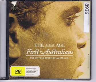 Greensborough Historical Society
Audio - DVD, The Age, First Australians, The Untold Story of Australia, 2008
DVD of First Australian, The Untold Story of Australia. The white settlement of Australia from a first nations perspective. Based on an SBS program.DVD in plastic caseindigenous australians, aborigines, first nations -
 Eltham District Historical Society Inc
Photograph - Digital Photograph, Alan King, Queenstown Cemetery, Smiths Gully Road, St Andrews, 28 December 2007
The discovery of gold in Smyth's Creek in 1854 and subsequent gold rush to the Caledonia diggings led to the establishment of Queenstown (present day St Andrews). The first recorded burial was July 31st, 1861 and it was officially declared a Cemetery Reserve in 1866. Many graves are unmarked and unrecorded including many Chinese and other itinerant miners. The cemetery was closed for new burials in 1851. The last recorded burial was in 1981 in an existing family grave. In Loving memory of David Band Died 30th Decr. 1862, aged 51 years. John Cork Knell Died 11th April 1867, aged 42 years. Eliza Smith Died 20th Jany. 1874, aged 3 1/2 years. William Band Died 20th Feby. 1883, aged 51 years. Published: Nillumbik Now and Then / Marguerite Marshall 2008; photographs Alan King with Marguerite Marshall.; p73 The discovery of gold at Smyth’s Creek* in 1854 brought 3000 people to the area in search of their fortunes.1 However in the harsh conditions many miners and their families died young, and were buried in unmarked graves. Their stories died with them but by 1861, the first burial was recorded at the Queenstown Cemetery – that of William Dalrymple aged 65 – although the cemetery was only officially declared a reserve in 1866. Even before this in 1856, a double burial had been recorded for the twin baby daughters of George Harrison at Market Square, the miners’ settlement – presumably where the cemetery is today. In 1951 the Queenstown Cemetery at 70 Smiths Gully Road, Smiths Gully, closed for burials. However the last burial in a family plot, that of Grace Evelyn Smith, occurred in 1981. Today only 55 headstones remain, but more than 380 burials are recorded. Remnant bushland dominates the cemetery where many graves are merely mounds and others have been damaged by vandalism and the neglect of time. Bushfire in 1962 destroyed the picket fencing, grave markers and cypress boundary planted in the early 1900s. The box/stringybark woodland in the 1.7 hectare Cemetery Reserve is regrowth from then and the indigenous and heritage vegetation is protected. Thanks to the volunteer Cemetery Trust and Friends & Relations of Queenstown Cemetery, the cemetery is maintained, stories recorded and the burial index corrected and expanded.2 Close by the cemetery on the site of today’s Peter Franke Picnic and Nature Reserve stood Market Square, the Caledonia Diggings village of tents and stores, the forerunner of Queenstown, now St Andrews. Many of the Caledonia Diggings miners were Chinese, many of whom, with itinerant prospectors, were buried in unmarked graves. Histories are being recorded of other immigrants, mainly English and German, who settled after the gold rush, some of whose descendants fought and died in the two world wars. Names on many headstones are also recorded on the district’s roads, reserves and war memorials such as Motschall, Joyce, Howard and Coutie. The oldest surviving tombstone is that of Scot, David Band who died in 1862 at 51 years. His oldest daughter Elizabeth, with husband John Knell, owned the Queenstown Hotel and the post office. Child-rearing in a colonial gold town was often tragically difficult, as demonstrated in the first 20 years, when 41% of the 34 burials recorded were children. Settlers endured harsh conditions graphically illustrated with the deaths of Annie Joyce at 30 years and of her family. Annie was married to gold miner Walter Joyce. Their third child Walter, born in 1886, died in March 1887. Eight months later Annie died of breast cancer. Walter died in 1909, aged 53, of miner’s phthisic caused by stone dust destroying his lungs. It was so hard to make a living that burials were usually held from 2.30 pm to allow mourners to work a day before paying their last respects.3 Most burials before 1890 were recorded as Anglicans, as the only church on the Caledonia Diggings was the Church of St Andrew, until 1897, when the Primitive Methodist Church came to Panton Hill. Generally miners came to better themselves, but some, like Grace Hopkinson (nee Milward), born in England in 1828, came from a well-off and educated family. According to family legend Grace emigrated with husband William, to live in a tent, but had kept her personally embossed sterling silver cutlery service. Amid the tough environment were some successes like that reported in The Evelyn Observer April/May 1901 of miner William Hopkinson who was buried at the cemetery in 1912 aged 81. The Observer stated that Hopkinson ‘recently dropped across another find in his claim at One Tree Hill’. The lump of gold found this time weighed more than half a kilo. Mr Hopkinson referred to it as ‘another little speck’. *Today’s Smiths GullyThis collection of almost 130 photos about places and people within the Shire of Nillumbik, an urban and rural municipality in Melbourne's north, contributes to an understanding of the history of the Shire. Published in 2008 immediately prior to the Black Saturday bushfires of February 7, 2009, it documents sites that were impacted, and in some cases destroyed by the fires. It includes photographs taken especially for the publication, creating a unique time capsule representing the Shire in the early 21st century. It remains the most recent comprehenesive publication devoted to the Shire's history connecting local residents to the past. nillumbik now and then (marshall-king) collection, david band, eliza smith, gravestones, john cork knell, queenstown cemetery, smiths gully road, st andrews, william band -
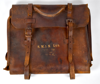 National Wool Museum
Functional object - Brown Leather Satchel Bag, Strachan, Murray and Shannon Ltd, c. 1920s
The company developed from the merchant activities of John Ford Strachan who commenced business in the Port Phillip settlement during 1836. A series of amalgamations from 1876 to 1896 extended the interests of the firm which registered on 23 Dec 1897 as Strachan, Murray & Shannon Pty Ltd. The company floated as a public company on 12 Sep 1919 and changed its name to Strachan & Co Ltd on 1 Jul 1931. The business was taken over by Dennys Lascelles Ltd and deregistered on 2 Aug 1978. The Stachan Woolstore complex on the corner of Moorabool Street and Brougham Street, Geelong was first built in 1840 and has been systematically redesigned over the years. Currently only the facade remains.Brown leather satchel bag with a handle and straps which fasten with metal belt clips. Gold printed lettering is featured on the front. Front [printed]: S. M. & S. LTD. / GEELONG / H. H. H.bag, working life, geelong, leather satchel -
 Eltham District Historical Society Inc
Photograph - Digital Photograph, Alan King, St Margaret's Anglican Church, Pitt Street, Eltham, 30 January 2008
St Margaret’s Church of England was officially opened on December 12, 1861. It is the oldest intact church building in Eltham. At the time it was known as Christ Church until its consecration in 1871, when it was completely free of debt (£1,700 for the church and parsonage) despite the district’s poverty. This was largely due to the free labour and materials, including locally made bricks donated by local artisans and others. The church is historically significant because it is the oldest church in the former Shire of Eltham and has associations with the philanthropist and founder of Brighton, Henry Dendy (who donated the land on which the church is built), the architect Nathaniel Billing and the prominent local builder, George Stebbing. The church is architecturally and aesthetically significant because it is constructed in the Gothic Revival style with several stained-glass windows of various dates and is also a very early use of polychromatic brickwork in Victoria. Billing was one of the first Melbourne architects to employ polychromatic brickwork and an important early architect. The rear wall was intended to be temporary. A major feature of the design is the large buttresses with long, steeply graded upper faces. The overall design is well proportioned with the surface brick patterns relieving an otherwise austere design. The church is spiritually and socially significant because it has been an important place of worship for the people of Eltham for almost 150 years. The land on which the buildings stand was donated by Henry Dendy. Dendy arrived in Melbourne in 1841 after purchasing in England eight square miles at Brighton under the system of "special surveys". After this land passed out of his hands, Dendy moved about Victoria, visited England, then returned to settle in Eltham where he purchased a flour mill. Dendy chaired the meeting held in 1860 “for the purpose of devising such means as may be expedient for the establishment of a Church of England in the township of Eltham”. He became chairman and treasurer of the church committee. Unlike the establishment of many early churches in Victoria where a vicar was appointed to a parish and later a permanent church was constructed, the population at Eltham initiated action to build a church. The nearest church at that time was at Heidelberg and the Eltham settlement was part of the parish of St Johns Heidelberg. Isolation and the tedious, time consuming journey between Heidelberg and Eltham resulted in the Eltham community taking its own action. The original vicarage (Dendy House) at the rear of the church is also an important part of the cultural significance of this place because it is connected to the church and the development of the Eltham area. Together, the church and the vicarage are aesthetically significant because they form a significant streetscape feature. The mud-brick community hall designed by Robert Marshall was added in 1978. In 2014 the original temporary rear wall was removed as part of a modern extension designed by Architects Atelier Wagner and constructed by Conrad Construction and Management. Covered under Heritage Overlay, Nillumbik Planning Scheme. National Trust of Australia (Victoria) State significance Victorian Heritage Published: Nillumbik Now and Then / Marguerite Marshall 2008; photographs Alan King with Marguerite Marshall.; p67 St Margaret’s Anglican Church in Pitt Street, Eltham, which officially opened on December 12, 1861, is the oldest intact church building in Eltham.1 With the nearby courthouse and police station, it was one of the first permanent community buildings in the district. The church and vicarage are on the Register of the Heritage Council of Victoria and the National Trust of Australia – Victoria. The church is important as an early example of polychrome brickwork by the notable architect Nathaniel Billings. It is also notable for its historic associations with the early settlement of the Shire of Eltham and its connection with Henry Dendy, Brighton’s founder.2 Henry Dendy, who lived in Eltham much longer than at Brighton, chaired the original meeting which planned the church, and he donated the half-acre (0.2ha) site. Dendy had arrived in Melbourne in 1841 after buying eight square miles (20.7sq km) at Brighton while in England. After this land passed out of his hands, he eventually settled in Eltham where he bought a flour mill, west from the corner of Main Road and Pitt Street (then called Brewery Lane). The vicarage was named Dendy House after him. The Eltham settlers were unusual in initiating the establishment of a church. Usually in Victoria a vicar was appointed to a parish and then a permanent church was constructed. But then, the nearest church was at Heidelberg, which was a tedious and time-consuming journey. St Margaret’s builder was a local, George Stebbing, who also constructed the former Methodist, later Uniting, Church at John Street and the Shillinglaw Cottage near Eltham’s Central Park. It is believed the first Anglican Bishop of Melbourne, Bishop Perry, dedicated the church. After the ceremony he joined in the festivities at the nearby pub and a bill was sent to the parish for teas taken there by the bishop with other participants. The first vicar was the Reverend Robert Mackie from 1864 to1866. St Margaret’s Church was originally called Christ Church until its consecration in 1871, when it was completely free of debt (£1700 pounds for the church and parsonage) despite the district’s poverty. This was largely due to the free labour and materials, including local bricks, donated by local artisans and others. St Margaret’s Church is in the Gothic Revival tradition with a buttressed nave, paired lancet windows, porch and bell-cote. It was the first polychromatic brick church in Australia, using softly contrasting coloured brickwork.3 Billing was one of the first architects to introduce polychrome brickwork into Melbourne. His original drawings for St Margaret’s survive in a folio of his architectural work. However the church’s brickwork is more subdued than in his drawings. About half the windows – those in clear glass with gold borders – are original. The stained glass windows were made much later, but the one behind the altar is thought to be the oldest in the Diamond Valley. It was to be temporary until the congregation could afford to extend the church. In the early 1960s the original cedar pews were replaced by blonde timber pews and the originals were sold to restaurants and to private individuals. Eminent local sculptor Matcham Skipper created a crucifix for the church. A major addition was made in 1978, when the weatherboard hall was replaced by a mud-brick hall. Made of local material, it was designed by local architect and a former shire president Robert Marshall. The mud-brick hall reflects the style of building in Eltham of the late 1970s and for which Eltham is well-known. Perhaps because its earthy tones blend with the surrounding environment, the hall sits well with the church building. St Margaret’s membership has included economist and ABC chairman, Richard Downing; political commentator, diplomat and academic, William Macmahon Ball; Eltham civic leader, Charles Wingrove; artist, Peter Glass; and Eltham’s first postmaster, Frederick Falkiner.This collection of almost 130 photos about places and people within the Shire of Nillumbik, an urban and rural municipality in Melbourne's north, contributes to an understanding of the history of the Shire. Published in 2008 immediately prior to the Black Saturday bushfires of February 7, 2009, it documents sites that were impacted, and in some cases destroyed by the fires. It includes photographs taken especially for the publication, creating a unique time capsule representing the Shire in the early 21st century. It remains the most recent comprehenesive publication devoted to the Shire's history connecting local residents to the past. nillumbik now and then (marshall-king) collection, eltham, st margaret's anglican church, st margaret's church, st margarets church hall, christ church -
 Eltham District Historical Society Inc
Photograph - Digital Photograph, Marguerite Marshall, St John's Anglican Church, Diamond Creek, 7 September 2008
The building was designed by Charles Maplestone of Heidelberg, son-in-law to Anthony Beale of St Helena. Maplestone was a prominent architect who came out to Australia with his family in 1852. The foundation stone was laid by Mrs Isabella Maplestone on 11th November 1867. The bricklayers for the church were George Stebbing, H Limmer, H Spicer and a Mr Timm while Thomas Day was the stonemason. Another three years were to pass before sufficient money could be raised for its completion. It was opened by Bishop Perry on 1st November, 1870. The church bell which hung under a tree for 50 years until it was incorporated in the parish hall was brought out from England and presented by Charles Orme. In 1916, the estate of George Martin Pizzey left sufficient money to build the red brick hall, which still stands today (2023) though in January 1969 the hall and bell tower were badly damaged by bushfire. Coincidentally the former home of benefactor, George Pizzey was destroyed in the same fire. Of particular significance are the interior and exterior of the church, the Sunday school and hall with emphasis on pre-World War I fabric (excluding the 1990s additions) and the three coloured glass windows currently suspended in the 1990s entry foyer. In 2011 further alterations were made to the front of the Church. The church is historically significant because it was the oldest public building in the former Diamond Valley Shire, is amongst the oldest buildings in the Shire of Nillumbik and is associated with the early settlement of the Diamond Creek district. The church is historically, socially and spiritually significant because it has been a place of worship for over 150 years and continues to be, an important meeting place in the Shire. The church is aesthetically significant for the three stained glass windows executed by the noted stained glass manufacturers, Ferguson & Urie, as well as the supporting coloured glass windows in the church. The Sunday school & parish hall is architecturally significant because the hall is a well executed and preserved example of the work of noted church architects, North & Williams. It is historically significant because it is connected with local parishioner and Melbourne industrialist, George Pizzey, who bequeathed funds for its construction. Covered under Heritage Overlay, Nillumbik Planning Scheme. National Estate Ntionl Trust of Australia (Victoria) Local significance Published: Nillumbik Now and Then / Marguerite Marshall 2008; photographs Alan King with Marguerite Marshall.; p85 St John’s Anglican Church stands like a beacon on the hill on Main Street, Diamond Creek. Today the church has a large congregation, but its early years were marked by a small congregation struggling to find enough money to survive. It was gold in Diamond Creek that resulted in the building of this National Trust registered property.1 This church is far removed from William Wilson’s humble barn (later the Bowling Green) where the first Anglican church services were conducted – probably the first in the district.2 In the mid 19th century services were infrequent as the Rev Francis Hales, travelling on horseback, also conducted services elsewhere, including at Heidelberg, Coburg, Kinglake, Arthurs Creek, St Andrews and Kangaroo Ground. In 1860 Diamond Creek came under the jurisdiction of the Eltham Parish. Until the mid 1860s the Diamond Creek settlement included only about 20 families who were struggling farmers. But this changed when gold was found in 1862. Then the township grew to 200 families, including miners, civil administration workers and shopkeepers. The resulting growth of Church of England adherents prompted them to petition the Government in 1866 for land to build a church. The area chosen, on which the original building still stands, was at the centre of the proposed township. Today church leaders believe that this conspicuous location is one of the reasons for its exceptional growth. Prominent architect Charles Maplestone designed the building as he did the Presbyterian Church at Kangaroo Ground. St John’s, which is still intact, was built in the Gothic Revival style with the traditional rectangular plan of a central nave and sanctuary at the end. It is typical of small churches built in Victoria at that time, with polychromatic hand-made bricks, a porch, diagonal buttresses and a slate roof.3 The church was officially opened by Lord Bishop Perry on November 1, 1870. But during the next 40 years, due to the varying fortunes of gold mining, the church struggled to remain viable. In 1909 it separated from the Eltham Parish to form a parish with Greensborough. Life became more difficult with the privations of World War One. Then disaster struck in 1915 when fire destroyed the Diamond Creek Gold Mine, wiping out the major livelihood of most parishioners. However the church’s morale was lifted in 1916, when it received a bequest to build the red brick hall, from late parishioner and prominent leather manufacturer, George Pizzey. As prosperity grew, in 1924 the congregation separated from Greensborough, but they rejoined in the 1930s Depression. In the 1950s the wider population soared, impacting on St John’s, and it became a separate parish, becoming responsible for six churches at St Andrews, Hazel Glen, Hurstbridge, St Helena and Yarrambat. As parishioner numbers outgrew the building, extensions were added in 1989 and then in 1993, blending in well with the original building. Church members have made a huge contribution to the local community. John Ryan was a Heidelberg Shire Councillor for 25 years from 1931, Mayor in 1939 and headed several local sporting and other organisations. His son Jock became a clergyman and a local historian heading the Nillumbik Historical Society. Another parishioner, Dr Ted Cordner, came to Diamond Creek in 1920. One of his sons Donald, who was a local doctor, won the Brownlow Medal, was President of the Melbourne Cricket Club and President of the Melbourne Grammar School Council. Roy ‘Monty’ Vale was a state Liberal MP and was related to May Vale, a member of the Heidelberg School of Artists.4 In the early 21st century St John’s Anglican Church is one of the fastest growing congregations in Melbourne. References: St Johns Anglican Church complex, Sunday School and Parish Hall 61 Main Street DIAMOND CREEK, NILLUMBIK SHIRE. (2023, June 7). Retrieved from https://vhd.heritagecouncil.vic.gov.au/places/64023 Diamond Creek, VIC. – St John’s Anglican (2023, June 7). Retrieved from https://www.churchhistories.net.au/church-catalog/diamond-creek-vic-st-johns-anglican This collection of almost 130 photos about places and people within the Shire of Nillumbik, an urban and rural municipality in Melbourne's north, contributes to an understanding of the history of the Shire. Published in 2008 immediately prior to the Black Saturday bushfires of February 7, 2009, it documents sites that were impacted, and in some cases destroyed by the fires. It includes photographs taken especially for the publication, creating a unique time capsule representing the Shire in the early 21st century. It remains the most recent comprehenesive publication devoted to the Shire's history connecting local residents to the past. nillumbik now and then (marshall-king) collection, st john's anglican church, diamond creek -
 The Beechworth Burke Museum
Geological specimen - Olivine Crystals, Unknown
... prior to European settlement. Contact was first made between... prior to European settlement. Contact was first made between ...Olivine is mostly found on the Earth's surface in igneous rocks that are dark-coloured. It is common at divergent plate boundaries and at warm spots, such as volcanic areas. It crystalises and forms during the cooling of magma. Olivine is used in refractory sand, bricks, and gemstones. Olivine has been found on a number of meteorites, which might have originated from large asteroids or the mantle of a now-destroyed planet. This olivine crystal is thought to originate from Mount Noorat, with speculation that it could have originated from Mount Shadwell. Mount Noorat is a dormant volcano cone located in the Newer Volcanics Province of Victoria. Mount Noorat belongs to the Kirrae Wuurong people, who used the Mount as a place for meetings and gatherings prior to European settlement. Contact was first made between European settlers and the Indigenous people in 1841. The Mount has mostly been used for cattle and sheep grazing. Mount Shadwell is a well-known source of olivine and is the highest of a gathering of volcanic cones. The New Volcanic Province is located in South East Australia and covers 15000 square kilometres. It contains 400 explosive vents and small shield volcanoes. The last eruption is thought to have occurred 5000 years ago at Mount Gambier and Mount Schank. This olivine crystal has been identified as a volcanic bomb, which is a molten rock which was pushed out and ejected into the air when a volcano reupts. A rock needs to be larger than 65 mm in diameter to be classified as a volcanic bomb. This olivine volcanic bomb and its locality is historically and socially significant. The olivine was found in the Newer Volcanic Province, an area which contains over 400 dormant volcanoes. This olivine is one part of a volcanic bomb, which would have ejected when magma erupted out of a volcano. This specimen is part of a larger collection of geological and mineral specimens collected from around Australia (and some parts of the world) and donated to the Burke Museum between 1868-1880. A large percentage of these specimens were collected in Victoria as part of the Geological Survey of Victoria that begun in 1852 (in response to the Gold Rush) to study and map the geology of Victoria. Collecting geological specimens was an important part of mapping and understanding the scientific makeup of the earth. Many of these specimens were sent to research and collecting organisations across Australia, including the Burke Museum, to educate and encourage further study.A solid iron-magnesium silicate mineral with shades of green and brownburke museum, beechworth, geological, geological specimen, olivine, igneous rock, volcanic, gemstones, volcanic bomb, meteorites, asteroids, plantes, mount noorat, mount shadwell, indigenous, kirrae wuurong people, newer volcanics province, victoria, european settlement, eruption -
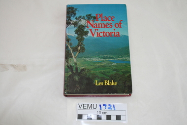 Emerald Museum & Nobelius Heritage Park
Book, Place Names of Victoria, 1977
The sequence of naming was a chronological representative of land discovery and settlement. Starting from the native population to the explorers, the squatters and settlers and surveyors during the gold rush. The term 'places' refers to physical features of the coast and land as well as districts, towns and cities.Hard Cover book written by Les Blake and first published in 1977. The jacket has a photograph of Mount Beauty and the Kiewa Valley from the Tawonga Gap.place names of victoria -
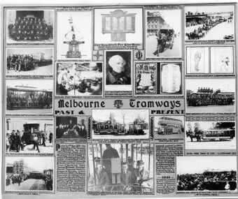 Melbourne Tram Museum
Photograph - Black and White, Melbourne & Metropolitan Tramways Board (MMTB), "Melbourne Tramways Past & Present", 1943
"Melbourne Tramways Past & Present" - set of photos, drawings and notes of (Left to Right, Top to Bottom), Cable tram Richmond Depot employees 1909, Grip mechanism, Photo of the WW1 Honour Board, a horse cab carrying revenue to a bank, Transporting a cable by horse, installing cable to the Windsor line by T Warr & Co 1891, Nicholson St Power House interior, Chief Magistrate of Port Phillip settlement 1836 to 1939 who lived in a house now occupied by Head Office Building, illuminated address to F B Clapp, retirement 1916, drawings by Hal Gye & David Low of J G Roberts Cable Manager, Official & Clerical Staff at Clifton Hill - last line to operate, Depot Employees at Clifton Hill at Final Stage Oct 1940, No. 1 tram becomes Museum piece for National Museum, Australias First Conductresses Aug 1941, Instructor G S Boardman, Decorated peace tram in celebration following armistice 1919, Double deck bus with Conductresses, Royal Park Zoo tram, Openings of PMTT 1910, text box history of the bodies that formed the MMTB, Peter Henry ABC Broadcaster 3-7-1940 on a cable tram, and opening of HTT in 1916. Original poster prepared by the MMTB in 1943 See Reg Item 2854 for a framed photograph and 6367 for another poster of the time - Melbourne tramways past and present poster. See Reg Items 6358, 6122, 6121, 6354 and 6774 for individual photographs.Yields information about the Melbourne tram system and its history to 1943Photograph - of a MMTB Poster titled "Melbourne Tramways Past & Present"tramways, trams, cable trams, richmond, honour board, cash transport, cable ropes, clifton hill, nicholson st, winding house, f b clapp, conductresses, peace tram, double deck buses, zoo horse tram, pmtt, htt, abc -
Merbein District Historical Society
Photograph, Planting the first tree on the Merbein Settlement, 1909
thomas gibson (sir) carmichael -
 Lakes Entrance Historical Society
Photograph - Maringa Creek, 1997c
Walter Seehusan, first art teacher at Bairnsdale School of Mines. Painting in possession of St Nicholas Anglican Church, Lakes Entrance, Victoria, bequeathed by Miss E L Phillips. Original painting 1890c.Colour photograph of a painting by W Seehusan of view from site of Kalimna Jetty towards Nungurner, showing mill workers cottages, jetty and steamers at Maringa Creek sawmill. Fisherman's cottage in right foreground, settlement at Maringa Creek, Gippsland Lakes, by mill workers and fishermen. Painting shows denuded cliffs and timber slide. Lakes Entrance Victoriawaterways, boats and boating, settlement -
 Warrnambool and District Historical Society Inc.
Book, The History of Warrnambool by Richard Osburne, 1887
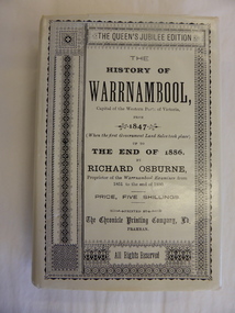
Richard Osburne (1825-1895) came to Warrnambool in 1847, a pioneer resident in the new settlement. In 1851, with John Wilkinson, he founded Warrnambool’s first newspaper, the Warrnambool Examiner, and issued it weekly for some months until he left the town for the goldfields. Returning in 1853 he resumed publication of the Examiner and continued it, intermittently in its last few years, until 1880. He was acknowledged in his day as the Father of the Warrnambool Press and was a dominant figure in Warrnambool’s early history. In 1882 he went to live in Melbourne, returning to publish his ‘History of Warrnambool’ in 1887.This book is highly significant as it is an original copy of one of the most important books written on Warrnambool’s history by one of Warrnambool’s most important early settlers (published 1887). Original copies are extremely rare now. The book was given to D.B. Sellars by his first cousin, John Murray, who was Warrnambool’s Parliamentary representative for over 30 years and Premier of Victoria from 1909 to 1912. John Murray’s signature is in the book and this is an important addition. The provenance therefore is of the highest significance. No details are available on the recipient of the book or the donor of the book to the Historical Society. This is an original copy of Richard Osburne’s book on the history of Warrnambool from 1847 to 1886. It is a hard cover buff-coloured book of 284 pages with additional Melbourne and Warrnambool advertisements at the book. There is one fold-up insert (four of the original missing) There are a Preface and Notes from the Author ('To the public in general’ and ‘To my personal friends in the Warrnambool district’)Inside front cover: Mr D.B. Sellars from John Murray (in pencil – Premier of Victoria 1909-1912, 1st cousin of D.B.Sellars, Uncle David) Donated to the Historical Society of Warrnambool in memory of Miss Clemintine MacDonald of Maffra, who died April 1979, aged 91 years. Given by Mrs M.Allen (niece) 72 Grange Road, Sandringham, 3191, 22-7-80 john murray, richard osburne, history of warrnambool -
 Sunbury Family History and Heritage Society Inc.
Photograph, c1940s
The people in the photograph are outside the Sir John Franklin Hotel which was one of the first hotels to be established in Sunbury in the early days of European settlement along Macedon Street. It continued to operate into the first half of the twentieth century.A non-digital black and white photograph with a cream border. of twenty two people and a dog standing and sitting outside a hotel building.sir john franklin hotel, hotels, sunbury -
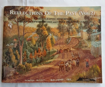 Mont De Lancey
Book, Reflections of the Past (Vol. 2), 2001
Following the success of Volume 1, this follow-up edition is slightly different to the first one by gathering photos together under some new headings More attention is given to some aspects of local history, the pioneer families and community organisations than previously. The historical society's main interest is the history of the Dandenong Ranges and the communities of Belgrave, Tecoma, Upper Ferntree Gully, Upwey and surrounds.A photographic history of Belgrave, Upwey, Tecoma and Upper Ferntree Gully. The front cover is of a painting 'Wintry Sunset Belgrave 1913' from a series of 36 paintings by Charlie Hammond between 1910 and 1953. It is of the country town, Belgrave, showing a dirt road with a bullock team, with trees surrounding the road. Inside, are black and white and coloured photographs of paintings, people in general life and historical information about the areas noted. Pp.104.non-fictionFollowing the success of Volume 1, this follow-up edition is slightly different to the first one by gathering photos together under some new headings More attention is given to some aspects of local history, the pioneer families and community organisations than previously. The historical society's main interest is the history of the Dandenong Ranges and the communities of Belgrave, Tecoma, Upper Ferntree Gully, Upwey and surrounds. australian history, history of the dandenong ranges victoria, history victoria -
 Warrnambool and District Historical Society Inc.
Book, The History of Warrnambool by Richard Osburne, 1980
Richard Osburne (1825-1895) came to Warrnambool in 1847, a pioneer resident in the new settlement. In 1851, with John Wilkinson, he founded Warrnambool’s first newspaper, the Warrnambool Examiner, and issued it weekly for some months until he left the town for the goldfields. Returning in 1853 he resumed publication of the Examiner and continued it, intermittently in its last few years, until 1880. He was acknowledged in his day as the Father of the Warrnambool Press and was a dominant figure in Warrnambool’s early history. He was associated with the establishment of the Aboriginal Reserves, Fire Brigade, Mechanics’ Institute, Warrnambool Council, National School, Presbyterian Church, Public Wants Committee, Villiers Building Society, Fish Protection Society, Dramatic Club, Cricket Club, Otway Gold Exploration Syndicate and other institutions. In 1882 he went to live in Melbourne, returning to publish his ‘History of Warrnambool’ in 1887, a Queen’s Jubilee publication. Richard Osburne’s book is a seminal work of the 19th century history of Warrnambool and its importance cannot be over-emphasized. The original copies of this book are now hard to get and are very valuable. This facsimile is kept because the facsimiles are also now becoming rare and they are good examples of the way a facsimile is reproduced and the reason for the existence of this particular reprint– the importance and usefulness of Osburne’s history and the need to make it accessible to researchers today.This is a facsimile edition (1980) of Richard Osburne's book on the history of Warrnambool from 1847 to 1886. It is a hard cover buff-coloured book with gold lettering on the spine. The dust cover is cream-coloured paper with black writing. Inside the cover is a map of southwest Victoria (1880). There are five fold-up inserts (sketches, diagrams etc), a number of business advertisements, sepia photographs and sketches and an index. The dust cover includes information on the author. There are 25 chapters, a foreword by the Prime Minister of Australia, Malcolm Fraser and a Preface The proceeds of the book reprint went to Flagstaff Hill Maritime Village.This is a facsimile edition (1980) of Richard Osburne’s book on the history of Warrnambool from 1847 to 1886. It is a hard cover buff-coloured book with gold lettering on the spine. The dust cover is cream–coloured paper with black writing. Inside the cover is a map of southwest Victoria (1880). There are five fold-up inserts (sketches, diagrams etc), a number of business advertisements, sepia photographs and sketches and an index. The dust cover includes information on the author. There are 25 chapters, a foreword by the Prime Minister of Australia, Malcolm Fraser and a Preface The proceeds of the book reprint went to Flagstaff Hill Maritime Village.richard osburne, the history of warrnambool, warrnambool examiner -
 Warrnambool and District Historical Society Inc.
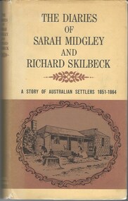
Book, The Diaries of Sarah Midgley and Richard Skilbeck, 1967
Pioneer diaries of early Australian settlers, Sarah Midgley and Richard Skilbeck.Tan hard covered book with tan and yellow dust jacket. Title and text is black. Front cover has framed drawing of cottage taken from photograph which is included in the book. Map of area is on inside front and back covers.208 pages. It has a number of black and white photographic plates included.non-fictionPioneer diaries of early Australian settlers, Sarah Midgley and Richard Skilbeck.sarah midgley, richard skilbeck, diaries of sarah midgley and richard skilbeck, yangery, early pioneer life, wesleyan church warrnambool, yangery koroit -
 Warrnambool and District Historical Society Inc.
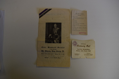
Memorabilia - Two articles of civic events in Warrnambool, Kaye & Son, Warrnambool Printers, mid 20th century
The card relates to the Official Centenary Ball held in the Warrnambool Town Hall in March 1947 to celebrate the city's Centenary in 1947. Warrnambool was founded as a port settlement to service the farming interests in the area, with the first land sales held in Melbourne in July 1847. The leaflet is a programme of the Civic Memorial Service held in the Botanic Gardens in Warrnambool in February1952 on the occasion of the death of King George VI of England. Both items came from memorabilia held by the Bamford family of 8 Monash Avenue Warrnambool and it is presumed that one or more members of that family attended the events.These items are of social significance as mementos of events in Warrnambool in the mid 20th century..1 A white card with black printing and a logo .2 A sheet of white paper folded to make four pages with black printing and a photograph of King George VI of Englandwarrnambool memorabilia, warrnambool centenary, warrnambool centenary 1947, official centenary ball. -
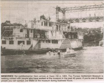 Bendigo Historical Society Inc.
Newspaper - JENNY FOLEY COLLECTION: MEMORIES
The paddle steamer "Gem was first launched in 1876 as a passenger and cargo mode of transport on the Murray River. In the '30's and '40's it operated as a tourist passenger boat. In 1948 it sunk in 15 feet of water but was repaired and refloated. It was retired in 1950. In 1962 it was sold to the Swan Hill pioneer Settlement. The Swan Hill Folk Museum was Australia's first open air museum and opened to the public in 1966, It was renamed the Pioneer Settlement.Bendigo Advertiser ''The way we were'' from 2003. Memories: the paddle steamer Gem arrives at Swan Hill in 1963. the pioneer Settlement Museum is seeking contact with people who have worked at the museum in the past 40 years. The clip is in a folder.newspaper, bendigo advertiser, the way we were -
 Buninyong & District Historical Society
Photograph - Colour Photograph of side of Mount Boninyong Homestead 1991, Sideview of Mount Boninyong Homestead
The homestead was built in 1884 by Robert Scott in Scottish Baronial StyleThe original station of 16,000 acres was taken up in 1839 by Andrew Scott and Mrs. Scott was reputedly the first European woman in the districtSideview of Mount Boninyong Homesteadearly settlement, mount buninyong, scott family -
 Buninyong & District Historical Society
Photograph - Black and White Photograph of Mount Boninyong Homestead 1991, View of croquet lawn Mount Boninyong Homestead 1991
The homestead was built in 1884 by Robert Scott in Scottish Baronial StyleThe original station of 16,000 acres was taken up in 1839 by Andrew Scott and Mrs. Scott was reputedly the first European woman in the districtView of croquet lawn at Mount Boninyong homestead part of the main house is visible in the backgroundearly settlement, mount buninyong, scott family -
 Stawell Historical Society Inc
Photograph, Great Western 1866
Great Western. Part of a collection of Photographs by Mr. O.G. Armstrong as commissioned by the Shire of Stawell for the Inter-colonial and Paris Exhibition in Melbourne in 1866. Great Western began as a changing station on Concongella, northeast of the present Township. The gold rush in Great Western began in 1858 and soon after a post office and store opened. A Township was surveyed and lots sold in October 1858. The gold soon passed and the diggers went on, leaving a small settlement. In 1863 Jean Pierre Trouette and Emile Bampied, his brother-in-law, planted the first vines and build the first winery, thus setting a firm foundation upon which the present wine industry has been built. Telegraph poles and wires visible. Bakery visible in distance on right of road, looking west. stawell -
 Warrnambool and District Historical Society Inc.
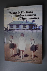
Book, From tents & tin huts to timber houses & tiger snakes: Soldier Settler stories from Hawkesdale, Macarthur & Penshurst, April 2021
Soldier settler family stories from the Hawkesdale, Macarthur and Penshurst areas.A4 soft bound book with photograph of timber house in country location with post and wire fence and three children walking towards the house; a girl in light-coloured dress carrying a school case is in the middle with a boy in crossover top shorts with school bag over their right shoulders on either side of her. Text is black.non-fictionSoldier settler family stories from the Hawkesdale, Macarthur and Penshurst areas.military history, soldier settlement wwii, hawkesdale, macarthur, penshurst, eugene von guerard, robert dowling, first australians -
Lakes Entrance Historical Society
Book, Thomas, Krystyna M, Bunga Haven, 2013
A story of Bunga Haven, East Gippsland from the first occupation in 1885 to its present use as a peaceful retreat for members of Bung Haven Cooperative. Through extensive research, interviews with descendants of the original settlers, inclusion of anecdoTo Lakes Entrance Historical Society with best wishes. Krystyna Thomassettlement -
Lakes Entrance Historical Society
Book, LERHS, The First Years of Lakes Entrance, 1995c
Folder containing photocopies extracts from the Bairnsdale Advertiser 1960c subtitled Our Province in the Making plus extracts from Lakes Post newspaper 1990c titled The History of Lakes Entrance Victoriasettlement, transport, agriculture, waterways -
Mont De Lancey
Photograph - Family Photograph, Anker Family, 1886
This photograph pictures the Ankers, one of the founding families of Wandin, Victoria, Australia. It shows the first home they built on their "Tooroonga Park" property, significantly one of the first waves of home in Wandin. It was provided to the Wandin Historical Society and serves as part of Mont de Lancey's extensive digital and physical records of early regional family histories and the history of Victorian settlement.Small A5 black and white photograph of Anker family. Features six adults in 1880s dress. From left to right: Selina Anker (daughter) in long sleeve dark dress, William Anker (father) in slacks and a dark hat, William Anker (son) in dark button up jacket, Emily Anker (daughter) in long sleeve dark dress, Ernest Anker (son) in light button up shirt with tie, and Emma Anker (mother) in patterned dress with skirt ruffles and trumpet sleeves. They stand in front of a light wood house with a brick chimney, surrounded by plants. On the back of the photo is an inscription describing the people and place pictured written by a researcher.ORIGINAL HOME BUILT ON "TOOROONGA PARK" PROPERTY / IN 1886. 55 QUAYLE ROAD WANDIN. / WILLIAM (WILLHEIM) AND EMMA ANKER (nee'HAND)Lilydale. / ELDEST OF THEIR 5 CHILDREN ELIZABETH WORKING AWAY. / Left: SELINA, WILLIAM (Father) WILLIAM (son),EMILY,ERNEST, / EMMA (Mother).tooroonga park, wandin, family photograph, anker family, historical homes, victorian history, regional victoria, farming settlements, yarra valley -
Lakes Entrance Historical Society
Book, Judy Hartley, Nowa Nowa A Journey through the First 100 Years, 2018
A collection of photographs facts and history from the proclamation of the settlement and township in the Victorian Gazette of December 1888 until becoming the thriving community in 1988 Nowa Nowa East Gippsland Victoriatownship, timber industry, railways -
Lakes Entrance Historical Society
Book, Una Smith, Australia The First Hundred Years, 1976
A facsimile of volumes 1 and 2 of the picturesque atlas of Australia 1888 including short account of Australia as a penal settlement and establishment of separate states Victoriasettlement, exploration, australia -
Lakes Entrance Historical Society
Book - Arthur Phillip, Hughes, Thea Stanley, 1982
An account of the life and achievements of Arthur Phillip, commander of the First Fleet, sent to Botany Bay; the relocation to Port Jackson, and the development of the settlement under his governorship. Written for students.An account of the life and achievements of Arthur Phillip, commander of the First Fleet, sent to Botany Bay; the relocation to Port Jackson, and the development of the settlement under his governorship. Written for students.law, government, land settlement