Showing 355 items
matching gardening
-
 Mont De Lancey
Tool - Drainage Shovel, Unknown
Used by Wandin Sebire for an unknown purpose.A narrow goose necked drainage shovel with a very long wooden handle which was used to clean urban drains and prepare trenches for narrow pipes. A goose necked shovel is pulled towards the user by the very long handle. Used in the early 20th century.shovels, gardening tools, gardening equipment, tools, spades -
Mont De Lancey
Tool - Drainage Shovel, Unknown
A long swan necked steel scooped drainage shovel head with a long wooden handle, attached to the head by three rivets. It was used to prepare trenches for narrow pipe drains. A swan necked shovel is pushed away from the user by the very long handle. Used in the early 20th century.shovels, gardening tools, gardening equipment, tools, spades -
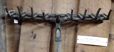 Mont De Lancey
Tool - Scarifier
An adjustable metal headed hand scarifier with a wooden handle attached with a screw. It has nine teeth with the middle one lower, fixed and wider. It could be altered to suit the width of the row being worked. It was patented 1905.Patented 1905agricultural tools, agricultural equipment, tools, rakes, scarifiers, gardening tools, hand tools -
 Mont De Lancey
Tool - Scarifier, Unknown
A small combined hoe and rake metal headed hand scarifier or cultivator tool with a wooden handle. It has a pointed hoe shape at one end and at the opposite two hooked spikes. It could be used in small areas such as a garden.agricultural tools, tools, rakes, scarifiers, gardening tools, hand tools, hoes -
 Mont De Lancey
Tool - Hoe, Rake Head, Unknown
A small forged steel combined hoe and rake head hand cultivator tool. It has one flattened hoe shaped edge at one end and at the opposite, three rake prongs, and there is an extension on the head for the wooden handle to be attached. It could have been used in small areas such as a garden in the 19th century..agricultural tools, tools, rakes, gardening tools, hand tools, hoes -
 Mont De Lancey
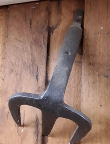
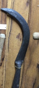
Tool, A & F PARKES & CO, Slasher, Unknown
A metal King Eye slasher with an unusual rounded 'U' shaped open blade and a wooden handle. On the blade is stamped, 'King Eye, PATT NO, 3868 A & F PARKES & CO BIRMINGHAM England'. It was efficient for clearing thin and dense low-lying scrub or bush where an axe would be too clumsy. It is similar to a billhook, but with a longer handle.'KING EYE, PATT NO, 3868 A & F PARKES & CO BIRMINGHAM ENGLAND'tools, agricultural equipment, agricultural tools, slashers, gardening tools -
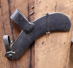 Mont De Lancey
Tool, Slasher, Unknown
Used by Wandin T Sebire.A thick curved forged steel scrub slasher - head only. It has two bent steel clamps to attach a handle, one which is small and is attached by a screw, the other large one is attached by two rivets. It was efficient for clearing thin and dense low-lying scrub or bush where an axe would be too clumsy. tools, agricultural equipment, agricultural tools, slashers, gardening tools -
 Mont De Lancey
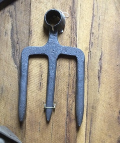
Tool - Fork Hoe, Unknown
A thick forged steel three pronged fork hoe head made by a blacksmith. There is a bent extension piece at the fork head where a handle can be attached.agricultural tools, gardening tools, hoes, gardening forks, handtools -
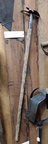
 Mont De Lancey
Tool - Bush Rake, Unknown
Used circa 1890.A blacksmith handmade bush rake with a steel head and a handmade long wooden handle which was roughly hewn from tea-tree wood. The head with 11 prongs is attached to the handle by a fork shaped steel fitted extension with three rivets. It was used to rake up debris after clearing land circa 1890.gardening tools, gardening rakes, rakes, gardening equipment, domestic equipment, tools -
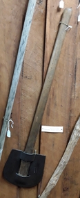
 Mont De Lancey
Tool - Hay Fork, Unknown
Used late 19th and early 20th centuries.A blacksmith handmade hay fork or pitch fork with three thin forked metal spikes and a handmade long wooden handle. The head is attached to the handle with two rivets. It was used in the late 19th century and early 20th century.gardening tools, gardening equipment, domestic equipment, tools, gardening forks, pitchforks, agricultural equipment -
 Mont De Lancey
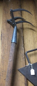
Tool - Scarifier, Unknown
It was used on well worked ground.A combined hoe and rake metal headed hand scarifier or cultivator tool with a long wooden handle. It has three curved metal hooks with sharp points and was used to break up the ground. It could be used in small areas such as a garden.agricultural tools, tools, rakes, scarifiers, gardening tools, hand tools, hoes -
 Mont De Lancey
Tool - Fork Hoe, Unknown
A thick forged steel three pronged fork hoe head made by a blacksmith. There is a hole at the fork head where a handle can be attached.agricultural tools, gardening tools, hoes, gardening forks, handtools -
 Mont De Lancey
Tool, Slasher, Unknown
A handmade slasher with a long wooden handle and a heavy sharp steel blade attached with a rivet to the handle. It was efficient for clearing thin and dense low-lying scrub or bush where an axe would be too clumsy. Indiscernable inscriptiontools, agricultural equipment, agricultural tools, slashers, gardening tools -
 Mont De Lancey
Tool, Slasher, Unknown
A hand slasher with a long wooden handle and a heavy sharp steel rectangular blade attached with rivets to the handle. It was efficient for clearing thin and dense low-lying scrub, ferns or bush where an axe would be too clumsy. '232205' is stamped on the flat blade but the writing is Indiscernible. tools, agricultural equipment, agricultural tools, slashers, gardening tools -
 City of Kingston
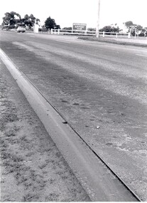
Photograph - Black and white, c. 1970
This photograph depicts the steel tramway (or tram plate) along Centre Dandenong Road, Cheltenham near the Moorabbin Airport entrance in the 1970's. These tramways played an important role in transportation along Moorabbin's major roads. Heavily laden carts could travel smoothly and safely along the steel plates when the road surfaces were often rutted and hazardous. This surviving section was later moved for road improvements. The area now known as the City of Kingston was a market garden region and the round trip to market could take as long as eight hours on poorly maintained roads. The installation of the steel tramway transformed the arduous journey faced by market gardeners in transporting their produce to market. As there was only a single tramway, the carts often travelled in convoy, enabling drivers to leave piloting to the first cart and having a rest. The rails did not speed the journey to the city, but it smoothed progress immeasurably. Black and white photograph of steel tram plates on Centre Dandenong Road, Cheltenham. The road is sealed. At the top of the image there are trees behind a parked car which is adjacent to a white shelter. There is a large sign stating MOORABBIN AIRPORT above an arrow pointing to the right in the top centre of the image. Handwritten in pencil: A 28 / [indecipherable] 3 / [indecipherable] Handwritten in red ink: A28 / 70%market gardening, infrastructure, transport, steel tramway, industry, moorabbin -
 City of Kingston
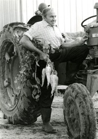
Photograph - Black and white, Moorabbin News, 1963
Francis (Frank) Wilbur Le Page was mayor of Moorabbin between 1980 - 1981, and again in 1984 - 1985. He was a lifelong resident of the region and also a third generation market gardener.In approximately 1854, Nicholas Le Page moved his family from Prahran to Cheltenham. Two years earlier, they had arrived in Melbourne from Guernsey Island. Nicholas Le Page was a tailor and his wife was a dressmaker. They decided to move into market gardening instead. Their son, Everest, married Lynda and Francis Wilbur Le Page was born in 1919. He attended Cheltenham State School where he completed his Merit Certificate in grade eight before studying bookkeeping, shorthand and typing at Bradshaw and Everett Business College in South Melbourne. Both Frank’s grandfather and father were active in local government. Francis Thomas Le Page was a councillor for 25 years and served a term as shire president in 1902. Everest, his son, was a councillor for the City of Moorabbin for 28 years and was mayor on two occasions. Frank also served two terms as mayor, first in 1980 and again in 1984. Frank died on 14 July 2008.Black and white photograph of Frank Le Page stepping down from a tractor, with a bunch of parsnips in his right hand.Pink coloured paper adhered to reverse with black printed text and handwritten text in blue ink: STANDARD NEWS / Paper MOOR / Catchline Garden / Percentage 88% / Date 17-10-84 / Page 23le page, market gardens, tractor, moorabbin -
 City of Kingston
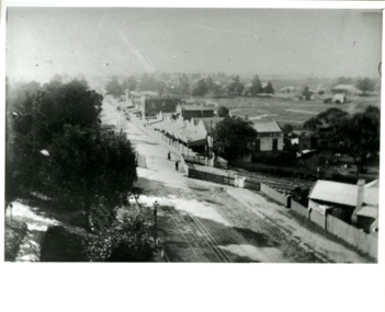
Photograph - Black and white, Percy Fairlam, c. 1910
Black and white image of Cheltenham in the early 20th Century depicts an almost idyllic life. This photo was taken by Percy Fairlam, who climbed a tall pine tree to achieve the aerial view. The tree was a well recognised feature of the Cheltenham skyline but was cut down some time before World War II.Cheltenham was established as a rural market gardening community. The development of the railway was crucial to the ongoing development of the area. Community life sprung up around the railway line which is evident in the proximity of shopping and leisure.Black and white image depicting aerial view down Charman Road, Cheltenham, including the unsealed road, level crossing and shopping centre. What appears to be a cricket pitch is located behind the shops.Handwritten in black ink on a red round sticker adhered to the reverse, and then crossed out: X14 Handwritten in blue ink on reverse: A8 Handwritten in red ink on reverse: 85%cheltenham, railway crossing, roads, housing, shopping strip -
 City of Kingston
Photograph - Black and white, 20 December 1945
This aerial photograph depicts the changing landscape of Cheltenham and Highett since WWII. Photographed in 1945, there is a mix of urban dwellings and industrial development and precedes the major transformation of Cheltenham with the development of the Southland shopping centre in the 1960s and expansion in the 1990s.A large part of Cheltenham was originally established as a rural market gardening community. The railway line and station brought urban development to the area and in the north, the Highett area was dominated by the Highett Gas Works. Cheltenham became a major destination for shopping in the 1960s with the opening of Southland.Aerial photograph taken in 1945 of Cheltenham and Highett within the City of Kingston. The image includes the Highett Reserve, (top right), the Methodist Children Homes (now Southland), Nepean Highway and Jamieson Street. Highett Gas Works is visible in the top left and the land now named William Fry Reserve at the intersection of Bay Road and Nepean Highway. A visible large parcel of land on the corner of Bay Road and Nepean Highway was developed in the 1990s as the west side addition to Southland. The densely vegetated area in the upper right sector of the image is now dense with housing. Tulip Grove, Heather Grove and Gilford Street are visible bottom left. This image is possibly from the collection of aerial photographs commissioned by the Department of Crown Lands and Survey and taken by Adastra Airways.Black ink: 57252 White lettering: VIC-10 57252 20.12.45 [lens information indecipherable] PROJ. No.5 MELB. METROP AREA Black pencil: 80highett, cheltenham, highett gas works, urbanisation -
 City of Kingston
Photograph - Black and white, 20 December 1945
This aerial photograph depicts the changing landscape of Cheltenham and Highett since WWII. Photographed in 1945, there is a mix of urban dwellings and industrial development and precedes the major transformation of Cheltenham with the development of the Southland shopping centre in the 1960s and expansion in the 1990s.A large part of Cheltenham was originally established as a rural market gardening community. The railway line and station brought urban development to the area and in the north, the Highett area was dominated by the Highett Gas Works. Cheltenham became a major destination for shopping in the 1960s with the opening of Southland.Aerial photograph taken in 1945 of Cheltenham and Highett within the City of Kingston. The image includes the Highett Reserve, (top right), the Methodist Children Homes (now Southland), Nepean Highway and Jamieson Street. Highett Gas Works is visible in the top left and the land now named William Fry Reserve at the intersection of Bay Road and Nepean Highway. A visible large parcel of land on the corner of Bay Road and Nepean Highway was developed in the 1990s as the west side addition to Southland. The densely vegetated area in the upper right sector of the image is now dense with housing. Tulip Grove, Heather Grove and Gilford Street are visible bottom left. This image is possibly from the collection of aerial photographs commissioned by the Department of Crown Lands and Survey and taken by Adastra Airways.Black type: Reverse lettering VIC-10 57252 20.12.45 [lens information indecipherable] PROJ. No.5 MELB. METROP AREA White lettering: Reverse writing 57252cheltenham, highett, highett gas works, urbanisation -
City of Kingston
Photograph - Black and white, 20 December 1945
This photograph depicts a section of Cheltenham with a mix of housing and market gardens. The visible market gardens, farms and paddocks have gradually been sub-divided into housing, commercial and industrial estates. A large part of Cheltenham was originally established as a rural market gardening community. The railway line and station brought urban development to the area and the gradual subdivision of farmland and large land holdings for the development of housing. Aerial photograph dated 1945 of the Cheltenham area in the City of Kingston. Sydney Street (bottom left); Sinclair Street (top left); Weymar Street area off Wilson Street, Charles Street (botton right).White print VIC-170; 57197; RUN5; PROJ.No.5; MELB.METROP AREA Lens information [indecipherable] Small photograph: clockface Black ink: 57197cheltenham, market gardens, urbanisation -
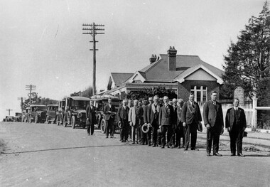 City of Kingston
Photograph - Black and white, Funeral procession of Francis Thomas Le Page, 1927
Funeral procession of Francis Thomas Le Page leaving Church of Christ, Chesterville Road, Cheltenham. Minister of church lead procession followed by members of the Star of Moorabbin Order of the Sons of Temperance Friendly Society wearing broad collars. F.T. Le Page was a councillor for 25 years and served as president of the Shire of Moorabbin in 1902/3. He died on 12 December 1927.Nicholas and Rachel (nee Addy) Le Page migrated from Geurnsey to Australia in 1852 with their young son Francis, who was less than a year old. They first lived in Prahran, setting up their own business and after about two years decided to move to Cheltenham and take up market gardening. The Le Page family has been associated with region ever since and have taken on many roles of prominence including local politics. Black and white image of a group of men, standing in two lines, all with hats off. They are standing in front of a line of cars. The first car in the line appears to have flowers on the roof which possibly indicates it is carrying the coffin in this funeral procession. -
 University of Melbourne, Burnley Campus Archives
Newspaper - Newspaper Cutting, The Australian Garden Lover, The Burnley Gardens, October 1926
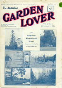
On cover pages are 6 photographs of Burnley College and the heading "An Australian Horticultural School Enterprise at Burnley,Vic". The 4 photos on the lower half of the cover page were used in "Green Grows Our Garden", by A.P Winzenreid, Hyland House (1991) p. 52. A.P Winzenreid described the photos as: Top left (photo 3): Espaliered fruit tree on fence, established and trained by George Russ and continued as a feature of interest into the 1950s. Located in old nursery area. Top right (photo 4): orchard spraying. Bottom left (photo 5): View of pavilion. Note Luffmann's pond and Pinus radiata planted in 1860s and removed by G. Manley and A. Tylee (1951-53). Bottom right (photo 6): A.W. Jessep (principal) and E.E. Pescott (lecturer) outside Principal's residence. (Photos 1 and 2 on the cover of the Garden Lover were not reproduced in "Green Grows Our Garden". The Australian Garden Lover, vol. 2 no. 7, October 1, 1926, p 266-7. Cover and two pages.the australian garden lover, green grows our garden, a.p. winzenreid, george russ, espaliered pear, old nursery, orchard, spraying, pavilion, ponds, pinus radiata, a. w. jessep, e. e. pescott, principal's residence, gardening publication, horticulture newspaper, 20s gardening -
University of Melbourne, Burnley Campus Archives
Book - Reference Book, A. G. Kennelly, The Home Vegetable Garden, 1958
Book with light cardboard cover. Bulletin No. 342 New Zealand Department of Agriculture 1958 by A. G. Kennelly, Vegetable Instructor, Department of Agriculture, Dunedin. Contains general information about vegetable growing and vegetables are listed alphabetically.vegetables, vegetable growing, new zealand, home gardening -
University of Melbourne, Burnley Campus Archives
Book, Royal Horticultural Society, The Vegetable Garden Displayed, 1959
Book with light cardboard cover. Produced by the Royal Horticultural Society, London. Eleventh Impression 365th thousand, 1949. Very detailed descriptions of how to plant out gardens or allotments. Individual vegetables described. Photographs from Wisley, Surrey.vegetables, vegetable growing, home gardening, royal horticultural society, allotments, wisley -
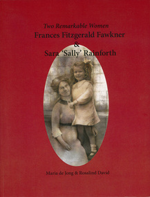 Narre Warren and District Family History Group
Book, Rosalind David et al, Two remarkable women : Frances Fitzgerald Fawkner & Sara 'Sally' Rainforth, 2013
"Melbourne in the 1890s - women can't vote and unmarried mothers are social outcasts. Frances, a young journalist, believes in equal rights for women and their right to have children outside of wedlock. In 1905, pregnant and alone, she boards a steamship for London. Closely intertwined with the lives of Frances and her daughter Sally are the lives of Frances' best friend Ethel and her husband, author Charles Chomley ... As an adult in rural Wales, Frances' daughter Sally must learn to reconcile the past, her origins, and the loss of loves ones. Gardening becomes her passion. This intriguing double biography shows how women's lives are shaped by society's expectations and how social norms have changed. The book follows the lives of two strong women - Frances Fitzgerald Fawkner and Sara 'Sally' Rainforth"--Back cover.177 p.non-fiction"Melbourne in the 1890s - women can't vote and unmarried mothers are social outcasts. Frances, a young journalist, believes in equal rights for women and their right to have children outside of wedlock. In 1905, pregnant and alone, she boards a steamship for London. Closely intertwined with the lives of Frances and her daughter Sally are the lives of Frances' best friend Ethel and her husband, author Charles Chomley ... As an adult in rural Wales, Frances' daughter Sally must learn to reconcile the past, her origins, and the loss of loves ones. Gardening becomes her passion. This intriguing double biography shows how women's lives are shaped by society's expectations and how social norms have changed. The book follows the lives of two strong women - Frances Fitzgerald Fawkner and Sara 'Sally' Rainforth"--Back cover.berwick (vic.), frances elmes, frances fitzgerald fawkner, sara 'sally' rainforth, charles chomley, ethel a'beckett, dr thomas elmes