Showing 359 items matching "geological society"
-
 Bendigo Historical Society Inc.
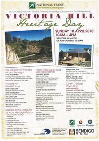
Document - VICTORIA HILL MARONG RD BENDIGO HERITAGE DAY BROCHURE 2010, 2010
Victoria Hill Marong Rd Bendigo (Opposite the Gold Mines Hotel) Heritage Day Brochure 2010. Victoria Hill Guided Tours James Lerk (Bendigo Historical Society) George Ellis (Bendigo Cornish Association) Rod Orr (Bendigo Field Naturalists Club) David Bannear (Heritage Victoria) Presentations: Rod Fraser The Geology of Victoria Hill and Bendigo, Kurt Walder German Heritage Ballerstedts-miners from the Hartz Mountains crushing battery, Rod Orr Mining and the Environment in Bendigo, Michele Matthews (BRAC) Sir John Quick the Forgotten Father of Federation spent his youth in the shadow of Victoria Hill, David Bannear ''Things Forgotten'' - the Archaelogy of Bendigo, Carol Holsworth the Chinese and Victoria Hill area, John Kelly Inquests held at the Gold Mines Hotel, George Ellis The Cornish miners of the Ironbark and Long Gully area, Amanda Jean The Ironbark Heritage Study. Coath Cottage Open Day owner Andrew Ward and Restorer Gary Hill explain the history and restoration of the 1860s miners cottage after Black Saturday fire. Restoration Loans from the City of Greater Bendigo.bendigo, gold mining, heritage day 2010 -
 Bendigo Historical Society Inc.
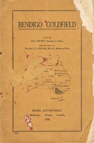
Book - JOAN O'SHEA COLLECTION: BENDIGO GOLDFIELD BOOK, 1936
Joan O'Shea collection. Buff coloured book issued by Mines Department Melbourne. Victoria Australia 1936. Information contained within refers to History, Recent developments and future Prospects, Geology, Lines of Reef for the Bendigo area, information regarding tonnage of gold and values of same at that time. The index at the rear of the book lists all of the mines in the Bendigo area.Geo. Brown, Secretary for Mines, Mines Departmentmining, business, mines department -
 Bendigo Historical Society Inc.
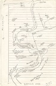
Document - PETER ELLIS COLLECTION: SKETCH OF THE BARFOLD GORGE
Two photocopies of hand-drawn sketch of the Barfold Gorge. On the sketch is the location of a house, trees, fences, different types of rock, some accessible areas to get down to the river, geological features and water falls.place, land, barfold gorge, peter ellis collection, barfold area, mitchell's falls, queen's fall -
 Bendigo Historical Society Inc.
Document - PETER ELLIS COLLECTION: NOTES MENTIONING WHIPSTICK REGION
Four pages of typed notes mentioning the Whipstick Region, Mandurang Forest, Jackass Flat, Diamond Hill Area, One Tree Hill, and the Coliban/Sandhurst Water Supply Reserve. Mentioned are the Birds, Mammals, Geology, Flora, Ground Flora, Orchids,Lilies, Mistletoe, Ferns and Grasses of some of the areas.bendigo, parks and gardens, public reserves, peter ellis collection, north/central l.c.c. region bendigo block, bendigo field naturalists club, shipstick scrub, mandurang forest, one tree hill public park, redvers j eddy, coliban/sandhurst water supply reserve -
 Bendigo Historical Society Inc.
Document - PETER ELLIS COLLECTION: NOTES WRITTEN BY PETER ELLIS
Some brief research? Notes written by Peter Ellis from the years 1881 to 1899. Mentioned is the Bendigo School of Mines Science Society and some of its meetings and the number of people who attended. Also mentioned are: The animal of Australia by Dr. MacGillivray; a paper on graptolite by Mr T L Hall, M.A., Director of Castlemaine School of Mines; Annual Report June 30 1888, Spiders, ? & Marsupials (MacGillivray/Rev Williams; Nancarrow - Slides & Cross Courses - Geological quartz of Goldfield; 27/1/1887 Meetings held during the year - some were well attended, some were not; On the 31 May the President (MacGillivray) spoke at some length on the Requirement of a Local Museum; Annual report 1900; Mining Society formed 1899 and Scientific Conversation lecturettes on Chemistry & Electricity.bendigo, history, early bendigo, peter ellis collection, the a-- of australia, dr macgillivray, t l hall ma, castlemaine school of mines, bendigo school of mines science society, rev williams, nancarrow, sandhurst district, requirements of a local museum, melb public library -
 Bendigo Historical Society Inc.
Journal - Dicker's Mining Journal 1862
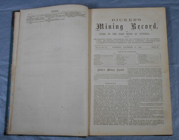
Thomas Dicker, Rowan Street, Bendigo, published a monthly mining journal that included geological information, mine details and mining practises for particular mining districts. In 1868/9, Dicker moved to England to open the "Australian and London Mining Agency" with the goals of promoting investment in Victorian mines, entering Victorian mining shares on the London Stock market, and exploring the latest in mining technology that might be suitable for mining in Victoria.Dicker's Mining Record and guide to the gold mines of Victoria, showing the bearings, depths, thickness, dips and underlies of the auriferous lodes; the progress and cost of works in operation; containing also a variety of valuable interesting and statistical information. Published by the proprietor, Thomas Dicker, Rowan Street Sandhurst. A green with black spine hardcover book. Paper glued on the front with the title Dicker's Mining Journal 1862. On the spine in gold lettering Dicker's Mining Record Vol.1 1861-2. The book contains 12 issues of the Dicker's Mining Record, the first from Saturday, November 23, 1861: the last from October 24, 1862. Also, there are two pieces of paper inside front cover with writing in pencil; the first says: shaft originally No.3 shaft of the speedwell coy. in 1902 the North Normanby Coy. was formed and took over the shaft. A new winding engine was installed in 1909. 10 head battery 1905, extra 20 head in 1909. The second, also in pencil, reads: Dept. of Mines Geological survey No.4 Ballarat East goldfields - 1907 - Mr. Marbrey (?) 39 Shamrock St. Bendigo.Sticker on inside front page: Ballarat Historical Museum presented by Mr. W.H. Lewis Young Street. On second page in pencil: Mr. John N Bailey mining manager of John Woods mines Stawell, Sons of Freedom Beaufort (illegible). To Mr. John Bailey as a mark of esteem grom J. Logan.dicker's mining journal, 1862, mining -
 Bendigo Historical Society Inc.
Pamphlet - MERLE HALL COLLECTION: ROSALIND PARK CREATIVE VILLAGE BENDIGO PROJECT PAMPHLET, 1995
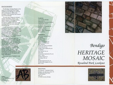
Merle Hall Collection: Rosalind Park Creative Village Bendigo Project Pamphlet for Rosalind Park Lookout - two copies. One side of the pamphlet has a layout image of the five sections of the mosaic and the poppet head base. The sections are numbers 1 to 5 Section 1: A stylised representation of the main Bendigo Goldfield based on a geological plan (Publish in 1992). It shows the lines of reef, including the famous Hustlers, Garden Gully and New Chum. Section 2: A typical cross section of the Bendigo Goldfields Section 3: The mine layout shown in this design features part of the Garden Gully line of reef. Section 4: Shown here is the Iron Bark mine on the Sheepshead reef. It has an interesting pattern of drives, stopes and winzes. Section 5: In this section the artist uses gold as her inspiration. The larger mosaic shows quartz veins winding through the earth containing gold in its various forms. The smaller mosaic represents the atomic structure of gold. It shows the the nucleus, the six shells of the atom, their electrons and orbits. The other side of the pamphlet describes the background of the community arts project, the artist, and volunteer workers, also notes mentioning the Bendigo community history. It also lists the donors for funding and business's that supported the project, with special thanks to Eric Wilkinson - Geolpogical advoser, the students and staff from Camp Hill, St Killians and Violet Street primary schools. BRIT and La Trobe University, bendigo. -
 Bendigo Historical Society Inc.
Document - KANGAROO FLAT GOLD MINE COLLECTION: MEMO TO SANDNER FROM WILLMAN
Two page memo 17 January 1984, to R. Sandner, D. Cahill, R. Cameron, P.Vail and D. Andrew from C.E. William. Topics covered: Deborah lease project; Brunswick Mine Costerfield, E.L's 1397 and 1398; town planning permit application; historical research and geological assessment, dewatering programme.bendigo, gold mining, deborah lease project -
 Kew Historical Society Inc
Archive (Sub-series) - Subject File, Kew Historical Society, Geology (Kew), 1958
... sources. kew historical society - archives geology - kew (vic ...Various partiesReference, Research, InformationSecondary Values (KHS Imposed Order)Subject file containing some secondary sources. These include a Parks Victoria brochure on the Geology of Yarra Bend Park and a printout of a web page about the Collingwood Children’s Farm that includes information about the geological formation of the region.kew historical society - archives, geology - kew (vic)kew historical society - archives, geology - kew (vic) -
 Kew Historical Society Inc
Photograph - Yarra River, Studley Park, 1924
Henry Beater Christian (1886-1962) , was a descendant of one of the earliest settler families in Kew. Employed at the Kew Asylum as a 'public servant', he was a skilled amateur photographer, photographing numerous scenes in Kew and on his travels around Victoria. The majority of his photographs date from 1916 to 1929. His finest photographs are housed in two photograph albums. Digital copy of a photograph from page 7 of the 47-page photograph album containing 261 gelatinous silver images, loaned by Diane Washfold with permission given to digitise and hold a copy in our collection. This photograph reveals the cliffs and the remnant bush in 1924."Studley Park / Kew"henry beater christian (1886-1962), landscape photography, kew (vic.) — yarra river, christian-washfold collection, photograph albums, yarra river -- geology, studley park -
 Kew Historical Society Inc
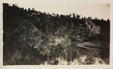
Plan, Loder & Bayly, Heidelberg: Historic River Landscape Assessment, 1982
Gwen McWilliam is well known as an authority on the history of Boroondara and the author of a large number of books and pamphlets about the City. She was awarded the medal of the Order of Australia in 2001 ‘for service to the community of Hawthorn and district, particularly through the research, documentation and publication of its history.’ This map from her collection was donated to the Kew Historical SocietyPlan of Heidelberg, annotated with details about the occupancy pre and post European settlement. The plan also contains geological references. The plan is included and analysed in volume 2 of the Heidelberg Conservation Study (1985). The original plan was published created in 1982. Printed annotationscity of heidelberg, yarra valley, historic plans -- heidelberg -
 Sunbury Family History and Heritage Society Inc.
Photograph, Bulla Primary School, Hanging Rock, 1995
In 1995, the upper school students from Bulla Primary School attended a camp at Hanging Rock Reserve which is part of the Macedon Ranges. At this camp the students were shown basic rock climbing skills and explored the rock for its interesting geological formations. Hanging Rock, also known as Mount Diogenes, is the traditional land of the Dja Dja Wurrung, Woi Wurrung and Taungurung people. It is a mamelon formed when magma poured from a vent and congealed. There are interesting rock functions at the site such as the Colonnade, the Eagle and the UFO. The highest point on the rock is 718metres above sea level and 105 meters above the land at its base.Hanging Rock is an important geological and volcanic structure in the Macedon Ranges area and in central Victoria. A non-digital coloured photograph of three holiday cabins and a barbecue in a bushland setting. A red car is parked outside one of the cabins as well as two permanent picnic tables.hanging rock, mount diogenes, mamelons, volcanoes, school camps, bulla primary school -
Stawell Historical Society Inc
Archive, Geological Survey of Victoria 1903 Brown Cover, 1903
1903 Brown Coverstawell, mining -
Stawell Historical Society Inc
Map, Victorian Geological Map, 1963
Victorian Geological Mapstawell, mining -
Stawell Historical Society Inc
Map, Geological Survey of Victoria
Geological Survey of Victoriastawell -
 Surrey Hills Historical Society Collection
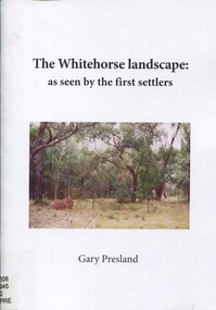
Book, The Whitehorse landscape as seen by the first settlers, 2011
This book describes the type of vegetation that covered the landscapes of the area, where streams flowed, when wetlands occurred and which species of mammals, birds, reptiles, fish & insects inhabited the area. Author: Gary Presland.This book describes the type of vegetation that covered the landscapes of the area, where streams flowed, when wetlands occured and which species of mammals, birds, reptitles, fish & isects inhabited the area. Author: Gary Presland.whitehorse region, natural history, vegetation, fauna, geology, (mr) gary presland -
 Surrey Hills Historical Society Collection
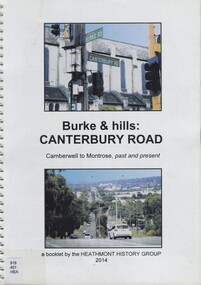
Book, Burke & hills: Canterbury Road, Camberwell to Montrose, past and present, 2014
Co-author Gerry Robinson was a speaker at a Surrey Hills Historical Society (SHHS) meeting. Lyndel Walker, member of SHHS, purchased the book for the collection. This book examines the changing landscape of Canterbury Road from the early days of settlement until today (2015)This book examines the changing landscape of Canterbury Road from the early days of settlement until today (2015)burke, surrey hills, canterbury, broughton park, vegetation, (mr) denis delaney, geology, (mr) john mcclare, geography, (mrs) mary mcclare, churches -
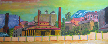 Federation University Art Collection
Painting - Artwork - Painting, 'School of Mines New Beginnings part a & b' by John Collier, 2008
John COLLIER (1937- 2012) John Collier was born at Ballarat in 1937. He received a Diploma of Mining and a Diploma of Civil Engineering at the Ballarat School of Mines (SMB), later graduating from the University of Melbourne with a Bachelor of Engineering (Mining). Early in his career he received a Diploma of Accountancy from the Australian Society of Accountants. Collier believes his experience at SMB had a profound influence on his life, especially what he learnt in Geology, Engineering, Chemistry, etc., all of which he found beneficial to his later working life and he is proud of that association. Through his experience in the world-wide mining industry John Collier has made a major impact on the mining industry. He has been exploration leader for a large number of worldwide discoveries and farm-ins both major and minor. He has experience in every facet of the mining industry, and his record in identifying diamond opportunities include Australian (Argyle), Canada (Diabik), Zimbabwe, and the Brazil Pipe (Collier Falls). His success in diamond exploration may be unparalleled. John Collier also has significant success with lead-zinc, iron ore, coal, copper, gold-silver, petroleum, heavy minerals, nickel, uranium, industrial minerals, rare earths, and tin. In 2006 John Collier was made a Legend in Mining by the Australian Mining Industry. Over his last 10 years, he had become a passionate painter, holding several successful solo exhibitions. His naive style featured beautiful and unexpected colour combinations. Many of his most lauded paintings depicted mining scenes, harking back to his Ballarat days. This item is part of the Federation University Art Collection. The Art Collection features over 2000 works and was listed as a 'Ballarat Treasure' in 2007.Two artworks by John Collier inspired by his alma mater, the Ballarat School of Mines. art, artwork, john collier, ballarat school of mines, alumni -
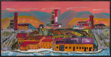 Federation University Art Collection
Painting - acrylic on canvas, Collier, John, 'Port Phillip Colonial GMC, Clunes' by John Collier, 2008
John COLLIER (1937- 2012) John Collier was born at Ballarat in 1937. He received a Diploma of Mining and a Diploma of Civil Engineering at the Ballarat School of Mines (SMB), later graduating from the University of Melbourne with a Bachelor of Engineering (Mining). Early in his career he received a Diploma of Accountancy from the Australian Society of Accountants. Collier believes his experience at SMB had a profound influence on his life, especially what he learnt in Geology, Engineering, Chemistry, etc., all of which he found beneficial to his later working life and he is proud of that association. Through his experience in the world-wide mining industry John Collier has made a major impact on the mining industry. He has been exploration leader for a large number of worldwide discoveries and farm-ins both major and minor. He has experience in every facet of the mining industry, and his record in identifying diamond opportunities include Australian (Argyle), Canada (Diabik), Zimbabwe, and the Brazil Pipe (Collier Falls). His success in diamond exploration may be unparalleled. John Collier also has significant success with lead-zinc, iron ore, coal, copper, gold-silver, petroleum, heavy minerals, nickel, uranium, industrial minerals, rare earths, and tin. In 2006 John Collier was made a Legend in Mining by the Australian Mining Industry. Over his last 10 years, he had become a passionate painter, holding several successful solo exhibitions. His naive style featured beautiful and unexpected colour combinations. Many of his most lauded paintings depicted mining scenes, harking back to his Ballarat days. This work and subject matter was painted for the artist's alma mater, the Ballarat School of Mines (now Federation University Australia). This item is part of the Federation University Art Collection. The Art Collection features over 2000 works and was listed as a 'Ballarat Treasure' in 2007.Colourful acrylic on canvas painting depicting the Port Phillip Gold Mining Company, Clunes.art, artwork, john collier, port phillip cold mine, clunes, clunes, available, alumni, mining -
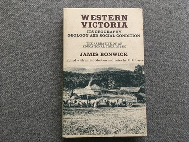 Port Fairy Historical Society Museum and Archives
Book, James Bonwick, Western Victoria It’s geography geology and social condition. The Narrative of an Educational Tour in 1857
1857 tour of Western Victoria including Tower Hill, Belfast and Yambuk.non-fiction1857 tour of Western Victoria including Tower Hill, Belfast and Yambuk.colonial education, belfast, victoria 1857, book -
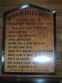 Parks Victoria - Mount Buffalo Chalet
Plaque, "Buffalo Falls Hotel / Historic list of prominent guests 1888-1919"
Possibly predates Chalet. ".There is also a wooden plaque displaying the names of notable guests who stayed at the Buffalo Falls Hotel that once stood at the foot of the mountain. the pioneering Manfield family opened this early hotel in the late 1880's and soon began taking visitors on walking treks up onto the plateau." (Pg 84 Historica, 2011). The Buffalo Falls Hotel was originally known as The Buffalo Falls Temperance Hotel and was built in 1888 by James Manfield. His daughter Alice became well known as a Mt Buffalo guide and was renowned for her mountain knowledge as well as for her distinctive alpine pant suit. The Hotel was constructed opposite the newly opened 'Staker's Track', a walking track , now known as the "Big Walk" was, a steep 6 hour walk, which nevertheless opened the mountain up to early tourism, attracting leading figures from Melbourne Society as well as significant artists, Naturalists and Scientists eager to explore and experience the unique scenery and geological features of the Mountain. Baron Von Mueller as Government botanist was one of the first white men to ascend to the plateau in 1853, collecting alpine specimens . Each of the names on this honor roll were significant cultural and society figures of Victorian/Edwardian Melbourne .Listed in Draft Inventory of Significant Items. Appendix A3. Framed Photographs, Pictures, etc. (Pg 165, Historica, 2011)Wooden plaque with black painted inscription, framed in black painted wood. Plaque is peaked at the top."BUFFALO FALLS HOTEL.... Historic list of prominent guests 1888-1919. Proprietor Jane R. Manfield. Lord Hopetoun. Lord & Lady Brassey. Lord Lamington. Baron Sir F. Von Mueller. Sir William Zeal. Judge Sir H. William & Lady William. David Syme & Mrs Syme. Percy Grainger. Sir John & Lady Monash. George Farlow A.D.C. Prepared by Geo. W. Sykes "Buffalo House'." -
 Wodonga & District Historical Society Inc
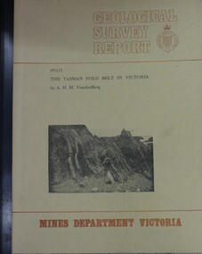
Booklet - The Tasman fold belt system in Victoria : geology and mineralisation of proterozoic to carboniferous rocks, A.H.M. Vanden Berg, 1976
A scientific analysis of the development of the sequence of geological events and processes which contributed to the building of southeastern Australia landforms as part of the Tasman Fold Belt System.non-fictionA scientific analysis of the development of the sequence of geological events and processes which contributed to the building of southeastern Australia landforms as part of the Tasman Fold Belt System.geology victoria, landforms victoria, tasman fold belt -
 Eltham District Historical Society Inc
Book, Jenny Brown et al, Out of the Mist; Osborne Peninsula, 2024
The Osborne Peninsula on the Yarra River at Warrandyte accommodates a limited number of properties and residents (70 households). The area is rich in geology and ecology, and an unusually rich endowment of human, built and creative history. Contents: Welcome: The landform: The River: Aboriginal occupation: The Miners: North Warrandyte :The Subdivision: The Lowes: The Osbornes: The Last Osborne: The Elders: The Relics: Dray Track: Water Wheel"Kauri Plaque: River track: Pines: Windmill Creek Bridge: The Koornong School: The Houses" Man Cave: MidCentury Classic: Enduring Original" Masterwork: The Muddies: The State Park: The Saving of Koornong Reserve: The Landcare Story: Flora and Fauna: The Vulnerable, Endangered and threatened: Birds: Mammals: "Waring" the wombat: Reptiles: Fish: Invertebrates: Flora: Fire. Published by the North Warrandyte (Osborne Peninsula) Landcare Group. Includes photos from EDHS collection.64 p. : ill., map ; 29.7 x 21 cm. (2 copies)yarra river, birrarung, dray track, fauna, geology, houses, indigenous history, koornong reserve, koornong school, lowe family, mining, mudbrick houses, north warrandyte, osborne family, warrandyte state park, water wheel, north warrandyte (osborne peninsula) landcare group, osborne peninsula -
 Bendigo Historical Society Inc.
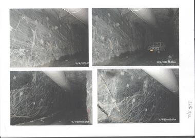
Photograph - Kangaroo Flat Gold Mine Collection: underground in Swan Decline, Kangaroo Flat Gold Mine, 2000
The modern mine is accessed via the Swan Decline, which commences at the Kangaroo Flat site on the southern outskirts of Bendigo and progresses in a north easterly direction between the Deborah and Sheepshead anticlines, reaching a depth of almost 1000 m below the City of Bendigo. Development of this decline commenced in 1998. Swan Decline closed and history preserved In a major rehabilitation milestone at Kangaroo Flat, the Swan Decline Bendigo’s primary gateway to underground mining, was permanently closed in December 2022. Important parts of Bendigo’s gold rush history were also preserved from the onsite office buildings with 19 boxes of records, and 1350 old photos being scanned and provided to the local historical societies and the Goldfields Library Corporation. A volunteer from the Bendigo Historical Society, Kay MacGregor, also scanned approximately 40 bookshelves of newspaper clippings to assist with recording and preserving geological drilling locations.Black and white photocopies of photographs of Swan Decline, showing some stages of underground construction. Eleven images on 3 pages, dated 16/4/2000 (10 a.m.) show decline walls, rock bolts and markout of tunnel shape. One image shows a utility in the tunnel. Final three images on one page, have notations on the photos: 'opposite SP18 LHS decline', 'just up from previous 3 box positions' and 'just up from tank, same side' On bottom RH side 'spots for scale attention, IT required, all lower decline.' All three images dated 12/6/2000.goldmining, kangaroo flat gold mine, western mining corporation, unity mining, swan decline -
 Warrnambool and District Historical Society Inc.
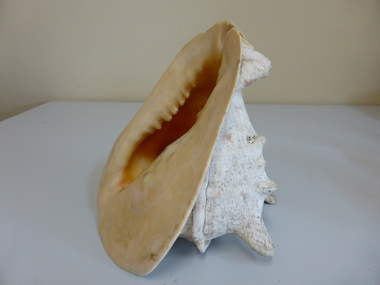
Geological specimen - Household, Shell Conch
A conch shell is a tropical marine mollusc with a robust spiral shell which bears long projections and has a flared lip No information is available about where this shell came from or when it was acquired by the Warrnambool and District Historical Society.This item has no known local provenance but would be useful for display as an attractive marine item which is no longer able to be taken from its original locationLarge white conch shell with pink and yellow coloured lip. Stands upright. Four points. One point broken off at tip and lip edge sightly broken.warrnambool, shell -
 Whitehorse Historical Society Inc.
Document - Speech, Gerry Robinson, Heathmont History Group, The Histories of Heathmont by Gerry Robinson, August 2023
A talk on the "Histories of Heathmont" given by Gerry Robinson of the Heathmont History Group at the 2023 AGM of the Whitehorse Historical Society, Mitcham.A talk on the "Histories of Heathmont" given by Gerry Robinson of the Heathmont History Group at the 2023 AGM of the Whitehorse Historical Society, Mitcham.non-fictionA talk on the "Histories of Heathmont" given by Gerry Robinson of the Heathmont History Group at the 2023 AGM of the Whitehorse Historical Society, Mitcham.heathmont, gerry robinson, urbanisation -
 Bendigo Historical Society Inc.
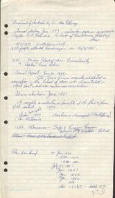
Document - MINING REPORTS - MINING REPORTS BY A RICHARDSON
Handwritten reports dated May 1968 by A. Richardson. On the 4th May visitors from Hobart toured the Central Nell, Victoria and New Chum Hill areas. Also on the 4th, a visit from Mr Geo Lambert who gave him a geological report of the Victoria Hill area. On the 13th May, a visit from Mr K W Smith who showed him slides of derelict W. A. mines. Also plans for the preservation of Mining in Bendigo at Victoria Hill and the preservation of the Central Nell Gwynne poppet legs.document, mining reports, mining reports by a richardson, mr geo lambert, hon j c balfour, mr n wakefield, mr k w smith, le fevre boy's tech high school, mrs f leak, mr perry, gt extended hustlers, central nell gwynne, the pioneer, gunther & party, lansell's fortuna, mt alvernia hospital, a richardson, devonshire mines, bendigo & district tourist association, mrs checcucci, mr jackman, mr greenway, r a c v, cl gerry, eureka extended, bendigo branch historical society -
 Bendigo Historical Society Inc.
Document - Great Extended Hustlers Gold Mine, Albert Richardson
Seven men were killed at the Great Extended Hustler's mine disaster on 2nd May 1914 by an explosion of dynamite occurring as the men were waiting at the plat to ascend the mine at the end of their shift. No blame was attached to anyone in the findings of the inquisition. It was unknown what caused the dynamite to explode. This document formed part of the research done at the time by Bendigo Historical Society, of the 100 years commemoration of the mine disaster, held at Hustlers Hill in 2014. Six page copy of research document, describing the history and geology of the Great Extended Hustlers Mine and the Great Extended Hustlers Reef Q.M. Co.. Topics include: general overview of history, mines along the Hustlers line, characters of the saddle reefs, gold occurrences, effect of pitch, influence of faulting, payable reefs and saddle reefs and spurs. Mine overview researched by Mr. Albert Richardson. great extended hustlers, goldmining, hustlers consols, united hustlers and redan, k.k. mine, comet, hustlers reef no. 1, hustlers reef, hustlers royal reserve co., park shaft, hustlers royal reserve no. 2, city shaft, fortuna hustlers -
 Bendigo Historical Society Inc.
Document - Geological Survey of Victoria, Hustlers Line of Reef, Bendigo, April, 2014
Seven men were killed at the Great Extended Hustler's mine disaster on 2nd May 1914 by an explosion of dynamite occurring as the men were waiting at the plat to ascend the mine at the end of their shift. No blame was attached to anyone in the findings of the inquisition. It was unknown what caused the dynamite to explode. This document formed part of the research done at the time by Bendigo Historical Society, of the 100 years commemoration of the mine disaster, held at Hustler's Hill in 2014. Seven page photocopy of Department of Mines, Bulletin, Geological Survey of Victoria, Hustlers Line of Reef, Bendigo, No. 33 by H.S. Whitelaw. Includes plan of Hustlers Royal Reserve No. 2, (main shaft) showing location on Pall Mall, and location of Post Office and Law Courts; plan of location of Hustlers Royal Reserve No. 2 (Park Shaft) showing Jail (sic), Camp Hill State School, two 'lagoons' in between tennis court, croquet court and bowling green; a plan of the Great Extended Hustler's Shaft and two copied images of Hustler's Hill showing mining buildings, poppet heads and chimneys. Comet, K.K., Hustler's No. 1, Old Comet and United Hustler's and Redan Mines are shown in the images. great extended hustlers, goldmining, accident, quartz, mining, k.k. mine, comet mine, hustler's line of reef, old comet, united hustler's, redan