Showing 1102 items
matching information map
-
 Marysville & District Historical Society
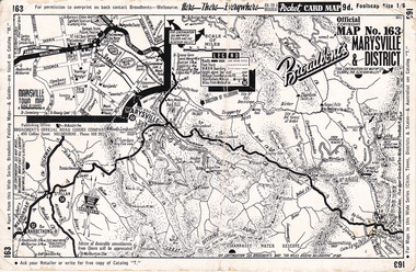
Ephemera (Item) - Pocket card map, Broadbent's Official Road Guides Company, Broadbent's Map No. 163 Marysville & District, 1950s
A pocket card map of Marysville and the district. Drawn map of Marysville and the district. Has a legend, scale and a town map of Marysville. Gives an address for Broadbent's Publishing Office of 475 Collins St Melbourne and a Melbourne telephone number - MR 2021. Reverse has advertisements for Barton's Store and Marylands Guest House in Marysville.A pocket card map of Marysville and the district. Gives information about Marysville and the district. Broadbent's was a prolific publisher of maps. marysville, victoria, maps, broadbent's, barton's store, marylands guest house -
 Marysville & District Historical Society
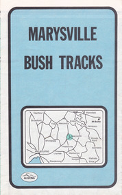
Map (Item) - Bush tracks map, John Siseman et al, MARYSVILLE BUSH TRACKS, 1987
A fold out map of the bush tracks in and around Marysville with information regarding each track. This map was published by Pindari Publications and distributed by Algona Publications. The track notes were compiled by John Siseman in 1987. The map was drawn by Glenn van der Knijff.A fold out map of the bush tracks in and around Marysville with information regarding each track.marysville, victoria, australia, map, bush tracks, pindari publications, algona publications, john siseman, gleen van der knijff, lady talbot forest drive, beauty spot walk, michaeldene track, steavenson falls, tree fern gully walk, trestle track, phantom falls, marysville town walk, marysville lookouts round walk, keppel falls, the beeches round walk, cumberland scenic reserve, cambarville, lake mountain, lake mountain walking track -
 Marysville & District Historical Society
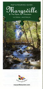
Map (Item) - Map and touring guide, Murrindindi Regional Tourism Association Inc, Marysville & The Mystic Mountains VICTORIA-AUSTRALIA, 08-2002
A fold out map and touring guide of Marysville and the surrounding district published in 2002 by Murrindindi Regional Tourism Association Inc.A fold out map and touring guide of Marysville and the surrounding district published in 2002 by Murrindindi Regional Tourism Association Inc.marysville, victoria, australia, map and touring guide, mystic mountains tourism, the beeches rainforest walk, lake mountain, cambarville, cathedral range state park, the cumberland, abbey green b&b cottages, anastasia fairytale cottage, ashlar cottage b&b, somerled mountain retreat, baree mudbrick cottages, blackwood cottages, camellia cottage, cathedral view b&b, cottage riverside, crossways country inn, dalrymples guest cottages, esa country ministries, hillcrest, keppels hotel motel, kerami house, lomatia lodge, lyell guest cottages, marylands country house, marysville caravan park, marysville holiday cottages, maryton park, melina cottage, moondai farm b&b, mountain lodge marysville, mount cathedral lodge, mystic mountains holiday cottages, nanda binya lodge, rendezvous on murchison, scenic b&b, the hermitage, tower motel, waratah house, willowbank at taggerty, woodlands of narbethong, keppels, lake mountain resort cafe, lanterns at willowbank, mantirri blueberry farm, marysville country bakery, the old woolshed cafe, clearstream olives, uncle fred & aunty val's old style lolly shop, acheron valley alpacas country store & gallery, bruno's art and sculpture garden, country touch, things of sand & stone, willowbank gallery, marysville auto & hardware, marysville newsagency & general store, marysville visitor information centre, narbethong visitor information centre, gallipoli park, keppels lookout, lady talbot drive, steavenson falls, steavenson river, taggerty river, acheron river, black spur trail riding centre, buxton trout farm, lake mountain resort ski hire, lake mountain ski school, marysville district country club, marysville ski centre, narbethong ski hire, rubicon horse riding, country touch tours, murrindindi regional tourism association inc -
 Marysville & District Historical Society
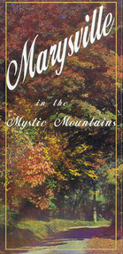
Map (Item) - Information brochure, Project Art & Photo, Marysville in the Mystic Mountains, Unknown
... Mountains Map Information brochure Project Art & Photo Mystic ...An information brochure on Marysville, the surrounding district and the natural attractions in the region published by Mystic Mountains Tourism.An information brochure on Marysville, the surrounding district and the natural attractions in the region published by Mystic Mountains Tourism.marysville, victoria, australia, information brochure, mystic mountains, mystic mountains tourism, cathedral range, lady talbot drive, cameron cascades, phantom falls, keppel falls, beech forest cascades, the beeches rainforest walk, the big tree, cumberland memorial scenic reserve, cambarville, cumberland falls, cora lynn falls, the big culvert, steavenson falls, lake mountain, marysville visitor information centre -
 Marysville & District Historical Society
Map (Item) - Tourist map, Mystic Mountains Tourism, OFFICIAL VISITORS' MAP MARYSVILLE LAKE MOUNTAIN, Unknown
A visitors' map of Marysville and Lake Mountain produced by Mystic Mountains Tourism for Visit Victoria.A visitors' map of Marysville and Lake Mountain produced by Mystic Mountains Tourism for Visit Victoria.The Marysville and Lake Mountain Visitor Map and Touring Guide has been compiled and/ published by Mystic Mountains Tourism Inc. Copyright./ Production and artwork Graph Attack P/Lmarysville, lake mountain, victoria, australia, visitor's map, official visitors' map marysville lake mountain, buxton, narbethong, taggerty, visit victoria, mystic mountains tourism inc, graph attack p/l, mystic mountains, marysville triangle, marysville visitor information centre, marylands country house, black spur, steavenson falls, lady talbot drive, cambarville, cathedral ranges, wirreanda festival, lake mountain summit walk, summit walk loop, leadbeaters loop, day loop walk, buxton hotel, igloo roadhouse, karmann waters, silverstream b&b cottages, buxton trout and salmon farm, the niche wine bar, buxton post office & general store, choppers buxton roadhouse, woodlands rainforest bungalows, chestnut glade, black spur inn, wombat cottage, abbey lake luxury b&b spa cottages, mystic mountain ski hire & outdoors, pnl 4wdriving, blue views holiday units & ski hire, marapana agistment park & farm stay b&b, danico design, things of sand & stone, mantirri blueberry farm, allawah country cottages, amberview cottages, ashlar cottage b&b, black spur motel & caravan park, blackwood deluxe cottages, blackwood courtyard b&b, dalrymples guest cottages, delderfield, el kanah guest house, fruit salad farm, kerami guest house, keppels hotel, lake mountain-snow gum lodge, lomatia lodge, lyell guest cottages, magnolia house, keppel waters, lyrebird apartments, marysville caravan park, all view spa apartments, riverside cottages, maryton park b&b country cottages, melina cottage, mountain lodge, mystic mountains holiday cottages, nanda binya lodge, rendezvous luxury cottages, scenic b&b motel, the cumberland, south cathedral farm, tower motel, willowbank at taggerty, woodlands rainforest retreat, marysville & district country club inc, mystic mountains ski hire & outdoors, rubicon valley horse riding, marysville trout and salmon ponds, gallipoli park, keppels lookout, cambarville-yarra ranges national park, lake mountain-yarra ranges national park, lady talbot drive-yarra ranges national park, cathedral range state park, steavenson river, taggerty river, acheron river, lake mountain alpine resort, bruno's art and sculpture garden, manical mechanicals, uncle fred & aunty val's old style lolly shop, carmyle farm boutique, crossways historic country inn, fraga's, gilberts restaurant, heights licensed bistro, the old woolshed cafe, cathedral view natural therapies, crystal journey -
 Marysville & District Historical Society
Flyer (item) - Information Flyer, Forests Commission, Victoria, Cumberland Scenic Reserve, 1918-1983
An information flyer that was produced as a guide to the Cumberland Scenic Reserve by the Forests Commission of Victoria. The Forests Commission Victoria (FCV) was the main government authority responsible for management and protection of State forests in Victoria, Australia between 1918 and 1983. The Commission was responsible for ″forest policy, prevention and suppression of bushfires, issuing leases and licences, planting and thinning of forests, the development of plantations, reforestation, nurseries, forestry education, the development of commercial timber harvesting and marketing of produce, building and maintaining forest roads, provision of recreation facilities, protection of water, soils and wildlife, forest research and making recommendations on the acquisition or alienation of land for forest purposes″. The Cumberland Scenic Reserve is set in the heart of the mountain forests of Victoria and is 16km east of Marysville on the Cumberland Road. This reserve forms part of the catchment of Armstrong Creek, a tributary of the Yarra River which provides water for the Melbourne area. The reserve is a prime mountain ash area in which is set the old Cambarville sawmill and village site.An information flyer that was produced as a guide to the Cumberland Scenic Reserve by the Forests Commission of Victoria. 423Aforests commission victoria, cumberland scenic reserve, marysville, victoria, cambarville, the big tree, cora-lyn falls, barton's lookout, cumberland falls, sovereign view, armstrong creek, yarra river, mountain ash -
 Glen Eira Historical Society
Document - HOWITT FAMILY
Four documents on the history of the Howitt family: 1/A photocopied extract on Dr. Godfrey Howitt, taken from biographical information in ‘A Woman of Importance’, by Jean Uhl. Information details his family history, religion, his medical affiliations, his garden in Collins St. 2/Two page print out from Wikipedia done 13/12/2013 on Godfrey Howitt giving family history and his medical history in Melbourne; includes a sketch of him. 3/Family tree map by Claire Barton. 4/Print out on Alfred William Howitt, taken from Monash website, on his life as an explorer, geologist and anthropologist. Monash University’s Howitt Hall is named in his honour.howitt godfrey dr., howitt mrs., bakewell miss, howitt william, bakewell phoebe, caulfield, howitt alfred william, melbourne hospital, benevolent asylum, howitt william godfrey, farms, entomologist, howitt john henry, howitt charles, medical school committee, university of melbourne, philosophical society of victoria, royal society of victoria, magistrate, howitt hall, explorer, geologist, anthropologist, ‘howittia’ blue-flowered mallow -
Glen Eira Historical Society
Article - Rosstown Railway
This file contains three items: 1/A review of the ROSSTOWN RAIL TRAIL from LIVING IN GLEN EIRA, vol. 11, 2004, Issue 4, no. 25, date and author unknown. The review explains the purpose of the Rail Trail with a brief narrative of the history behind Rosstown Sugar Mill Railway line. Concluding with information on the location of the Trail and the expected time required to walk the entire track included in the review is a map of the Rail Trail, which marks significant sites along the trail with historic pictures. 2/A newspaper article from THE AGE, dated Tuesday 21/10/1980 and written by Iola Matthews, reporting on the circumstances that led to the publication of the book RETURN TO ROSSTOWN written by Des Jowett and Ian Weickhardt. The article begins with a brief biography of the authors before moving into details of the book’s content, providing a further biography of W. Murray Ross which includes information on his financial ventures – particularly the Rosstown Rail – his marriage and children. The article includes a black and white photograph of Weickhardt and Jowett walking along the route of the railway line, an illustration of the Rosstown sugar works and a map of the area surrounding the site of the mill. 3/Three photocopies of a black and white illustration of the Rosstown sugar works from the east, undated and artist unknown.rosstown rail trail, rosstown, ross william, ross w. murray, ross murray, sugar beet mills, mills, elsternwick, land transport, railways, railway lines, railway routes, carnegie neville street, carnegie miller street, factories, market gardens, horticulture, peat, soils, land forms, topography, geology, civic issues, cone sugar industry, elsternwick plaza, elsternwick, glenhuntly road, parks and reserves, ee gunn reserve, caulfield racecourse, sportsgrounds, caulfield, carnegie, riddell parade, clarence street, aileen avenue, princes park, dover street, marara road, oakleigh road, rosanna street, murrumbeena crescent, north road, kooyong road, hawthorn road, booran road, koornang road, poath road, warragul road, railway platforms, railway buildings, bambra road, swamps, landforms, landfill, council landfill, railway bridges, bridges, railway underpasses, sporting clubs, tennis clubs, bowls clubs, rosstown railway, rosanna street reserve, maps, railway maps, living in glen eira, weickhardt ian, jowett des, caulfield south, curraweena road, oakleigh, caulfield technical school, return to rosstown, beet sugar industry, crops, land booms, land development and subdivisions, bent thomas, fink benjamin, sugar works, rosstown hotel, oamdenong road, rosstown dry cleaners, shops, rosstown road, rosstown plate, people by circumstance, migrants, accountants, occupations, professionals, the grange, real estate, grange road, financial agents, judges, rosstown estate, financial trouble, rabbit preserving, breweries, political debates, political issues, political electorates, politics, political science, debt, financial loans, court procedures, court cases, legal events and activities, malleson and riggall, widowers, seabeach railway, economics, economic deadline, depression 1890s, economic crash, mortgages, divorce, social problems, poverty, ross claude, ross roderick, world war 1914-1918, wars, military history, servicemen, australian flying corps, engineers, caulfield council, swagmen, homelessness, glenhuntly road, glenhuntly road tram, woornack road, leila road, wild cherry road, melten avenue, illustrations, steam trains, trains, horse and cart, horse-drawn transport, railway stations -
Glen Eira Historical Society
Letter - Rosstown Railway
This file contains four items: 1/A black and white photocopy of a letter dated either 07/08/1889 or 09/08/1889, from Robert Lundon to an unidentified recipient discussing an agreement reached between the author – on behalf of the recipient – and Soon Hang Hi in regard, in regards to the allotment known as Webber’s. The agreement is outlined in the letter in what appears to be Chinese characters, and includes the marks of Robert Lundon and Soon Hang Hi. File note from Joy Wu states that the calligraphy is not Mandarin or traditional Chinese. 2/Three sheets of hand-written working notes with information taken from the Victorian Government Gazette on THE ROSSTOWN AND MURRUMBEENA LAND COMPANY LIMITED, THE ROSSTOWN JUNCTION RAILWAY AND PROSPERITY COMPANY LIOMITED, and THE ROSSTOWN JUNCTION, ELSTERNWICK, AND OAKLEIGH RAILWAY COMPANY LIMITED, covering dates between 1887 and 1894. The notes concern meetings and creditors claims relevant to the companies, with reference numbers for the information source. Date and author of the notes are not recorded. 3/A black and white photocopy of the a partial map of the Rosstown Railway and surrounding area, undated. The map includes the names of landholders in the areas of Brighton, Garden Vale and Elsternwick, as well as other railway lines present in the region. 4/A fold-out map and guide of the Rosstown Rail Trail, including a brief general history of Caulfield as well as a more extensive biography of William Murray Ross and the Rosstown Railway. The map marks and describes significant sites along the trail, including photographs of some of these sites, provided by DF Jowett.documents, correspondence, webber’s, lundon robert, chinese characters, ethnic communities, signatures, text, settlements, taxes, fraser john grieves, lovell r.h., price davies, meetings, communication activities, soon hang hi, commercial events and activities, the rosstown and murrumbeena land company limited, victorian government gazette, bulmer richard, parry john, osment henry, shareholders, creditors claims, the rosstown junction railway and property company limited, finch and best, lawyers, the rosstown junction elsternwick and oakleigh railway company limited, cameron w.c., phillips p.d., garden vale, elsternwick, elsternwick railway station, rosstown, rosstown railway, thomas street, bay street, kooyong road, melbourne and brighton railway, hawthorn road, bambra road, caulfield and frankston railway, booran road, grange road, koornang road, murrumbeena road, north road, north road railway station, east brighton railway station, south road, railway routes, railway lines, railways, land transport, murphy j., caulfield, hamilton t.f., dane p., holloway, webb, ailee john, payne t.b., brodie chas, dane john, o’neil h., mccombie john, mcmillane a., smyth c.d., cooper, ebden, landholders, jeffrey j.d., gill j., balcombe a.e., cooper h., mcnab j., white j., sutherland j., greeves a.f.a., newton m.c., chamley f.b., fowler j., inglis p., grant t., stooke j., swanson g., cochrane c., adams e.b., mccombie thas, keyes robert, brighton cemetery, burials grounds and graveyards, war-ein road, were j.b., holland j., mcmahon c., winter t.l.m., dendy henry, mitchell w., jackson s., were j.e., wickham francis dawe, bryant jane, east brighton railway station, railway stations, maps, allotments, land titles, roads and streets, rosstown rail trail, city of glen eira, tourism, trains, tourism information bureaus, tours, pamphlets, elsternwick railway park, oakleigh junction, princes park, ee gunn reserve, packer park, sites, jowett d.f., weickhardt i.g., return to rosstown: railways land sales and sugar beet ventures in caulfield, land sales, walking trails, ross william murray, transport objects, locomotion, walking, cycling, driving, sports, country mansions, people, caulfield john, builders, construction and demolition workers, occupations, careers, professionals, topography, geology, landforms, horticulture, market gardens, primary industry workers, city of caulfield, mood kee, pennington harold, annual general meetings, caulfield town hall, glen eira city council, carnegie, carnegie station, rosstown station, people by circumstance, migrants, sugar beet, sugar beet mill, sugar beet industry, mills, factories, sea beach lines, bent thomas, parliamentary representatives, neville street, miller street, lemann’s swamp reserve, koornang park, cane sugar industry, breweries, rabbit processing plants, health establishments, hospitals, food production establishments, abattoirs, thieves, social problems, vagrants, theft, squatting, financial economics, debt, finance industry, insurance companies, company managers, bentleigh, ross leila, the grange, leila road, wild cherry road, financial trouble, mortgages, gisborne street, archibald street, riddell parade, victoria railways, glen huntly road, clarence street, college street, gladstone parade, parrell street, aileen avenue, seaview street, drion estate, land subdivisions, dover street, sussex street, landfill, marara road, booran road, woodville avenue, dorothy avenue, ormond park, royal avenue, ormond railway station, oakleigh road, melten avenue, miller street, munro avenue, lord reserve, neerim road, toolambool road, the rosstown hotel, rosanna street, murrumbeena crescent, commercial establishments, the national bank, rosstown road, kangaroo road, poath road, freda street, hughesdale kindergarten, oakleigh council, hughesdale community centre, civic establishments, galbally reserve, plaques, warrigal road, out and about brochures -
 Glen Eira Historical Society
Document - Melbourne and Metropolitan Board of Works
... contains information about water supply, sewerage and drainage.../2 maps and 1 information booklet from the Thomson Project ...This file contains five items relating to Caulfield Council Visits with the Melbourne & Metropolitan Board of Works (MMBW) from 1919 to circa 1974: 1/A photo album containing photos from the MMBW ‘visit to the Headworks, Yan Yean Water Supply, Wallaby and Silvery Creeks’ from 28/02/1919 to 03/03/1919, attended by members of the Caulfield City Council. The album contains 13 original black-and-white photographs, 3 of which are of the council members. The album is accompanied by a report by Felicitie Campbell, written 11/2008, about these visits. 2/A publication from the MMBW documenting its review of operations for 1973-1974. The report contains information about water supply, sewerage and drainage infrastructure completed or in progress during this period including infrastructure in Caulfield, Ormond, Carnegie and Bentleigh. 3/A periodical feature from the MMBW titled ‘Living City’, issue no. 16, Spring/Summer 1974. Included in the article titled ‘Program’ is a notice that construction will continue on the Elster Creek drain from Thomas St. to Wheatley Road, McKinnon. The periodical also includes the names of commissioners W. R. Walters from Caulfield and G. R. Bricker from Moorabbin (back cover). 4/2 maps and 1 information booklet from the Thomson Project Open Day attended by Felicite and John Campbell as representatives of the Caulfield City Council. This was an annual MMBW open date. Date unknown. 5/Resarch notes by Kate Aldred about the photo album and Thomson Project Open Day booklet and their links to Felicite Campbell 01/04./2014.koornang road, draper street, hall street, centre road, brewers road, caulfield intercepting sewer, byron street, caulfield park, elster creek, caulfield, carnegie, ormond, bentleigh, thomas street, brighton east, wheatley road, mckinnon, city of caulfield, bricker g. r., walters w. r., caulfield city council, melbourne and metropolitan board of works, hall councillor, murray councillor, murphy councillor, wharington councillor, phillips councillor, blyth councillor, best robert sir, reid doctor, jowett mr., wooley mr., hindle mr., annual reports, water supply structures and establishments, sewerage and sanitation, sewerage establishments, drainage, town planning, business and finance, councillors, mayors, acqueducts, dams and reservoirs, creeks, waterfalls, rivers, construction sites, north road, north road pumping station, cities and towns, campbell felicitie -
Glen Eira Historical Society
Document - MOORABBIN TRANSIT
This file contains one item: 1/A Moorabbin Transit printout of the bus timetable information for Route 822, effective 05/08/2002. Includes a description and a map of the route.princes highway, murrumbeena road, sydney street, hobart road, neerim road, crosbie road, north road, malborough street, stockdale avenue, gardeners road, quinns road, east boundary road, murrumbeena, bentleigh east, buses -
 Glen Eira Historical Society
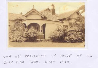
Letter - Maher, Francis Patrick
Correspondence between Mr Frank Maher and Felicitie Ampbell re information about a property at 173 Glen Eira Road, St Kilda East. Included is a copy of Frank Maher’s recollections of people and places around east St Kilda area. Also includes a copy of a photograph of his childhood home c. 1930 and a map of the area around the property where he lived.st kilda east, elsternwick, caulfield, myrtle street, bailey ave, atley grove, glen eira road, hotham street, glenhuntly road, elizabeth street, regent street, balaclava road, mcwhae ave, gordon street, ripponlea mansion, caulfield grammar school, caulfield race course, elsternwick police station, caulfield city hall, city of glen eira city hall, glen eira historical society, holy angels catholic church, st. josephs catholic church, a.r.p. wardens, drill hall, brighton rifles, grocers, sweet shops, terrace houses, tennis courts, saddlers, billiard rooms, horse drawn vehicles, market gardens, motor cycles, fuel merchants, maher frank, tracey martin brian, tracey john edmond, tracey margaret, maher mary eleanor, maher martin john, tracey kathleen, bent thomas, nathan benjamin -
Glen Eira Historical Society
Book - GLEN EIRA GUIDE
This file contains one item: 1/A copy of the 1999 edition of the Glen Eira guide. This magazine aims to provide readers with useful information for living and working within the City of Glen Eira. It is divided into five principal sections. The first section, titled Glen Eira City Council Information, provides information pertaining to the local government. It includes information about Council meetings, the names and contact details of the six members of the Council, information about services offered by the Glen Eira Service Centre, the contact details for particular services offered by the Glen Eira City Council, information about rates and valuations, information about the building permit application process, information about waste management, and federal and state electoral maps. The second section, titled Council and Community Resource Guide, consists of a list of the various local community facilities and organizations. The third section, titled City of Glen Eira Safe Food Guide, consists of a list of food venues nominated by the Glen Eira City Council Environmental Health Services Department for their commendable level of hygiene. The fourth section, titled City of Glen Eira Business Development Unit, provides information about the eponymous local government department, which is aimed at providing aid to local businesses. The fifth and final section, titled ‘Think Local, BUY LOCAL’ Guide, consists of a list of local businesses, grouped according to industry, to try and encourage the support thereof.glen eira, city of glen eira, glen eira city council, local government, local officials and employees, kennedy norman cr, mayors, public utilities, community services, local government departments, rates, local government, building permits, waste disposal, community groups, cultural structures and establishments, law and order, libraries, education, educational and research establishments, religious groups, clubs and associations, community centres, food, restaurants, businesses -
Glen Eira Historical Society
Document - Moorabbin Transit
This file contains one item: 1/A Moorabbin Transit printout of the bus timetable information for Route 822, effective 05/08/2002. Includes a description and a map of the route.princes highway, murrumbeena road, sydney street, hobart road, neerim road, crosbie road, north road, malborough street, stockdale avenue, gardeners road, quinns road, east boundary road, murrumbeena, bentleigh east, buses, bus stops, bus services, transport -
 Flagstaff Hill Maritime Museum and Village
Functional object - Ship's Wheel
This wooden ship's wheel originally had eight spokes but four are no longer in their sockets. One of the spokes has been shaped. Both sides of the wheel have a brass cap over the centre of the hub, covering the wooden hub. The wood is split and cracked, and parts of it have small holes, a sign of being affected by the sea worm. Thick encrustations are on parts of the wheel, showing that it has been on the sea bed for quite some time. The donor is a Warrnambool resident. Years ago he was cray fishing at King Island, which is in Bass Strait, northwest of Tasmania. His craypot got stuck in a reef so a diver helped him by retrieving the craypot for him. While the diver was underwater he also stumbled across the ship's wheel, which he gave to the donor. The Bass Strait is a very narrow route that was difficult and dangerous to navigate in the early 19th century, before good maps, communications and lighthouses were installed. The area, including King Island, is the graveyard of many ships that almost made it to their destination of Melbourne along Australia's treacherous coastline. Around King Island alone, many ships and lives were lost. There is no information about the history of this ship's wheel. Its condition shows that the item has been under the water for a long time. However, there is no evidence that it came from a shipwreck. It could even have been an old ship that could have been scuttled or destroyed as it was no longer useful. The wheel is significant as a sign of shipping around King Island. It is part of the island's history, and of maritime history. It is an example of an item manufactured by hand.Ship's wheel; segment of a wooden ship's wheel. It once had eight spokes but only portions of four spokes remain. The outer centres of the hub and the reinforcing bands around the hub are brass. The wheel is heavily encrusted in parts. It was recovered from an unknown shipwreck in the waters of King Island.great ocean road, warrnambool, shipwreck artefact, artefact, ship's wheel, ship's wheel segment, portion of a ship's wheel, flagstaff hill, maritime museum, maritime village, flagstaff hill divers, marine technology, navigation, steering wheel, eight spoke wheel, king island, craypot, diver -
 Federation University Historical Collection
Brochure, The Eureka Trails, c2005
The brochure gives information on the Eureka Stockade which took place on 03 December 1854.Double sided A3 brochure with colour reproductions of scenes related to the Eureka Stockade. The brochure includes a map showing the route the Government forces took on their way to the Eureka Stockade as well as sites of interest to Eureka. eureka, eureka stockade, diggers' trail, trooper's trail -
 Federation University Historical Collection
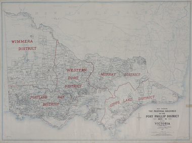
Plan, Map Showing the Pastoral Holdings of the Port Phillip District 1835-1851 Now Victoria, 1932, 1932
Another name for Pastoral Holdings is squatting runs. Information on Alfred Stephen Kenyon of the Historical Society of Victoria can be found at http://adb.anu.edu.au/biography/kenyon-alfred-stephen-6936/text12035 Map of Victoria showing the boundaries of the Port Phillip District (Victoria) pastoral boundaries. pastoral holdings, squatters, squatting, victoria, land, crown lands, a.s. kenyon, alfred stephen kenyon -
 Federation University Historical Collection
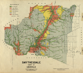
Map, Smythesdale, County of Grenville, 1888, 1889
The map maker, Ferdinand M. Krause, was a professor at the Ballarat School of Mines. This land was printed form the Crown Lands Department, Melbourne. Coloured map of the County of Grenville. The edge has been taped. The scale is 40 chains to 1 inch. The map is accompanied with a foolscap sheet printed by the Mines Department in 1898. It is a Report on the Parish of Smythesdale by F.M. Krause and includes information on the water reserve, worked quartz veins, Watson's Hill, Surface Hill and Sugarloaf Hill, Haddon, Trunk Lead and the Crucible Shaft. smythesdale, krause, f.m. krause, ferdinand krause, nitingbool, watson's hill, surface hill, sugarloaf hill, haddon -
 Federation University Historical Collection
Book, Yallourn, 10/1962
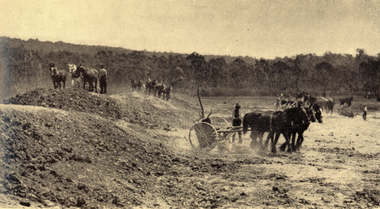
In the foreword the Chairman and General Manager, W.H. Connolly, wrote: "Australia's progress since the Second World War has been remarkable - and nowhere more so than in Victoria. Although the smallest pf the mainland States, Victoria is today the most highly industrialised, the second most populous and the most rapidly developing State in the Commonwealth. Many factors have contributed to this growth, bu the one of greatest importance is the vast wealth of easily extractable brown coal in the Latrobe Valley which is the source of Victoria's electricity and a major part of its solid fuel. ... "White and green soft covered book of 34 pages with black & white and coloured illustrations. The book includes starts with an historical section, and includes information the open cut, Yallourn Power Station, Yallourn Briquette Works, the town, Morwell Open Cut, and includes a map of the Latrobe Valley Brown Coal resources.yallourn, connolly, open cut, power station, kernot, coal, briquette, lyle, monash, yallourn open cut, yallourn power station, yallourn briquette works, morwell open cut, hazelwood, brown coal, gippsland, horses, turning sod -
 Federation University Historical Collection
Medal - Numismatics, ANZAC Commemorative Medal for R.M. Serjeant, 1967
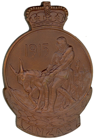
Robert M. Serjeant was the only son of Theo and Alice Serjeant, and grandson of famed mine manager Robert Malachy Serjeant (1829-1902). Robert Serjeant was a past student of the Ballarat School of Mines (SMB), and at the time of his World War One enlistment he had just finished an electrical course, and was working as a junior member of the SMB Department of Electricity. Robert Serjeant enlisted in December 1914. Corporal Serjeant (2138) of the 8th Battalion, died of wounds received in action at Gallipoli on 28 April 1915, aged 20. He was buried at sea and his name is listed at the Lone Pine Memorial. A brown paper parcel of Robert Serjeant's belongings was returned to his parents. It contained his discs, wrist-watch (damaged), notebook, hymn book and letters. [1] The Ballarat Courier reported: 'He was of quiet disposition, and a great student, devoting himself closely to his work.' Further information on R.M. Serjeant can be found at https://bih.federation.edu.au/index.php/Robert_M._Serjeant_Jnr The following statement on the ANZAC Commemorative Medallion and Badge was made by by Prime Minister Holt in 16 March 1967 when the Minister for Defence announced that it had been decided by the Australian Government, in consultation with the New Zealand Government, to issue a medallion and lapel badge to the veterans of the Gallipoli Campaign. "Last March, the Minister for Defence announced that it had been decided by the Australian Government, in consultation with the New Zealand Government, to issue a medallion and lapel badge to the veterans of the Gallipoli Campaign. I am glad to be able to announce that arrangements have now been completed for the production of the medallion and the badge. The Minister for the Army will be arranging distribution to those wishing to receive them as soon as possible. The Government hopes that production of the medallion and lapel badge will be sufficiently advanced to permit at least some of them to be distributed by ANZAC Day. The medallion (with the name of the recipient inscribed) will be issued to the surviving members of the Australian Defence Force who served on the Gallipoli Peninsula, or in direct support of the operations from close off-shore, at any time during the period from the first ANZAC Day in April, 1915 to the date of final evacuation in January, 1916. Next of kin or other entitled persons will be entitled to receive the medallion on behalf of their relatives, if the relative died on active service or has since died. For surviving members, a lapel badge will also be available for wearing. This will be a replica of the obverse (or front) of the medallion and will be about 1 inch high and 2/3 inch wide - the same size as the RSL badge. The medallion is the work of Mr. Raymond Ewers, the well-known Australian artist, based on a suggestion by Mr. Eric Garrett, a staff artist with the Department of the Army. It has been endorsed by both the Government of New Zealand and ourselves. It will be approximately 3 inches high and 2 inches wide. The obverse of the medallion depicts Simpson and his donkey carrying a wounded soldier to safety. It will be bordered on the lower half by a laurel wreath above the word ANZAC. The reverse (the back) shows a relief map of Australian and New Zealand superimposed by the Southern Cross. The lower half will be bordered by New Zealand fern leaves. The medallion will be cast in bronze and the lapel badge will be metal of a bronze colour. For the information of the honourable members I present also a brief statement setting out the conditions of eligibility which will apply to the medallion and badge and the manner in which those desiring to receive them should apply."(https://www.awm.gov.au/encyclopedia/anzac/medallion/doc.asp, accessed 26/02/2014) Conditions of eligibility. All members of the Australian Defence Force who served during the Gallipoli Campaign are entitled to receive the ANZAC Commemorative medallion. The campaign lasted from April 25, 1915 to January 8, 1916. The award will be made for service on the Gallipoli Peninsula and service in support of the operations in an area off-shore eastward of a line drawn from Yukyeri Point (lat 39 50' 40'' N long 26 9' 45'' E) through a point in lat 39 53' N long 26 0' E thence to Cape Gremea (lat 40 35' N long 26 6' E). The award will also be available to members of philanthropic organisations and the Press who were accredited to the AIF, and to Australian members of the crews of merchant ships or hospital ships which operated in direct support within the defined area. Note: The boundary line would run just off-shore from the land masses north and south of the Dardanelles, and is estimated to be within about 5 miles from the beach at ANZAC Cove. (https://www.awm.gov.au/encyclopedia/anzac/medallion/doc.asp, accessed 26/02/2014) This Item is significance because is was only issued to members of the Australian and New Zealand Defence Force who served at Gallipoli. This Medallion is significant because of its relationship to Robert M. Serjeant who died on 28 April 2015 at Gallipoli of wounds received in Action. Bronze commemorative medal in black presentation case showing Simpson and his donkey carrying a wounded soldier to safety. A crown is situated on top of the medal, and the word ANZAC beneath the medal. The opposite side depicts Australia, New Zealand and the Southern Cross Constellation. The lower half is bordered with New Zealand Fern leaves. The commemorative medal was presented to the family of Robert M. Serjeant. Gift of David Stevens, 2014.Engraved: "1238 R.M. Serjeant"serjeant, r.m. serjeant, robert m. sergeant, anzac, medal, numismatics -
Federation University Historical Collection
Letter - Photocopy of letter, Letter regarding the naming of Vincent Drive, Mount Helen, 1984, 1984
Provides information about the naming of Vincent Drive Ballarat University 1984. Vincent Drive was named in recognition of the years of service Richard Vincent gave to the Shire of Buninyong as a councillor.Photograph of letter plus a Ballarat University campus map showing Vincent Drive, plus a newspaper clipping and photocopy of the clipping regarding a new access road to the Ballarat Technology Park ( The Courier, Ballarat, Tuesday, March 19,1996).vincent drive, federation university, buninyong shire, ballarat university, ballarat technology park -
 Flagstaff Hill Maritime Museum and Village
Document
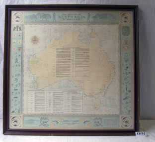
... 1) Large map of Australia with information on explorers... map of Australia with information on explorers, navigators etc ...1) Large map of Australia with information on explorers, navigators etc involved in its discovery. Title "The Discovery of Australia by Western Man" 2) Poster which explains in full information formulated on .1 Also gives in great detail natural history information relevant to the formation of the Australian continent.flagstaff hill, warrnambool, shipwrecked-coast, flagstaff-hill, flagstaff-hill-maritime-museum, maritime-museum, shipwreck-coast, flagstaff-hill-maritime-village -
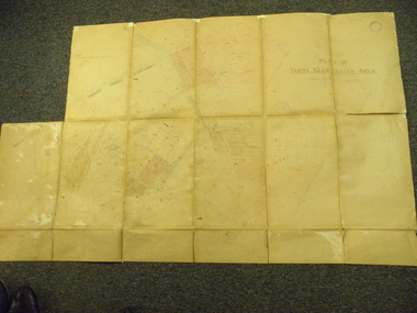 Yarra Glen & District Historical Society
Map, Plan of Yarra Glen Water Area
The map has been used by water supply officers to map the supply of water to properties in the township area of Yarra Glen.The item is significant because it records changes to the supply of water to Yarra Glen over a period of approximately 100 years. It also records property owners and subdivisions.Flat map which folds into 12 pages with a dark red cloth cover. One page in top left corner is missing. Scale of the map is 300 feet to an inch. Cream coloured packing tape has been placed along the back of the folds and is now peeling off.Round stamp in top right corner "Shire of Eltham". Pencil note on top left existing page "Note - includes record of 8 LP's subdivisions. HC". Information has been added to the map over an extended period of time in red ink, black pencil, blue pencil and blue biro.yarra glen/water supply/ -
 Federation University Historical Collection
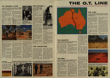
Newspaper, Overland Telegraph Centenary, 1972, 1972
.1) Overland Centenary Supplement to The Australian. Six pages of information and images including the Roper River Camp, First Telegraph Pole at Port Darwin, Route of the Overland Telegraph, Australian Telecommunications Development Association, Alice Springs, Frew's Ponds. Charles Todd, Alice ToddFrank Kraegen, Pony Express. .2) 'The O.T. Line' - four page coloured news shhet published of by the Australian Post Office for the Overland Telegraph Line Centenary, 22 August 1972. Includes articles and images such as J.A.G. Little (Darwin Poatmaster), Robert Patterson, Charles Todd, A.J. Mitchell (surveyor), Maps of the sections (Begot's contract, Central Sections, Darwent and Dalwood contract, Patterson contract), planting of the first pole at Darwin, Roper River Camp, Charles Todd, Alice Todd, Alice Springs Repeater Station, Grave of Kavenagh, Roper River, Frank Kraegem, Maryvale station.roper river camp, telegraph pole, port darwin, overland telegraph route, australian telecommunications development association, alice springs, frew's ponds, charles todd, alice todd, frank kraegen, pony express -
Federation University Historical Collection
Booklet - Booklet - Prospectus, McCarron, Bird and Co. Printers, Collins Street, Melbourne Junior Technical School, Prospectus, 1917, 1917
Used at Ballarat School of Mines and Industries. The Melbourne Junior Technical School opened in 1912. It was a School for Junior Technical Work in Science, Art and Trade.` Information about aim of school, constitution, council, day courses, scholarships, holidays, evening courses, regulations, rules, sports, staff, students and syllabus. The first page is a Roll of Honor. Teachers and students who have enlisted in the A I F - First World War - are named. Those who have been killed in action, died or wounded are identified. Teachers - Maj. G M Nicholas (killed in action), R Hudspeth, E Harris, K B Nelson. Students - Lieut. H D Harvey (wounded), C Ash, A Addicoate (died), W H Barkley, H A Barker, L A Baker, R B Brisbane, W Berryman, G T R Cooper (wounded), D Clarke, A H Cheetham, A Ferguson, N L Ferguson, L Falconer, J A Fontaine, E A Geach, V E Hall, A J T Hamilton, I J Lang, C Leith, T R Lydster, R Morley, Gordon W Morrison, H K McNeill, N McCormick, W McConnochie, G F Nicholson, A L Nixon, T Nesbitt ( killed in action), E S Pugh, H P Philpott, R Quirk, R Shaw, J V Shelton, G W Stevens, W H Suttie, J Stewart (died), E Sharp, F W Schultz, D N Turpie, J Tyson, H Turner (died), A Woodgate, W R White, A G Wilson, H R York. Brown soft covered booklet with crest with information on teachers, students, aim of the school, compulsory drill, council, courses, fees, hours, holidays, map of the school, roll of honor and subjects. It includes photographs of the day school students, experimental science, sheet-metal work, woodwork, science workshop, modelling, blacksmithing and a drawing of the Working Men's Collegemelbourne, melbourne junior technical school, prospectus, principal, p mccormick, senior master, w bruce, trades, c greenhill, e harris, r kinross, c juncken, a dunstan, w hudspeth, e willison, a lawson, c blacker, r dannatt, mathematics, d j morris, g w irving, miss r m lewis, english, a j hauser, g a taylor, miss k e lamrock, i taylor, science, r a white, h carr, j connellan, t e kilshaw, a thomas, art, w gilmore, j n rowell, f g blachshaw, physical culture, lieut w hudspeth -
 Federation University Historical Collection
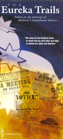
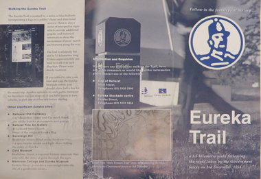
Brochure, Eureka Trail, c2000
The brochure gives information on the Eureka Stockade which took place on 03 December 1854. The Eureka trail aimed at enhancing the Eureka experience and was developed in 1996. It was managed by the City of Ballarat with funding assistance form the State and Federal governments. Much of the work was undertaken under the New Work Opportunity Programme.Blue and white brochure highlighting relevant Eureka Stockade site. The brochure includes a map showing the route the Government forces took on their way to the Eureka Stockade as well as sites of interest to Eureka which are marked by blue bollards. The brochure was presented by the City of Ballarat and the Eureka Stockade centre.eureka, eureka stockade, diggers' trail, trooper's trail, eureka stockade centre, city of ballarat -
 Federation University Historical Collection
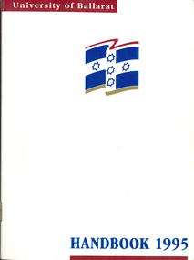
Book - Handbook, University of Ballarat Handbook, 1995, 1995
The University of Ballarat was formed in 1994, and is a predecessor organisation of Federation University Australia. White covered book with blue and maroon printing and logo. Information includes staff, admission policies and procedures, fees, Aboriginal and Torres Strait Islander Students, Scholarships, accomodation, International Students, courses, units, academic regulations, E.J. Barker Library Regulations, Appeals, Non-Sexist language, Student discipline, Academic Board Policy, Student Union, Enrolment, Parking, Campus plan, Locality map.university of ballarat handbook, courses, student association, marg thorne, mary rhyne, vicki anwyl, jenny geddes, wendy keyte, lynne billstone-convery, toni palmer, mary williams, steve blomeley, jenny gallagher, tracey fox -
 Federation University Historical Collection
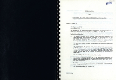
Report, SMB: Review Survey of Buildings and Grounds, July 1985, 1985
Report of the detailed review of The School of Mines and Industries Ballarat Limited undertaken by Alexander & Alexander in 1985. Previous reports were done in 1982 and 1983. The report covers all areas of the school - buildings and grounds. Some sections/buildings are still being completed. Report contains written evaluation, maps/diagrams and photographs.Spiral bound book - dark blue cover. 15 pages of written information plus 3 pages of photographs.Gold lettering on from cover "Alexander & Alexander" Signature "J W Elliott" on page 10 (Loss Control Surveyorballarat school of mines and industries, survey, alexander and alexander, j w elliott, maps, photographs -
 Federation University Historical Collection
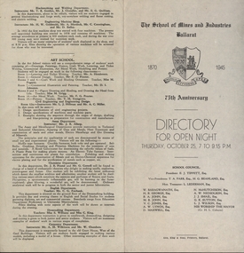
Programme, School of Mines: 75th Anniversary, Directory for Open Night, 1945, 1945
To celebrate the 75th Anniversary of the School of Mines and Industries an Open Night was held on Thursday, October 25 (1945) from 7 to 9.15 p.m. The Principal was Mr A Heseltine and the Registrar was Mr F Ferguson. Members of the School Council included E J Tippett, M G Beanland who have a building or walkway named after them. A map of the buildings shows the various areas and information is given for each department. Though it was an Open Night it would also serve as an Information Night for student enrolling for the following year.Paper folded in half and printed on each of the four sections. Map showing layout of buildings. Information on each department of the school.ballarat school of mines and industries, 75 anniversary, a heseltine, principal, f e ferguson, registrar, e j tippett, m g beanland, open night, information night -
Glenelg Shire Council Cultural Collection
Administrative record - Progress Report of Portland Harbour - Royal Commission of Victoria, 1925
Retrieved from the files of the former Maritime Discovery Centre Manager at the Portland Information Centre (A copy of this report is listed in the manifest from the Port of Portland when collection was offered in 1995)Front: Capt. J W Brown -inkport of portland